
Weekend Outlook: Hot with Isolated Storms

The Southern Tennessee Weather Blog is proudly presented by Heritage South Community Credit Union.
We Help When Others Won’t!
Visit https://www.heritagesouth.org/ today to see how HSCCU can help YOU!
We have finally made it to the weekend, but unfortunately, Mother Nature did not get the memo that we're now several days into meteorological fall. Another very hot and humid afternoon is underway across Southern Middle Tennessee, and the heat will remain the biggest weather story through Saturday. There will also be opportunities for a few showers and thunderstorms, particularly Saturday afternoon and evening, but I certainly wouldn't call this weekend a washout.
In fact, quite a bit of the weekend should be dry. The bigger change arrives behind a weak front Saturday night. It won't exactly deliver a blast of fall air, but it should knock down the humidity enough to make Sunday feel noticeably better.
One More Day of Dangerous Heat
A Heat Advisory remains in effect through 8 PM Saturday across Southern Middle Tennessee as our stubborn stretch of late-summer heat continues. This afternoon, temperatures will climb into the middle and upper 90s across most of the area, with a few of our typically hotter locations potentially approaching 100°. Throw in plenty of humidity, and Heat Index values could reach between 105° and 110° during the hottest portion of the afternoon. An isolated shower or thunderstorm can't be ruled out this afternoon, but coverage should remain quite low. Most communities will stay completely dry.
If a storm does manage to develop, however, don't completely ignore it. The combination of intense surface heating and a very unstable atmosphere could allow a stronger storm to produce gusty or locally damaging winds, heavy downpours and frequent lightning. Any storms that develop should fade this evening, leaving us with another warm and muggy night. Overnight lows will generally fall into the 70s, providing relatively little relief from the heat.
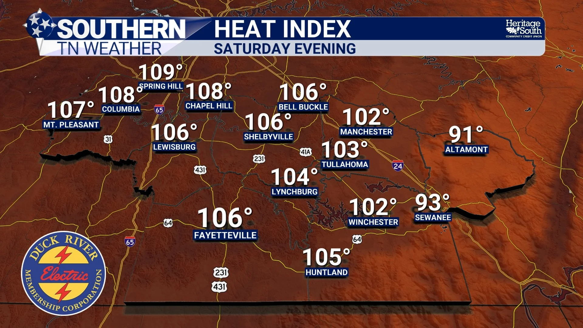
HEAT INDEX - SATURDAY EVENING
Saturday: Still Hot, But A Few More Storms
Saturday will probably be the more active weather day of the weekend, although I want to emphasize that this does NOT look like an all-day rain event. Our large area of high pressure will continue retreating westward while the upper-level flow turns more northwesterly. That will allow a weak disturbance and associated front to approach Tennessee. In simpler terms, we'll finally have a little more help in the atmosphere to get thunderstorms going.
We'll still start Saturday very hot and humid, with afternoon temperatures climbing well into the 90s. Heat Index values could once again reach 105° or higher, especially before thunderstorms become more numerous. That's why the Heat Advisory continues through Saturday evening. As we move through the afternoon and evening, scattered thunderstorms should begin developing. Coverage still looks somewhat hit-or-miss, so some communities may get a soaking while others don't see much of anything.
There is also some uncertainty regarding exactly when storms become most numerous. Current guidance suggests activity could increase during the latter half of the afternoon and into the evening as thunderstorm outflow and the weak front move into the region. Some storms could linger beyond sunset, particularly farther south toward the Alabama state line.
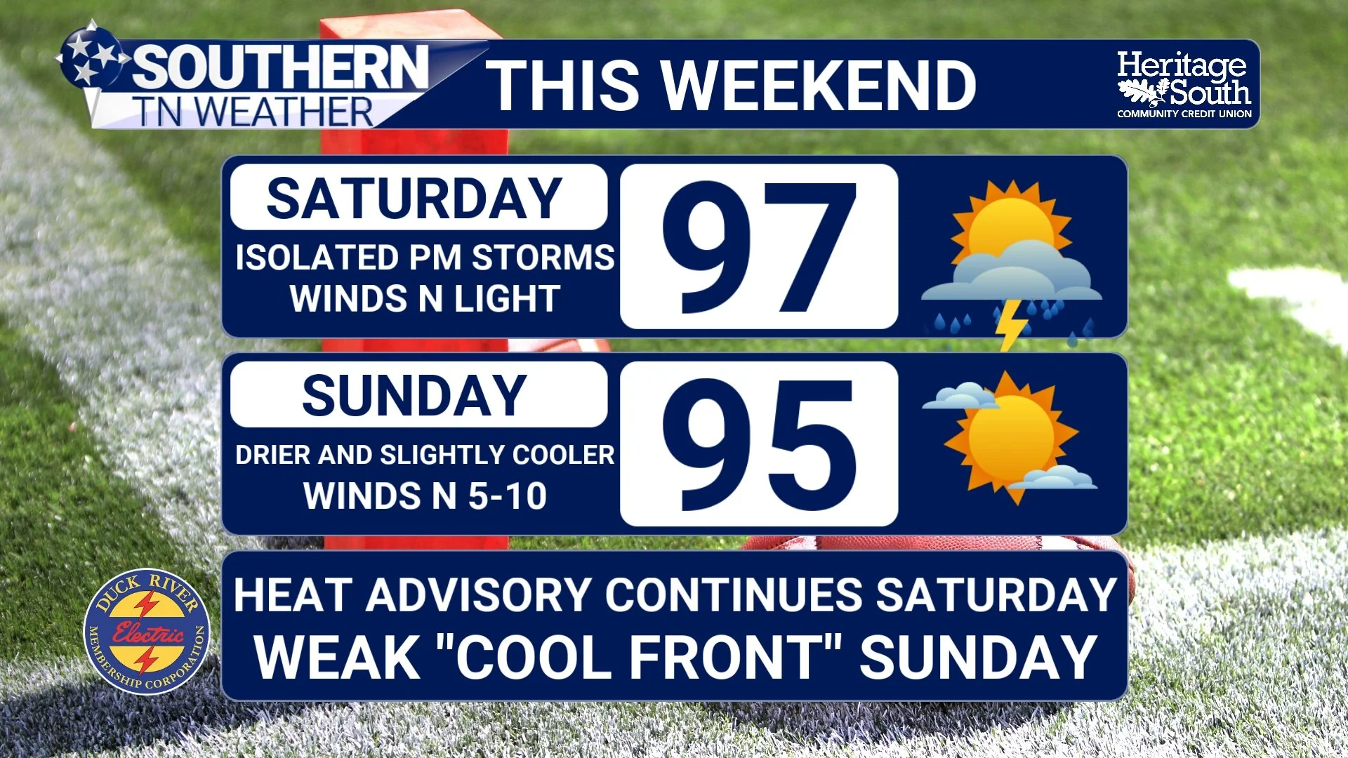
STNWX FORECAST - THIS WEEKEND
Could Any Storms Become Strong?
Yes, a few could. But widespread severe weather is not expected. The Storm Prediction Center's broader concern for organized damaging storms Saturday is focused farther northeast around portions of the Ohio Valley and Appalachians. Across our area, wind shear is relatively weak, which should limit how organized thunderstorms can become. However, we're going to have plenty of instability thanks to the tremendous amount of heat near the surface. That means thunderstorms won't necessarily need an impressive severe-weather setup to produce problems.
The strongest storms Saturday afternoon and evening could produce strong to locally damaging wind gusts, frequent lightning and very heavy rainfall. Storms could also develop fairly quickly once they get started, so keep an eye on the radar if you have outdoor plans. A MARGINAL risk (level 1 out of 5) for severe thunderstorms is in place for areas basically along and north / east of Interstate 24.
This is one of those weekends where I wouldn't cancel plans, but I would make sure you have a way to receive weather alerts and somewhere nearby to go if thunder starts rumbling. And remember: if you can hear thunder, you're close enough to be struck by lightning.
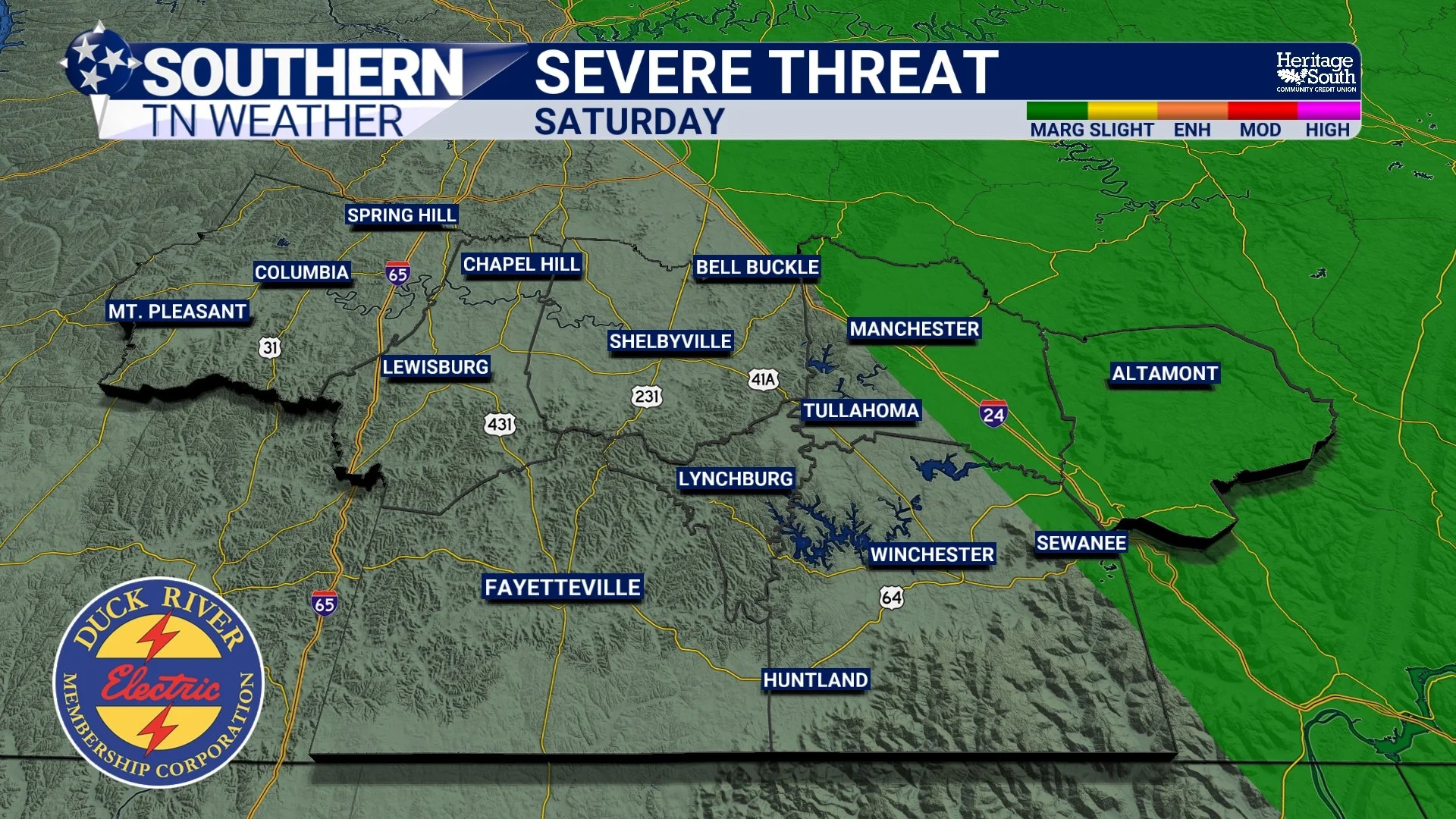
SEVERE WEATHER RISK - SATURDAY
Sunday: Still Hot... But It Should FEEL Better
Here comes the closest thing I have to good news. Behind Saturday's weak front, winds will turn more northerly and begin pulling drier air into Southern Middle Tennessee. Notice I said drier, not cold. Sunday afternoon temperatures will still be quite warm, generally reaching the lower to middle 90s. But dew points should fall compared with what we've experienced over the past several days, meaning the humidity won't be nearly as oppressive.
That should keep Heat Index values below the dangerous 105-110° levels we've been experiencing. After spending several days in air you could practically wear, we'll take it. Rain chances should also decrease considerably Sunday as the drier air settles into the region, making the second half of the weekend the better bet for outdoor plans.
What About Next Week?
If you're hoping Saturday's front is finally going to flip the switch to fall, I've got some bad news. It's still going to be hot. Temperatures should remain above normal through much of next week. Highs generally stay in the lower 90s early in the week before potentially creeping back toward the middle 90s later on. The good news is that the extreme humidity should temporarily back off, keeping Heat Index values closer to the actual air temperature. We may still flirt with feels-like temperatures around 100° at times, but current indications suggest we should avoid the widespread 105-110° readings we've experienced this week.
There will be a small opportunity for a pop-up afternoon thunderstorm Monday. High pressure then strengthens again across the Southeast around Tuesday, which should shut down most rain chances for at least a few days. Another subtle pattern change could bring low-end thunderstorm chances back toward the end of next week. So, no, fall isn't arriving this weekend. But after this week's heat, lower humidity Sunday might be enough to fool us for a few minutes.
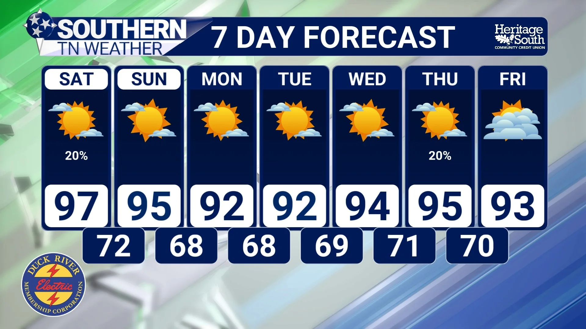
STNWX 7-DAY FORECAST
The Bottom Line 🧾
🔥 Heat Advisory through 8 PM Saturday across Southern Middle Tennessee.
🥵 Heat Index values could reach 105-110° again this afternoon and Saturday.
⛈️ An isolated storm is possible this afternoon, but most communities stay dry.
🌩️ Thunderstorm chances increase Saturday afternoon and evening, but this does NOT look like an all-day washout.
💨 The strongest storms could produce strong to locally damaging winds, heavy rain and frequent lightning.
☀️ Sunday looks drier with highs still in the 90s.
🍃 Lower humidity arrives Sunday, making it feel noticeably better despite the continued heat.
🌡️ Above-normal temperatures continue next week, although the extreme Heat Index values should ease.
🍂 And no... fall still isn't ready to show up just yet.
📰 Reminder: The Southern Tennessee Weather Blog, presented by Heritage South Community Credit Union, is updated Monday through Friday with fresh, locally tailored forecasts you can trust.
