
Weather Folklore: Is Lingering Snow “Waiting” on Another?

The Southern Tennessee Weather Blog is proudly presented by Heritage South Community Credit Union.
We Help When Others Won’t!
Visit https://www.heritagesouth.org/ today to see how HSCCU can help YOU!
Yesterday we cracked open persimmon seeds to see if they could tell us what winter has in store. Today, we're sticking with the winter weather theme—mostly because talking about snow is about the only way I can mentally escape the sauna outside right now. 😂 This piece of folklore is one I've heard plenty of times after a good Southern snow: “If snow stays on the ground for several days, it's waiting on another one.”
In other words, if an old snow refuses to completely melt away, another round of snow supposedly isn't far behind. I've even heard people take it a little further and say that “snow won't leave until another snow comes to take its place.” It's a neat saying, and unlike yesterday's persimmon seed forecast, there actually IS a little meteorology hiding underneath this one. But the snow itself isn't predicting anything.
Where Did This Saying Come From?
Finding one definitive origin for this particular saying is difficult. It's one of many pieces of winter weather folklore passed down orally through generations, particularly in rural communities where people relied heavily on observations of the land and sky to anticipate changes in weather. And you can understand how this one developed. Imagine living before weather apps, satellites, radar, or computer models. A snowstorm comes through and leaves several inches on the ground. Instead of warming up the next afternoon and melting away, the snow sticks around.
Monday... still snow. Tuesday... still snow. Wednesday... STILL snow. Then another winter storm arrives Thursday.
See that happen a few times and eventually somebody is going to decide that the first snow was “waiting on another.” But there's an important reason those two events can occasionally happen together.
WEATHER FOLKLORE - WEDNESDAY EDITION
Why Does Snow Sometimes Stick Around for Days?
For snow to remain on the ground, something has to prevent it from melting. And obviously, temperature is a big part of that. If temperatures remain near or below freezing (especially overnight) snow can survive for several days. A fresh snowpack can also help keep temperatures colder near the surface because snow reflects a large percentage of incoming sunlight rather than absorbing it. That's known as albedo.
Snow also requires energy to melt. So even when the air temperature briefly climbs above 32°, several inches of snow aren't necessarily going to disappear immediately. Cloud cover, shade, snow depth, wind, humidity, ground temperature and the angle of the winter sun can all affect how quickly a snowpack disappears. That's why you've probably seen this happen around here: The yard is completely green again, BUT there's STILL a stubborn patch of snow sitting behind the house where the sun doesn't hit it.
That patch isn't waiting on anything, it's just refusing to cooperate!
But Here's Where the Folklore Gets Interesting
Suppose we get a snowstorm across Southern Middle Tennessee and temperatures remain unusually cold for the next four or five days. That tells us something about the weather pattern. A persistent trough may be keeping cold air locked across the eastern United States. The jet stream may remain favorable for Arctic air to continue spilling southward. Or a blocking pattern may prevent the overall setup from changing very quickly. And if that cold pattern sticks around long enough, another disturbance could eventually move through while temperatures are still favorable for snow.
Suddenly we've got old snow on the ground + another snowstorm arriving. To someone watching this happen generations ago, it might certainly look like the old snow was “waiting” for the new snow. Meteorologically, however, both events are simply products of the same persistent cold pattern. The snow on the ground didn't forecast the next storm.
Southern Middle Tennessee Makes This One Especially Tricky
Snow is already an inconsistent visitor around here. Nashville's current 1991–2020 climate normals show an average of only about 4.7 inches of snow per year, with measurable snowfall occurring on roughly six days during an average year. And even those averages can be misleading. Some winters bring practically nothing. Other winters can feature multiple systems within a relatively short period.
Nashville's snowiest season on record produced 38.7 inches during 1959–60, while its largest monthly totals include 18.8 inches in January 1948, 18.9 inches in February 1979 and a whopping 21.5 inches in March 1892. That's a LOT of variation for a place averaging less than five inches annually. And that's exactly why this folklore can occasionally look surprisingly accurate.
If we're locked into a legitimately cold and active winter pattern, our opportunities for snow aren't necessarily isolated from one another. Several disturbances can move through before the larger atmospheric pattern finally changes. But plenty of snowfalls are followed by warmer weather and melting without another flake anywhere in sight.
Does Snow Cover Help Keep It Cold?
Here's another tiny piece of truth.. A substantial snowpack can influence temperatures near the ground. Fresh snow is extremely reflective. Rather than absorbing much of the sun's energy and warming the ground, it sends a large portion of that energy back upward.
At night, snow-covered areas can also become extremely cold under clear skies and light winds. So an existing snowpack can sometimes help reinforce cold surface temperatures. But (and this is important) it cannot create another storm system. It can't summon moisture from the Gulf. It can't dig an upper-level trough across Tennessee. And it definitely can't order another half-foot of snow.
If only forecasting winter weather were that easy…
The STN Weather Verdict
Scientific Rating: ⚠️ Mostly False — But There's Some Meteorology Behind It! No, snow lingering on the ground isn't literally “waiting on another snow.” There's no scientific evidence that the survival of one snowpack can be used by itself to predict another snowfall.
However, this saying probably developed from a legitimate observation. If snow remains on the ground for several days, temperatures have likely remained cold. And sometimes the larger atmospheric pattern responsible for that cold sticks around long enough for another storm system to arrive. So the old-timers may have noticed a real relationship. They just had the cause and effect a little mixed up.
The lingering snow doesn't tell us another storm is coming, but the persistent weather pattern sometimes explains BOTH.
A Quick Look at the Forecast
And now we're going to make the abrupt transition from talking about stubborn snowbanks to heat indices approaching 110 degrees. Welcome to August in Tennessee! Dangerous heat remains the biggest weather story across Southern Middle Tennessee through the weekend.
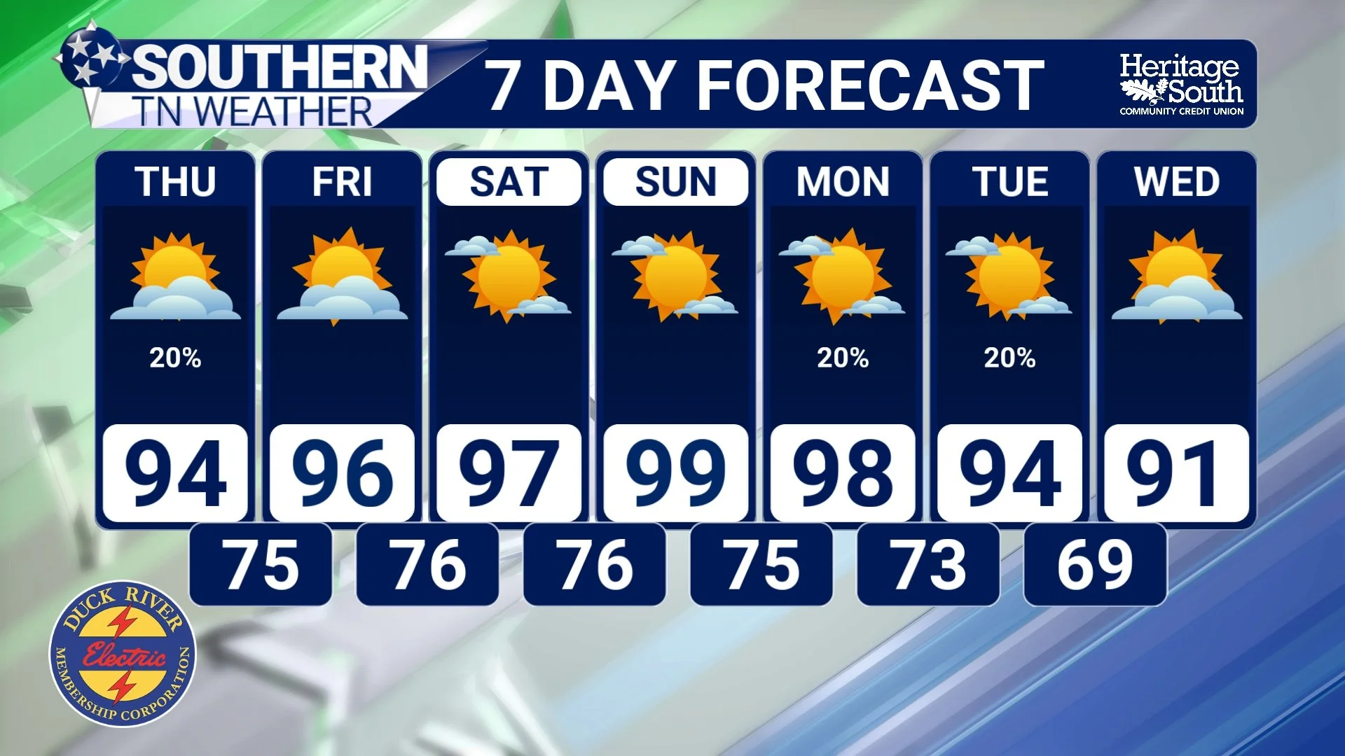
Highs this afternoon will reach the middle 90s across many locations west of the Cumberland Plateau, with triple-digit heat indices. Thursday gets even hotter, with highs climbing into the middle and upper 90s and heat index values reaching roughly 105–110 degrees in many communities.
We do still have a chance for scattered thunderstorms this afternoon and evening, particularly along and east of Interstate 65. The overall coverage remains uncertain, but the atmosphere is plenty unstable. Any stronger storms that develop could produce damaging wind gusts, frequent lightning and very heavy rainfall. A few isolated storms remain possible Thursday, mainly across our eastern areas, before strengthening high pressure largely shuts down rain chances Friday through the weekend. And unfortunately, taking away the clouds and storms will allow temperatures to climb even higher.
Friday through Sunday looks to bring the hottest stretch of this heat wave. Many locations will approach 100°, and some communities could actually reach or exceed the century mark Saturday and Sunday. Combine that with the humidity and heat index values could reach 105–110° or higher. Even the nighttime hours won't provide much relief, with lows only falling into the middle and upper 70s. Some minor relief remains possible early next week as the ridge begins shifting west and our chances for showers and thunderstorms start increasing again.
STNWX 7-DAY FORECAST
The Bottom Line 🧾
❄️ Folklore: If snow stays on the ground for several days, it's “waiting on another snow.”
🌡️ Why snow lingers: Persistent cold, snow depth, limited sunshine and other factors can keep snowpack around for days.
🔄 The grain of truth: A prolonged cold weather pattern can both preserve existing snow AND provide another opportunity for winter weather.
🚫 The catch: The snowpack itself cannot predict or cause another snowstorm.
⚠️ STN Weather Rating:Mostly False — but there's some real meteorology behind the observation.
🥵 Forecast: Forget snow for now. Dangerous heat continues through the weekend, with highs approaching 100° and heat indices potentially reaching 105–110° or higher.
📰 Reminder: The Southern Tennessee Weather Blog, presented by Heritage South Community Credit Union, is updated Monday through Friday with fresh, locally tailored forecasts you can trust.
