
Unseasonable Warmth Settles In as Eyes Turn to Active Weather Late Week

The Southern Tennessee Weather Blog is proudly presented by Heritage South Community Credit Union.
We Help When Others Won’t!
Visit https://www.heritagesouth.org/ today to see how HSCCU can help YOU!
Southern Middle Tennessee is entering a stretch of weather that feels far more like early spring than early January. This has been a familiar pattern over the past several weeks, with limited cold air and repeated surges of warmth dominating the region. As of this afternoon, a broad warm pattern is firmly in place, bringing above-normal temperatures, generally quiet conditions, and only limited rain chances through midweek.
While the short-term forecast remains calm and comfortable, attention is beginning to shift toward a more dynamic system expected late this week. That system could bring widespread rainfall and a low-end severe weather threat by Friday.
Warm, Quiet Pattern Dominates the Early Week
This afternoon’s pleasant conditions are no accident. A combination of weak upper-level ridging and persistent southerly flow at the surface is allowing warm air to steadily advect northward into Southern Middle Tennessee. In meteorology, advection simply refers to the horizontal movement of air. In this case, southerly winds are transporting warmer air from lower latitudes northward into our region. As long as that south-to-north flow remains in place, temperatures will continue to run well above average.
Highs today have climbed into the lower 60s, roughly 10 to 15 degrees above normal for early January. Skies remain partly cloudy, winds are light, and overall conditions are stable and comfortable. This same setup continues into tonight, with increasing cloud cover helping to keep overnight lows mild, generally in the mid to upper 40s.
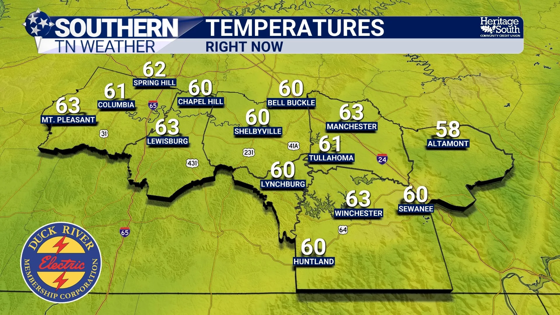
Temperatures as of 1:00 PM Monday
Tuesday and Wednesday: Still Warm, Still Quiet
The warm pattern holds steady through midweek. Tuesday will feature similar conditions, with highs again reaching the low to mid 60s, and some locations west of the Cumberland Plateau pushing slightly warmer. A weak surface trough will pass through the region, but available moisture is limited. A few light, spotty showers are possible, mainly east of I-65 and closer to the Plateau, but rainfall amounts look minimal. The probability of exceeding a tenth of an inch remains low, and for most of Southern Middle Tennessee, Tuesday will be dry.
Wednesday brings another pleasant January day. Winds briefly shift as a weak frontal boundary passes nearby, but no meaningful temperature drop or organized precipitation is expected. Highs climb into the upper 60s, keeping the above-normal warmth firmly in place.
Thursday: Warmer Still as Rain Chances Begin to Increase
By Thursday, the pattern begins a gradual transition. An upper-level system ejecting out of the Southwest increases cloud cover and moisture across the region. Southerly winds strengthen once again, enhancing warm air advection and allowing temperatures to continue rising. Despite increasing clouds, highs may reach the upper 60s to near 70 degrees, approaching 20 degrees above normal. Scattered showers become more likely later in the day, especially from west to east, though instability and large-scale forcing remain limited at this stage.
Any rain on Thursday should be light and intermittent, acting more as a preview of what’s coming rather than a high-impact event.
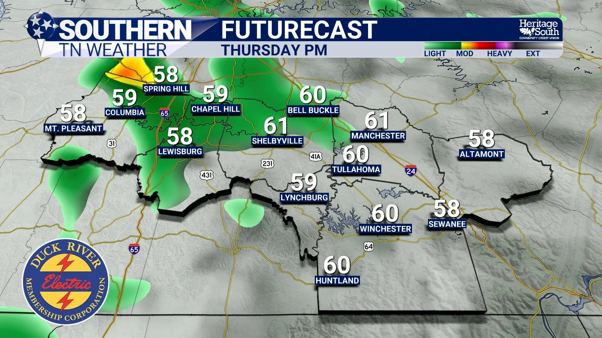
Futurecast showing some light rain showers on Thursday
Friday: Active Weather Returns, Severe Potential to Watch
Friday is the day that deserves the closest attention. A deepening upper-level trough moving out of the Rockies will push a cold front eastward into the Tennessee Valley. Ahead of this front, Southern Middle Tennessee will sit within a warm, moist air mass, with temperatures near 70 degrees and precipitable water values near or above the 90th percentile for January.
Medium to high rain chances are expected, with widespread showers and storms likely. While confidence is high in rainfall, the severe weather threat remains conditional and tied closely to instability, or storm fuel.
Current guidance indicates strong wind shear will be present, but instability values remain modest, generally in the 100 to 200 J/kg range, with uncertainty surrounding whether storms will become surface-based. If instability materializes more efficiently, organized convection could develop, particularly west of I-65, where the Storm Prediction Center is already highlighting a 15% Slight Risk in their extended outlook. At this point, this is a “monitor closely” setup, not a guaranteed severe weather event. Details regarding timing, storm mode, and impacts will continue to come into focus over the next 48 to 72 hours. It is still far too early to be sharing futurecast screenshots, but this is a system that warrants at least a little attention. Anytime it’s 70 degrees in the wintertime, I’m watching things closely…
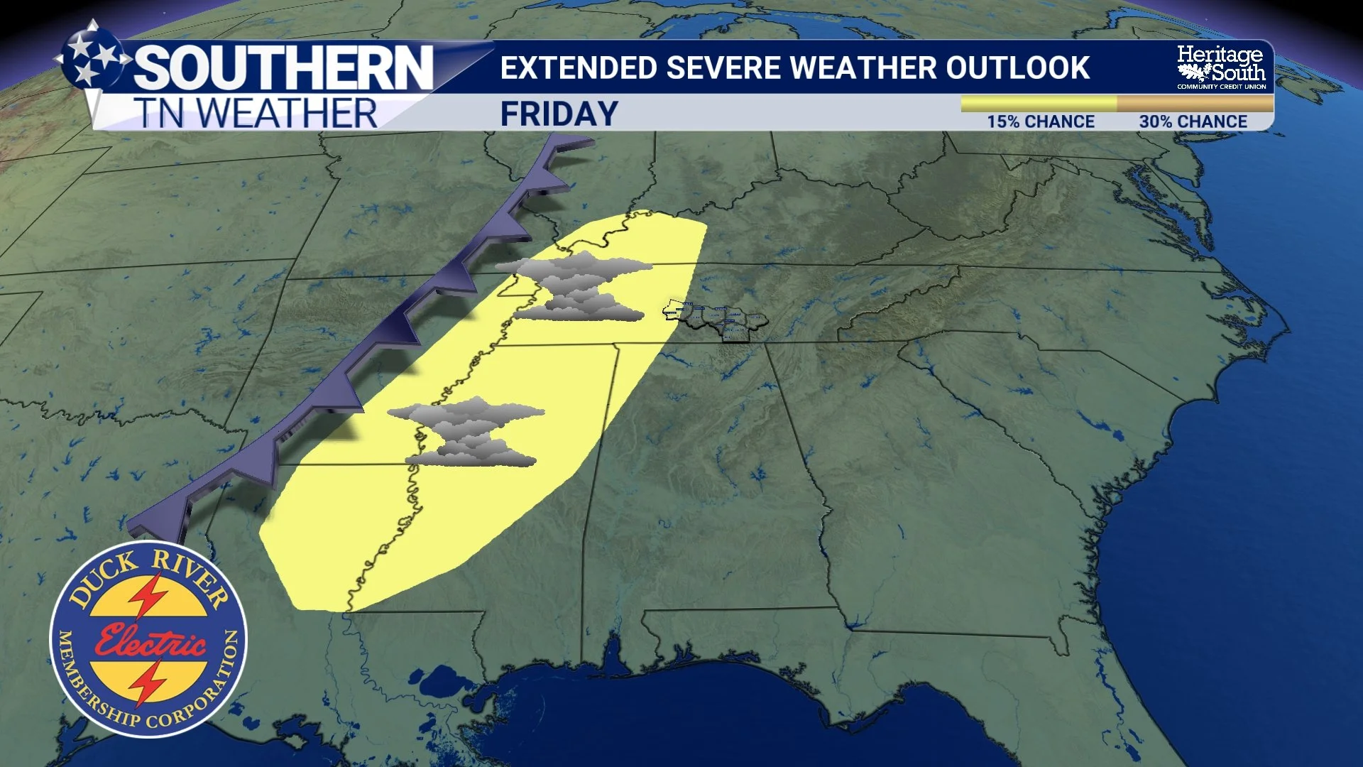
Overall Setup - Friday
Weekend Reset: Cooler, Drier, More Seasonal
Behind Friday’s system, the cold front clears the area early Saturday. Drier air filters in, and temperatures trend downward through the weekend. By Sunday, highs fall back into the 40s, with overnight lows returning to the 20s and 30s, much closer to what January should look like.
No additional significant systems appear immediately behind this front, allowing for a quieter and more seasonable end to the weekend.
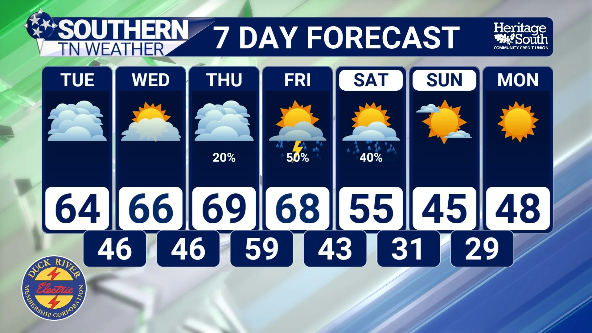
STNWX 7-Day Forecast
The Bottom Line 🧾
Unseasonably warm weather continues through midweek, with highs in the 60s and low 70s
Only isolated, light rain chances Tuesday and Thursday
A more active system arrives Friday with widespread rain and a conditional low-end severe threat
Cooler, drier, and more seasonal weather returns for the weekend
📰 Reminder: The Southern Tennessee Weather Blog (Presented by Heritage South Community Credit Union) is updated Monday through Friday with fresh, locally tailored forecasts you can trust.