
Heavy Rainfall Threat Increasing for Friday

The Southern Tennessee Weather Blog is proudly presented by Heritage South Community Credit Union.
We Help When Others Won’t!
Visit https://www.heritagesouth.org/ today to see how HSCCU can help YOU!
Southern Middle Tennessee remains locked in an unusually warm and humid pattern for early January, but the quiet stretch of weather we’ve enjoyed is beginning to give way to a much more active setup. While today and Wednesday remain relatively calm, confidence is increasing that a widespread, heavy rainfall event will impact the region late Thursday night through Friday night, with a growing potential for heavy rainfall and localized flooding.
Warm, Cloudy, and Calm for Now
This afternoon, much of Southern Middle Tennessee sits under a blanket of low clouds, with temperatures already well into the upper 50s and lower 60s. That’s roughly 10 to nearly 20 degrees above normal for early January. This warmth is being driven by persistent warm air advection, meaning winds are continuously transporting warmer, more humid air northward from the Gulf region into Tennessee. As long as this southerly flow remains in place, cold air simply cannot settle in.
Low clouds and occasional sprinkles today are the result of warm, moist air sliding over a cooler air layer near the surface. Tonight, surface high pressure briefly builds in, allowing winds to relax. With abundant low-level moisture in place, patchy fog is possible late tonight into early Wednesday, especially in low-lying and rural areas.
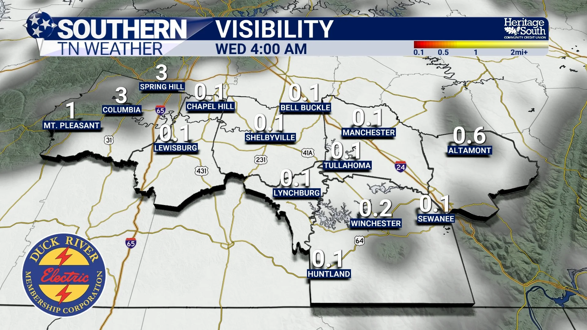
Visibility Tonight
Wednesday: The Calm Before the Pattern Turns Active
Once any morning fog lifts Wednesday, we briefly return to a classic “spring-like January” day. Skies turn partly sunny, winds remain light, and temperatures climb back into the 60s. Wednesday night stays dry, with lows only falling into the 40s. These “lows” are actually near our normal daytime highs for this time of year.
Upstream, a much stronger storm system will be organizing across the Southwest and central Plains. By late Wednesday night into Thursday, that system begins tapping into deep Gulf moisture and accelerating eastward.
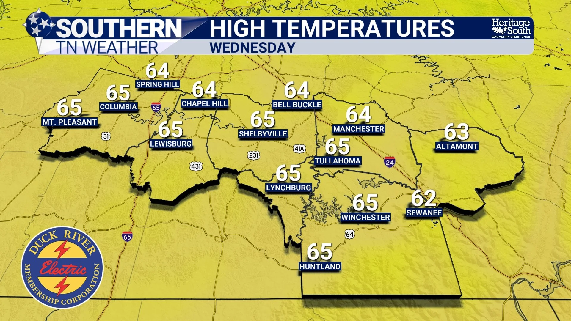
High Temperatures - Wednesday
Thursday: Increasing Wind, Clouds, and the First Signals of Trouble
Thursday will feel even warmer. Stronger south winds develop as pressure falls to our west, pulling additional warmth and moisture into the region. Despite increasing cloud cover, highs may push the upper 60s to low 70s, and a few locations could flirt with record highs. Isolated showers may develop Thursday afternoon or evening, especially in western counties, but these are not the main event.
What Thursday does is prime the atmosphere. Moisture will continue to deepen, winds will strengthen at multiple levels of the atmosphere, and the ingredients needed for a heavy-rainfall event will be firmly in place by Thursday night.
Friday: Widespread Heavy Rain Likely, Flooding Concerns Increasing
Friday remains the day to watch closely. A deepening upper-level trough will move out of the Rockies into the Mississippi and Ohio Valleys, while a surface low tracks through the region and drags a cold front eastward. Southern Middle Tennessee will sit squarely in a warm, moisture-rich air mass ahead of this front.
Forecast guidance consistently shows precipitable water values between 1.25 and 1.50 inches, placing us above the 90th to 95th percentile for January. In simple terms, the atmosphere will be loaded with moisture, and storms will be very efficient rain-producers. Both the National Weather Service and the Weather Prediction Center are highlighting our region for heavy to excessive rainfall potential. WPC has placed portions of Middle Tennessee in a Slight Risk (level 2/4) for excessive rainfall, citing the potential for training storms along a slow-moving boundary.
Important note: this is a flash flooding outlook, not a severe thunderstorm outlook. Flash flooding uses four categories (Marginal, Slight, Moderate, High) instead of SPC’s five. A Slight Risk means scattered flash flooding is possible.
Current projections show:
• Widespread rainfall totals of 2 to 3 inches possible
• 40–60% chance of exceeding 2 inches
• 30–40% chance of exceeding 3 inches, especially farther south and east
With multiple rounds of rain and storms expected, localized flash flooding becomes a legitimate concern, particularly in low-lying areas, poor-drainage locations, and near creeks and streams. This will be my main talking point over the coming days. It’s important to note that with events like this, it’s hard to nail down the exact placement of the heavy rainfall. This won’t be a widespread flooding event, but I do think some areas will see the most appreciable rainfall we’ve had in a few months.
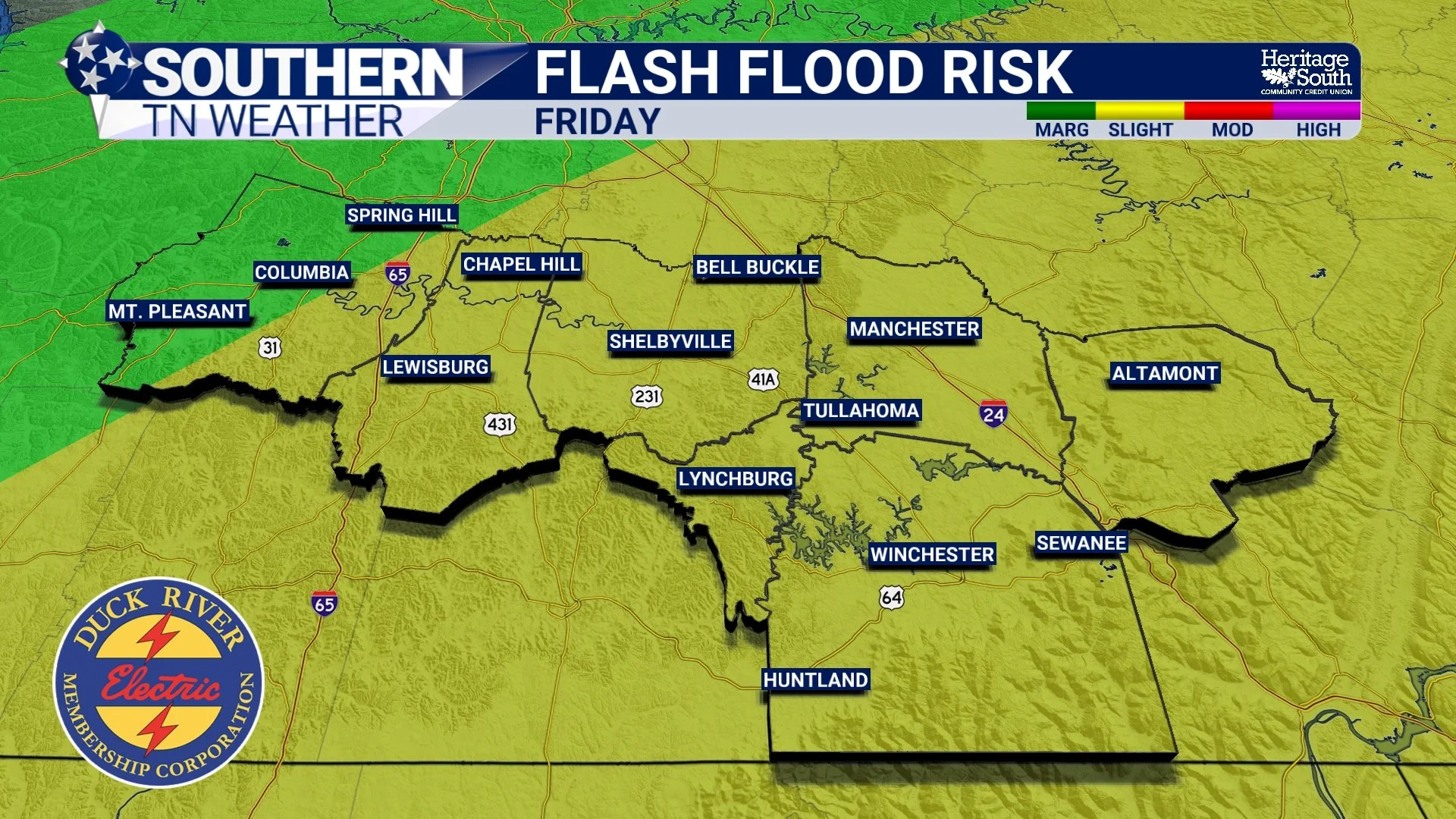
Excessive Rainfall Risk: Friday
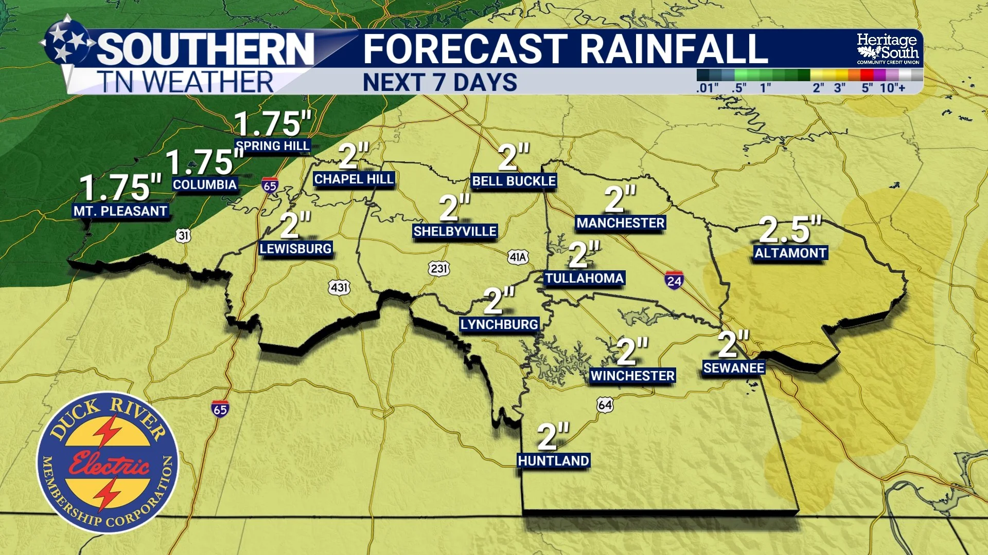
Rainfall: Next 7 Days
Severe Weather: Secondary, But Not Zero
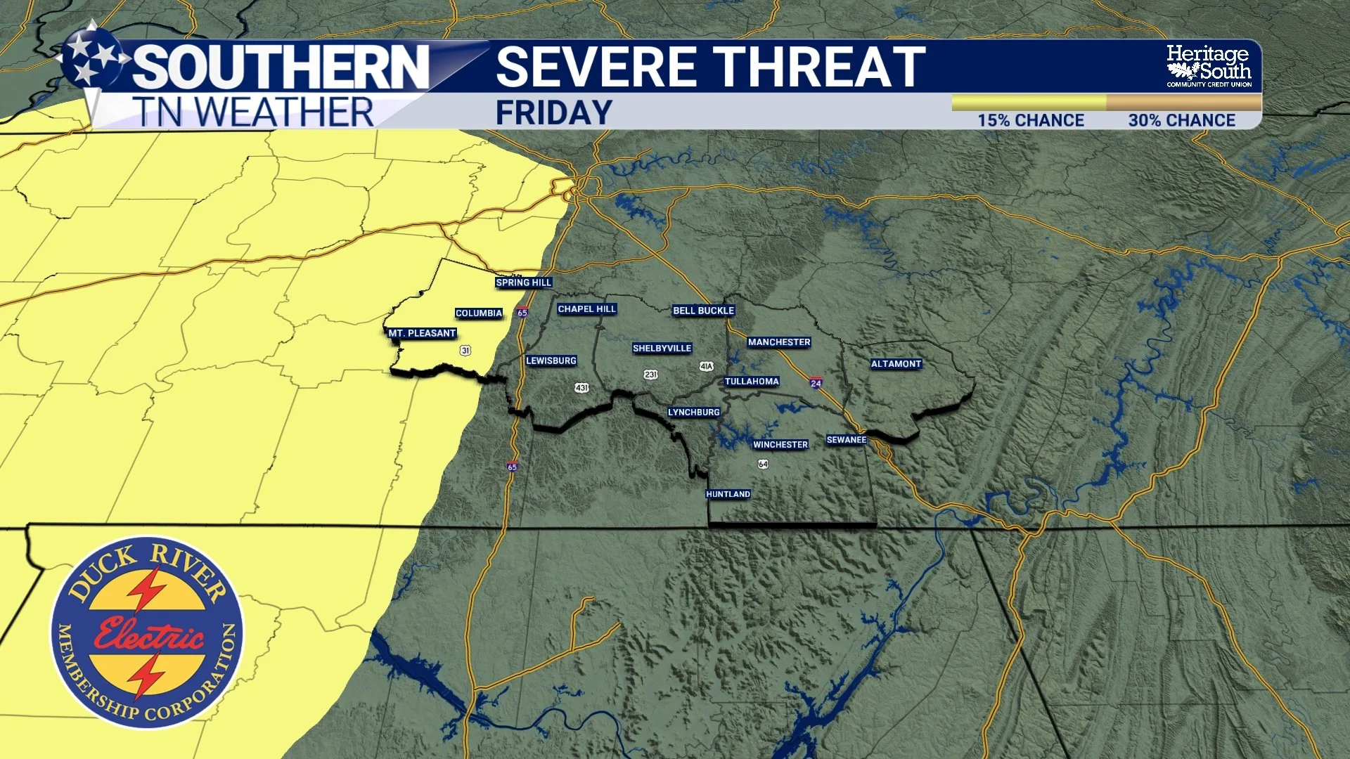
While flooding is the primary concern, Friday’s environment will also feature strong wind shear, meaning storms could become organized. Instability (storm fuel) remains the biggest question mark. Current projections suggest only modest instability (100–200 J/kg), and there is still uncertainty on whether storms will be surface-based. That limits confidence in widespread severe storms. In addition, widespread rainfall may keep the atmosphere more stable overall. The Storm Prediction Center continues their level 2/5 SLIGHT risk for severe thunderstorms on Friday. Right now, only areas along and west of Interstate 65 in Maury Co are included.
However, if instability increases more than currently forecast, a few strong to marginally severe storms would be possible, especially west of I-65 Friday afternoon and evening. Damaging wind gusts would be the main concern. Continue to stay tuned for updates as we get closer. We’re still a few days away so exact details are fuzzy.
Storm Prediction Center Outlook - Friday
After Friday’s System: Cooler, Drier, More Seasonal
The cold front pushes through early Saturday, gradually ending rainfall from west to east. Behind it, drier air filters in and temperatures trend downward. By Sunday, highs return to the 40s, with lows back into the 20s and 30s. That is much closer to what January should look like.
No immediate follow-up storm systems appear imminent, with precipitation chances remaining relatively low into next week.
The Bottom Line 🧾
• Unseasonably warm and quiet weather continues through Wednesday
• Thursday turns windier and warmer, with clouds increasing
• Friday has increasing potential for heavy rainfall and localized flooding
• Widespread 2–3 inch totals are possible in parts of Southern Middle Tennessee
• A low severe storm risk exists, but heavy rainfall is becoming the bigger concern
• Cooler, quieter weather returns this weekend
📰 Reminder: The Southern Tennessee Weather Blog (Presented by Heritage South Community Credit Union) is updated Monday through Friday with fresh, locally tailored forecasts you can trust.