
A Warm Weekend Ahead… But Rain Returns Sunday

The Southern Tennessee Weather Blog is proudly presented by Heritage South Community Credit Union.
We Help When Others Won’t!
Visit https://www.heritagesouth.org/ today to see how HSCCU can help YOU!
Southern Middle Tennessee is about to squeeze just about every season of spring into one weekend. Cool mornings are giving way to warm afternoons, humidity is still behaving itself for now, and most outdoor plans should be in pretty good shape through Saturday night. The next interruption arrives Sunday, when another quick-moving cold front brings scattered showers and a few thunderstorms back into the picture.
Friday Night into Saturday: Quiet and Comfortable
A broad area of high pressure remains in control across the Southeast today, helping provide comfortable humidity levels and seasonable temperatures across Southern Middle Tennessee. At the upper levels of the atmosphere, the overall weather pattern remains fairly active across the eastern United States. However, the stronger disturbances and deeper moisture associated with these systems are expected to remain both north of Tennessee near the Ohio Valley and south closer to the Gulf Coast region. What that means locally is fairly simple: most of us stay dry.
A few weak disturbances may drift through the region tonight into Saturday, but with limited moisture available, the atmosphere simply does not have much to work with. At most, a stray sprinkle or isolated light shower cannot be completely ruled out, especially closer to the Tennessee-Alabama state line, but many communities likely stay completely rain-free through Saturday evening. Instead, the main thing you’ll notice will be passing clouds from time to time.
Temperatures tonight will remain milder compared to the past few nights thanks to increasing cloud cover and a light south breeze. Most communities will bottom out in the lower 50s by Saturday morning, though some of the more sheltered rural valleys could still briefly dip into the upper 40s. By Saturday afternoon, temperatures warm nicely into the upper 70s to lower 80s across much of Southern Middle Tennessee. Overall humidity still looks manageable, so despite the warmer temperatures, conditions should remain fairly comfortable for early May.
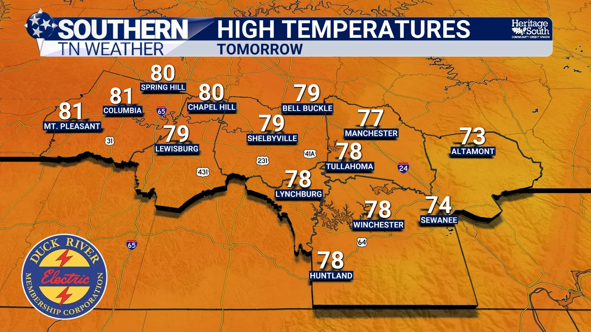
HIGH TEMPS - SATURDAY
Sunday: Rain and Storm Chances Return
The next meaningful weather maker arrives Sunday afternoon into Sunday night as a cold front pushes southeast through the region. Ahead of this front, southerly winds will transport warmer and slightly more humid air back into Tennessee. Temperatures Sunday afternoon should climb into the lower 80s for many locations. As the front approaches, scattered showers and thunderstorms are expected to develop during the afternoon and evening hours.
The good news is that this system lacks many of the ingredients typically associated with more significant severe weather events. Meteorologists often look at several atmospheric parameters when evaluating storm strength potential, including moisture, instability, wind shear, and upper-level support. In this case, those ingredients appear fairly modest overall.
Forecast surface instability values, technically called SBCAPE or “surface-based convective available potential energy,” remain relatively low. CAPE essentially measures how much fuel thunderstorms have available to grow stronger. Sunday’s values suggest thunderstorms may briefly become gusty at times, but the atmosphere does not appear primed for widespread severe weather development. Rainfall totals also appear relatively light overall. Most communities will likely receive less than one quarter inch of rain, although isolated heavier downpours could briefly occur underneath stronger thunderstorms.
At this time, the primary impacts Sunday look to be:
Periods of rain
Occasional lightning
Brief heavy downpours
Some gusty winds in isolated storms
Severe weather is NOT expected at this time. Unfortunately, with activity being scattered about during the afternoon and evening hours, there is no set timeframe. Just be weather aware if you have outdoor plans Sunday PM.
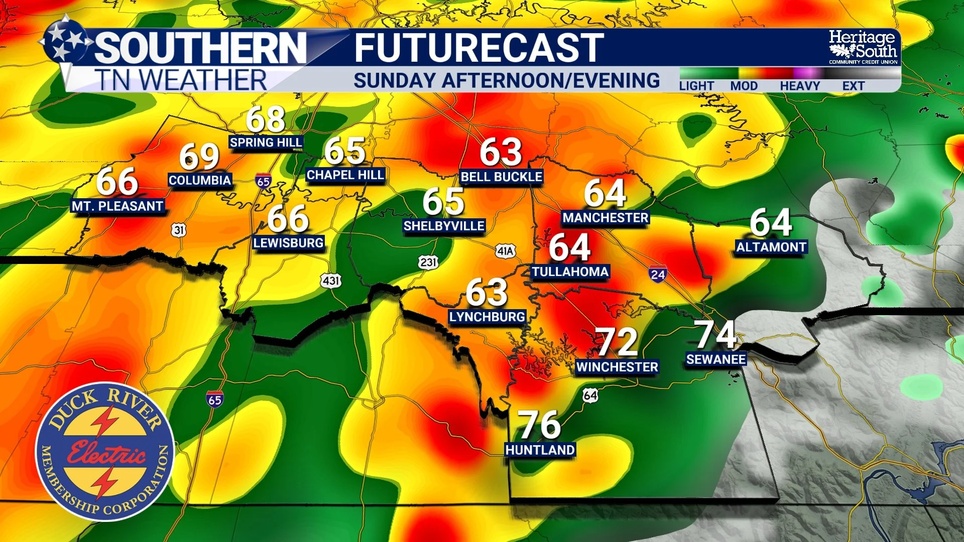
FUTURECAST - SUNDAY AFTERNOON/EVENING
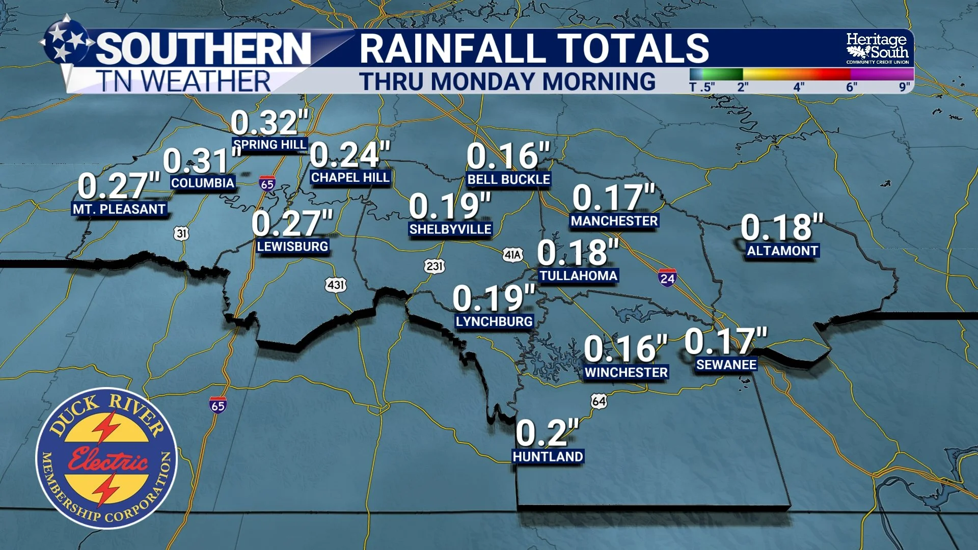
RAIN TOTALS - THRU MONDAY
Early Next Week: Cooler Again
Behind Sunday night’s cold front, another push of slightly cooler and drier air arrives Monday into Tuesday. Afternoon highs early next week will likely fall back into the upper 60s and 70s across Southern Middle Tennessee. Another weak front may slide through the region around Tuesday night into Wednesday, bringing a small chance for a few showers, but widespread hazardous weather does not appear likely through at least the next seven days.
Overall, this is shaping up to be a fairly typical and relatively calm May weather pattern for Tennessee, with periodic weak systems bringing occasional rain chances but no major storm systems currently on the horizon.
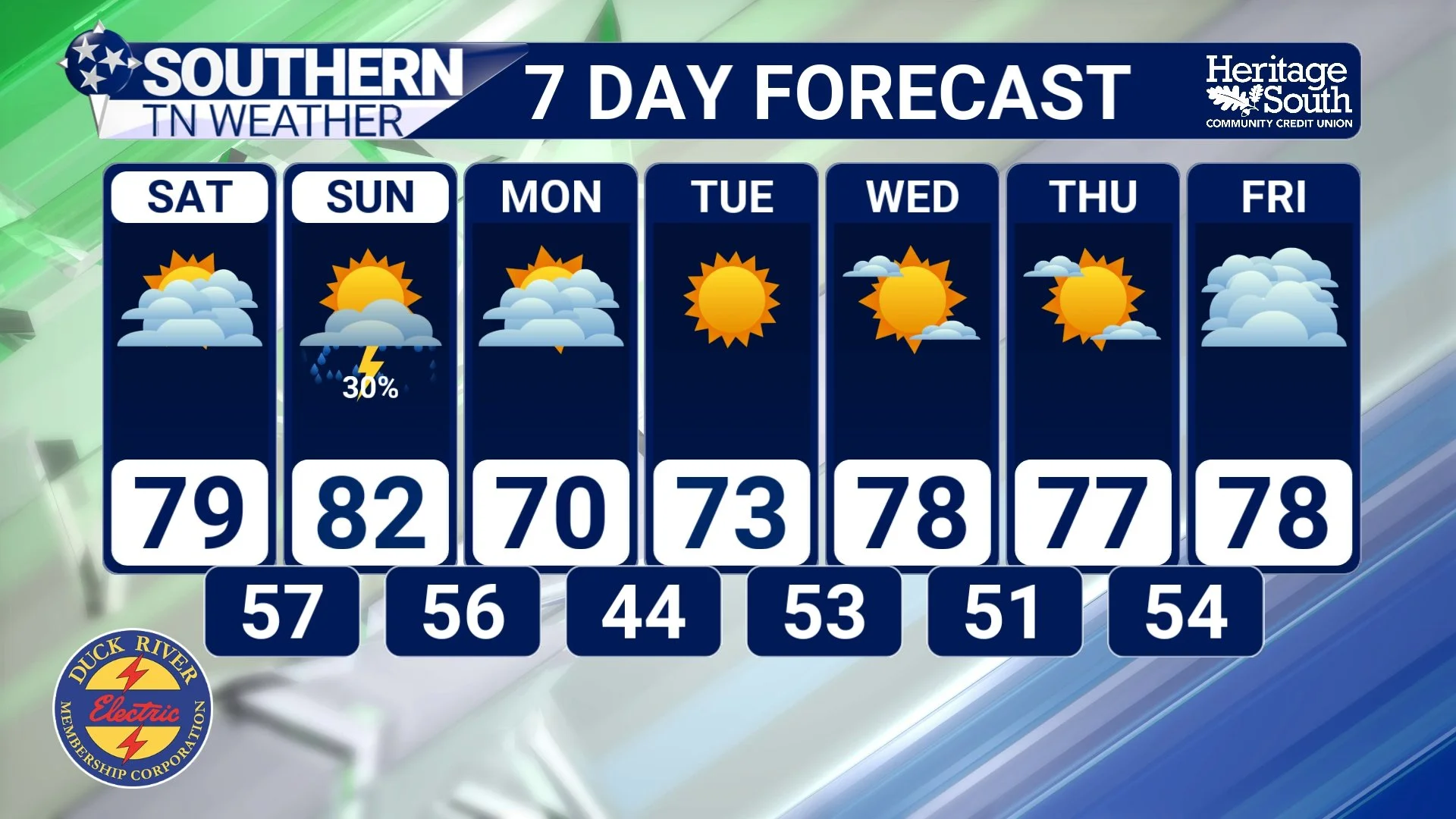
STNWX 7-DAY FORECAST
The Bottom Line 🧾
Most of Friday night and Saturday stay dry across Southern Middle Tennessee
Temperatures warm into the upper 70s and lower 80s this weekend
Scattered showers and thunderstorms return Sunday afternoon into Sunday night
Severe weather is not expected with Sunday’s system
Most rainfall totals stay under one quarter inch
Slightly cooler and drier air returns early next week
📰 Reminder: The Southern Tennessee Weather Blog, presented by Heritage South Community Credit Union, is updated Monday through Friday with fresh, locally tailored forecasts you can trust.