
Cooler Nights, A Weekend Warm-Up, and the Next Rain Chance Ahead

The Southern Tennessee Weather Blog is proudly presented by Heritage South Community Credit Union.
We Help When Others Won’t!
Visit https://www.heritagesouth.org/ today to see how HSCCU can help YOU!
After several days of rain, thunderstorms, and humidity, Southern Middle Tennessee is finally settling into a much quieter weather pattern. Cooler and drier air has filtered into the region behind yesterday’s cold front, and honestly, it feels pretty incredible outside today.
This is the kind of May weather that reminds you spring in Tennessee can still have a little personality. Crisp mornings, comfortable afternoons, low humidity, and windows-open weather are all back on the table heading into the weekend. The good news is that we’ll stay mainly dry through Saturday. The not-so-good news, if you enjoyed the sunshine, is that rain chances begin creeping back into the forecast Sunday into early Monday. Fortunately, this next setup looks fairly low-end overall.
Tonight: One of the Coolest Nights We’ve Had in a While
With high pressure building overhead tonight, skies will remain mostly clear and winds will become very light. That combination creates ideal conditions for something called radiational cooling. Radiational cooling happens when heat absorbed during the day escapes efficiently back into the atmosphere overnight. Without clouds or wind to trap that warmth near the ground, temperatures can drop quickly after sunset.
Most of Southern Middle Tennessee will wake up Friday morning in the lower 40s, with some colder sheltered valleys and outlying rural spots dipping into the upper 30s. Patchy fog will also be possible overnight, especially near rivers and valleys where leftover moisture from recent rainfall remains trapped near the surface.
Across the Upper Cumberland, a few isolated patches of light frost may briefly develop around sunrise Friday morning. Frost does not appear widespread enough for any advisories, but it’s a reminder that cooler air can still occasionally sneak into Tennessee even in May.
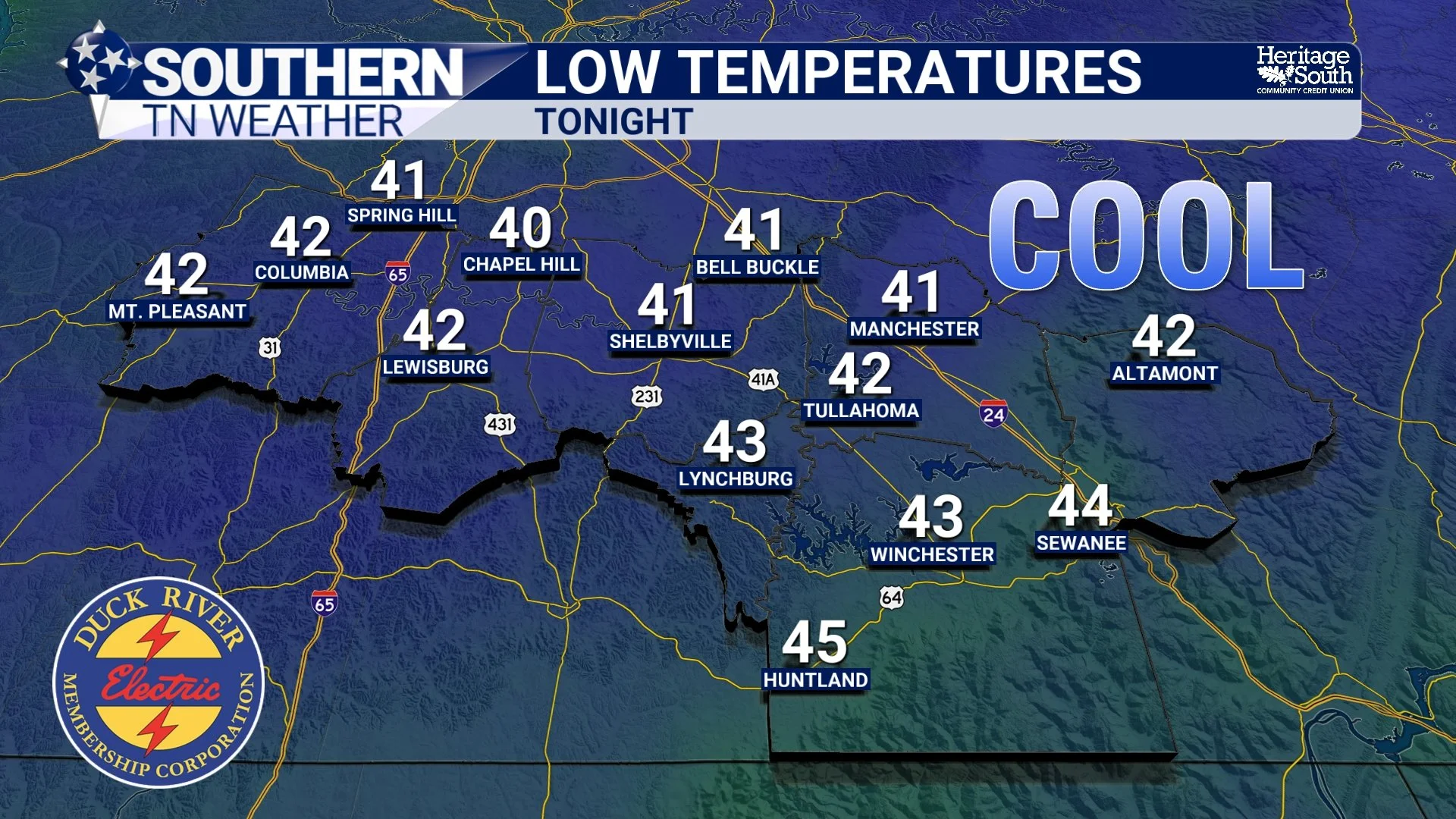
LOW TEMPS - TONIGHT
Friday and Saturday: A Gradual Warm-Up Begins
By Friday afternoon, the center of high pressure shifts eastward, allowing southerly winds to return. That south wind is important because it begins transporting warmer air back into the region. Temperatures Friday will rebound into the low and mid 70s under a mix of sun and clouds, followed by upper 70s to near 80 by Saturday afternoon. Humidity levels will remain fairly manageable overall, so it should still feel comfortable despite the warming trend.
A weak disturbance passing south of the area could try to throw a few isolated showers toward the Tennessee-Alabama border late Friday night into Saturday, but coverage looks very spotty and most communities will remain dry. If you have outdoor plans Friday or Saturday, weather impacts appear minimal overall.
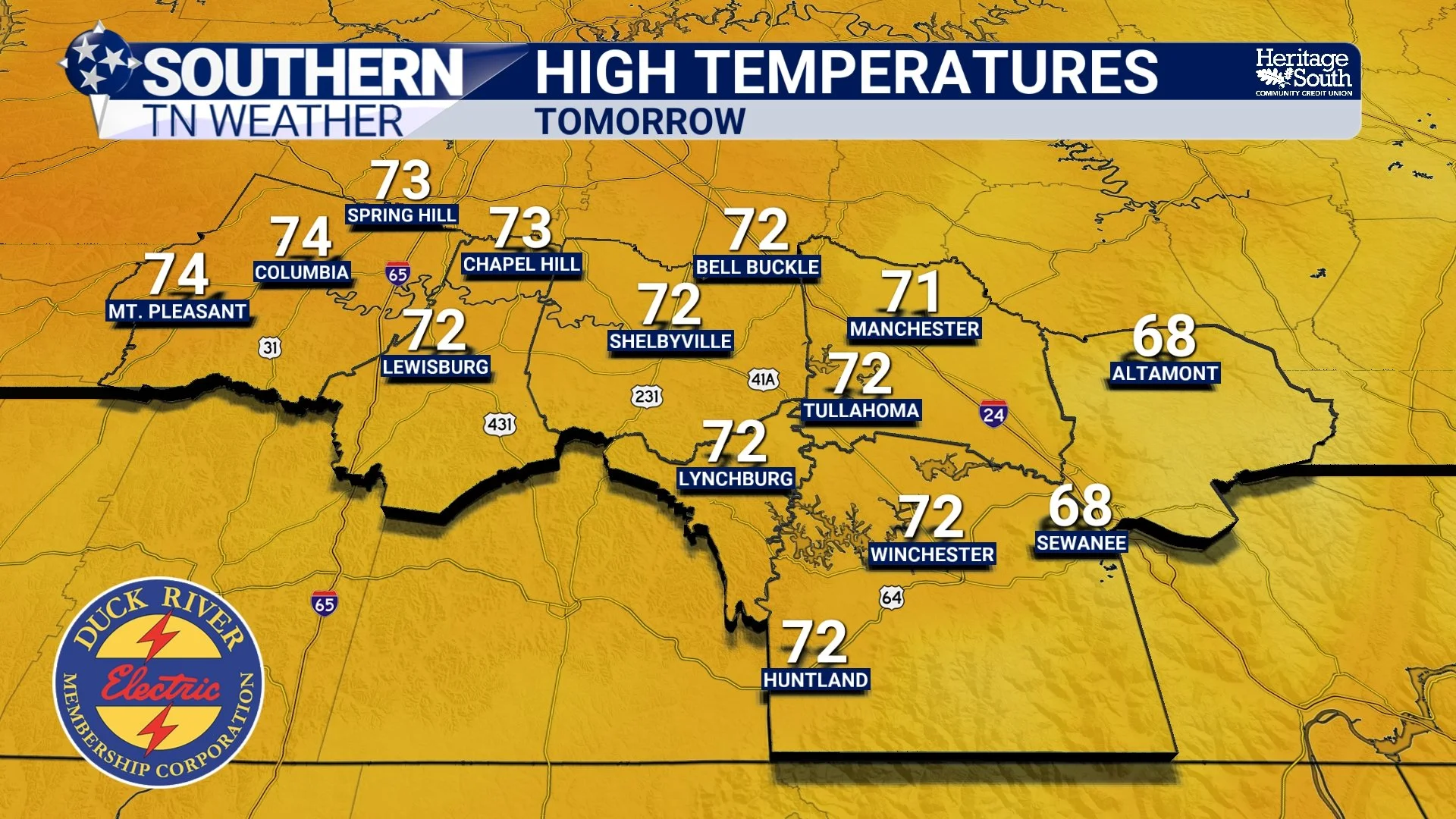
HIGH TEMPS - FRIDAY
Sunday: Rain and Storm Chances Return
The next better opportunity for rain arrives Sunday afternoon into Sunday night as another cold front approaches from the northwest. Unlike the setup earlier this week, this system does not appear particularly moisture-rich or unstable. In meteorology, instability refers to the atmosphere’s ability to support stronger thunderstorm development. While some instability will exist Sunday afternoon, the ingredients for organized severe weather simply do not appear to be in place.
Instead, we’re looking at a fairly typical springtime cold front bringing scattered showers and a few general thunderstorms. Some locations may briefly pick up a decent downpour, especially underneath thunderstorms, but rainfall totals overall look relatively light for most of the region. Current guidance suggests many areas will receive less than a quarter inch of rain, while a few isolated spots under stronger cells could pick up more.
The primary impacts Sunday would simply be:
Brief heavy rainfall
Lightning
Gusty winds in stronger storms
At this time, severe weather is not expected.
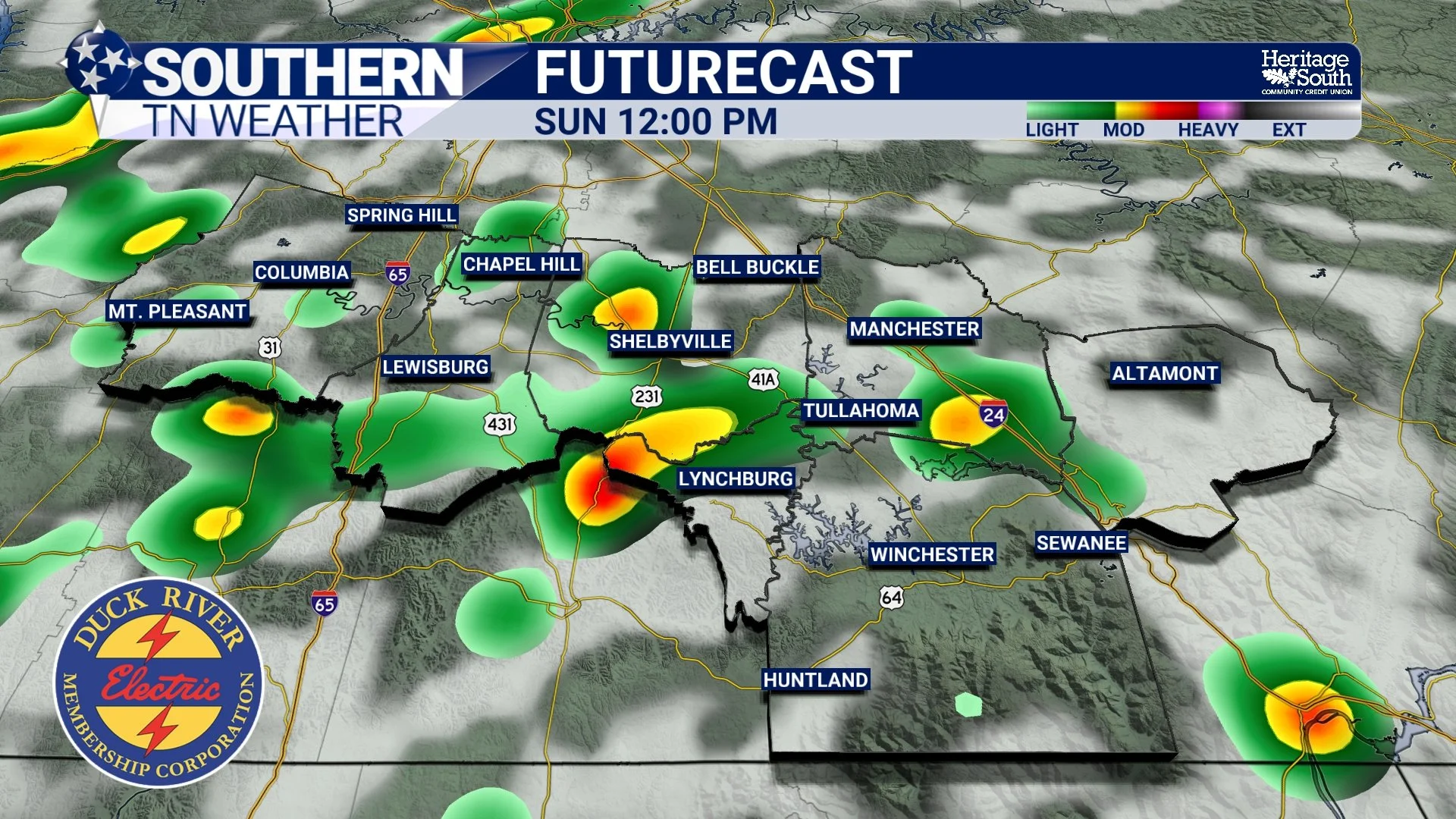
FUTURECAST - SUNDAY AFTERNOON
Early Next Week: Cooler Again
Behind Sunday night’s cold front, another shot of cooler and drier air settles into the region Monday into Tuesday. High temperatures early next week will likely fall back into the 70s, with overnight lows returning to the 40s in some locations. Long-range guidance continues to show a fairly progressive weather pattern, meaning systems continue moving through regularly instead of getting stuck. That usually favors periodic rain chances without long stretches of major severe weather or prolonged flooding concerns.
For now, there are no obvious signs of hazardous weather in the extended forecast.
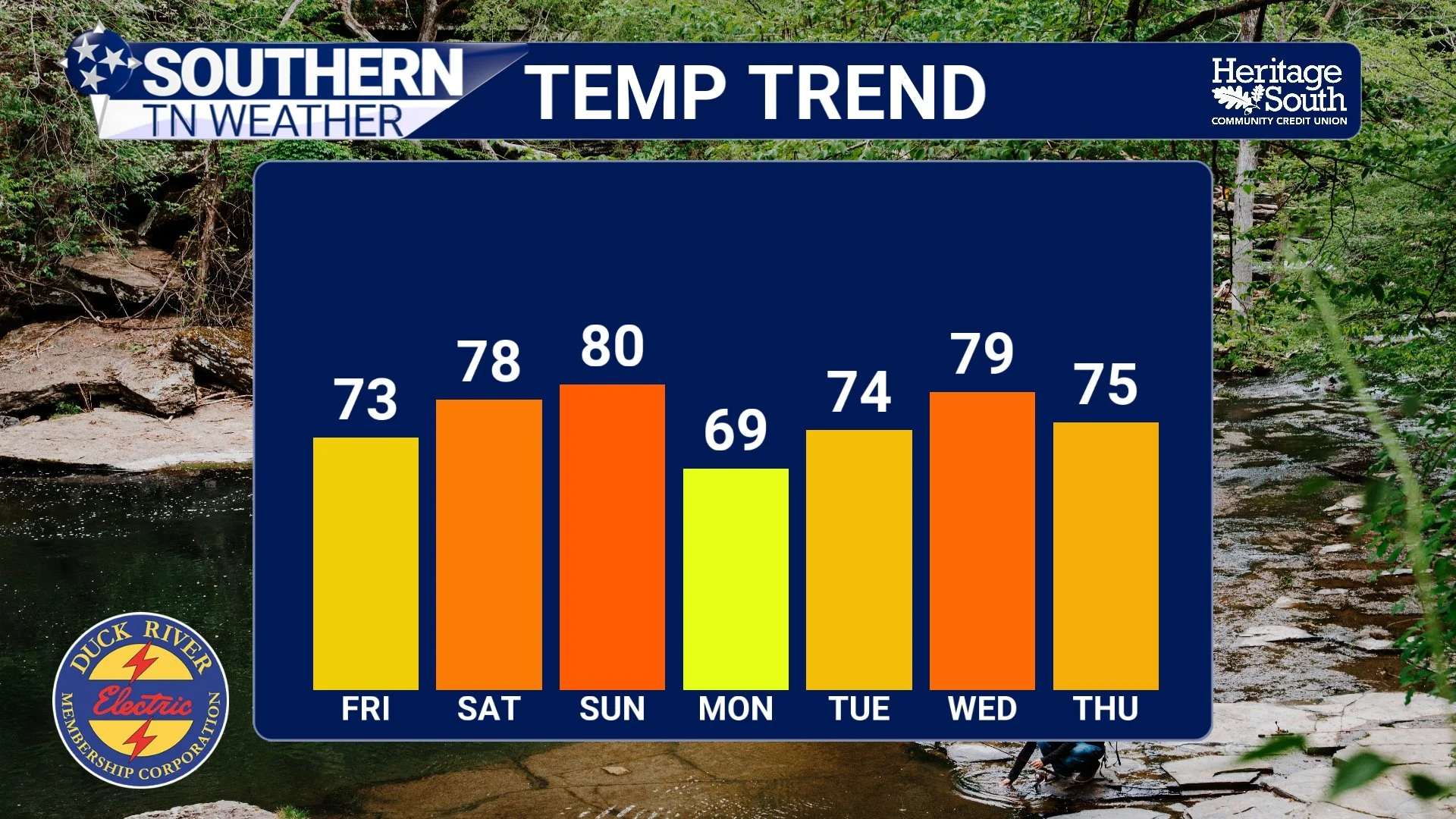
TEMP TREND - NEXT 7 DAYS
The Bottom Line 🧾
Cool, dry weather continues tonight into Friday morning
Patchy fog and isolated light frost possible in colder valleys and Upper Cumberland locations
Warming trend arrives Friday through the weekend
Most of Friday and Saturday stay dry
Scattered showers and storms return Sunday afternoon into early Monday
Severe weather is not expected with the Sunday system
Cooler air returns again early next week
📰 Reminder: The Southern Tennessee Weather Blog, presented by Heritage South Community Credit Union, is updated Monday through Friday with fresh, locally tailored forecasts you can trust.