
El Niño Is Coming Back… What Does That Mean for Us?

The Southern Tennessee Weather Blog is proudly presented by Heritage South Community Credit Union.
We Help When Others Won’t!
Visit https://www.heritagesouth.org/ today to see how HSCCU can help YOU!
After several years dominated by La Niña and neutral conditions, the Pacific Ocean is beginning to show stronger signs that El Niño may develop again later this year. While the phrase “El Niño” gets thrown around constantly in weather coverage, many people don’t fully understand what it actually is… or why water temperatures thousands of miles away in the Pacific Ocean can dramatically influence weather patterns here in Tennessee.
The truth is, El Niño is one of the most important large-scale climate drivers on Earth. It changes the jet stream, shifts storm tracks, alters rainfall patterns, and even affects hurricane activity across the Atlantic Basin. And yes… it absolutely matters here in Southern Middle Tennessee.
What Is El Niño?
El Niño is part of a larger climate cycle known as ENSO, or the El Niño Southern Oscillation. During an El Niño event, sea surface temperatures across the central and eastern tropical Pacific Ocean become warmer than average for an extended period of time. That warmer water changes how heat and moisture are distributed across the atmosphere. Oceans act like fuel tanks for the atmosphere, so when ocean temperatures shift, weather patterns often shift too.
Under normal conditions, strong trade winds push warm water westward toward Asia while allowing cooler water to rise near South America. During El Niño, those trade winds weaken. Warm water spreads farther east across the Pacific, and thunderstorm activity shifts along with it. That change forces the jet stream to reposition itself across North America.
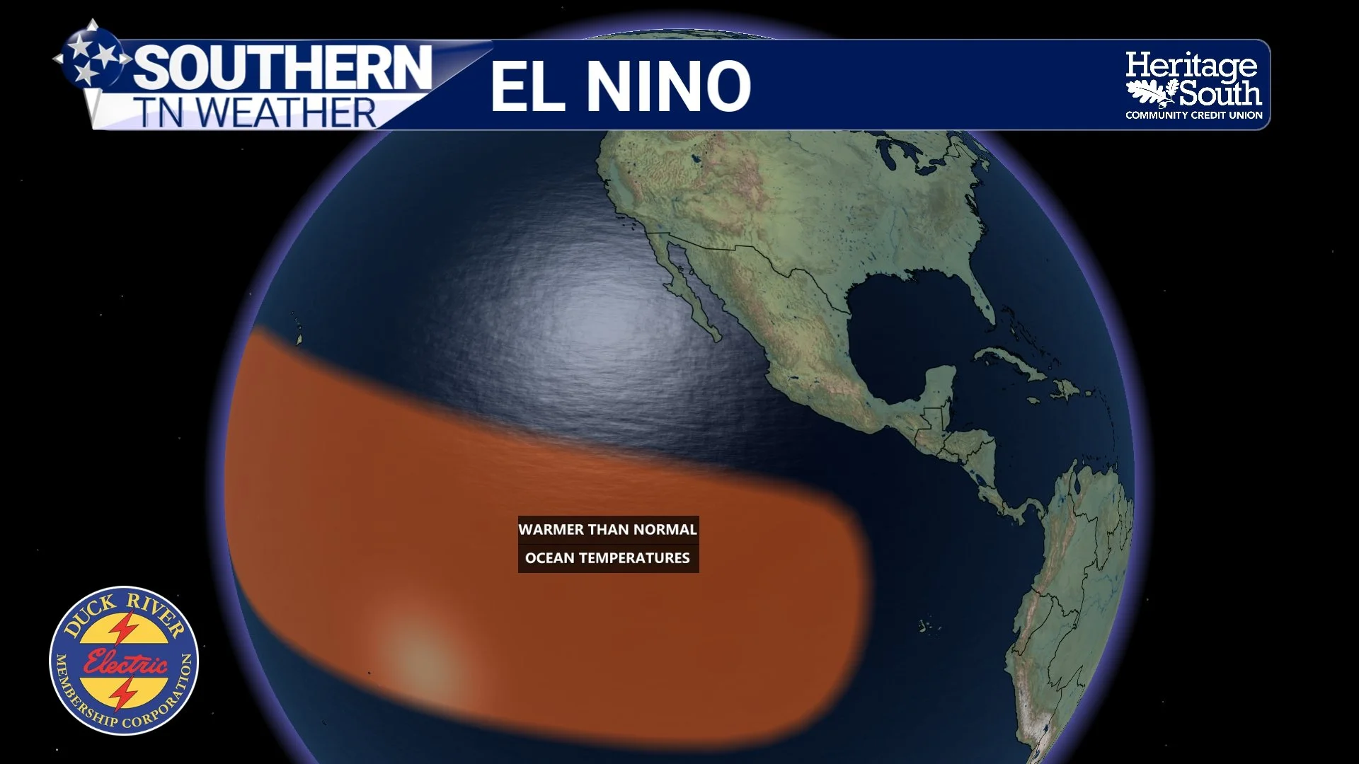
EL NINO
Why the Jet Stream Matters
The jet stream is essentially a fast-moving river of air high in the atmosphere that helps steer storm systems across the globe. During El Niño years, the southern branch of the jet stream often becomes stronger and more active across the southern United States. That typically leads to more storm systems tracking from the Southwest into the Gulf Coast states and Tennessee Valley. Meanwhile, the northern United States often ends up warmer and drier than normal because the storm track shifts farther south.
For Southern Middle Tennessee, El Niño winters are often associated with wetter conditions, more cloud cover, and increased storm activity during the cooler months. That does not mean it rains every single day. It simply means the atmosphere tends to favor a more active southern storm track.
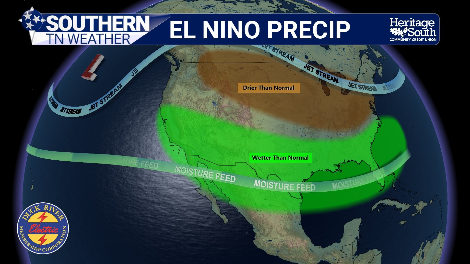
EL NINO PRECIP
The graphic above shows one of the more classic El Niño patterns. Wetter-than-normal conditions often develop across the southern tier of the United States, while drier-than-normal conditions become more common farther north. Tennessee tends to end up near the battle zone between those two air masses, which can lead to active and highly variable weather patterns.
Does El Niño Mean Snow for Tennessee?
This is where people tend to oversimplify things. El Niño does NOT automatically guarantee a snowy winter. What it often does is increase the number of southern-stream storm systems capable of tapping into Gulf moisture. If cold air is present at the same time, winter weather becomes more possible.
Some El Niño winters have brought significant snow and ice storms to Tennessee. Others have produced mostly chilly rain events. The atmosphere has to line up perfectly. You need moisture, lift, and cold air all arriving at the same time. El Niño can help create a favorable large-scale setup for that, but it does not guarantee it.
Severe Weather Can Also Increase
One thing people often overlook is that El Niño can sometimes contribute to active severe weather seasons across the South. A stronger southern jet stream often means stronger wind shear across the Tennessee Valley. Wind shear is the change in wind speed and direction with height, and it is one of the key ingredients needed for organized severe thunderstorms and tornadoes.
That does not mean El Niño guarantees tornado outbreaks here. But it can help create atmospheric setups that are more supportive of strong storm systems moving across the Southeast during winter and spring. For Southern Middle Tennessee, that can sometimes mean an increased number of heavy rain events, squall lines, and severe weather setups during the cooler season.
El Niño and Hurricanes
One of the more fascinating parts of El Niño is how it often suppresses Atlantic hurricane activity. During El Niño, stronger upper-level winds develop across portions of the Atlantic Basin. Those winds create what meteorologists call wind shear, which tears apart developing tropical systems before they can organize efficiently. Wind shear is great for severe thunderstorms on land… but not good for hurricanes. Meanwhile, hurricane activity in the eastern Pacific often increases because conditions there become more favorable.
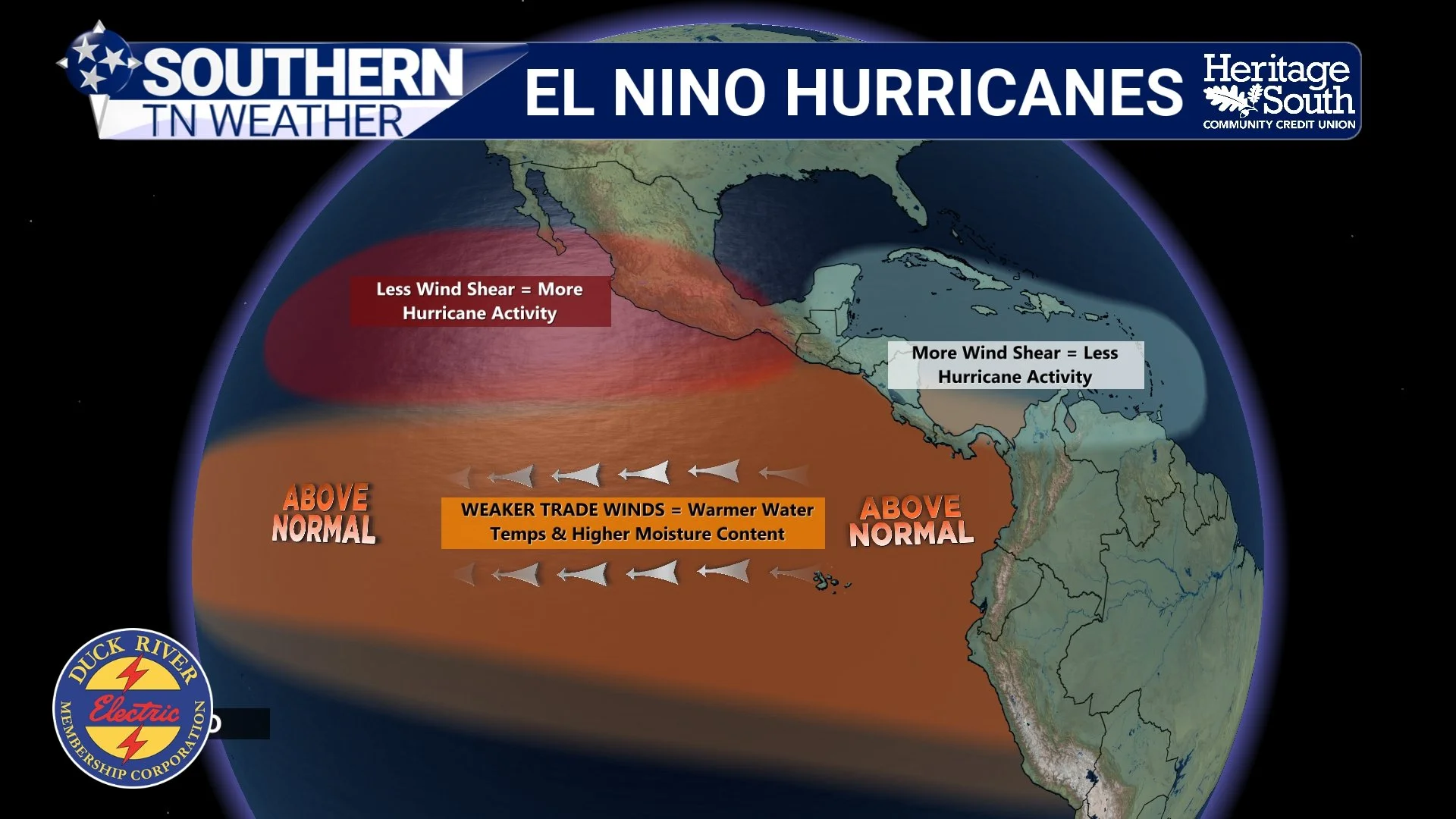
EL NINO HURRICANES
This does NOT mean the Atlantic suddenly becomes inactive. It only takes one hurricane to create a disaster. But historically, stronger El Niño years often correlate with somewhat lower Atlantic hurricane activity overall.
How Strong Could This El Niño Become?
Ocean temperatures across portions of the tropical Pacific are already warming, and many long-range forecast models continue showing additional warming through summer and into fall. However, the strength of an El Niño event matters tremendously. A weak El Niño behaves much differently than a strong one. Atmospheric patterns also do not respond instantly. The ocean may warm first, while the atmosphere takes weeks or even months to fully react.
That is why meteorologists focus heavily on trends and probabilities instead of guarantees. Weather and climate are fluid sciences. The atmosphere is constantly evolving.
What This Could Mean for Southern Middle Tennessee
If El Niño continues strengthening later this year, it would likely favor a more active southern storm track across the Southeast. That could increase opportunities for rainfall, stronger winter storm systems, and periodic severe weather episodes heading into late 2026 and early 2027. For drought conditions, that may actually be beneficial. More frequent storm systems could help improve soil moisture and water supplies across the region.
At the same time, a more active pattern can also mean greater severe weather opportunities and larger temperature swings. As always, local impacts depend on much smaller atmospheric details that cannot be nailed down months in advance.
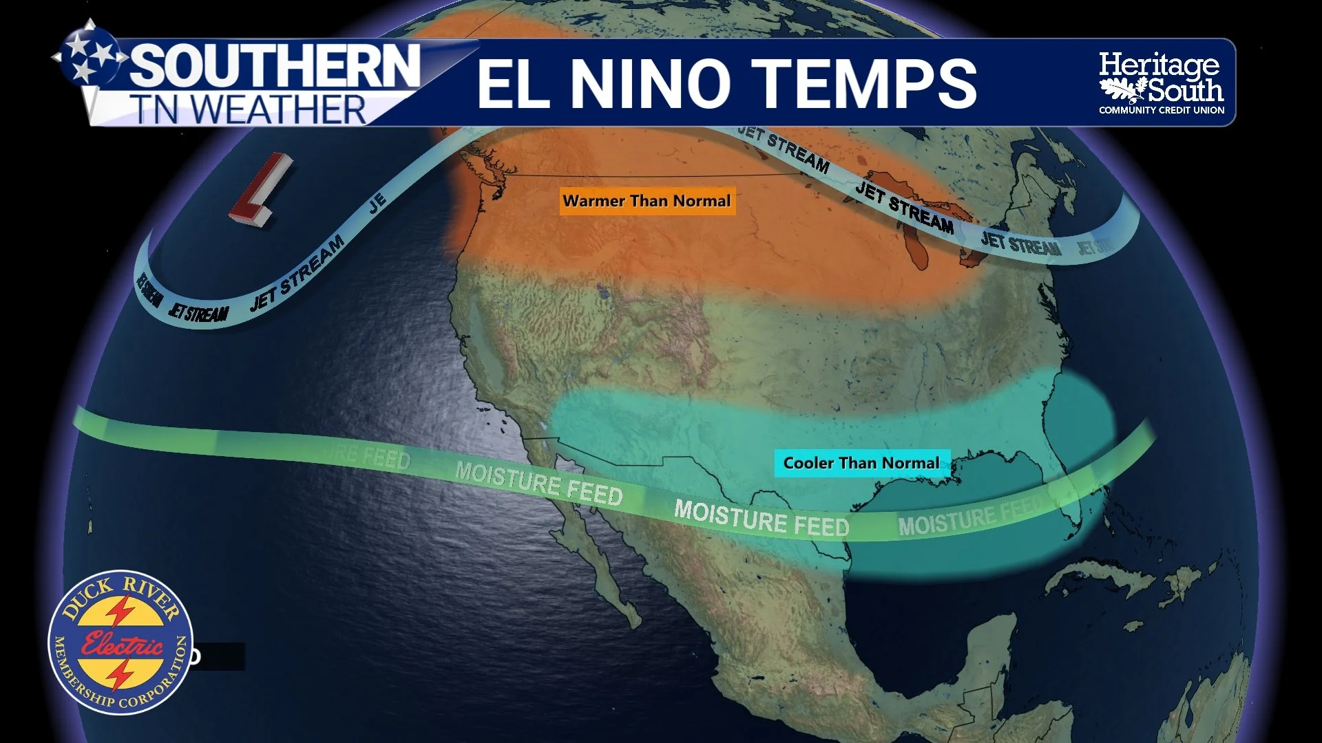
EL NINO TEMPS
The Bottom Line 🧾
El Niño is a warming of the tropical Pacific Ocean that changes weather patterns across the globe.
El Niño often strengthens the southern jet stream and increases storm systems across the southern United States.
Southern Middle Tennessee typically sees wetter and more active weather patterns during El Niño years.
El Niño can increase opportunities for heavy rain and severe weather setups during winter and spring.
El Niño does NOT automatically guarantee snow for Tennessee.
Atlantic hurricane activity is often somewhat lower during El Niño years because of stronger wind shear.
Forecast trends strongly suggest El Niño may continue developing through the rest of 2026.
📰 Reminder: The Southern Tennessee Weather Blog, presented by Heritage South Community Credit Union, is updated Monday through Friday with fresh, locally tailored forecasts you can trust.