
Warm Today, Light Rain Tonight, Heavier Rain Possible This Weekend

The Southern Tennessee Weather Blog is proudly presented by Heritage South Community Credit Union.
We Help When Others Won’t!
Visit https://www.heritagesouth.org/ today to see how HSCCU can help YOU!
Southern Middle Tennessee is enjoying one more unseasonably warm day, but changes are already lining up as we head into tonight and the rest of the week. While today feels more like late March than early February, a cold front moving in this evening will bring a round of light rain, followed by cooler (though not dramatically colder) and drier conditions for the middle of the week. The bigger story unfolds after that, as the pattern turns more active heading into the weekend with the potential for heavier rainfall.
Today: Springlike Warmth Holds On
As of midday, temperatures across Southern Middle Tennessee are already well into the 60s, and many locations will push into the low 70s this afternoon. This places us well above normal for early February and continues the brief stretch of springlike weather that began over the weekend. Skies remain partly to mostly cloudy, but cloud cover will do little to limit warming thanks to strong warm air advection ahead of an approaching cold front.
Southwest winds will remain noticeable through the afternoon, generally in the 5 to 10 mph range with occasional gusts between 15 and 20 mph. This warmth will not last, so it is a good day to enjoy being outdoors before conditions change tonight.
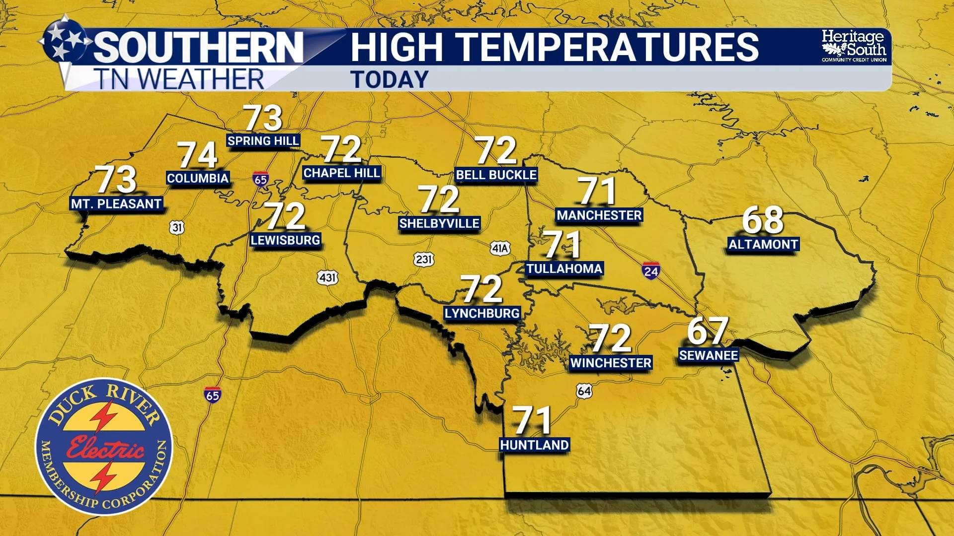
HIGH TEMPERATURES - TODAY
Tonight into Wednesday: Light Rain, Then Cooler and Drier
A weak cold front moves through Southern Middle Tennessee late tonight into early Wednesday morning. As it does, light rain will overspread the area, with most locations picking up between a quarter and a half inch of rainfall. This will be a steady, light rain rather than anything intense. Atmospheric instability is very limited, so thunder chances are extremely low and no severe weather is expected.
The most likely window for rainfall locally is between midnight and around 6 AM, give or take a few hours. Rain should taper off by late Wednesday morning as the front moves east of the area. Behind it, cooler and drier air settles in. Temperatures on Wednesday fall back closer to seasonal norms, with highs in the upper 50s to lower 60s. Skies gradually clear through the day, and Wednesday night feels noticeably cooler, with lows dropping into the 30s.
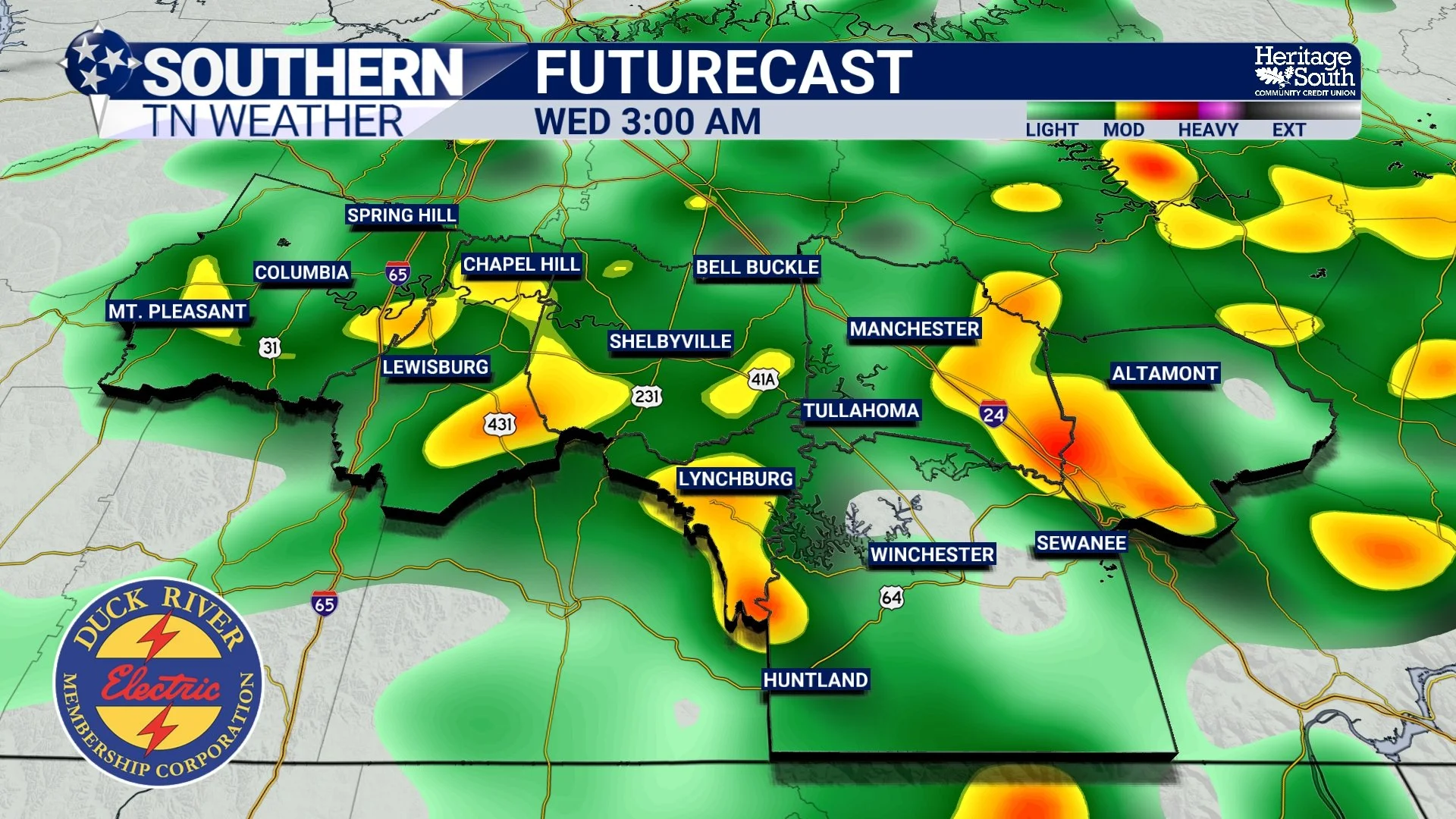
FUTURECAST - EARLY WEDNESDAY MORNING
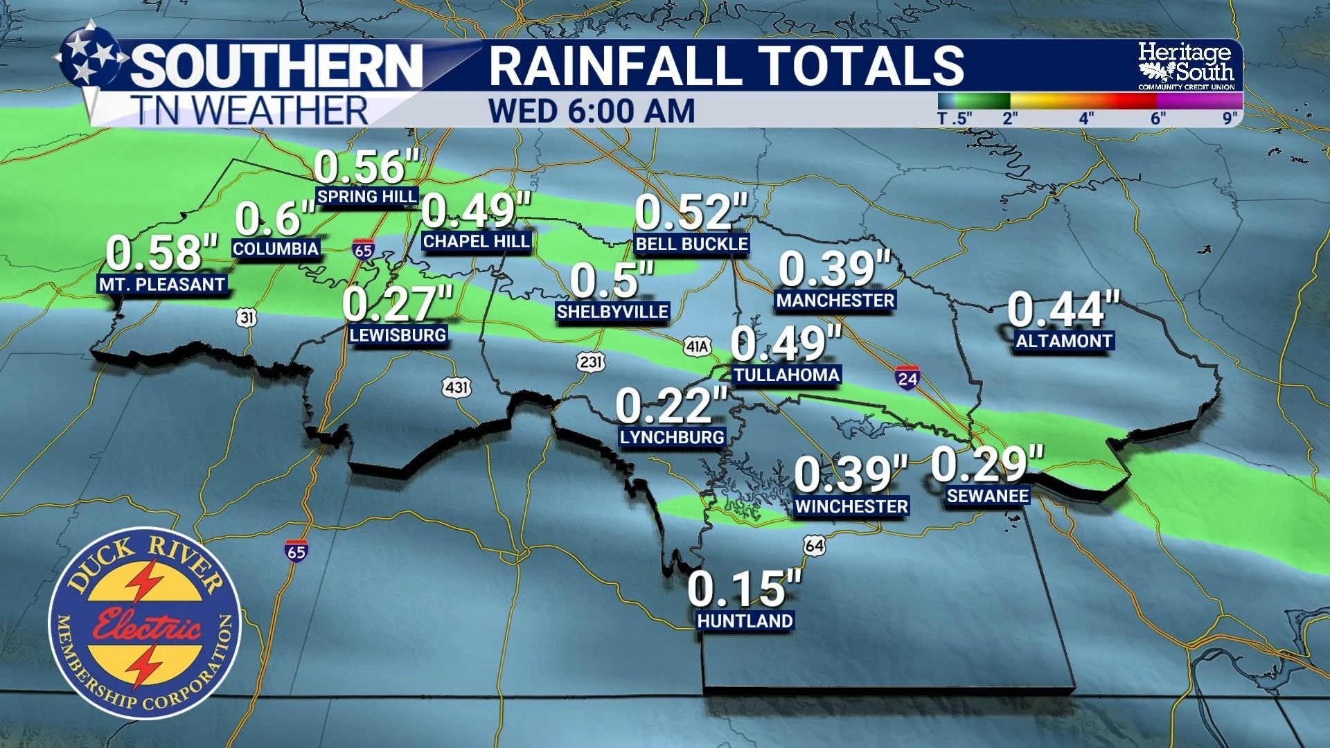
RAINFALL TOTALS - TONIGHT INTO WEDNESDAY
Midweek: Quiet, but a Bit Cooler
Thursday looks quiet and dry across Southern Middle Tennessee. Northwest flow aloft reinforces the cooler air mass, keeping highs in the upper 50s to near 60 degrees. With clear skies, light winds, and lingering ground moisture from earlier rainfall, patchy fog is possible early Thursday morning. Overall, however, conditions remain calm and uneventful.
Looking Ahead: Rain Chances Increase This Weekend
Attention then turns to the weekend, when a more dynamic system is expected to move east out of the Plains. Forecast guidance continues to show increasing rain chances late Friday night through Saturday, with rain likely continuing at times into Sunday. This system has the potential to produce heavier rainfall, especially if thunderstorms become involved.
Rainfall amounts are still highly uncertain at this range. Current model guidance ranges from around a half inch to more than two inches across parts of Middle Tennessee. Because of that spread, confidence in exact totals remains low, but the signal for a wetter weekend is becoming clearer. Severe weather does not appear likely at this time, but localized heavier rain could lead to ponding on roads and rises on creeks and streams if higher-end totals materialize. Temperatures through the weekend remain mild, with highs generally in the 50s and 60s and overnight lows in the 30s and 40s.
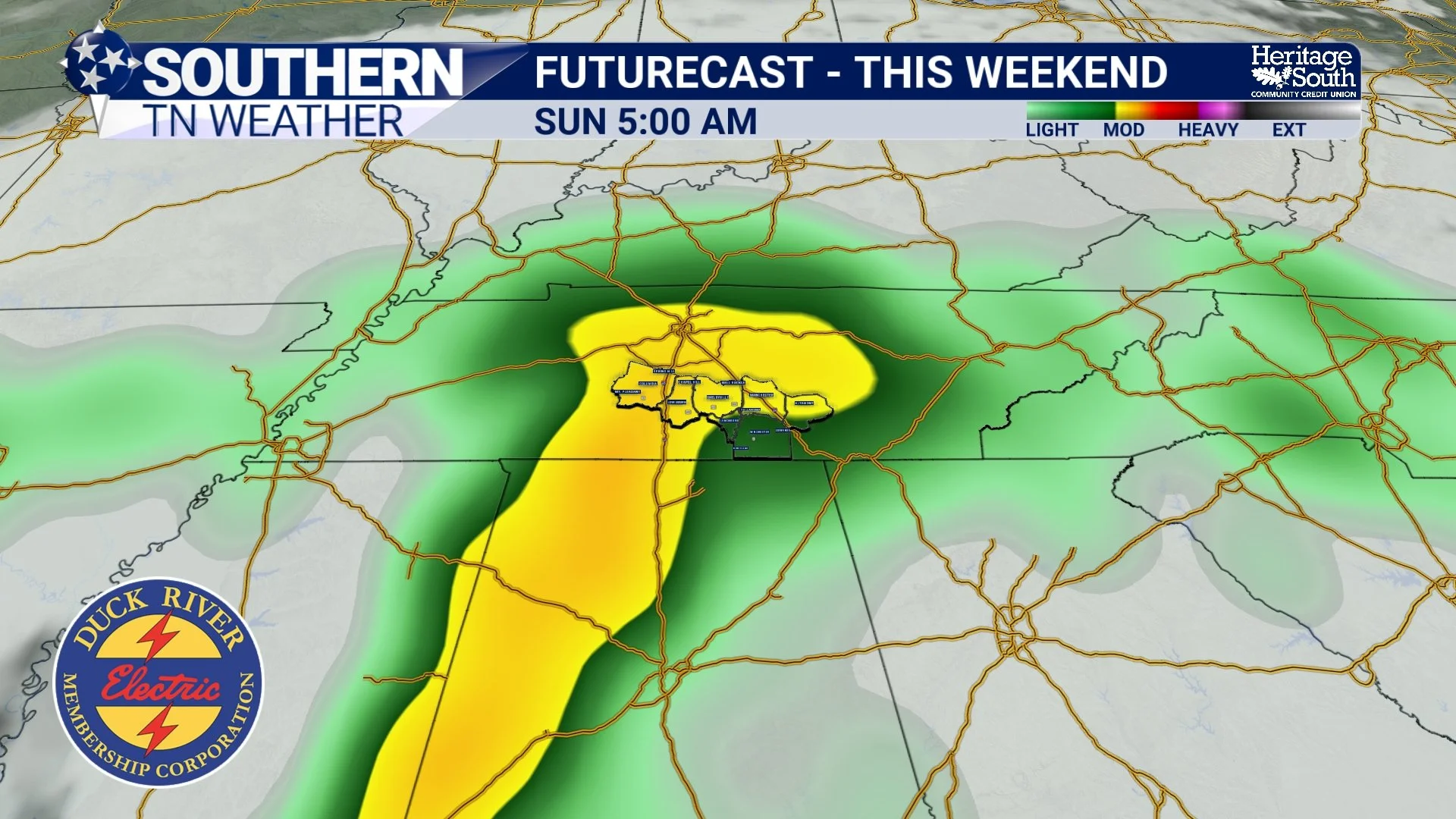
FUTURECAST - THIS WEEKEND
The Bottom Line 🧾
• Warm and springlike conditions continue through this afternoon
• Light rain moves in tonight with totals generally under 0.50"
• Cooler, drier air arrives Wednesday and Thursday
• Midweek weather stays quiet with near-normal temperatures
• Rain chances increase late Friday into the weekend
• Heavier rainfall is possible this weekend, but details are still uncertain
📰 Reminder: The Southern Tennessee Weather Blog, presented by Heritage South Community Credit Union, is updated Monday through Friday with fresh, locally tailored forecasts you can trust.