
Springlike Warmth Peaks Before Rain Returns

The Southern Tennessee Weather Blog is proudly presented by Heritage South Community Credit Union.
We Help When Others Won’t!
Visit https://www.heritagesouth.org/ today to see how HSCCU can help YOU!
Southern Middle Tennessee is firmly in a springlike pattern as we head into the start of the workweek, with unusually warm temperatures today and Tuesday before a return to rain and a modest cool-down midweek. While winter has made plenty of appearances over the past several weeks, the atmosphere is now taking a very different turn, and the next few days will feel far more like late March than early February. This forecast is defined by three main phases: near-record warmth through Tuesday, a quick-moving rain event Tuesday night into Wednesday, and increasing uncertainty heading into the weekend as rain chances return.
Today and Tuesday: Unseasonably Warm, Near Records Possible
Strong upper-level ridging remains in place across much of the central and eastern United States, allowing warm air to surge northward into Southern Middle Tennessee. Sunshine and efficient warm air advection are already pushing temperatures well above normal this afternoon, with highs climbing into the upper 60s and lower 70s across much of the area. Tuesday looks even warmer. Forecast highs approach the low 70s, and that puts us very close to daily record territory. For reference, the daily record high at Shelbyville is 74 degrees, set back in 1954. While not everyone will hit record values, several locations across Southern Middle Tennessee may come very close, and some could briefly touch the mid 70s.
Winds will increase slightly from the southwest through Tuesday, with sustained speeds around 10 mph and occasional gusts near 20 mph. Skies will remain mostly sunny today, but clouds will increase Tuesday ahead of an approaching cold front. Despite the cloud cover, temperatures will remain mild thanks to continued warm air transport.
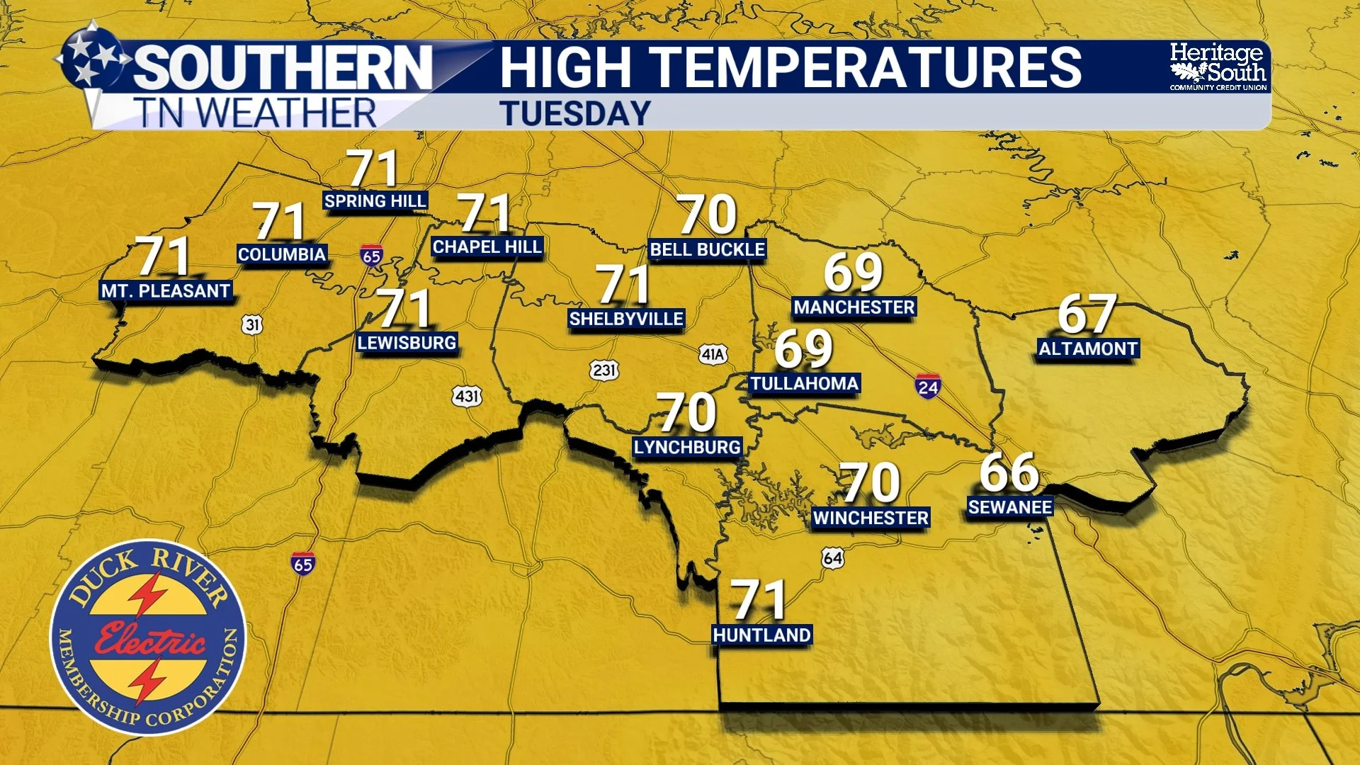
HIGH TEMPERATURES - TUESDAY
Tuesday Night into Wednesday: Rain Moves Through, No Winter Concerns
A weak cold front will push southeast into Southern Middle Tennessee Tuesday evening and overnight. Ahead of the front, moisture increases and rain chances rise quickly. Rain is expected to develop late Tuesday evening and continue through the overnight hours into early Wednesday. Rainfall totals will generally range from around a quarter inch to one-half inch, with locally higher totals possible in spots. While some guidance suggests a very small amount of elevated instability (storm fuel) near daybreak Wednesday, the overall environment remains unfavorable for thunderstorms. Any thunder chance is very low, and severe weather is not expected.
The rain will move through efficiently, with most locations drying out by late Wednesday morning or early afternoon. Importantly, the colder air arrives after the precipitation exits, so there are no concerns for wintry weather with this system. Temperatures will trend cooler behind the front, with highs on Wednesday falling back into the 50s and overnight lows dipping into the 30s.
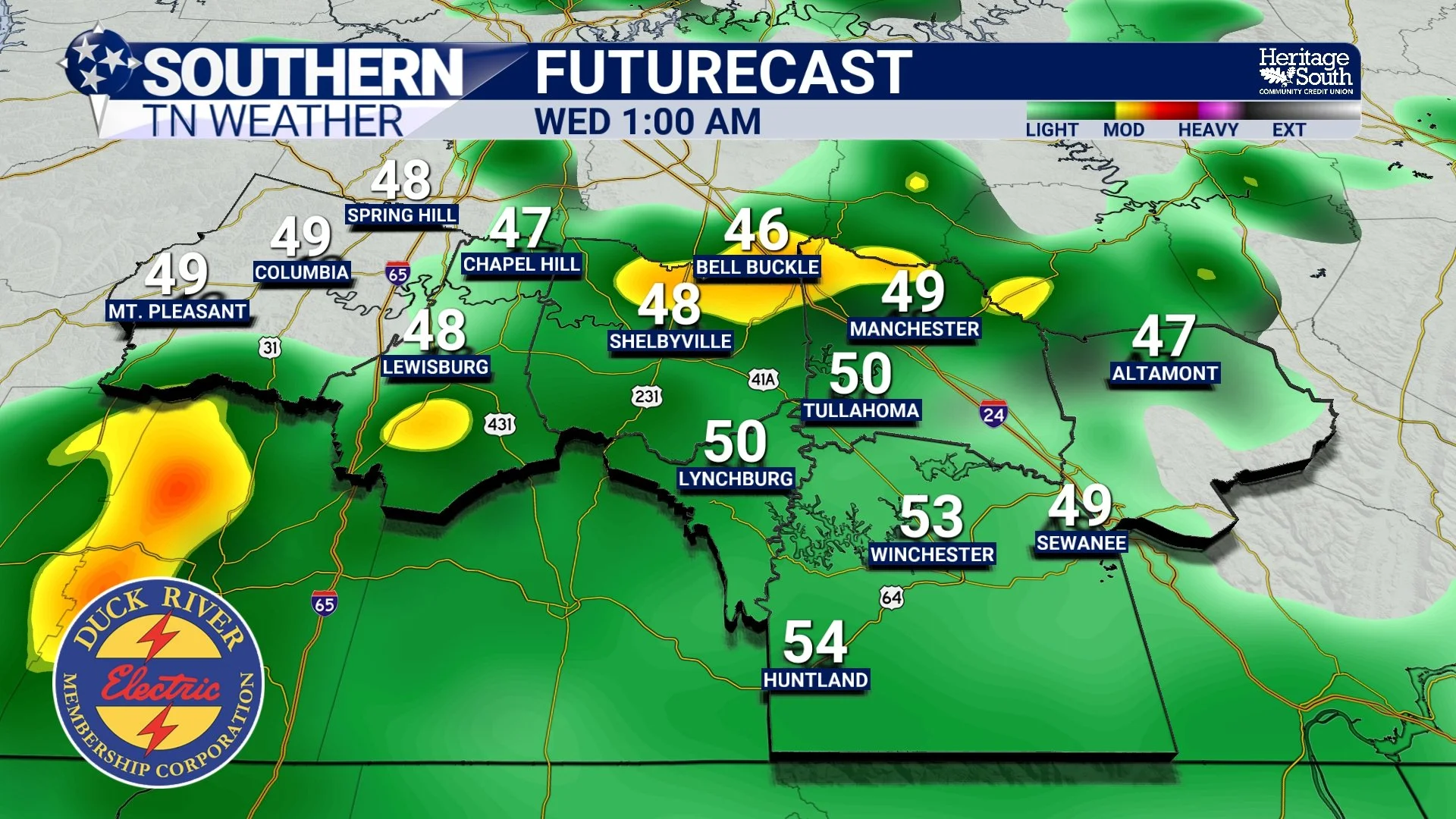
FUTURECAST - WEDNESDAY MORNING
Midweek: Mild, Mostly Dry, and Seasonable
Behind Wednesday’s rain, the pattern briefly settles down. Thursday looks mostly dry with highs in the mid to upper 50s and cooler mornings in the 30s. While this is a step down from the early-week warmth, temperatures remain near or slightly above average for early February. This midweek period offers a break from precipitation and a transition toward the next weather feature.
Late Week into the Weekend: Rain Chances Return, Details Uncertain
Attention then turns to late Friday and the weekend, when rain chances increase once again. Multiple shortwaves are expected to move through the broader pattern, and while confidence is growing that rain returns, the exact timing, coverage, and intensity remain uncertain. Some model solutions suggest a more organized system that could bring widespread rain, while others favor a weaker, more progressive setup with intermittent showers. At this time, rainfall amounts do not appear excessive, and there are no strong signals for flooding concerns. However, the forecast will need refinement as we move closer to the weekend.
Temperatures during this time remain relatively mild, with highs generally in the 50s to near 60, depending on cloud cover and rain timing.
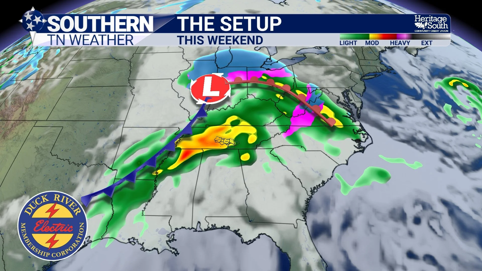
THE SETUP - THIS WEEKEND
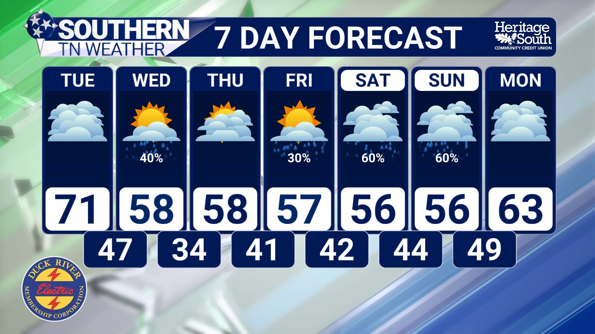
STNWX 7 DAY FORECAST
The Bottom Line 🧾
• Springlike warmth continues today and Tuesday
• Highs reach the upper 60s to low 70s, with near-record temperatures possible Tuesday
• Increasing clouds Tuesday ahead of a weak cold front
• Rain moves in late Tuesday evening and continues into early Wednesday
• Rainfall generally ranges from 0.25" to 0.50", with locally higher amounts possible
• Cooler, seasonable temperatures return midweek with highs in the 50s
• Rain chances increase again late Friday into the weekend, though details remain uncertain
📰 Reminder: The Southern Tennessee Weather Blog, presented by Heritage South Community Credit Union, is updated Monday through Friday with fresh, locally tailored forecasts you can trust.