
Dry for Now, Rainy Conditions Return This Weekend

The Southern Tennessee Weather Blog is proudly presented by Heritage South Community Credit Union.
We Help When Others Won’t!
Visit https://www.heritagesouth.org/ today to see how HSCCU can help YOU!
Southern Middle Tennessee is settling into a brief stretch of quieter weather today, but the atmosphere is far from finished with us. After yesterday’s record-setting warmth, a cooler and drier pattern takes hold through the end of the workweek. Attention then turns to the weekend, when a more organized storm system brings a high likelihood of widespread rainfall across the region. While flooding is not expected at this time, this system will mark a clear shift back toward a wetter pattern.
Today and Thursday: Cooler, Drier, and Stable
Behind yesterday’s cold front, Southern Middle Tennessee is now under northwesterly flow aloft. In simple terms, this means winds higher up in the atmosphere are coming from the northwest, which typically brings in cooler and drier air. Lingering clouds and a few light showers have exited southern portions of the area this morning, and sunshine is becoming more dominant as high pressure builds in from the west.
High pressure refers to sinking air in the atmosphere, which suppresses cloud formation and precipitation. As this system settles overhead, conditions turn quiet and stable. Afternoon temperatures today will be noticeably cooler than Tuesday, but still seasonable for mid-February. Tonight, clear skies and lighter winds allow temperatures to fall into the 20s and 30s. Thursday continues this trend. High pressure remains in control, keeping skies mostly sunny and precipitation-free. We will see an increase in cloud cover as the day goes on, though… Temperatures stay on the cool side, but this is not an Arctic air mass. By Thursday night, winds begin to shift, signaling the next change in the pattern.
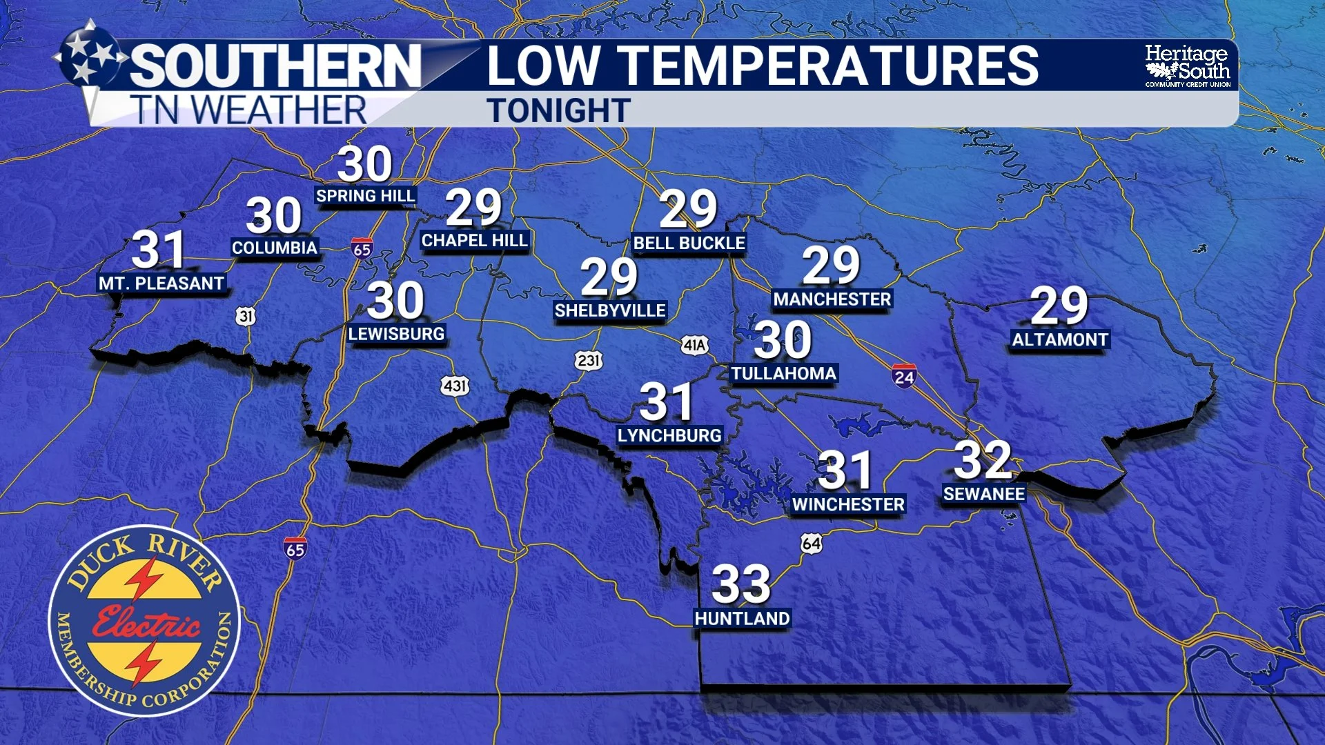
LOW TEMPERATURES - TONIGHT
Friday: Transition Day with a Warm-Up Beginning
By Friday, the weather begins to turn a corner. A shortwave ridge, which is essentially a zone of slightly higher pressure aloft, moves into the region. This allows warmer air to advect, or flow, northward into Southern Middle Tennessee. Highs rebound into the 60s, and humidity levels slowly begin to increase. While Friday remains dry, it sets the stage for what comes next.
Saturday and Sunday: Widespread Rain Likely
The primary weather story of the upcoming forecast centers on the weekend. A southern-stream disturbance currently off the California coast is forecast to move into the Southern Plains and Lower Mississippi Valley on Saturday. As this system approaches, southerly winds near the surface draw in higher moisture content, measured by a parameter called precipitable water (PW). Higher PW values indicate a more moisture-rich atmosphere capable of producing widespread rainfall.
Rain chances increase sharply Saturday morning and remain high through Sunday afternoon. Current guidance supports storm-total rainfall amounts of 1 to 2 inches across Southern Middle Tennessee. Importantly, the surface low associated with this system is expected to track south of our area. Because of that, atmospheric instability remains very low to nonexistent locally. Instability is what fuels thunderstorms, and its absence means storms should stay mostly stratiform, or steady rain, rather than strong convection. This lack of deep thunderstorms significantly limits the flooding risk despite the fairly healthy rainfall totals. At this time, flooding is not expected, though ponding of water in low-lying or poor-drainage areas will be possible during heavier periods of rain. The wettest window currently appears to be Saturday night into early Sunday.
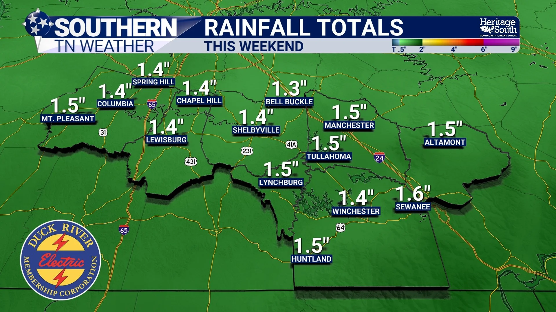
RAINFALL TOTALS (NBM) - THIS WEEKEND
Early Next Week: Brief Cool-Down, Then Above-Normal Temperatures
As the weekend system exits Sunday night, a short-lived push of cooler air moves in. This cold advection, or transport of cooler air, will not last long. Global models and ensemble guidance strongly favor renewed ridging early next week, which allows warmer air to return quickly. By Monday afternoon through midweek next week, temperatures climb back to above-normal levels, with highs in the 60s and potentially low 70s. Overnight lows also moderate into the 40s and 50s, signaling a more springlike regime returning to the region.
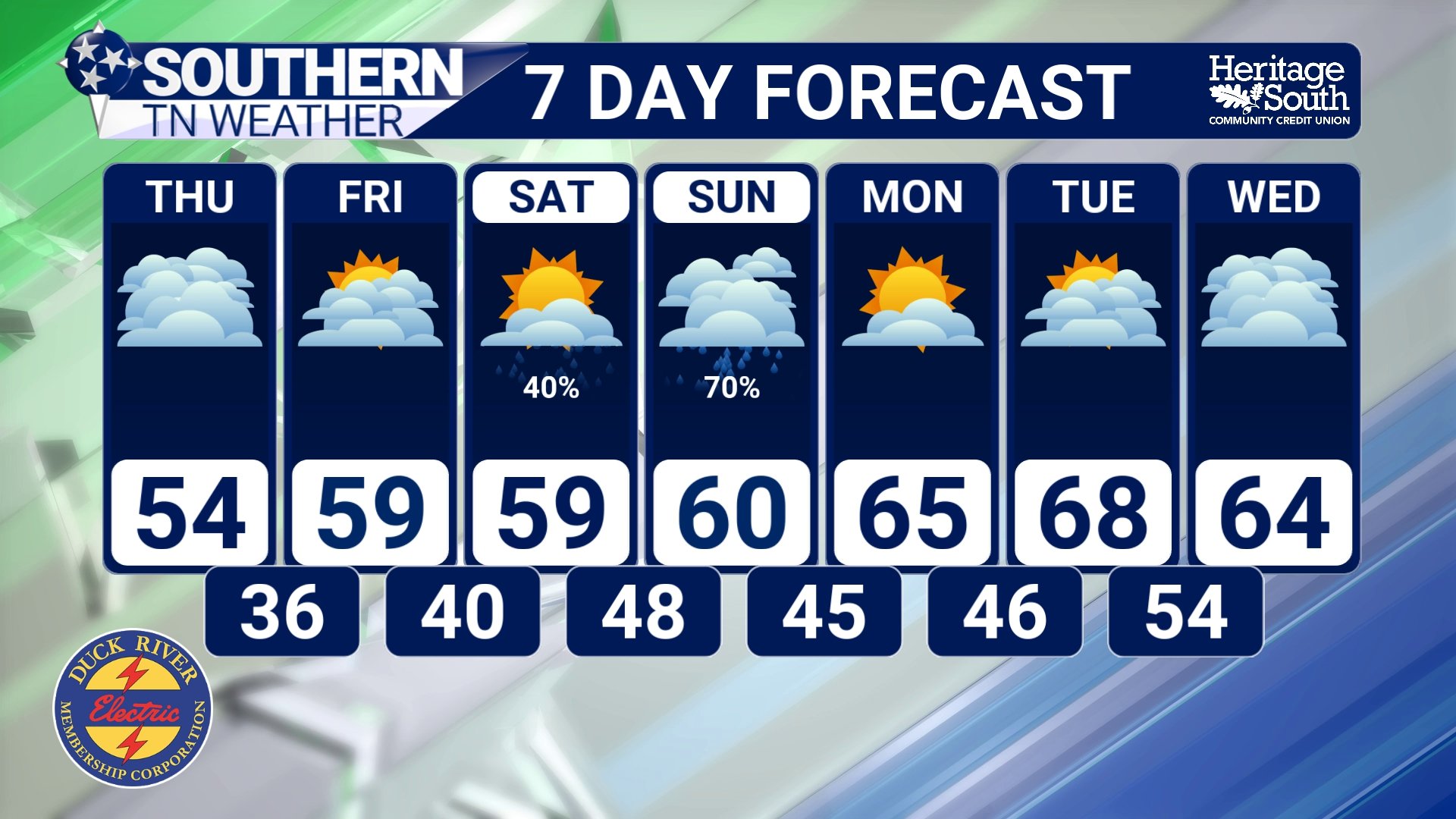
STNWX 7-DAY FORECAST
The Bottom Line 🧾
• High pressure keeps conditions quiet today and Thursday
• Temperatures warm into the upper 50s and low 60s on Friday
• Widespread rain is likely Saturday through Sunday
• Storm-total rainfall of 1–2 inches is expected
• Flooding is not anticipated at this time
• Above-normal temperatures return early next week
📰 Reminder: The Southern Tennessee Weather Blog, presented by Heritage South Community Credit Union, is updated Monday through Friday with fresh, locally tailored forecasts you can trust.