
Warm and Cloudy Now — A Holiday Warmth Peak Before a Sharp Pattern Flip

The Southern Tennessee Weather Blog is proudly presented by Heritage South Community Credit Union.
We Help When Others Won’t!
Visit https://www.heritagesouth.org/ today to see how HSCCU can help YOU!
It doesn’t feel very Christmas-like outside today, and that’s no accident. Southern Middle Tennessee remains locked in a warm, moist pattern as southerly winds continue to feed mild air into the region. Temperatures are running well above average, cloud cover has been stubborn, and occasional light showers are drifting through the area.
While it may feel stormy outside, this is not a hazardous setup. Instead, this forecast is about timing and perspective — enjoying an unusually warm holiday stretch while keeping an eye on a much colder pattern waiting just beyond it.
Today and Christmas Eve: Warm, Cloudy, and Occasionally Damp
Low clouds and spotty light showers will continue on and off through today and into Christmas Eve. These showers are being driven by weak disturbances moving through a moist air mass rather than any organized storm system. Rainfall will be very light and hit-or-miss. Many locations will stay completely dry, and those that do see rain will likely measure only a few hundredths of an inch. This is more of a “damp at times” forecast than a true rain event.
Temperatures remain the bigger story. Highs today and Wednesday will stay in the mid to upper 60s, well above normal for late December. Overnight lows remain mild as well, generally holding in the 50s.
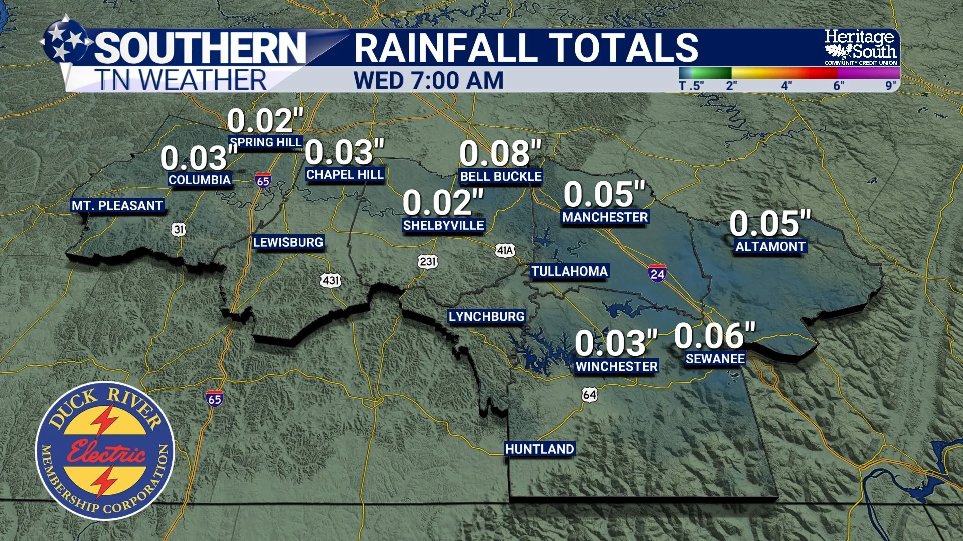
Rainfall Totals - Next 24 Hours
Christmas Day: Warm, Breezy, and Mostly Dry
Christmas Day continues to look unseasonably warm across Southern Middle Tennessee. High temperatures will climb into the upper 60s to low 70s, roughly 15 to 20 degrees above average. Cloud cover will likely stick around for much of the day, and a steady breeze may develop at times, but travel impacts are not expected. While a weak disturbance passes nearby, most locations should remain dry.
For context, record highs on Christmas Day across Middle Tennessee are generally in the mid to upper 70s. While we likely fall just short of those records, this will still be one of the warmer Christmas days many of us can remember.
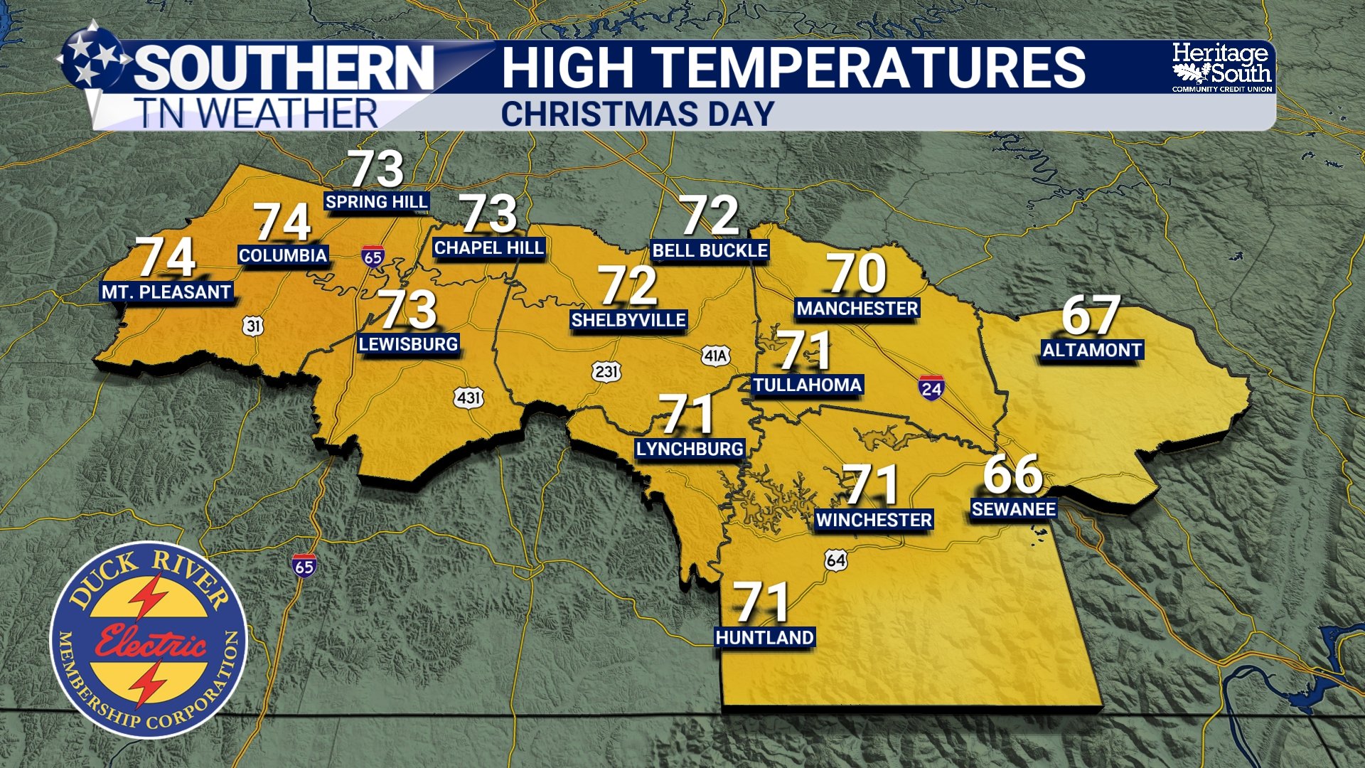
Christmas Day Temperatures
Friday and Saturday: The Warmest Stretch
If you enjoy warm weather, Friday and Saturday are the days to take advantage of it. As upper-level ridging strengthens overhead, temperatures will peak, with highs pushing into the low to mid 70s by Saturday. Rmember, a ridge means high pressure and fair weather… This will likely be the warmest day of the entire stretch and the most spring-like weather we’ll see during the holiday period.
Skies will remain partly to mostly cloudy, but rain chances stay very low through Saturday.
Sunday into Monday: The Pattern Flip
of course, our warm pattern cannot (and will not) last. A stronger cold front is expected to move through sometime Sunday into early Monday. While exact timing is still being refined, confidence is increasing in a widespread rain event followed by a sharp temperature drop.
Moisture levels ahead of this front will be high, so rain coverage looks widespread. Current projections generally range from about a quarter to half an inch of rainfall, though isolated higher amounts remain possible. Severe weather does not appear likely at this time due to limited instability but it’s something to watch. Once the front passes, temperatures will fall quickly.
By Monday morning, many locations could wake up to lows in the low to mid 20s — a drop of 30 degrees or more compared to the weekend highs. Any lingering precipitation should be ending as the colder air arrives, though a few flurries can’t be ruled out well northeast of our area. Highs on Monday will struggle to get out of the 30s for most of us.
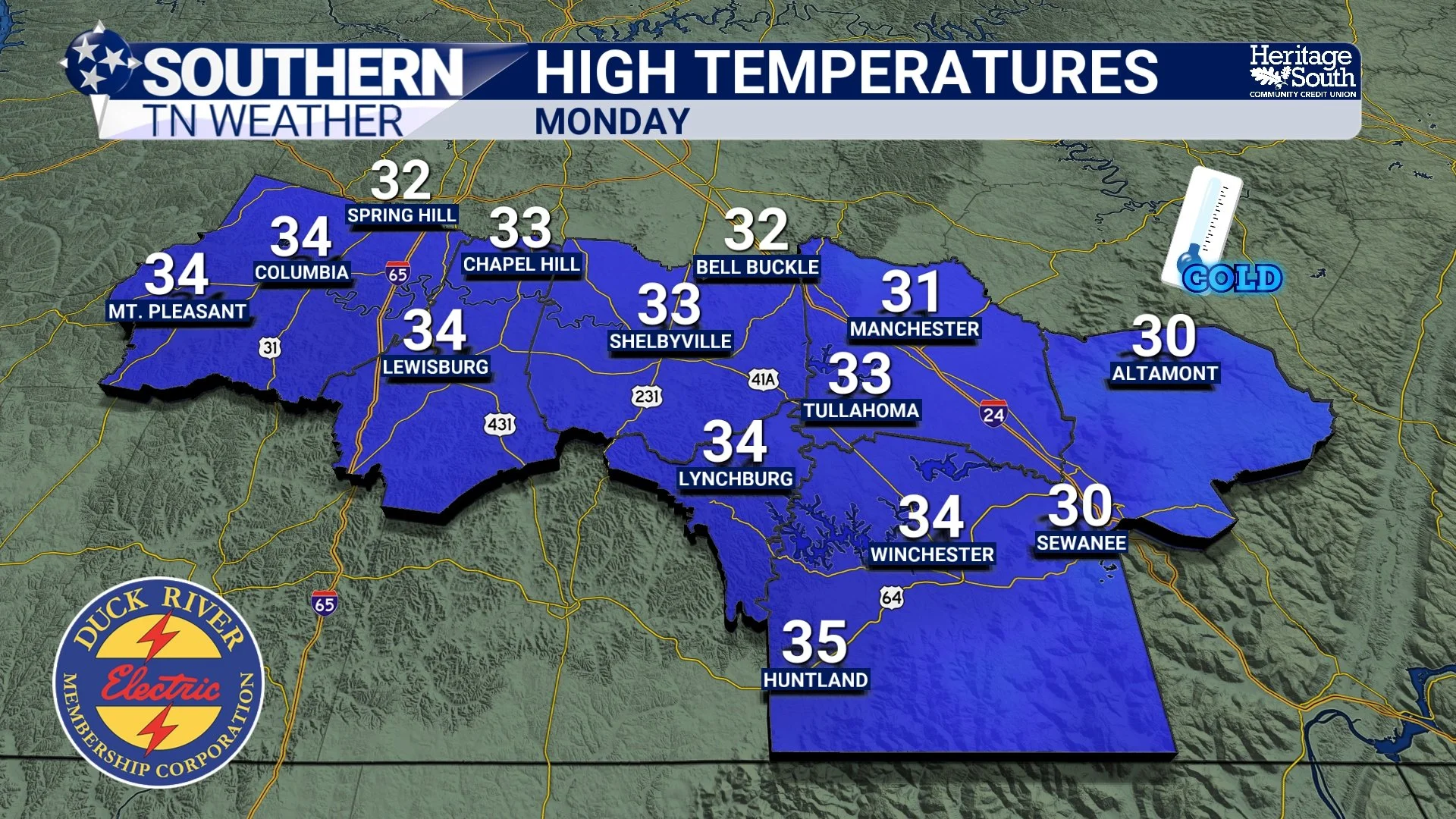
Forecast High Temps - Next Monday
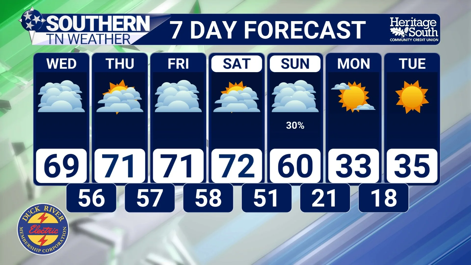
STNWX 7-Day Forecast
The Bottom Line 🧾
• Warm, cloudy conditions continue through Christmas Eve with spotty light showers
• Rainfall amounts remain minimal with little to no impact
• Christmas Day looks warm, breezy, and mostly dry
• Friday and Saturday will be the warmest days, with highs in the 70s
• A cold front arrives Sunday into Monday with widespread rain
• Temperatures drop sharply early next week, returning winter-like cold
📰 Reminder: The Southern Tennessee Weather Blog (Presented by Heritage South Community Credit Union) is updated Monday through Friday with fresh, locally tailored forecasts you can trust. PLEASE NOTE: This will be the last blog for the week due to the Christmas Holiday. Updates will still be posted on social media, the website, and the free Southern Tennessee Weather App.