
very cold weather expected monday night into tuesday
Flurries Ongoing
As of Monday afternoon, light flurries and snow showers continue to drift across Southern Middle Tennessee. The activity has been very spotty, but most locations have at least seen a few flakes flying at some point today. This trend will continue through sunset before we dry out and clear up for what will be the coldest night so far this fall. A dusting of snow (up to a half inch) will be possible across the higher elevations of Grundy County, but for the rest of us, no accumulation or impacts are expected.
A fun tidbit: several locations may break their record low maximum temperatures for November 11th. Here are the current records for today:
Columbia: 37° (1950)
Lewisburg: 39° (1941)
Shelbyville: 42° (2018)
Tullahoma: 42° (2018)
Coalmont: 42° (2008)
Lynchburg: 46° (2008)
Monteagle: 40° (1968)
Coldest air of the season settles in tonight
Once flurries move out this evening, skies will clear and winds will calm which is a perfect setup for temperatures to plummet overnight. Lows early Tuesday morning will drop into the 15 to 20 degree range across the entire area. After tonight, our growing season will officially end until next Spring.
If you haven’t already, make sure you PROTECT THE FOUR P’s:
People — especially kids at the bus stop
Pipes
Pets
Plants
Record low temperatures may also fall Tuesday morning. Here are the numbers to beat:
Columbia: 19° (1953)
Lewisburg: 17° (1913)
Shelbyville: 19° (1960)
Tullahoma: 16° (1913)
Coalmont: 21° (2018)
Lynchburg: 21° (2011)
Monteagle: 20° (1960)
With clear skies and light winds, areas of FREEZING FOG may develop by sunrise — especially near lakes, rivers, and low-lying valleys. Freezing fog forms just like regular fog, but it can create a thin glaze of ice on elevated surfaces such as bridges, overpasses, railings, and trees. This will not be a widespread travel issue, but if you encounter fog in the morning, drive carefully and watch elevated road surfaces.
Thankfully, we warm up quickly Tuesday afternoon with highs between 45 and 50 degrees.
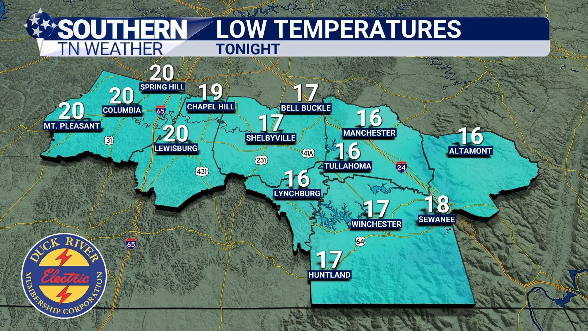
Forecast low temperatures Monday morning.
The Rest of the Week
After tonight, the rest of the work week looks absolutely fantastic. Temperatures will gradually warm each day, and by Saturday we’ll be back in the 70s, which is well above average for mid-November.
Our next chance of rain looks to arrive sometime between Sunday and next Monday, but it’s too far out for specific details. I’ll keep everyone updated throughout the week as the forecast becomes clearer.

7 Day Forecast
The Bottom Line 🧾
• Coldest night of the season arrives tonight — lows in the upper teens to around 20°
• Protect the Four P’s (people, pipes, pets, plants)
• Patchy freezing fog may form near sunrise
• A beautiful warm-up is ahead for the rest of the week
• Next rain chance returns late weekend into early next week
📰 Reminder: Our Southern Tennessee Weather Blog is updated Monday through Friday with fresh, locally tailored forecasts you can trust.
Be sure to follow along so you never miss an update!