
From Record Cold to 70s: A True Tennessee Weather Week
Record-breaking cold this morning
I think today’s blog title pretty much sums up the weather over the next few days… UP AND UP in the temperature department! If you remember yesterday’s blog, I mentioned we had a good shot at breaking records for both record low maximum temperatures on Monday and record low temperatures this morning. Well, that definitely happened — and then some.
Yesterday, every single city in our 7-county area broke its record for the coldest high temperature recorded on November 10th. And this morning, several locations broke (or tied) their record lows for November 11th:
Shelbyville: 19° — ties the record low from 1960
Winchester: 19° — new record (old: 23° in 1991)
Lynchburg: 20° — new record (old: 21° in 2011)
Coalmont: 20° — new record (old: 21° in 2018)
Keep in mind: these are preliminary numbers until the National Weather Service reviews everything. But based on the observed lows this morning (shown below), I think these records are safe to say did fall.
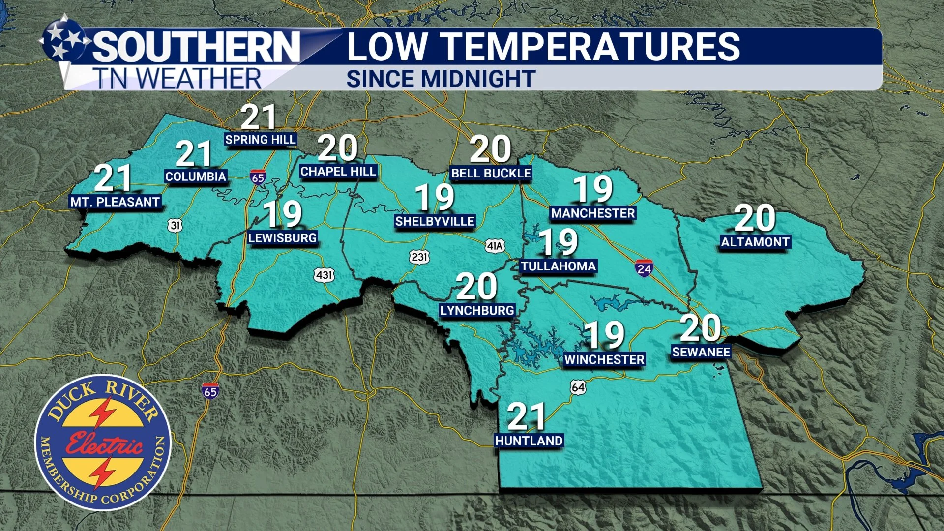
Observed low temperatures Monday morning.
The rest of the work week
The weather stays pretty quiet through the next 4–5 days. Temperatures will gradually climb, and by this weekend we’ll be sitting in the low to mid 70s — a solid 10° above average for mid-November. Normal highs this time of year are 60–62°, so yes… we’ll be quite warm heading into Friday and Saturday. Overnight lows will mostly be in the 30s and 40s, which is closer to average but still a touch above normal.
You’ll see the 7-day high temperature trend below: warm this weekend, then a dip back toward average early next week as rain chances return.
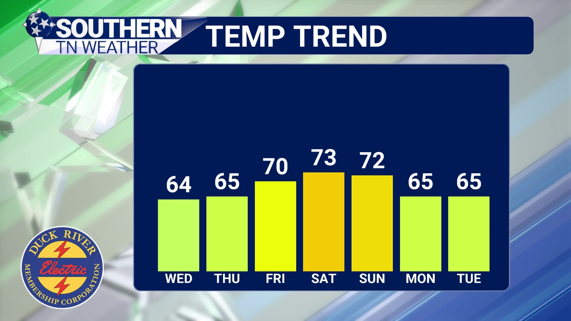
7 Day High Temperature Trend
Model Madness for next week
Here we go again with the model uncertainties… and yes, it bothers me just as much as it bothers y’all.
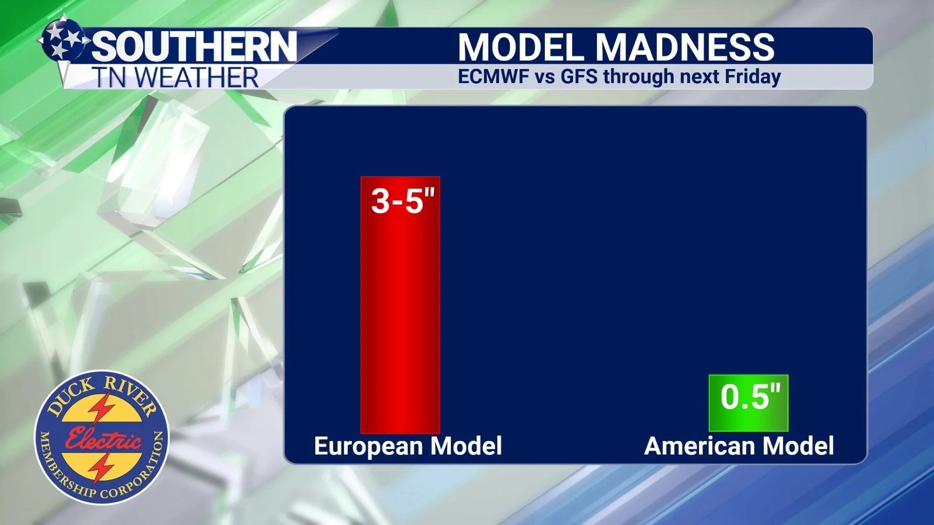
Both of our major global weather models show precipitation next week, but the differences between them are… dramatic, to say the least.
The GFS (American model) Shows a weak system Tuesday into Wednesday, followed by another round next weekend. Total rainfall through next Friday: ~0.5". On the other hand, the European model shows us getting soaked. Back-to-back-to-back rain systems from Tuesday through Friday night. Total rainfall through next Friday: 3–5".
That is a massive difference.
I get asked all the time which model I trust more — the European or the American? Personally, I lean slightly toward the European, mostly because it tends to handle convection (rain/storm dynamics) a little better. But no model is perfect. They all have strengths and weaknesses. You’ll see a graph below comparing the two solutions… it really puts the difference into perspective.
All of this is a long way of saying: we have A LOT to figure out regarding next week. Nothing is set in stone. As we get more data through the week, I’ll update everyone. Don’t go planning a full-blown washout yet — but just know the possibility is on my radar (pun fully intended).
The Bottom Line 🧾
• Temperatures are on the uptrend through this weekend
• No precipitation is expected until early next week
• Model Uncertainty for next week’s rain chances… Stay tuned for updates!
📰 Reminder: Our Southern Tennessee Weather Blog is updated Monday through Friday with fresh, locally tailored forecasts you can trust.
Be sure to follow along so you never miss an update!