
Quick Update About the Storms Friday Evening
Overview / Uncertainties
In the latest update from the Storm Prediction Center, the SLIGHT risk (level 2/5) for severe thunderstorms has been expanded, now covering nearly everyone north of the US 64 corridor in our portion of Southern Middle Tennessee. Yesterday, that risk actually shrunk — but confidence is now slowly increasing that we’ll see at least a few thunderstorms develop this afternoon and evening.
A cold front will move into the region later today from the north and west, acting as the “spark” for storm development. A broken line of storms is expected to form along this front as it arrives. Gusty south winds right now are pumping Gulf moisture into our area. While there is still uncertainty about how much moisture will ultimately be available, the latest model data has come into better agreement that we’ll have enough for at least some storm development.
As I’ve stressed all week, dewpoints near 60° are the “sweet spot” for cool-season severe weather. Below that, the threat becomes far more questionable. Many locations are already sitting close to that 60° mark early this afternoon. THIS DOES NOT guarantee stronger storms — but it does increase confidence that the moisture piece may be there when the front arrives. There is plenty of wind energy aloft; moisture is the deciding factor.
This is NOT a setup where every storm within the line will be severe. Instead, expect scattered warnings and pockets of stronger wind gusts, not a widespread severe event.
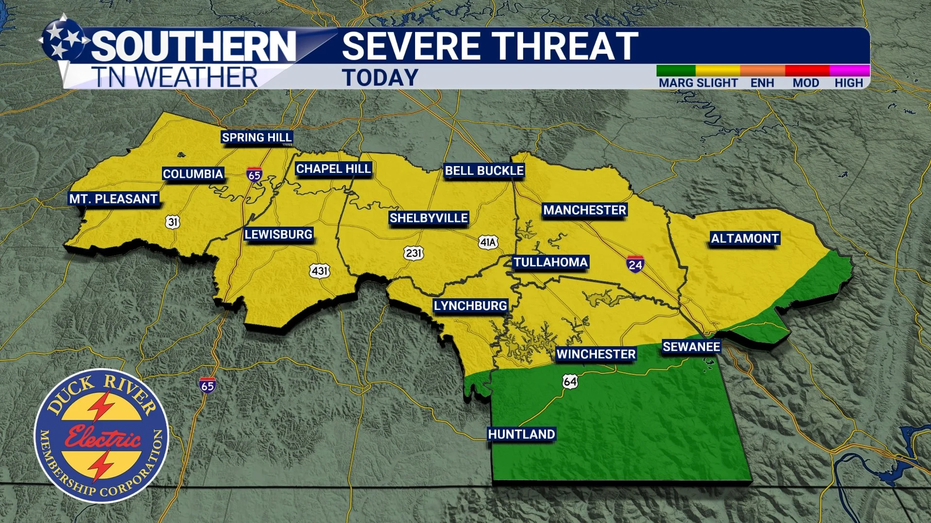
SPC risk this afternoon and evening
Threats
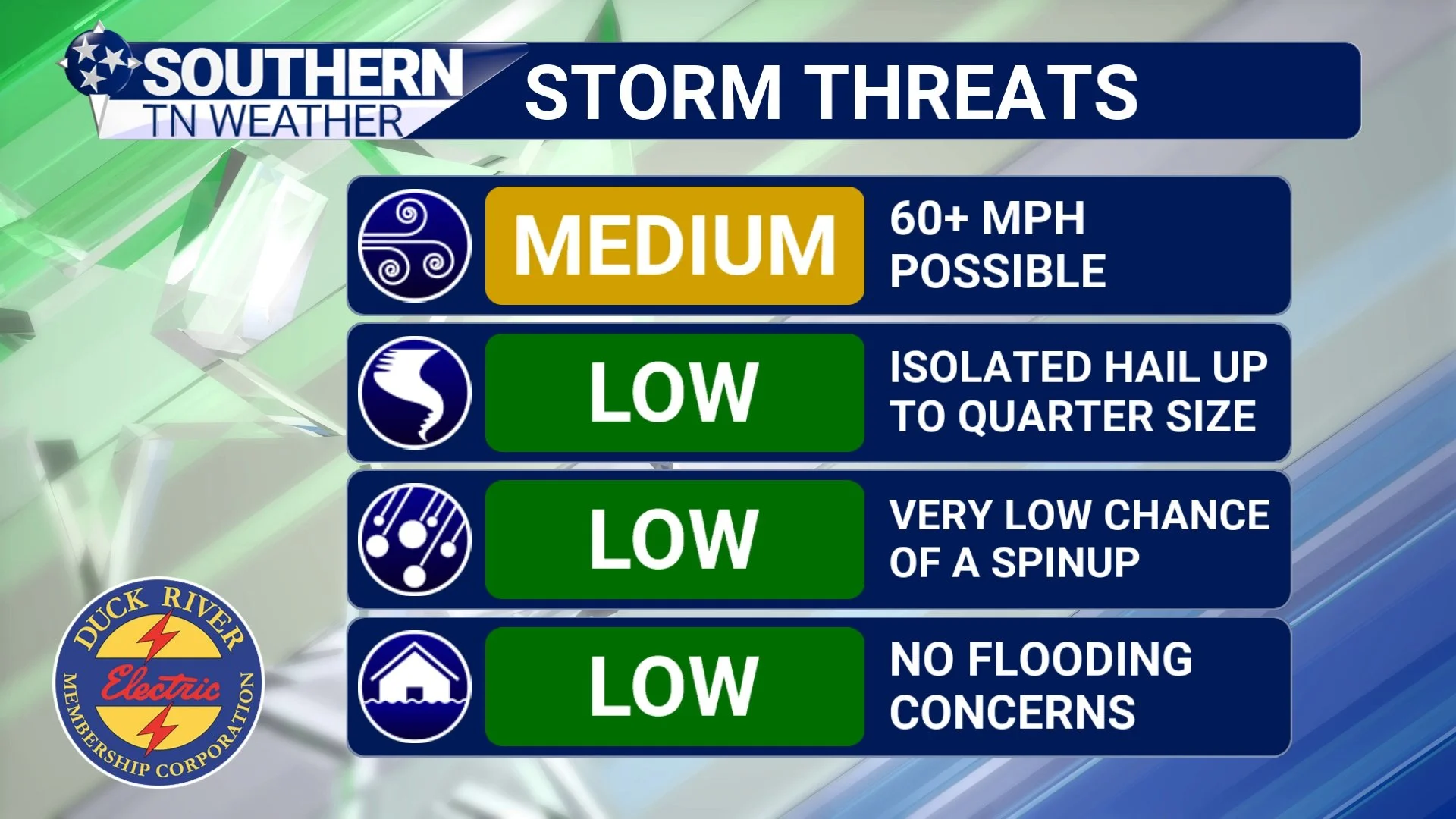
Here’s what you need to know about the hazards today, assuming storms are able to become strong:
Damaging Winds (MAIN THREAT) - A medium risk exists for straight-line wind gusts over 60 MPH, which is the threshold where widespread minor damage becomes more likely.
Tornadoes (LOW THREAT) - Some have asked if the tornado threat has increased. In my opinion: No. A brief spin-up tornado cannot be ruled out, but this is not the dominant threat.
Hail (LOW THREAT) - Quarter-size hail is possible in the strongest storms, but not expected to be a major issue.
Flooding (NEARLY ZERO) - Storms will be moving too quickly for any flooding concerns.
Threats this evening
UPDATED TIMING
Before diving into the exact timing windows, please remember that this graphic shows estimated arrival times, NOT how long the storms will last.
The latest expected timeline as of early this afternoon:
I-65 corridor: 5 PM – 7 PM
Bedford, Moore, Coffee: 7 PM – 9 PM
Franklin, Grundy, Plateau: 9 PM – 11 PM
These storms will be fast-moving, so rainfall likely lasts 30 minutes to an hour at most. Of course, these times may shift slightly as storms develop to our west and we monitor real-time radar trends.

Times of arrival
Housekeeping notes
Since this is my first severe weather event as Southern Tennessee Weather, I want everyone to know how I operate during events like this:
Live Coverage: I will provide continuous live coverage on Facebook, YouTube, and X whenever a Severe Thunderstorm Warning or Tornado Warning is issued for any area I serve.
Frequent Updates: Expect radar and storm updates across social media as needed throughout the event.
Always-Available Resources: Live radar, futurecasts, and the 24/7 weather channel stream are available right here on the website. - Click the “WATCH LIVE” header at the top of the website to watch the stream.
Mobile App Alerts: The Southern Tennessee Weather App sends instant push alerts when warnings are issued for your specific location.
I’m here for you — ALWAYS. Day or night, I’ll be here to keep you informed and safe.
The Bottom Line 🧾
• A broken line of showers and storms is expected to traverse the region this evening.
• A few storms could be strong to severe with damaging winds being the primary concern.
• This is not a major severe weather outbreak by any stretch of the imagination, but we need to pay attention this evening!
📰 Reminder: Our Southern Tennessee Weather Blog is updated Monday through Friday with fresh, locally tailored forecasts you can trust.
Be sure to follow along so you never miss an update!