
Very Cold Air Arrives Tonight as Winter Storm Signals Grow

The Southern Tennessee Weather Blog is proudly presented by Heritage South Community Credit Union.
We Help When Others Won’t!
Visit https://www.heritagesouth.org/ today to see how HSCCU can help YOU!
Southern Middle Tennessee is settling into its coldest stretch of the winter so far, and the atmospheric pattern responsible is only becoming more firmly established. While the short-term forecast focuses on reinforcing cold air and generally quiet conditions over the next couple of days, attention is increasingly shifting toward a potential winter weather system late this week into the weekend. Confidence is growing that the large-scale setup will support winter weather somewhere across the southern United States from Friday through Sunday. What remains uncertain (and what we’ll be refining throughout the week) is how that system ultimately impacts Southern Middle Tennessee.
This is not yet about snowfall totals. Those conversations will come later as confidence increases. Right now, the focus is on the pattern.
Today and Tonight: The Coldest Night of the Year So Far
Southern Middle Tennessee remains under the influence of a reinforcing Arctic air mass today. Temperatures have struggled through the 30s, and a secondary cold front is moving through the region this afternoon. That front is increasing northwest winds and ushering in another surge of cold air. Clouds will gradually clear this evening as surface high pressure builds directly overhead. With clearing skies and winds becoming light, ideal radiational cooling conditions will develop overnight. This will lead to the coldest night of 2026 so far.
Overnight lows are expected to fall into the teens across much of the area, with single digits possible in the usual cold pockets. Winds will be light, so wind chills will be close to actual air temperatures — but this will still be dangerously cold for anyone outdoors without proper protection.
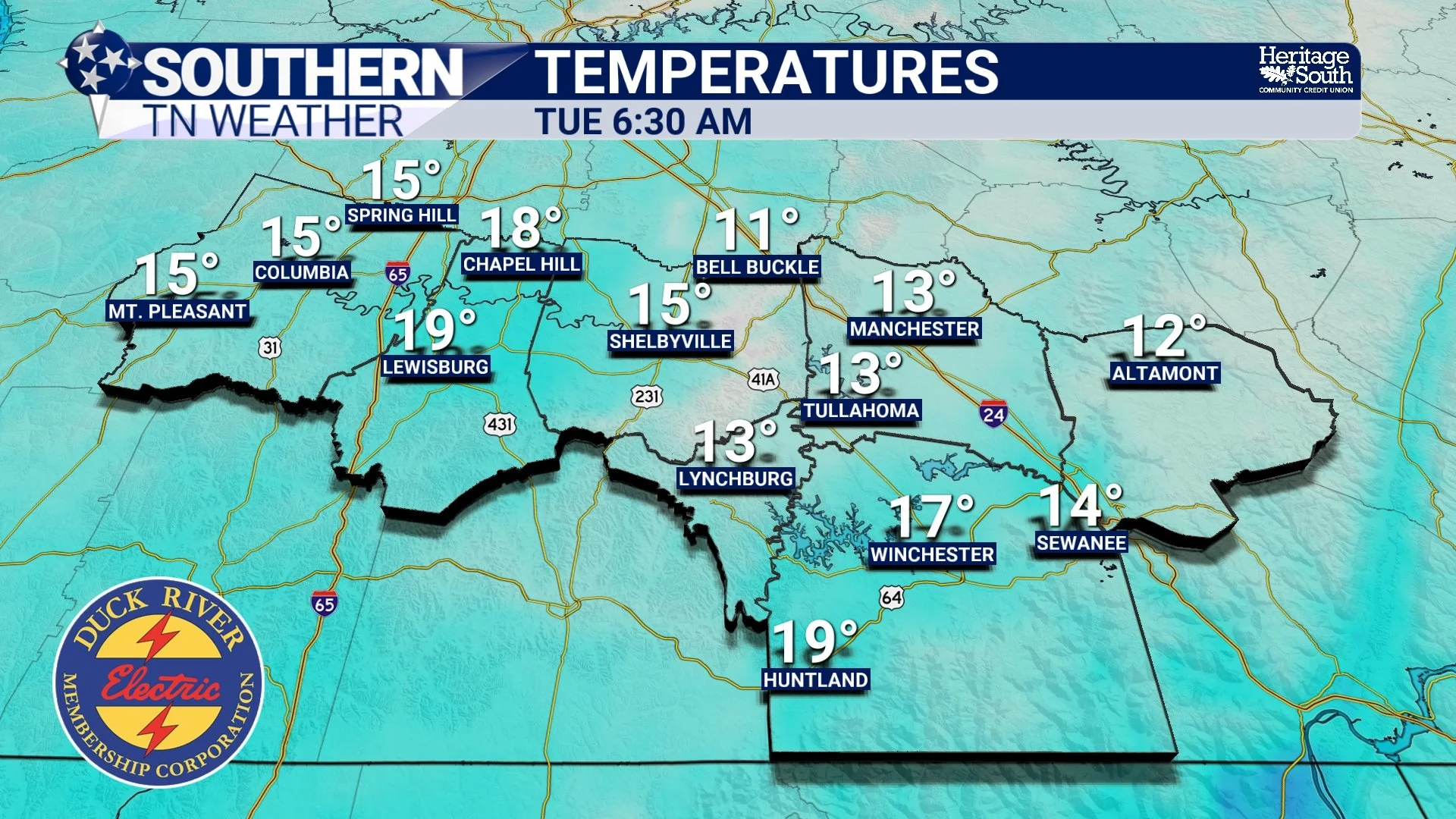
Low Temps - Tonight
Tuesday and Wednesday: A Brief Moderation, Then Clouds Return
Tuesday will be quiet but cold. Sunshine and a developing light southerly breeze will allow temperatures to recover above freezing, with highs generally in the upper 30s to lower 40s. Wednesday will start cold, but about 10 degrees milder than Tuesday morning. As surface high pressure shifts east, south winds will increase and clouds will thicken. A weak clipper system will approach from the northwest, bringing medium chances for light rain showers Wednesday afternoon into Wednesday evening.
At this time, precipitation Wednesday appears most likely to fall as rain. A brief rain-to-snow mix on the Plateau Wednesday night cannot be ruled out, but no accumulation is expected with that system.
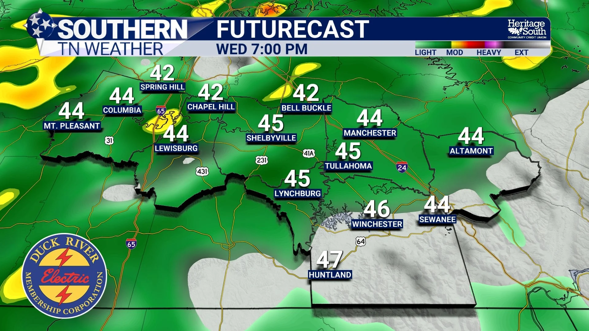
Futurecast - Wednesday Evening
The Bigger Story: A Winter Storm Signal Is Strengthening
Beyond midweek, the large-scale pattern becomes the dominant story. Broad upper-level troughing will be anchored across the eastern half of the United States. Arctic air will not retreat — it will continue to spill southward. At the same time, guidance increasingly supports a southern-stream system emerging from the Southwest and interacting with Gulf moisture. This is a classic winter weather setup for the southern tier of the country.
The Weather Prediction Center is now highlighting increasing confidence in a developing winter storm across the southern Plains, Lower Mississippi Valley, Southeast, and Mid-Atlantic Friday into the weekend. That places Southern Middle Tennessee squarely in a region that will need to be monitored closely for winter impacts.
New Data: Probabilities Are Beginning to Speak
As of the latest National Blend of Models update, measurable winter weather probabilities are now appearing locally. Current guidance indicates:
• A 20–30% chance of at least 3 inches of snow
• A 10–20% chance of at least 0.25 inches of ice
These numbers are not a forecast. They will change. Some will rise. Some may fall.
But the important signal is this: ensemble and NBM probabilities are trending upward. That tells us confidence is increasing that some form of impactful winter weather is possible between Friday and Sunday. What remains uncertain (and what will determine the outcome) includes storm track, timing, cold air depth, precipitation type, and where the northern edge of heavier moisture ultimately sets up.
Right now, there are still solutions that favor mostly snow, others that lean toward ice, and some that keep the heaviest precipitation south and east of our area. That spread is completely normal at this range.
The signal is strengthening. The details are not locked in. Latest Weather Prediction Center outlooks place our region in the transition zone between snow and freezing rain — the “battle zone.” And locally, we’ve dealt with setups like this plenty of times before… Either outcome causes issues, but freezing rain is the scenario we especially do not want to see.
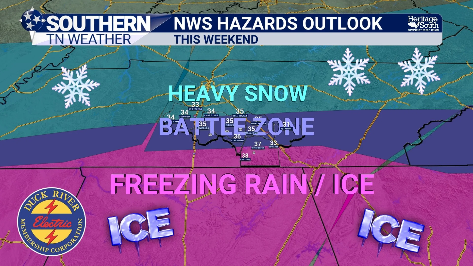
Overall Setup - This Weekend
Cold Will Be an Impact Regardless
One element that is becoming increasingly clear is the cold. Even outside of any winter precipitation, Arctic air will be entrenched across the region this weekend.
Latest guidance supports:
• Overnight lows in the teens for many locations
• Single-digit lows possible Saturday night and Sunday night
If winter precipitation does occur, these temperatures would strongly favor road impacts, refreezing issues, and prolonged slick conditions.
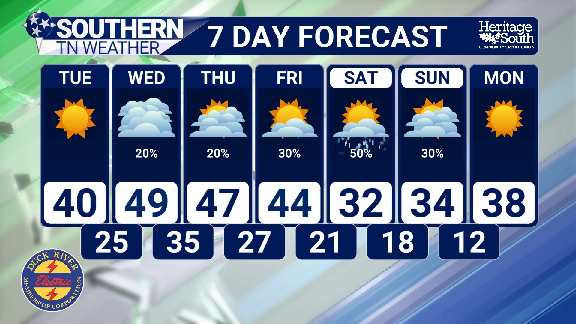
STNWX 7-Day Forecast
The Bottom Line 🧾
• Coldest night of the winter so far arrives tonight
• Light rain chances return Wednesday with little expected impact
• A strengthening winter storm signal is emerging for late week into the weekend
• Latest probabilities show increasing potential for both snow and ice
• Exact timing, type, and amounts remain uncertain
• Very cold temperatures will be impactful regardless of precipitation
This is the type of setup that requires daily refinement. The ingredients are coming together — how they ultimately align is what the next few days will determine!
📰 Reminder: The Southern Tennessee Weather Blog (Presented by Heritage South Community Credit Union) is updated Monday through Friday with fresh, locally tailored forecasts you can trust