
A BUSY FEW DAYS ON TAP!
The rest of Today
It’s been a downright beautiful Thursday across Southern Middle Tennessee, and this pleasant weather should hold through the rest of the afternoon and evening. But don’t get too comfortable — a BIG flip in our weather pattern is on the way over the next 48 to 72 hours. Two cold fronts are set to move through, dropping us straight into our first deep freeze of the season. But before we talk about that cold air, we need to address the chance for showers and storms on Friday… and maybe even a few lingering into Saturday.
Overview - Friday
Clouds will start thickening early Friday morning as moisture is drawn in from the south. A few light, scattered showers are possible through the morning and early afternoon, but this early activity should behave. Winds out of the south may gust up to 20 MPH ahead of Cold Front #1, which will sweep through late Friday night. With wind energy aloft, a passing cold front, and at least some modest moisture return, showers and thunderstorms are expected to develop along the front Friday afternoon and evening. That’s why the Storm Prediction Center continues to place our region under a MARGINAL (1/5) to SLIGHT (2/5) risk for severe thunderstorms.
However — and this is something I’ve emphasized all week — the overall severe weather threat remains LOW. Moisture return has been the biggest question mark, and the SLIGHT risk area has been shrinking over time, matching what the models have been suggesting. Still, if we do hit that lower-end moisture benchmark (dewpoints near 60°), a few strong to severe storms could form.
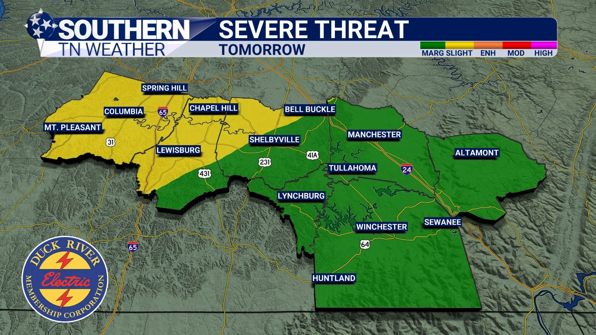
Friday’s SPC risk
Uncertainty and Timing - Friday
There is still notable uncertainty in how tomorrow’s setup will evolve. Some of our newest short-range model data is surprisingly dry and quiet for tomorrow evening, aside from a few isolated showers. As always during cool-season events, moisture will be the deciding factor in whether storms can even develop. This is one of those classic “wait and see” setups where we’ll need to rely on actual observed data tomorrow (dewpoints, surface moisture, instability, and live radar trends) because models continue to bounce between different scenarios.
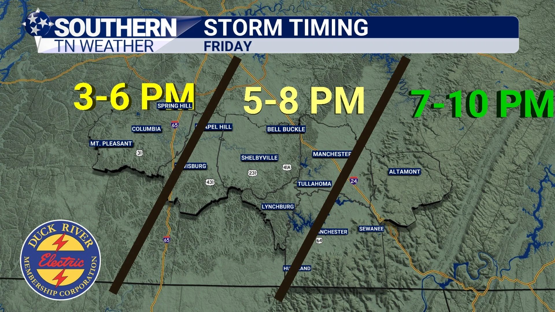
For now, here is the expected timing for precipitation on Friday (whether that ends up being showers or storms):
West of I-65: 3 PM – 6 PM
Central counties (Bedford, Moore, Coffee): 5 PM – 8 PM
Cumberland Plateau: 7 PM – 10 PM
Storm intensity should weaken as the evening goes on, especially toward the Plateau where instability drops quickly after sunset.
The “futurecast” image below shows one potential scenario for 7 PM Friday. My in-house model may be a bit bullish, but it’s still within the realm of possibility.
Timing - SUBJECT TO CHANGE
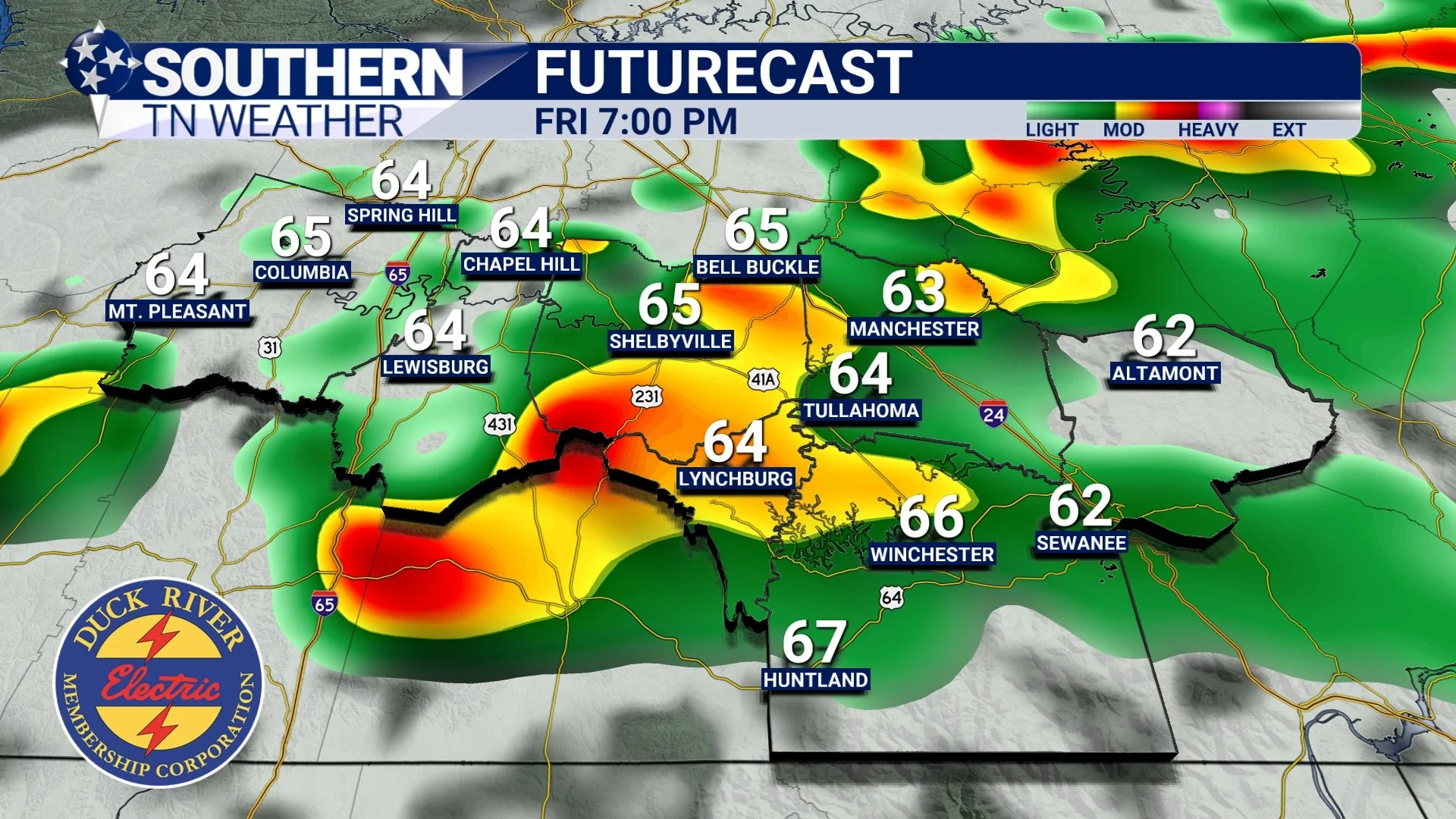
STNWX futurecast radar - tomorrow at 7:00 PM
Storm Threats - Friday
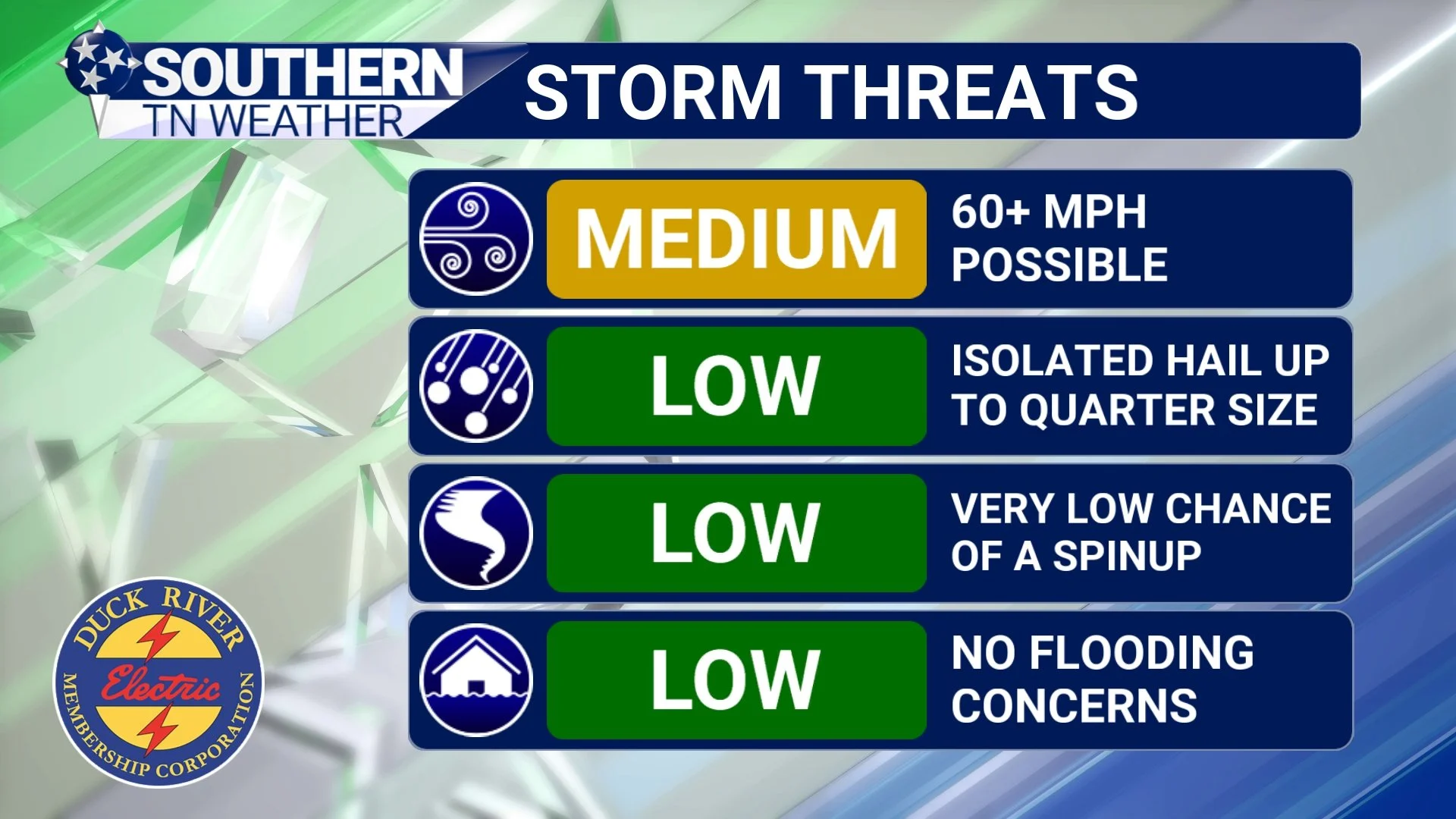
Even though the severe weather threat is low, here’s a clear breakdown of what could happen if storms form:
Damaging Winds (Main Threat):
A medium risk exists for damaging wind gusts over 60 MPH, which is the threshold where widespread minor damage becomes more likely.Tornadoes:
The tornado risk is low, but not zero. A brief spin-up tornado can’t be ruled out given the wind energy overhead.Hail:
Quarter-size hail is possible in any stronger storms, but this is not expected to be a major factor.Flooding:
Storms will be moving too fast for any flooding concerns. I almost didn’t include this one — the threat is that low.
Storm threats
Saturday and beyond
As mentioned earlier, we’re on the verge of a major weather rollercoaster. The first cold front arrives Friday night, followed by a reinforcing cold front Saturday evening. That second front may squeeze out a few spotty showers, but the chance sits around 20% and rainfall looks minimal. Most of Saturday will actually be pleasant, aside from some cloud cover.
We’ll watch for a few more light, brief showers Saturday night into Sunday as cold front #2 pushes in. If you saw my social media post earlier, you might’ve noticed the SPC briefly outlined a severe risk for Saturday — they’ve since removed it, which was the right call. I never saw anything particularly concerning for Saturday’s setup.
Deep Freeze Incoming - And Maybe a Few Snowflakes?
Now for the big story: the coldest air of the season. Highs on Monday will struggle to hit 40 degrees, and lows on both Monday and Tuesday morning will drop into the low to mid 20s. Some rural communities may even briefly dip into the upper teens. A few light snow flurries or snow showers cannot be ruled out Monday morning, especially with the reinforcing cold air overhead. However, no accumulations or impacts are anticipated and chances are only between 10 and 20 percent right now. The better chance for flakes remains across the Northern Cumberland Plateau and the Smokies. At the end of the day, the cold (not the snow) is the headline.
Prepare yourself… we’re about to go from the 70s to the 20s in just a few days!
The Bottom Line 🧾
• Showers and storms possible Friday with cold front number one, a few of which could be strong to severe but uncertainty remains high.
• A few isolated showers will be possible Saturday night with cold front number two.
• First hard freeze of the season Monday and Tuesday. A few flurries and light snow showers will be possible early Monday morning.
📰 Reminder: Our Southern Tennessee Weather Blog is updated Monday through Friday with fresh, locally tailored forecasts you can trust.
Be sure to follow along so you never miss an update!