

The Southern Tennessee Weather Blog is proudly presented by Heritage South Community Credit Union.
We Help When Others Won’t!
Visit https://www.heritagesouth.org/ today to see how HSCCU can help YOU!
With winter quickly approaching, it won't be too much longer before we're having conversations about the possibility of winter weather across Southern Middle Tennessee. If you've lived here for any length of time, you know that forecasting winter weather in this part of the country can be quite challenging! Sometimes, the difference between a beautiful blanket of snow, a dangerous ice storm, and nothing more than a cold, miserable rain comes down to just a couple of degrees in the atmosphere.
One of the biggest misconceptions about winter weather is that the temperature outside your home determines what type of precipitation you'll receive. While the surface temperature is certainly an important piece of the puzzle, meteorologists must evaluate temperatures throughout several thousand feet of the atmosphere to determine what will ultimately reach the ground. In fact, it can be snowing thousands of feet above your backyard while you're experiencing nothing more than a cold rain at the surface!
With that in mind, let's take a closer look at the four primary precipitation types we deal with during the winter months, how they form, and why forecasting them can be particularly difficult here in Southern Middle Tennessee.
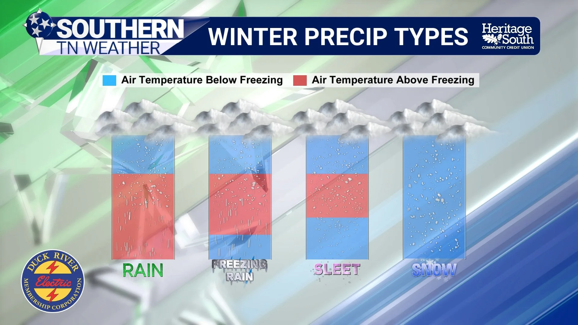
It Often Starts as Snow!
Believe it or not, much of the precipitation associated with our winter storm systems initially develops as ice crystals high up in the atmosphere, even when temperatures at the surface are well above freezing. One particularly important region of the atmosphere that meteorologists evaluate when forecasting winter weather is known as the dendritic growth zone (DGZ). This is generally the portion of a cloud where temperatures range between approximately -12°C and -18°C (0°F to 10°F), conditions favorable for the growth of those classic, branching snow crystals when sufficient moisture is present.
As these ice crystals grow, collide, and stick together, they can eventually become large enough to fall toward the Earth's surface as snowflakes. However, their journey through the atmosphere is far from over. Depending on the temperatures and moisture content of the atmospheric layers they encounter on their way down, those snowflakes could undergo several transformations before ever reaching your backyard.
Meteorologists refer to the distribution of temperatures at different heights as the vertical temperature profile. We evaluate this profile using atmospheric soundings, which can be obtained from weather balloons or generated using computer forecast models. These soundings allow us to identify layers of above-freezing and below-freezing temperatures throughout the atmosphere. Understanding the depth and temperature of these layers is critical when determining which precipitation type is most likely to occur.
The Four Primary Winter Precipitation Types
SNOW
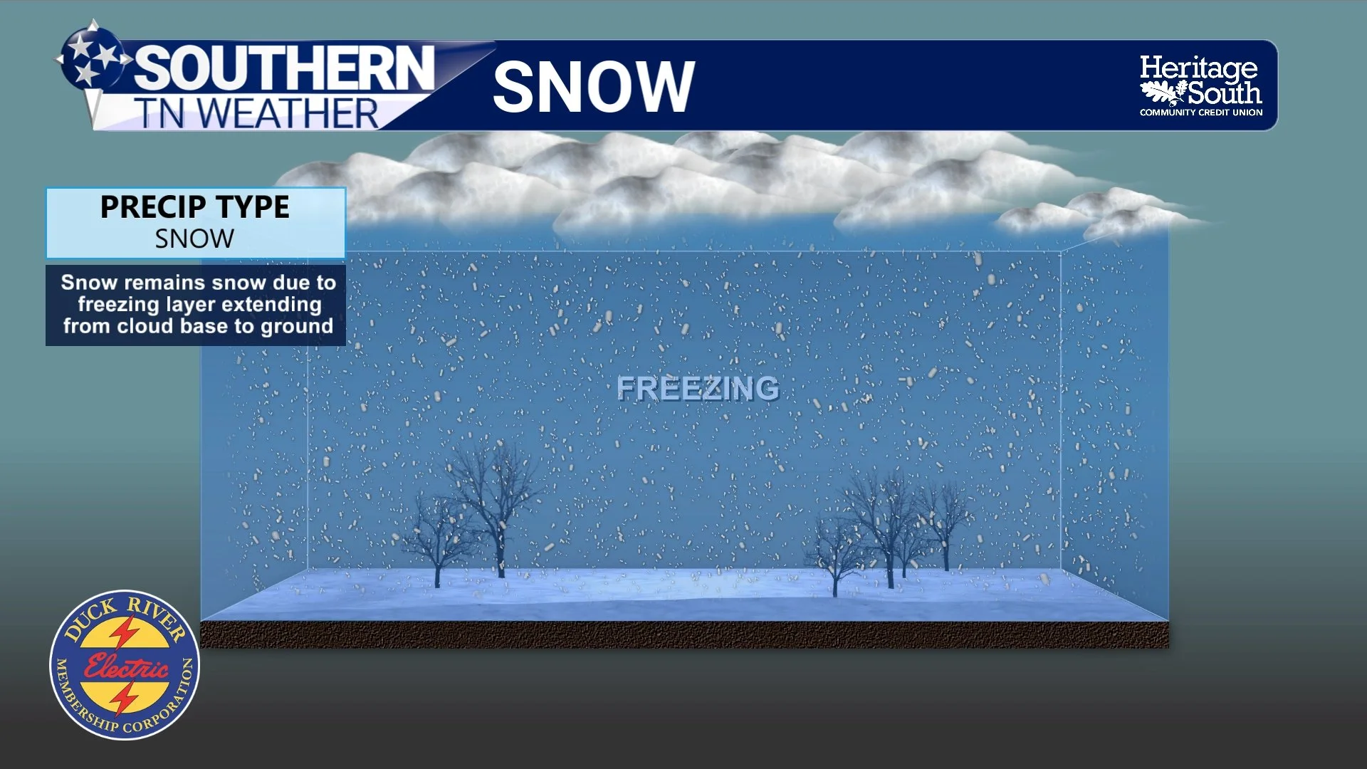
Snow is generally the most straightforward precipitation type to understand. When snowflakes fall through an atmospheric column that remains sufficiently cold, they reach the ground without completely melting. This typically occurs when temperatures remain at or below freezing throughout most of the atmosphere.
However, you may have noticed that it doesn't necessarily have to be 32 degrees or colder outside for it to snow. Snowflakes can survive their journey through a shallow layer of above-freezing air near the surface, particularly when temperatures are only marginally above freezing or precipitation is falling heavily. It's entirely possible to see snow falling with surface temperatures in the middle or even upper 30s under the right atmospheric conditions.
Whether that snow actually accumulates is an entirely different conversation. Ground temperatures, snowfall rates, solar radiation, and the temperature of the surrounding air all influence how efficiently snow accumulates. This is why we sometimes see snow accumulating on grassy surfaces, rooftops, and vehicles while nearby roadways remain nothing more than wet.
SLEET
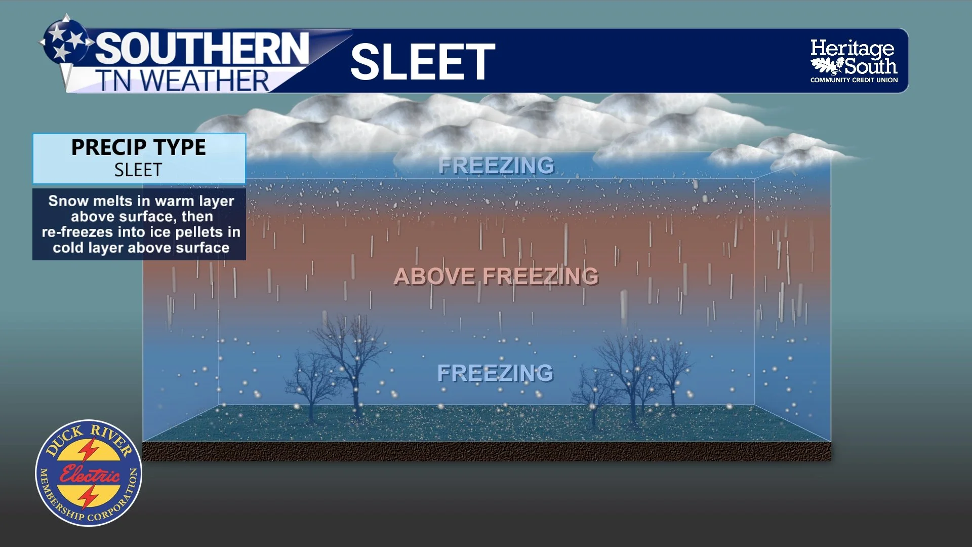
Sleet, technically referred to as ice pellets, forms when snowflakes encounter a layer of above-freezing air somewhere above the Earth's surface. This layer is often referred to as a warm nose because of how it appears on an atmospheric sounding. As snowflakes fall through this warmer air, they partially or completely melt.
Below that warm layer, however, lies another sufficiently deep and cold layer of below-freezing air. As the partially melted snowflakes or liquid droplets fall through this colder layer, they refreeze into small pellets of ice before reaching the surface. Unlike snowflakes, these ice pellets are relatively dense and often bounce when they strike the ground. You can usually hear sleet hitting your windows or rooftop, making it one of the easier winter precipitation types to identify.
While sleet generally doesn't accumulate on trees and power lines as efficiently as freezing rain, it can still create extremely hazardous travel conditions. Significant sleet accumulations can cover roadways in a dense layer of ice pellets that may be difficult to remove and slow to melt.
FREEZING RAIN
Freezing rain is arguably one of the most dangerous precipitation types we experience here in Southern Middle Tennessee. Its formation is somewhat similar to that of sleet, but there's one VERY important difference in the vertical temperature profile.
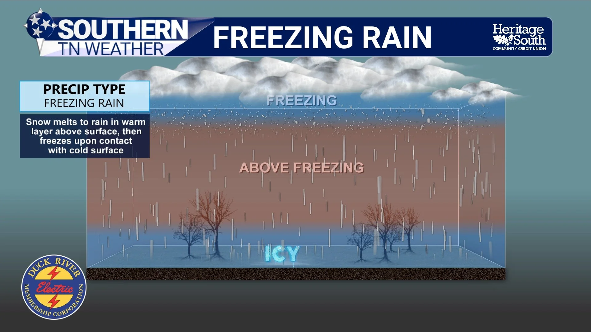
Snowflakes initially fall through a sufficiently warm layer of the atmosphere, causing them to melt completely into liquid raindrops. However, the layer of below-freezing air near the Earth's surface is too shallow or not cold enough for those raindrops to refreeze into ice pellets before reaching the ground. Instead, they become supercooled liquid droplets, meaning they remain liquid despite having a temperature below freezing.
When these supercooled droplets strike a sufficiently cold surface, such as a roadway, tree branch, power line, or vehicle, they freeze and gradually produce a coating of ice commonly referred to as glaze ice.
Even relatively small amounts of freezing rain can create significant travel problems, particularly on bridges and overpasses. As ice accumulations increase, the additional weight placed on trees and power lines can lead to broken branches, downed trees, and widespread power outages. The severity of these impacts also depends heavily on wind speeds, the duration of the event, and how efficiently ice accumulates on exposed surfaces.
Unlike snow or sleet, freezing rain can be particularly deceptive because it often looks just like ordinary rain as it's falling. Unless you're paying close attention to surface temperatures and ice accumulations, you might not immediately realize that dangerous conditions are developing outside.
RAIN
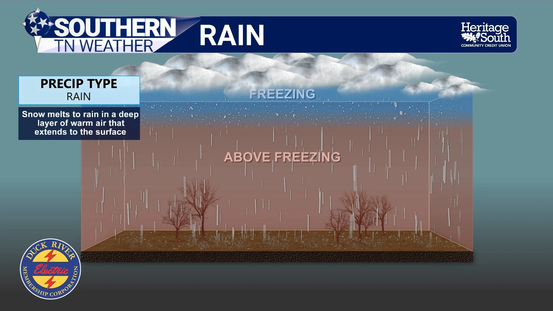
Finally, we have plain old rain. When snowflakes fall through a sufficiently deep layer of above-freezing air, they completely melt into liquid droplets. If those droplets encounter no sufficiently cold layer near the surface to refreeze or become supercooled, they simply reach the ground as rain.
Of course, not all rain necessarily begins as snow. Liquid precipitation can also develop through processes entirely within liquid-water clouds. However, many of our larger winter storm systems feature precipitation that initially develops as ice crystals before melting on the way down.
Here in Southern Middle Tennessee, we frequently find ourselves dealing with temperatures in the middle and upper 30s during winter storm systems. While those temperatures may seem frustratingly close to supporting winter weather, even a relatively small amount of additional warmth throughout the atmospheric column can be enough to turn a potentially significant snow event into nothing more than a cold rain.
Why Winter Weather Is So Difficult to Forecast in Southern Middle Tennessee
Our geographical location makes winter weather forecasting particularly challenging. We're frequently situated near the dividing line between cold Arctic air to our north and relatively warm, moisture-rich air originating from the Gulf to our south. While cold air may be firmly entrenched near the Earth's surface, warmer air can simultaneously be transported northward several thousand feet above our heads.
This process is known as overrunning, and it's a common setup associated with winter weather events across the southeastern United States. Because the colder air is denser, it can remain trapped near the surface while warmer air moves over the top of it. From a forecasting standpoint, this is where things can get particularly complicated.
Imagine that the temperature outside your home is 28 degrees while precipitation is falling. You might naturally assume that you're going to receive snow because temperatures are below freezing. However, if temperatures several thousand feet above your home are in the upper 30s or lower 40s, that snow could completely melt before entering the shallow layer of colder air near the surface. Instead of snow, you could end up experiencing a significant freezing rain event.
A change of just a degree or two within that elevated warm layer could determine whether snowflakes partially melt, completely melt, or survive their journey through the atmosphere. Similarly, relatively small changes in the depth and temperature of the colder air near the surface can determine whether liquid droplets refreeze into sleet or remain supercooled and produce freezing rain.
This is why meteorologists spend so much time examining atmospheric soundings during the days leading up to a potential winter weather event. We're not simply looking at a map of surface temperatures or snowfall accumulations. We're evaluating the entire atmospheric column, the availability of moisture, the strength of warm-air advection, precipitation rates, and how all of these factors may evolve throughout an event.
Our local terrain adds yet another layer of complexity. The higher elevations of the Cumberland Plateau, rolling hills of the Highland Rim, and sheltered valleys throughout Southern Middle Tennessee can all experience slightly different temperature profiles. It's entirely possible for one community to experience snow while another community just a few miles away receives sleet or freezing rain.
Don't Forget About the Wet-Bulb Temperature!
Another important consideration when forecasting winter precipitation is something known as the wet-bulb temperature. Simply put, the wet-bulb temperature represents how cool the air can become through evaporation under a given set of atmospheric conditions.
When precipitation begins falling into a relatively dry layer of air, some of that precipitation evaporates or sublimates before reaching the ground. These processes require energy, which is drawn from the surrounding environment, causing the air to cool. This cooling can sometimes be substantial enough to change the precipitation type that ultimately reaches the surface.
For example, temperatures might initially be around 37 degrees ahead of an approaching winter storm, but relatively dry air could support a wet-bulb temperature near 31 degrees. As precipitation begins falling and the atmosphere gradually becomes saturated, temperatures may drop toward that wet-bulb temperature, potentially allowing winter precipitation to reach the ground. Melting snowflakes also absorb heat from the surrounding air, providing another mechanism for atmospheric cooling. During certain weather patterns, these processes can help transition an initially cold rain into a mixture of rain and snow or even all snow.
Of course, these cooling processes must be evaluated alongside other factors, such as ongoing warm-air advection. Just because the wet-bulb temperature is below freezing doesn't automatically guarantee winter weather, but it's certainly an important piece of the forecasting puzzle.
The Bottom Line 🧾
Snow: Snowflakes reach the ground without completely melting.
Sleet: Snowflakes partially or completely melt before refreezing into ice pellets.
Freezing rain: Snowflakes completely melt, becoming supercooled liquid droplets that freeze upon contact with sufficiently cold surfaces.
Rain: Snowflakes completely melt and reach the ground as ordinary liquid precipitation.
Surface temperatures alone cannot determine which precipitation type will occur.
Relatively small temperature changes throughout the atmosphere can have significant implications for winter weather forecasts.
📰 Reminder: The Southern Tennessee Weather Blog, presented by Heritage South Community Credit Union, is updated Monday through Friday with fresh, locally tailored forecasts you can trust
