

The Southern Tennessee Weather Blog is proudly presented by Heritage South Community Credit Union.
We Help When Others Won’t!
Visit https://www.heritagesouth.org/ today to see how HSCCU can help YOU!
It's that time of year when you practically need two different outfits to get through the day across Southern Middle Tennessee! You might find yourself scraping frost off your windshield and blasting the heater on your way to work in the morning, only to be rolling down the windows and enjoying temperatures in the 60s by the time you head home. That's exactly the kind of weather pattern we're looking at this week, with some communities experiencing temperature swings of 30–40 degrees within a single day!
While large temperature swings aren't particularly unusual during the fall months, there's actually quite a bit of interesting meteorology behind them. You might assume that if temperatures start out significantly colder in the morning, they're destined to remain colder throughout the afternoon. However, under the right atmospheric conditions, temperatures can recover rather dramatically within just a few hours of sunrise.
So, what makes these large temperature swings possible, why are they more noticeable during certain weather patterns, and why might your backyard experience a considerably larger temperature swing than someone living just a few miles away? Let's dive into the science behind it!
Understanding the Diurnal Temperature Range
In meteorology, we refer to the difference between the highest and lowest temperatures recorded within a day as the diurnal temperature range, often abbreviated as DTR. For example, if the temperature drops to 27 degrees in Shelbyville early in the morning before climbing to 61 degrees during the afternoon, our diurnal temperature range would be 34 degrees. While that might seem like a rather impressive temperature swing, it's actually fairly common during periods of clear skies, light winds, and relatively dry air.
The temperature of the atmosphere near the ground is largely influenced by the exchange of energy between the Earth's surface and the surrounding atmosphere. During the daytime, incoming solar radiation warms the ground, which then transfers heat into the air immediately above it. As the day progresses, atmospheric mixing helps distribute that warmth vertically through the lower atmosphere. Interestingly enough, our warmest temperatures typically occur several hours AFTER solar noon because the Earth's surface continues receiving more energy than it's losing for a portion of the afternoon.
Once the sun goes down, however, that energy balance changes. Without incoming solar radiation, the Earth's surface continues emitting infrared radiation, gradually losing heat throughout the night. The air immediately above the ground cools as well, which is why our lowest temperatures typically occur near or shortly after sunrise. The magnitude of that overnight cooling, combined with how efficiently the surface warms during the following day, ultimately determines how large our daily temperature range becomes.
During a weather pattern like the one we're currently experiencing, both processes can be particularly efficient. We're losing substantial amounts of heat overnight while gaining enough energy during the day to support a rather impressive temperature recovery. The result is a morning that feels like winter and an afternoon that feels more like early fall!

Why Dry Air, Clear Skies, and Light Winds Make Such a Difference
One of the most important ingredients in producing large daily temperature swings is the amount of moisture in the atmosphere. Water vapor is a naturally occurring greenhouse gas that absorbs and emits infrared radiation. When the atmosphere contains relatively little moisture, less infrared radiation is generally emitted back toward the Earth's surface, allowing for more efficient nighttime cooling. Conversely, a more humid atmosphere can help reduce the rate at which the surface loses heat overnight.
Cloud cover also plays a HUGE role. During the daytime, clouds reflect a portion of the incoming solar radiation back into space, reducing the amount of energy available to warm the Earth's surface. At night, however, clouds absorb and emit infrared radiation, including some directed back toward the ground. This reduces net radiational heat loss and generally keeps overnight temperatures warmer than they would otherwise be under clear skies.
Think about a rainy, overcast November day compared to the weather we're experiencing this week. On a cloudy day, we might start the morning at 48 degrees and only warm to 55 degrees during the afternoon, producing a diurnal temperature range of just seven degrees. Under clear skies and dry conditions, we might start at 27 degrees and warm to 65 degrees, producing a temperature range of 38 degrees! Even though the second morning started considerably colder, the afternoon ended up being much warmer thanks to more efficient solar heating.
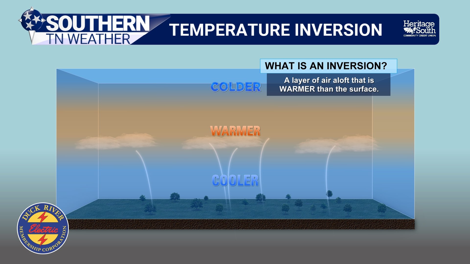
Wind speeds are another important piece of the puzzle. During clear nights with calm or nearly calm winds, the air immediately above the ground can cool much more efficiently than the air several hundred feet above it. This creates what meteorologists call a temperature inversion, a situation in which temperatures actually INCREASE with height through a portion of the lower atmosphere rather than decreasing as they normally do. Stronger winds can disrupt this inversion by mixing the colder air near the surface with relatively warmer air above it, limiting how far surface temperatures fall overnight.
After sunrise, the ground begins warming again, eventually weakening and breaking down that temperature inversion. As atmospheric mixing increases, some of the relatively warmer air above the surface is mixed downward, contributing to a rapid temperature recovery during the morning hours. This is one reason temperatures can climb particularly quickly between approximately 8 AM and noon following a cold, clear night.
Our ongoing drought conditions can also influence daytime heating. When soil contains plenty of moisture, some of the incoming solar energy is used to evaporate water rather than directly warming the surface. When the ground is drier, a greater portion of that energy can go toward heating the surface and surrounding air. Although the recent rainfall provided some much-needed drought relief, many areas across Southern Middle Tennessee are still dealing with moisture deficits, which can contribute to more efficient daytime heating under sunny skies.
Why Your Location Can Make a BIG Difference
One of my favorite aspects of forecasting temperatures across Southern Middle Tennessee is just how much our local geography influences the weather. Between the rolling hills of the Highland Rim, the lower elevations of the Central Basin, and the higher terrain of the Cumberland Plateau, there's plenty of opportunity for significant temperature differences across relatively short distances.
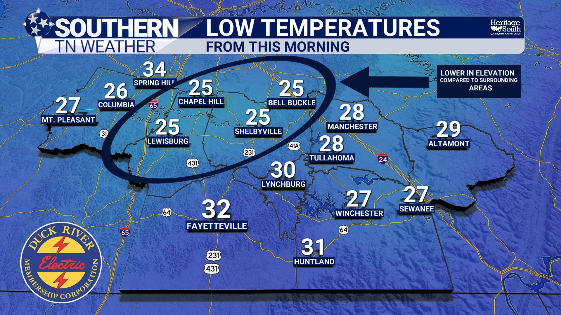
During clear, calm nights, colder and denser air tends to drain downhill and accumulate in sheltered valleys, hollows, and other low-lying areas. This process, known as cold-air drainage, can result in temperatures that are several degrees colder than those observed on nearby hilltops. Communities around Normandy, Wartrace, and Bell Buckle, for example, can experience particularly efficient nighttime cooling in sheltered locations when atmospheric conditions are favorable.
Imagine two hypothetical weather stations located just a few miles apart. One is situated on an exposed hilltop, while the other is located in a sheltered valley. By sunrise, the hilltop station might report a temperature of 34 degrees, while the valley station has dropped to 24 degrees. Once the sun comes up and atmospheric mixing increases, both locations could eventually warm to around 63 degrees. Despite recording nearly identical afternoon highs, the valley experienced a daily temperature swing of 39 degrees compared to just 29 degrees on the hilltop!
This is one reason forecasting overnight low temperatures can sometimes be more challenging than forecasting afternoon highs across our region. During the daytime, atmospheric mixing helps reduce some of those localized temperature differences. At night, however, that mixing can become considerably weaker, allowing our local terrain to have a much greater influence on temperatures.
It's also worth mentioning that we're currently approaching the shortest days of the year. Here in Southern Middle Tennessee, we're experiencing roughly 14 hours between sunset and sunrise, giving the Earth's surface a substantial amount of time to lose heat overnight. While the sun isn't nearly as strong as it is during the summer months, we can still experience considerable daytime warming when skies remain clear and a relatively mild air mass is in place.
A Gradual Warming Trend Continues This Week
Now, let's bring all of this back to our forecast for Southern Middle Tennessee, because this week's weather pattern is an excellent example of everything we've discussed! Following our first widespread hard freeze of the season this past weekend, high pressure will continue influencing our weather through much of the upcoming week. Overnight temperatures will remain rather chilly initially, but afternoon temperatures will gradually climb well above what we experienced just a few days ago.
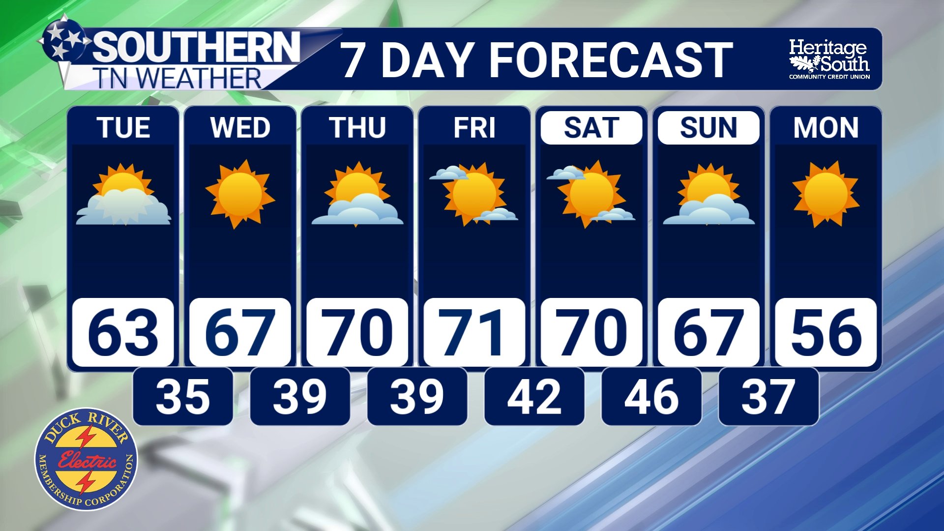
Tonight, temperatures are expected to fall into the upper 20s and lower 30s across much of Southern Middle Tennessee under clear skies and light winds. Another round of widespread frost is likely, with some patchy fog possible near bodies of water. By Tuesday afternoon, however, temperatures should recover into the lower to middle 60s under mostly sunny skies, giving many communities another daily temperature swing exceeding 30 degrees.
As we progress through the middle and latter portions of the week, both afternoon highs and overnight lows will gradually moderate. By Thursday morning, lows should generally be in the upper 30s and lower 40s, making even patchy frost increasingly unlikely. Afternoon highs will climb into the middle and upper 60s before potentially reaching the lower 70s in some communities by Friday and Saturday. Considering our average high temperature for this time of November is around 60 degrees, we'll be running a little ABOVE average by the end of the week.
Unfortunately, there isn't much to get excited about in the rainfall department. High pressure and upper-level ridging will continue supporting generally dry conditions through at least Saturday, which isn't particularly encouraging considering our ongoing drought situation. We're still watching the possibility of a cold front approaching the region by Sunday, which could introduce at least a slight opportunity for rainfall. However, I'm not overly impressed with the signal for meaningful precipitation at this point, and there's still plenty of time for the forecast to change.
The Bottom Line 🧾
The difference between our daily high and low temperatures is known as the diurnal temperature range.
Clear skies, dry air, and light winds favor efficient overnight cooling and substantial daytime temperature recovery.
Sheltered valleys can experience significantly larger temperature swings than nearby hilltops due to cold-air drainage.
Temperature swings of 30–40 degrees are possible across portions of Southern Middle Tennessee early this week.
Overnight temperatures will gradually moderate, with frost becoming increasingly unlikely by Thursday morning.
Afternoon highs will climb into the upper 60s and potentially lower 70s by Friday and Saturday.
Mostly dry conditions continue through at least Saturday, with a slight chance of rainfall returning Sunday.
📰 Reminder: The Southern Tennessee Weather Blog, presented by Heritage South Community Credit Union, is updated Monday through Friday with fresh, locally tailored forecasts you can trust
