

The Southern Tennessee Weather Blog is proudly presented by Heritage South Community Credit Union.
We Help When Others Won’t!
Visit https://www.heritagesouth.org/ today to see how HSCCU can help YOU!
If you've followed my weather forecasts for any length of time, you've probably heard me mention the jet stream on numerous occasions. Whether we're discussing an upcoming severe weather event, the potential for winter weather, an extended period of dry conditions, or even a dramatic change in temperatures, the jet stream is almost always an important part of the conversation. But what exactly is it, why does it exist, and how does something occurring tens of thousands of feet above our heads have such a significant influence on the weather we experience here in Southern Middle Tennessee?
One of the things I find particularly fascinating about meteorology is how interconnected our atmosphere is. Atmospheric disturbances thousands of miles away over the Pacific Ocean can eventually influence whether we're dealing with sunshine, thunderstorms, or even snow here in Tennessee several days later. Much of that connection can be attributed to the large-scale circulation of our atmosphere, with the jet stream playing a particularly important role.
Today, we're going to take a deeper dive into the science behind the jet stream before discussing how our current upper-level weather pattern is influencing our forecast heading into the upcoming weekend!

What Is the Jet Stream, and Why Does It Exist?
The jet stream is essentially a relatively narrow band of strong winds located near the top of the troposphere, the lowest layer of Earth's atmosphere and the layer in which most of our weather occurs. These winds are typically found at altitudes between approximately 25,000 and 45,000 feet, although their exact altitude varies depending on their location, the season, and the surrounding atmospheric conditions. Wind speeds within the jet stream frequently exceed 100 MPH and can occasionally surpass 200 MPH!
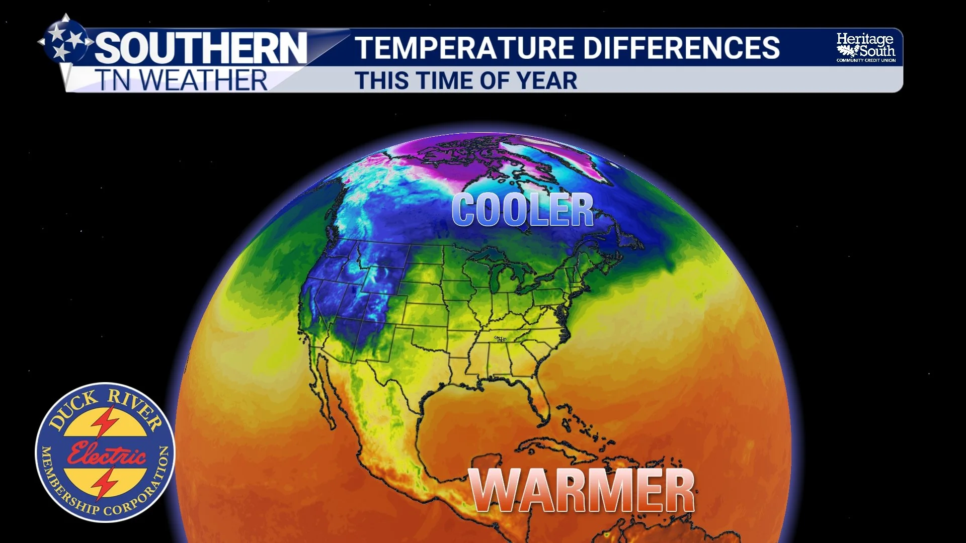
To understand why the jet stream exists, we first need to understand that the Earth is heated unevenly by the sun. Areas near the equator receive more direct solar radiation throughout the year, while the polar regions receive sunlight at a much lower angle. This creates a substantial temperature difference between the warmer tropical regions and the colder polar regions, particularly during the winter months.
Warm air columns are generally thicker than cold air columns because warmer air expands and is less dense. As a result, pressure decreases more slowly with height within a warm air column than within a cold air column. This creates horizontal pressure differences in the upper atmosphere, resulting in a force that accelerates air from areas of higher pressure toward areas of lower pressure.
However, because the Earth is rotating, moving air is deflected by what we call the Coriolis effect. In the Northern Hemisphere, this deflection occurs toward the right of the direction of motion. Rather than simply flowing directly from the warmer tropical regions toward the colder polar regions, the upper-level winds tend to flow from west to east as the pressure gradient force and Coriolis effect approach a balance.
Meteorologists also use a concept known as the thermal wind relationship to describe how horizontal temperature differences influence changes in wind speed and direction with height. Generally speaking, the stronger the horizontal temperature gradient, the greater the vertical wind shear associated with it. This helps explain why particularly strong upper-level winds develop near the boundaries separating contrasting air masses.
It's important to understand that the jet stream isn't a single, continuous ribbon of wind flowing around the entire planet at the same speed and altitude. Its strength, width, altitude, and position are constantly changing as the atmosphere responds to differences in temperature, pressure, and the movement of large-scale weather systems.
The Polar and Subtropical Jet Streams
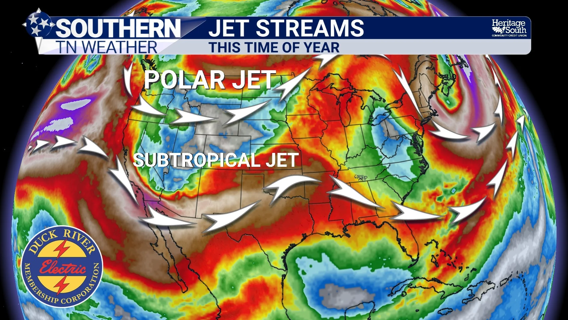
There are two primary types of jet streams that meteorologists frequently discuss when forecasting weather across the United States: the polar jet stream and the subtropical jet stream. While both generally flow from west to east, they develop through somewhat different atmospheric processes and can influence our weather in different ways.
The Polar Jet Stream
The polar jet stream generally develops in the middle to higher latitudes, where strong horizontal temperature gradients exist between colder polar air and warmer air farther south. This jet stream is closely associated with the development and movement of many of the low-pressure systems and cold fronts that affect Southern Middle Tennessee throughout the year.
During the winter months, the temperature contrast between the Arctic and the lower latitudes becomes particularly pronounced, allowing the polar jet stream to become stronger on average. Its position also tends to shift farther south during the colder months of the year, bringing it into closer proximity to the southeastern United States.
When the polar jet stream develops a substantial southward dip, it can help establish an atmospheric circulation pattern favorable for transporting colder air into our region. Conversely, when it retreats farther north, we're often able to experience milder conditions as warmer air becomes established across the southern United States.
The Subtropical Jet Stream
The subtropical jet stream is typically located farther south and at a higher altitude than the polar jet stream. Its formation is closely associated with the large-scale circulation of air within the tropics, particularly the poleward movement of air in the upper branch of the Hadley circulation and the conservation of angular momentum.
The subtropical jet stream can be especially important when forecasting winter weather across the southern United States because disturbances traveling within it can contribute to the development of storm systems across the southern portion of the country.
When disturbances associated with the subtropical jet interact favorably with colder air and atmospheric disturbances associated with the polar jet, the resulting weather pattern can sometimes support significant rainfall, winter storms, or even severe weather. Meteorologists often refer to the interaction and consolidation of upper-level disturbances within separate branches of the atmospheric flow as phasing.
Why Does the Jet Stream Develop Ridges and Troughs?
If you've ever looked at one of the upper-level weather maps I share during my forecast discussions, you've probably noticed that the atmospheric flow rarely follows a perfectly straight path from west to east. Instead, it often contains large northward bulges and southward dips. These large-scale meanders are associated with atmospheric waves known as Rossby waves, which develop in part because the influence of Earth's rotation varies with latitude.
A relatively straight west-to-east atmospheric flow is referred to as zonal flow. Under this type of pattern, weather systems generally progress eastward without large northward or southward excursions. While zonal flow doesn't necessarily guarantee quiet weather, it often limits the magnitude of prolonged temperature extremes compared to a highly amplified pattern.
When the atmospheric flow becomes more amplified, we begin seeing larger northward and southward excursions, commonly referred to as ridges and troughs.
An upper-level ridge is an elongated area of relatively higher geopotential heights, often associated with warmer air columns. Ridges frequently favor sinking air, fewer clouds, and warmer temperatures, although their exact influence depends on their position and the surrounding atmospheric pattern. When a strong ridge remains established over the southeastern United States for an extended period, it can help divert active weather systems away from our region, contributing to prolonged periods of dry weather.
An upper-level trough, on the other hand, is an elongated area of relatively lower geopotential heights, often associated with colder air columns. Troughs frequently provide opportunities for atmospheric lift, particularly downstream of their axes, and can support the development of clouds, precipitation, and surface low-pressure systems. Depending on their strength, position, and movement, they can also help establish a pattern favorable for significant southward transport of colder air.
The movement and evolution of these waves are particularly important in long-range weather forecasting. If a ridge remains anchored over the southeastern United States, for example, we may continue experiencing above-average temperatures and relatively dry conditions. However, if that ridge weakens or shifts eastward and allows a trough to approach from the west, our weather pattern can change considerably within just a few days.
This is one reason why relatively small differences between computer models in their depiction of the upper-level atmospheric pattern can eventually translate into substantial differences in our local weather forecasts.
The Jet Stream Does More Than Just Steer Weather Systems
Although the jet stream is frequently described as an atmospheric highway that helps guide weather systems, its influence goes far beyond simply determining where those systems travel. Variations in wind speed and direction within the jet stream can influence vertical motion throughout the atmosphere, which is particularly important when forecasting the development and strengthening of storm systems.
Within the jet stream, localized regions of particularly strong winds are known as jet streaks. As air enters and exits these regions, adjustments to the balance between atmospheric forces can create areas of upper-level divergence and convergence. In favorable locations, upper-level divergence can help support rising air beneath it and falling surface pressures, allowing a nearby low-pressure system to strengthen.
In an idealized, relatively straight jet streak in the Northern Hemisphere, the left exit region and right entrance region are commonly associated with upper-level divergence and favorable conditions for rising air. However, the curvature of the jet stream, the surrounding atmospheric temperature distribution, and interactions with other weather features can make this considerably more complicated in reality.
During severe weather events across Southern Middle Tennessee, meteorologists closely monitor the strength and position of the jet stream because it can contribute to both atmospheric lift and vertical wind shear. Vertical wind shear, which describes changes in wind speed and/or direction with height, is an important ingredient in the development of organized thunderstorms, including supercells. When sufficient moisture, atmospheric instability, and lift are also present, strong upper-level winds can contribute to an environment favorable for severe weather.
The jet stream is equally important during the winter months. Its position can influence where surface low-pressure systems develop, how much moisture is transported northward from the Gulf, and whether colder air remains established across our region. As we discussed in yesterday's educational weather blog, even relatively small changes in the atmospheric temperature profile can determine whether we experience snow, sleet, freezing rain, or just plain rain. Changes in the large-scale upper-level pattern can ultimately influence all of those ingredients!
How Does the Jet Stream Change Throughout the Year?
Because the jet stream is closely tied to the distribution of heat across our planet, it undergoes considerable seasonal changes. During the summer months, the temperature contrast between the polar regions and lower latitudes generally weakens, and the polar jet stream tends to retreat farther north. This is one reason the more organized storm systems associated with strong upper-level disturbances frequently track farther north during the summer, while much of the southeastern United States experiences heat, humidity, and more locally driven afternoon thunderstorms.
As we transition into fall and winter, the polar regions begin cooling considerably faster than the lower latitudes. The strengthening temperature gradient generally supports stronger upper-level winds, while seasonal changes in atmospheric circulation favor a southward migration of the polar jet stream. This brings Southern Middle Tennessee into closer proximity to the more active belt of westerly winds, increasing our opportunities for stronger cold fronts, organized storm systems, and occasionally winter weather.
During the spring months, we're often dealing with an especially interesting combination of a still-active jet stream and increasing warmth and moisture moving northward from the Gulf. This overlap is one of the reasons spring is traditionally our most active severe weather season across Southern Middle Tennessee, although significant severe weather can also occur during the fall and winter months.
Larger-scale atmospheric and oceanic patterns, such as El Niño and La Niña, can also influence the average strength and position of the jet streams over extended periods. These patterns don't determine our weather on any individual day, but they can influence the overall tendencies of our weather pattern throughout an entire season.
Bringing It Back Home: Our Southern Middle Tennessee Forecast
Our current weather pattern is an excellent example of how the upper-level atmospheric flow can influence our day-to-day weather. An upper-level ridge remains established across the eastern half of the United States, with an area of surface high pressure positioned to our northeast. This combination will continue supporting relatively quiet weather across Southern Middle Tennessee through the remainder of the workweek, along with our ongoing warming trend.
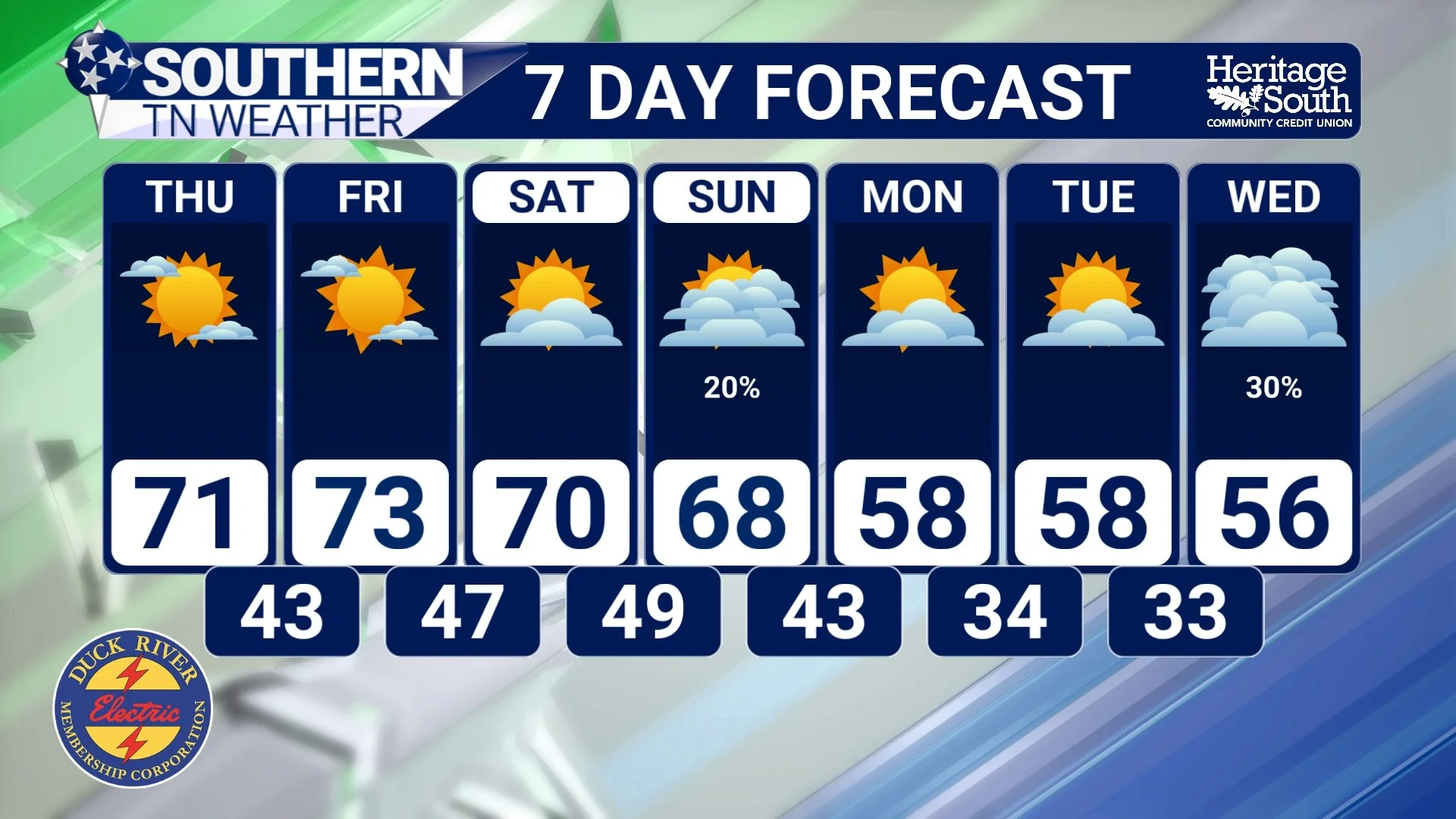
Temperatures this afternoon will climb into the middle and upper 60s under mostly sunny skies, putting us several degrees ABOVE our average high of around 60 degrees for this time of year. We'll continue warming into Thursday and Friday, with afternoon highs approaching 70 degrees across much of the region. Some communities could even reach the lower 70s! Overnight temperatures will also gradually moderate, with lows generally in the middle 30s to lower 40s tonight before climbing into the upper 40s and lower 50s heading into the weekend. A little patchy frost in our traditionally colder locations can't be completely ruled out tonight, but widespread freezing temperatures are becoming increasingly unlikely over the next few mornings.
As we head into the weekend, our upper-level weather pattern will begin undergoing some changes. The ridge will lose some of its influence as disturbances embedded within the upper-level flow approach from the west. A relatively weak disturbance could bring an increase in cloud cover on Saturday, along with a very small chance for a light rain shower. However, Saturday is still looking predominantly dry, with afternoon temperatures generally in the middle and upper 60s.
Our better opportunity for rainfall will arrive Sunday as an area of low pressure tracks through the Great Lakes region, helping push a cold front toward Southern Middle Tennessee. Rain chances remain relatively low, generally around 10–30% across the region, with the primary window for a few showers appearing to be Sunday afternoon and evening, potentially lingering into early Monday in some locations.
Unfortunately, moisture availability and the weakening nature of the approaching upper-level disturbance remain limiting factors. I'm still not overly impressed with our prospects for a widespread, soaking rainfall this weekend, and many communities could remain completely dry. Atmospheric instability also appears quite limited, so the potential for thunderstorms remains very low.
Behind the cold front, another area of Canadian high pressure will build southward into the central United States, bringing cooler and generally drier conditions back into Southern Middle Tennessee early next week. Afternoon highs will return to the 50s in many communities by Monday or Tuesday, with overnight temperatures eventually dipping back into the 30s.
I'll also continue monitoring the evolution of the upper-level pattern heading into Thanksgiving week and the final days of November. There have been indications that our weather pattern could eventually become more active, but it's still too early to confidently pinpoint the timing, strength, or rainfall potential of any additional storm systems.
The Bottom Line 🧾
The jet stream is a band of strong upper-level winds influenced by temperature gradients, Earth's rotation, and large-scale atmospheric circulation.
Its position, strength, and shape play important roles in the development and movement of storm systems.
Upper-level ridging will continue supporting dry and increasingly warm conditions through Friday.
Afternoon highs near 70 degrees are expected Thursday and Friday.
Low rain chances return this weekend, with Sunday currently offering our better opportunity.
A widespread, soaking rainfall is NOT currently anticipated this weekend.
Cooler temperatures return behind Sunday's cold front, with highs back into the 50s early next week.
📰 Reminder: The Southern Tennessee Weather Blog, presented by Heritage South Community Credit Union, is updated Monday through Friday with fresh, locally tailored forecasts you can trust
