
A Look “Under the Hood” at Next Week’s Weather Pattern
This Weekend - Still Quiet and Boring (In a Good Way)
Above-average temperatures and mostly sunny skies will continue to dominate the forecast this weekend. Highs on Saturday and Sunday will climb into the low to mid-70s, which is a solid 10–15 degrees above normal for mid-November. A weak cold front will slip through Saturday night, bringing Increasing clouds (mainly overnight) and Gusty winds Saturday and Sunday (25–30 MPH gusts). It’s not a bad idea to secure lightweight outdoor items. before bed tonight. Because this is a very weak front, significant rainfall is not expected. A brief patch of drizzle will be possible.
If you're not in a “learning mood” this afternoon, feel free to stop here — because we’re about to look under the hood of next week’s weather pattern.
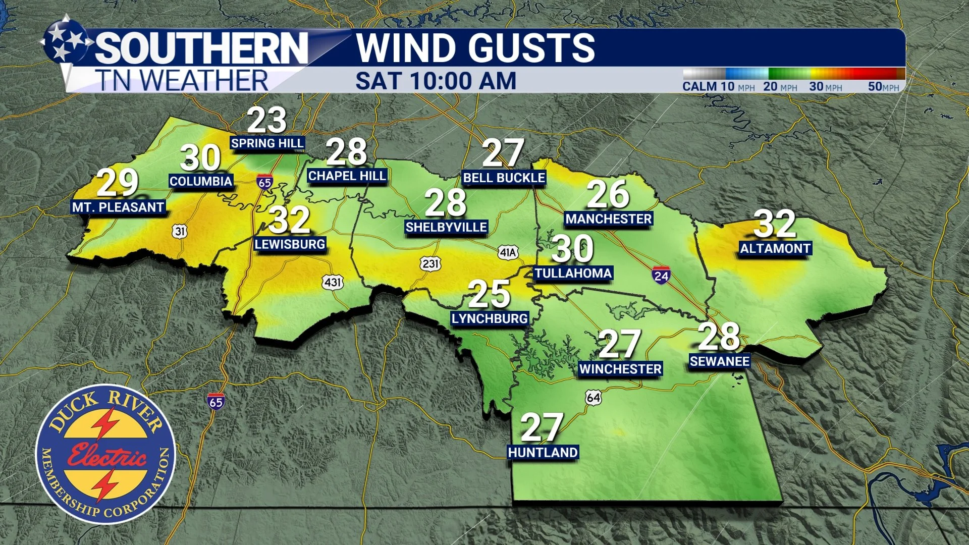
HRRR Model Wind Gusts Tomorrow
Looking Under the Hood: Next Week’s Setup
Next week becomes much more interesting, especially from Thursday into Friday. We will have a weaker system pass through on Tuesday with light rain, but the real focus is late next week.
Today, we’re taking a deeper dive into two major atmospheric clues meteorologists use to anticipate storm chances:
Jetstream / 500 mb pattern
Vertical velocity (rising air) at 700 mb
These two pieces tell us a lot about next week’s potential.
1. The Jetstream Setup – Storm Fuel From Above
In the graphic below, we’re looking at the 500 mb level, which is roughly 18,000 feet above sea level. Winds at 500 MB and the Jetstream (white) is shown. This is where we see the structure of the atmosphere — including the Jetstream, troughs, and ridges.
Quick refresher:
• Troughs = storm systems, lift, unsettled weather
• Ridges = calm, sunny, stable weather
Right now, we’re under a large ridge (hence the warm, quiet weather). But late next next week? A trough digs into the ARLATEX and Missouri region. Meteorology 101 tells us the best rising air and storm development usually occurs just EAST (or to the right) of a trough axis. Guess where that places us on Friday…? Right in the favored zone for showers and storms.
Timing is still fuzzy (and will remain that way for a few more days) but the pattern is what matters here.
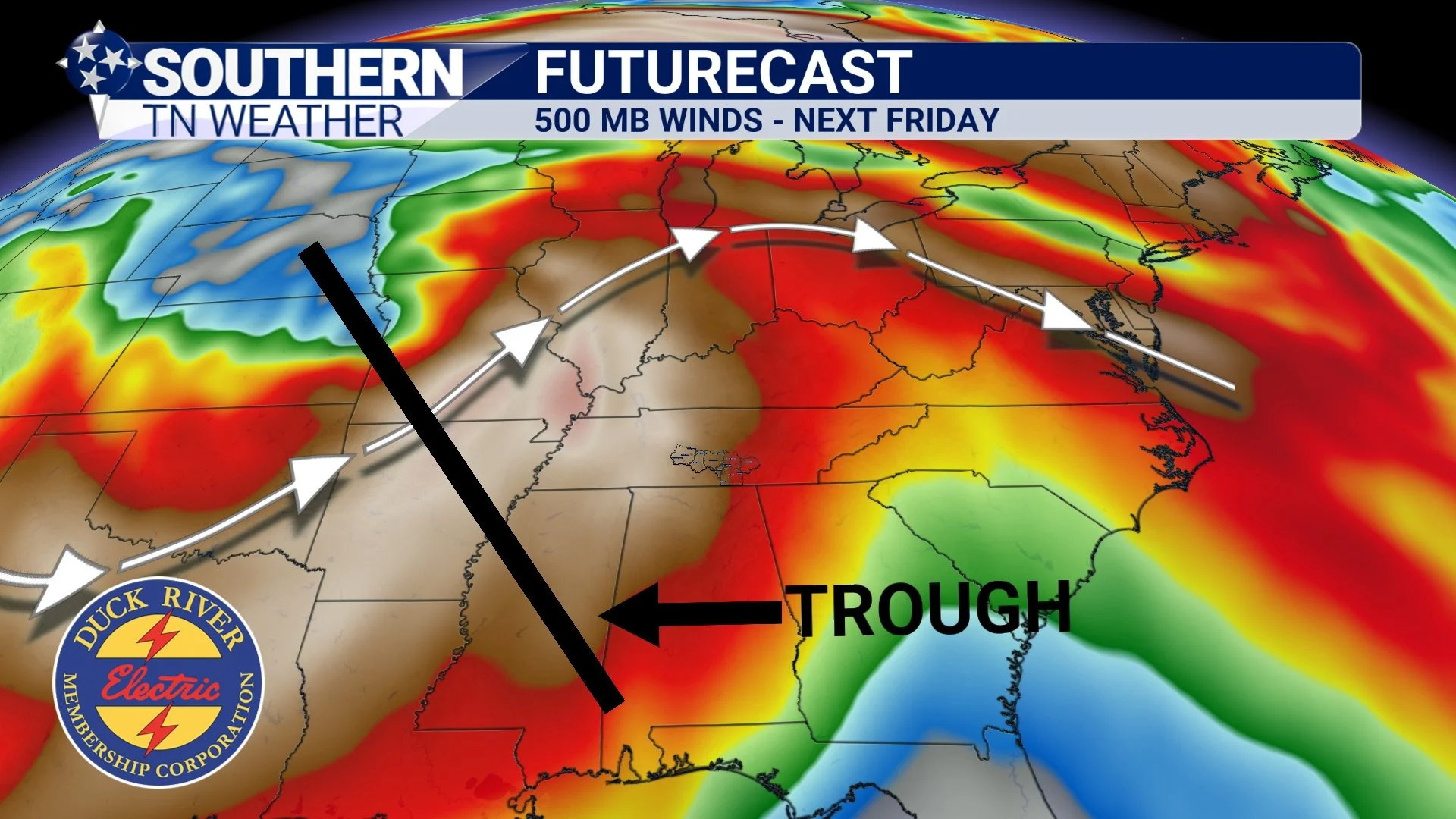
Futurecast 500 MB Trough - Next Friday
2. Vertical Velocity – Rising Air at 700 mb
This next graphic isn’t from my usual software, but it’s still great to illustrate the point. At the 700 mb level (around 10,000 feet up), we can look at vertical velocity, which is essentially a measure of rising air. In simple terms, the more velocity = more rising air = better storm support… And next Friday, we have a LOT of it overhead — lining up exactly with the trough we talked about in the previous section.
See the connection?
• Trough to our west ➜ Rising air to the east
• Rising air ➜ Better storm chances
• Both show up at the same time next Friday
These kinds of pattern connections are one of the coolest parts of meteorology. It’s the atmosphere leaving us clues long before the details are clear. Of course, there are other pieces we monitor too (moisture, instability, jet streaks, surface features)… but I wanted to show you two of the big ones today.

Vertical Velocity… or rising air next Friday
Putting It All Together
So, what does all of this mean for us?
• We’re watching next Friday closely for showers and possibly a few thunderstorms.
• The official NWS forecast calls for 1–2 inches of rain areawide by Saturday morning.
• A weaker system Tuesday brings light rain.
• The late-week system is the one to watch.
• Still too early for specifics like timing or severity — this is the “pattern recognition” stage.
Since the weather stays quiet for the next few days, I thought it would be a great opportunity to take you behind the scenes and show some of the tools we use to anticipate stormy periods long before they arrive. Next Friday looks to be our busiest weather day next week.
The Bottom Line 🧾
• Warm, mundane weather through the weekend
• An active pattern returns next week
• Two rain systems: light Tuesday, stronger Thursday–Friday
• 1–2 inches of rainfall possible late week
• A few storms are possible Friday — too early for details
• More specifics will come Monday as timing becomes clearer
📰 Reminder: Our Southern Tennessee Weather Blog is updated Monday through Friday with fresh, locally tailored forecasts you can trust.
Be sure to follow along so you never miss an update!