
Multiple Rain Chances This Week
Overview
It was a chilly start to the morning across Southern Middle Tennessee, with many communities dipping below freezing once again. Afternoon highs will reach the mid-60s, but today will likely be our last day in the 60s until the weekend. A warm front will lift through the region early Tuesday, shifting our winds out of the south and pulling warmer, more humid air into the area. This will set the stage for multiple rounds of showers and storms through the next 7 days.
Today’s blog breaks down the two main rain chances:
Tuesday night
Friday
Let’s dive into the details.
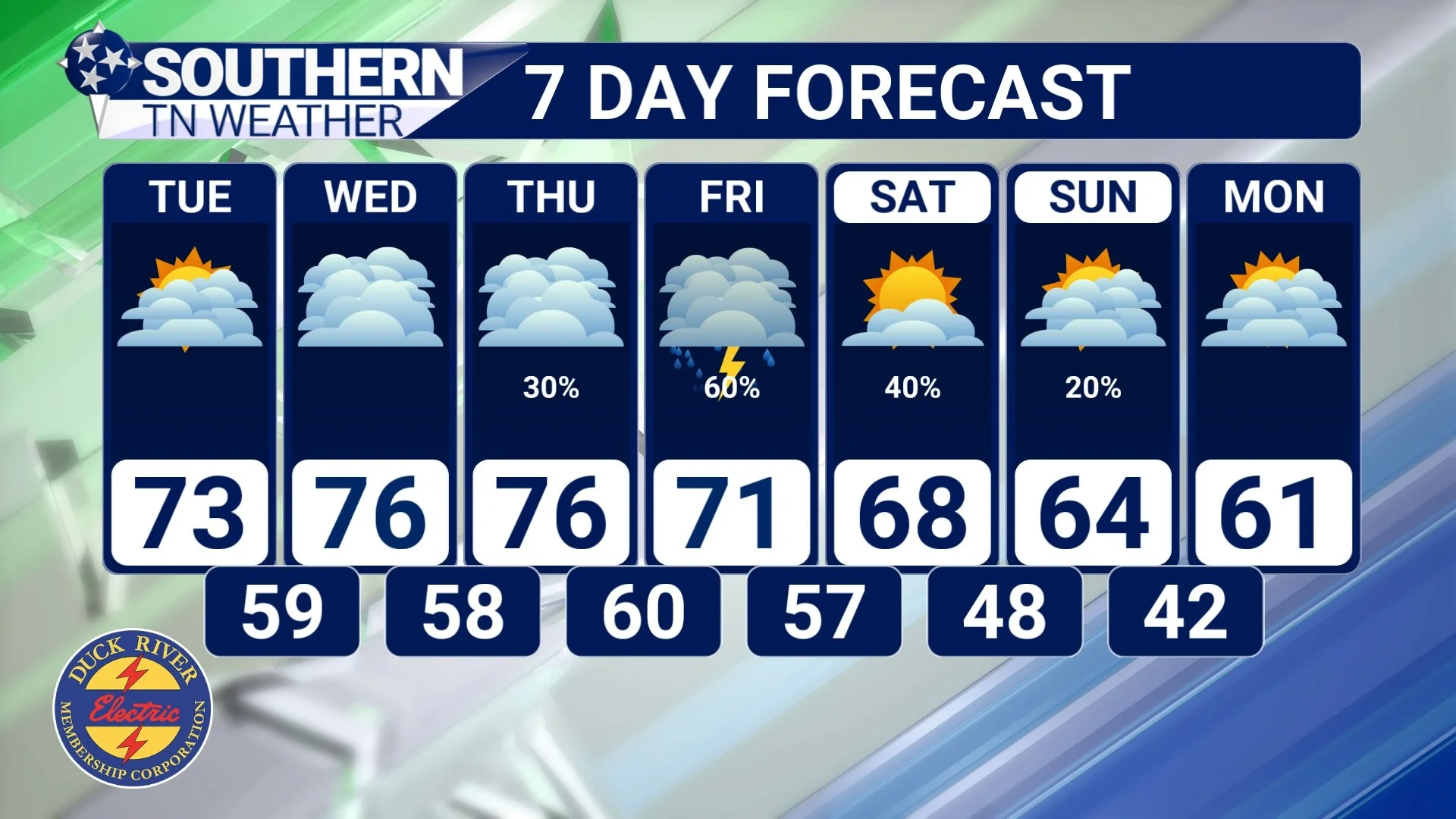
7-day forecast
Rain Chance #1: Tuesday Night Into Wednesday
Our first weather system arrives Tuesday evening as moisture increases ahead of a weak low-pressure center to our northwest. I’ll be honest — this round is not looking impressive in terms of widespread heavy rainfall. Futurecast data shows only a few spotty showers developing after dark Tuesday. Most of the activity Tuesday will stay north of us, closer to the surface low. That’s where a few stronger storms could develop, but that risk stays out of our area. Still, I think we’ll be dealing with a few showers (and maybe a rumble of thunder) Tuesday night into Wednesday morning. Outside of rain chances, cloud cover will thicken late tonight and throughout Tuesday, leaving us with partly to mostly cloudy skies much of the day.
For us:
Rain chances increase to around 50% after 6 PM
A few rumbles of thunder are possible
Meaningful activity ends before sunrise Wednesday
Clouds linger much of Wednesday, with scattered light showers possible
Rain totals: Up to 0.5 inches through Wednesday morning. As always, some locations could see more while others see less.
This is a light, low-impact system for us, but it officially kicks off our wetter pattern for the week.

Futurecast - Tuesday night
Rain Chance #2: Friday Into Saturday – The Main Event
Wednesday looks dry, and Thursday will be mostly dry as well. I included a 30% rain chance for Thursday to account for a few passing showers, but similar to Tuesday, most of the activity will be off to our north. Our big system arrives Friday. A stronger low-pressure system and cold front will approach from the west Friday afternoon, bringing widespread showers and storms into the region. Scattered rain is possible throughout the day, but the best chance will be Friday afternoon through overnight.
This system looks robust, but it’s still too early to determine whether we’ll deal with any strong or severe storms. As always this time of year, the storm fuel (instability) will be the deciding factor — and we’re too far out to know how much moisture we’ll have to work with. Friday is definitely the day to watch, and I’ll have detailed updates later this week.
Once this cold front clears our area:
Temperatures return to the low to mid-60s (seasonable)
We may see a few lingering showers Saturday or Sunday, although no widespread weekend rain is expected (at least right now)
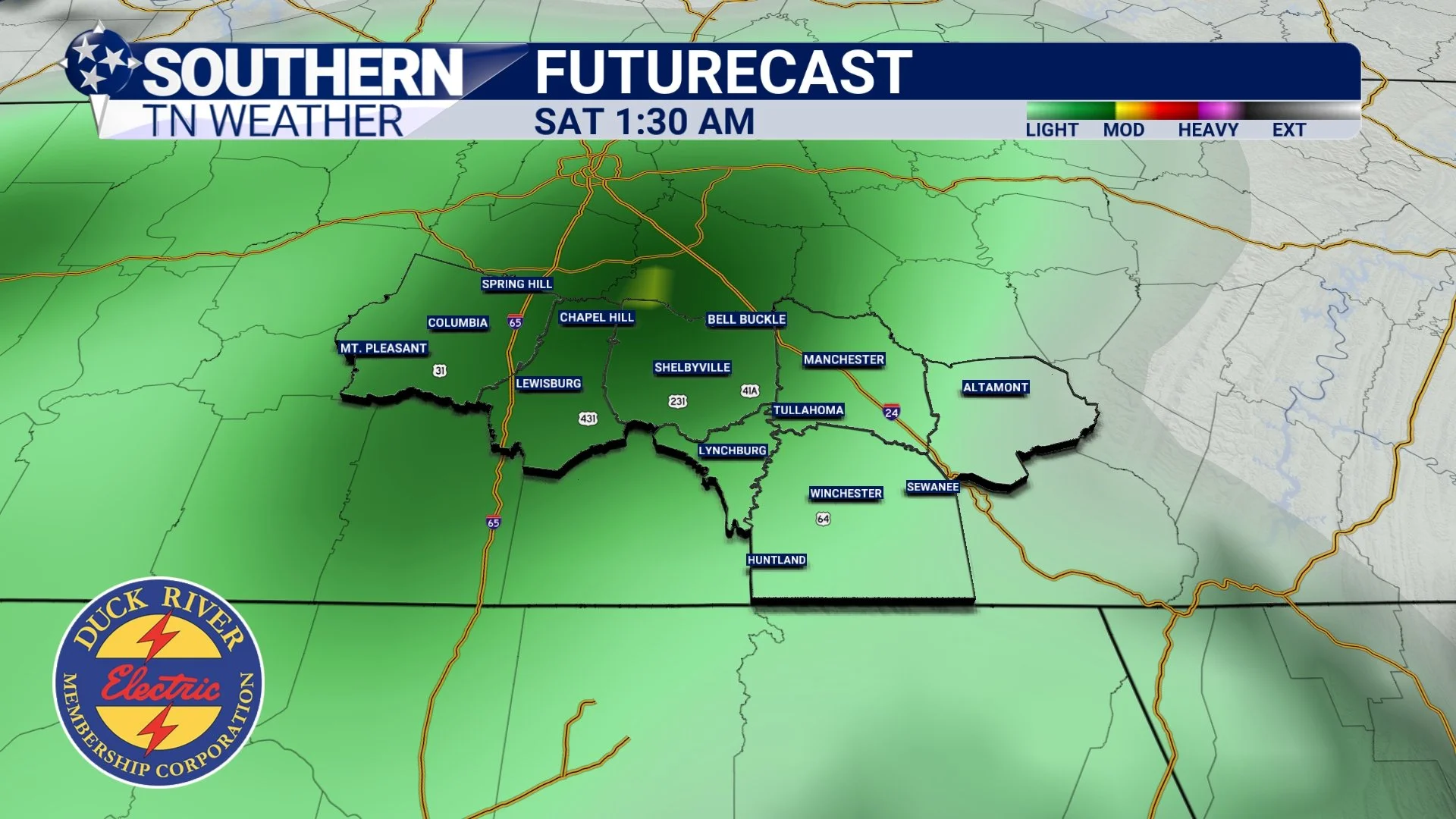
Futurecast - Late Friday night
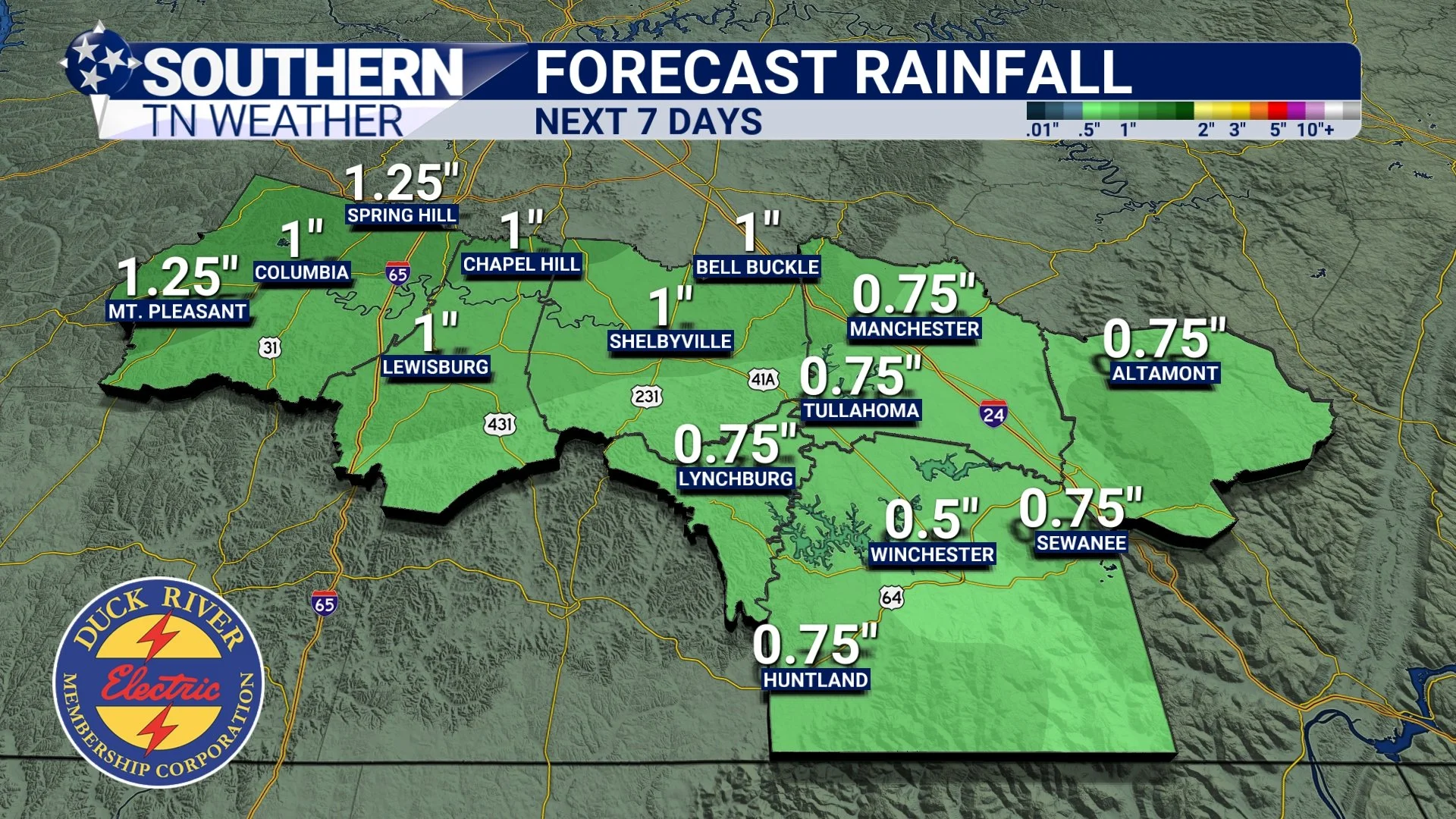
Rainfall Totals Through Saturday
Based on current data, rainfall totals over the next 7 days should fall between 0.5" and 2.0" area-wide.
Most of this will fall Friday into Saturday.
The Bottom Line 🧾
• Today will be our last day in the 60s until Saturday
• First round of showers arrives Tuesday night into Wednesday (light, low impact)
• Mostly dry Wednesday and Thursday
• Stronger system arrives Friday with widespread rain and storms
• Still too early to know if severe storms will occur
• Weekend turns seasonable with only small rain chances
📰 Reminder: Our Southern Tennessee Weather Blog is updated Monday through Friday with fresh, locally tailored forecasts you can trust.
Be sure to follow along so you never miss an update!