
Boring Weather Through the Weekend… Active Pattern Emerges Next Week
Boring weather… but that isn’t a bad thing!
We’re sitting in the mid to upper 60s across Southern Middle Tennessee this Thursday — about 5 to 8 degrees above average for this time of year. High pressure is firmly in control of our local weather pattern, and that will continue straight through the weekend. Highs on Friday, Saturday, and Sunday will climb into the 70s, which is 10 to 15 degrees above normal. It’s pretty wild to think we had highs in the 30s on Monday… and now we’re talking about the 70s. Classic Tennessee weather for Fall.
Rain-Free Until Early Next Week
Thanks to that dome of high pressure, no rain is expected through Sunday. Our next opportunities for precipitation return Monday night into Tuesday, and then again around Thursday or Friday as at least two separate low-pressure systems move through.
Timing will shift as we get closer (it always does) but for now, both the European and American (GFS) models are in good agreement on the overall pattern:
- Quiet through the weekend
- Active, unsettled pattern next week
Weather Prediction Center Highlights Heavy Rain Potential
In the latest Weather Prediction Center (WPC) Medium-Range Hazards Outlook, our area is highlighted for a risk of heavy rainfall on November 20th (next Thursday). Here’s exactly what the WPC had to say:
“As another weather system moves into the High Plains by midweek, more moisture is expected to gather along a front that will stall across the south-central U.S. This could lead to periods of heavy rain and thunderstorms. Some forecast models are showing several inches of rainfall. If this trend continues, there could be a risk for flooding. There is also growing concern for some severe weather starting Wednesday, but details remain uncertain.”
In simpler terms:
Late next week looks active.
Heavy rainfall is possible.
A few severe storms can’t be ruled out, but keep in mind they’re talking about a lot of square footage in the above quote. So they’re just highlighting the overall pattern in the south-central US.
I’m keeping a close eye on potential impacts here in Southern Middle Tennessee, but I’m nowhere near ready to sound the sirens. We’re still a week out.
Potential Rainfall Totals (Early Look)
Below is a look at potential rainfall totals through next Saturday morning from the American weather model. Keep in mind:
This is NOT an official forecast.
All of this rain would fall next week, not the rest of this week or this weekend.
The data will change before we get into the Monday–Friday window of next week.
Still — this gives us a solid idea that next week won’t be boring… We’re recognizing the pattern now, which is the first step of forecasting. Now, we have to watch for trends / updates with the data as we go into the weekend and early next week.
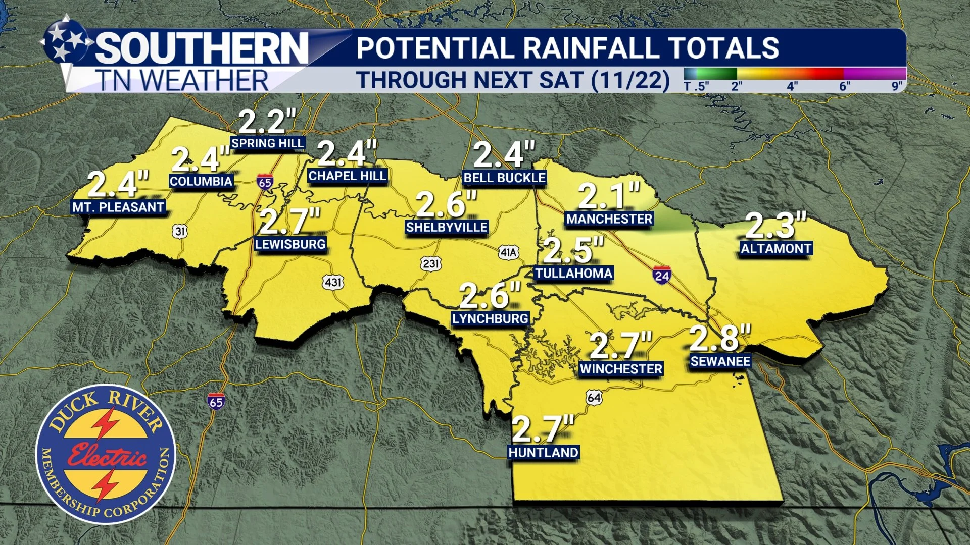
Futurecast rainfall totals through NEXT Saturday.
7-Day Forecast
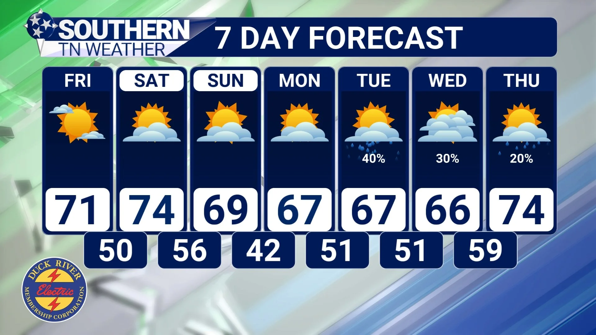
7 Day Forecast
The Bottom Line 🧾
• Mundane weather through the weekend with above-average highs
• An active weather pattern returns next week
• Heavy rainfall possible, especially late week - and maybe a few storms
📰 Reminder: Our Southern Tennessee Weather Blog is updated Monday through Friday with fresh, locally tailored forecasts you can trust.
Be sure to follow along so you never miss an update!