
Tracking The Next Round Of Rain & Heat

The Southern Tennessee Weather Blog is proudly presented by Heritage South Community Credit Union.
We Help When Others Won’t!
Visit https://www.heritagesouth.org/ today to see how HSCCU can help YOU!
After what feels like weeks of talking about severe weather risks, heavy rainfall, flooding concerns, tropical moisture, cold fronts, and popup thunderstorms, Southern Middle Tennessee is finally getting a chance to catch its breath. In fact, today and Wednesday may end up being two of the nicest weather days we've seen all month.
The problem? Summer is about to remind us who's in charge.
A Refreshing Change
If you've spent any time outdoors today, you've probably noticed the difference immediately. The sticky, tropical air that dominated much of last week has been pushed south of the region, allowing much more comfortable air to settle across Southern Middle Tennessee. Dewpoints have fallen into the lower 60s, which may not sound like a big deal, but this time of year it makes all the difference.
Instead of sweating the moment you step outside, temperatures in the upper 70s and lower 80s actually feel pleasant. A weak area of high pressure is currently sliding across the region, keeping skies partly cloudy and rain-free. Quite frankly, if you've been putting off yard work, outdoor projects, or simply enjoying some time outside, today is a great day to do it.
Watch Out For Dense Fog
While the afternoons look fantastic, the mornings may come with a different challenge. Tonight and again Wednesday night, conditions appear favorable for areas of dense fog to develop across Southern Middle Tennessee.
Recent rainfall has left plenty of moisture near the ground, and with light winds and temperatures cooling into the upper 50s and lower 60s, fog should become fairly widespread by daybreak.bSome locations could see visibility drop significantly Wednesday morning. If you're heading to work early, give yourself a little extra time and be prepared for rapidly changing visibility.
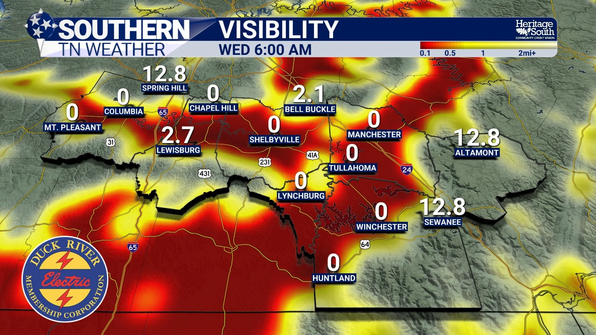
VISIBILITY - WEDNESDAY MORNING
Wednesday Stays Pleasant
The good weather continues Wednesday. Cloud cover may be a little less noticeable compared to today, but most locations should remain dry with highs reaching the lower to middle 80s. Humidity levels will remain manageable, although you'll begin to notice a subtle increase as winds gradually turn back around from the south. That shift in wind direction is an early sign of what's coming later this week.
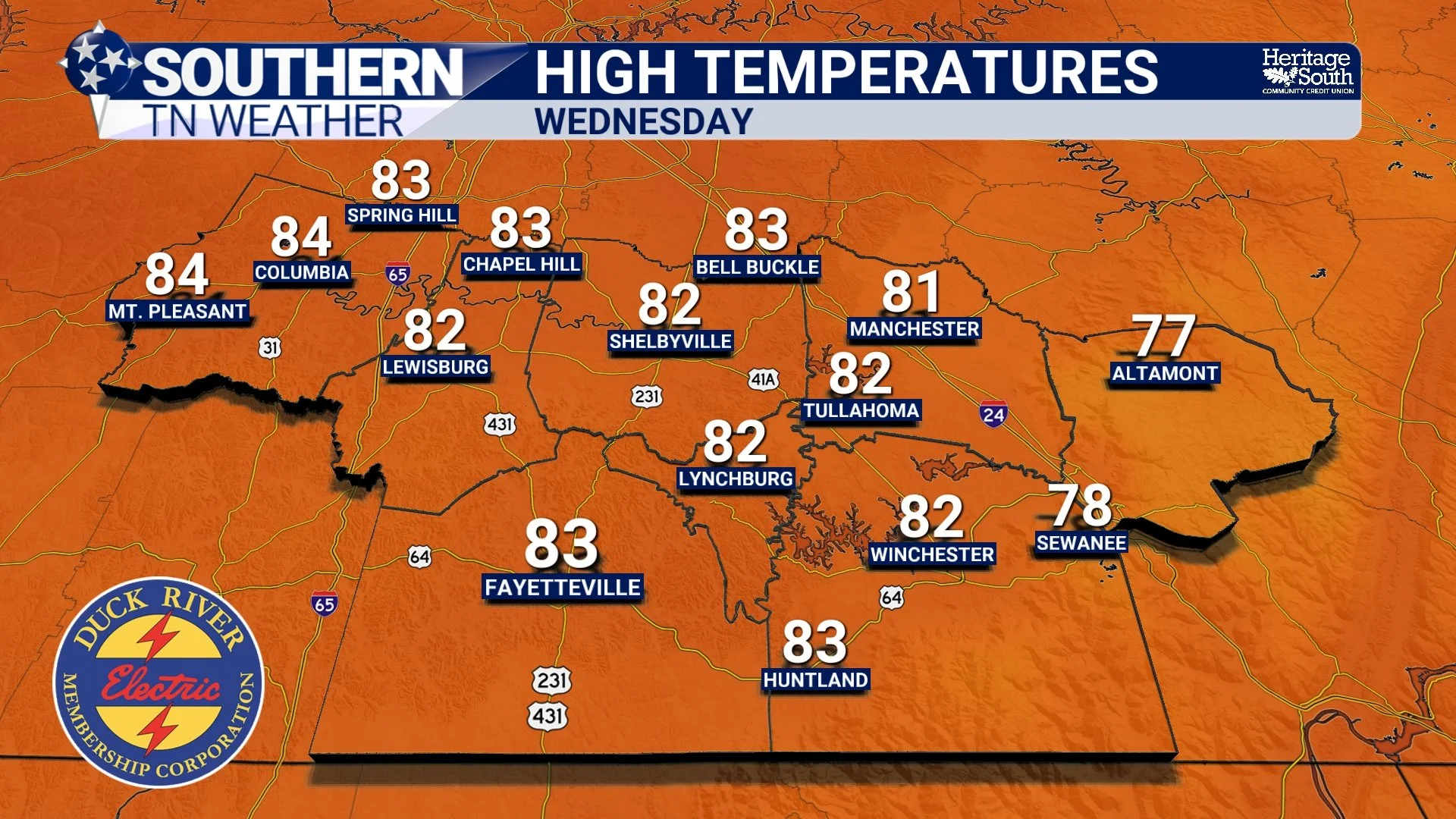
HIGH TEMPERATURES - WEDNESDAY
Rain Chances Return Thursday
Beginning Thursday, our weather pattern starts transitioning back toward a more typical summertime setup. A more west-to-east flow develops across the country, allowing small disturbances to move through the region. At the same time, Gulf moisture begins working northward once again. The result will be the return of isolated to widely scattered shower and thunderstorm chances Thursday through Saturday.
The good news is that rainfall totals currently look fairly modest, with most locations expected to receive less than an inch of rain through the weekend. At this point, widespread severe weather is not expected. Instead, we're looking at the typical summertime variety of storms: scattered, hit-or-miss, and largely driven by daytime heating and passing disturbances.
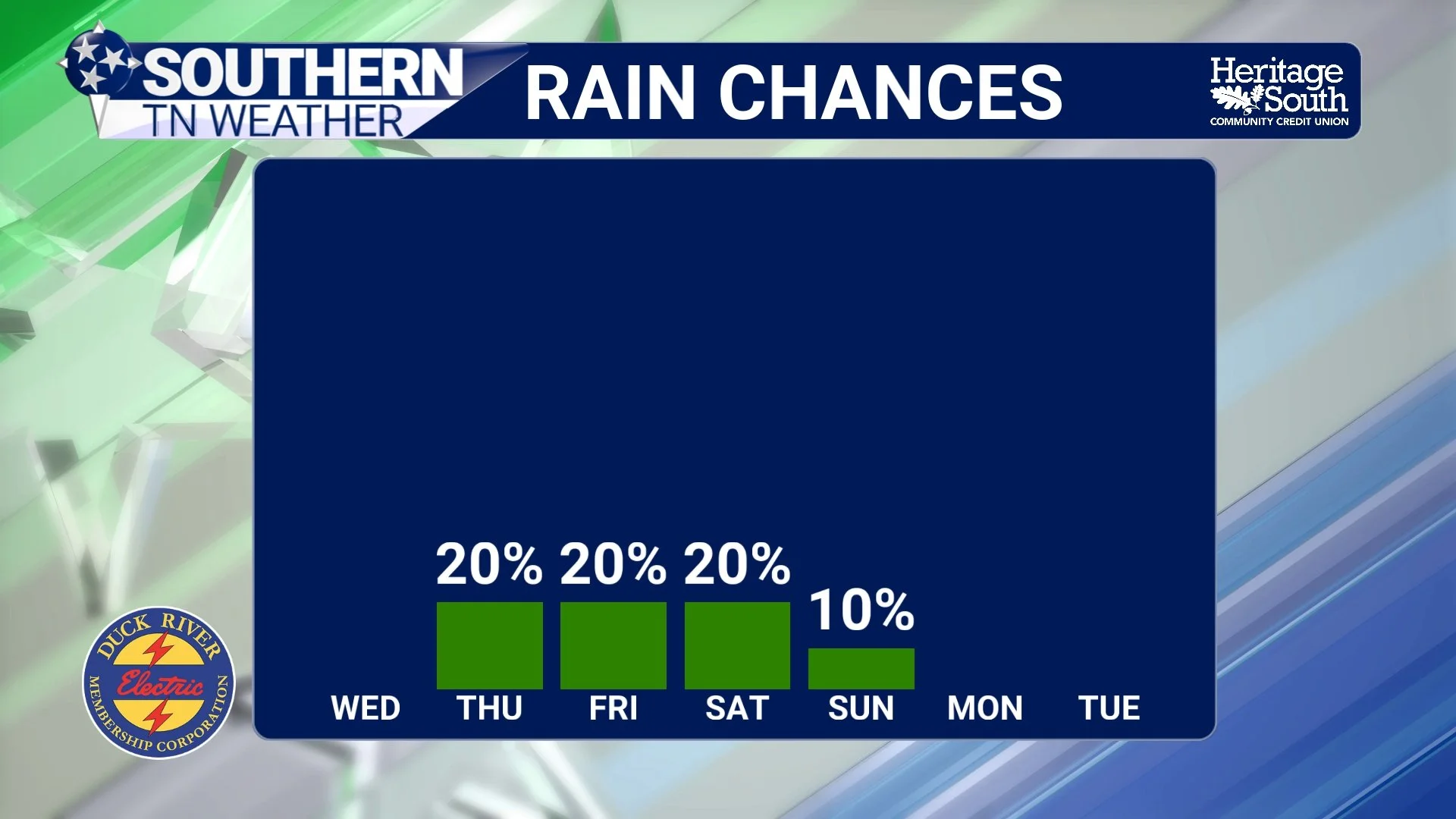
RAIN CHANCES - NEXT 7 DAYS
The Heat Builds This Weekend
While rain chances return, the bigger story may actually become the heat. Temperatures will steadily climb from the middle 80s Thursday into the upper 80s and lower 90s by the weekend. Then comes Sunday and early next week. Forecast guidance continues to show a strong area of high pressure building directly over the southeastern United States. That ridge will act like a lid on the atmosphere, suppressing widespread storm activity while allowing temperatures to climb.
Highs in the middle and upper 90s are becoming increasingly likely by Sunday, Monday, and Tuesday. When you factor in the returning humidity, heat index values will likely exceed 100 degrees across portions of Southern Middle Tennessee. Some areas could approach 105 degrees during the hottest part of the afternoon.
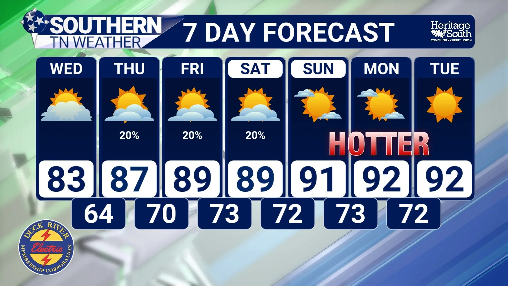
STNWX 7-DAY FORECAST
Looking Ahead
For now, the message is pretty simple… Enjoy today. Enjoy tomorrow.
Because while we're not looking at any major storms in the foreseeable future, we are transitioning away from this brief stretch of comfortable weather and back toward a more typical Tennessee summer pattern. That means warmer temperatures, increasing humidity, occasional afternoon thunderstorms, and eventually our first significant stretch of heat in quite some time.
The Bottom Line 🧾
Pleasant weather continues through Wednesday.
Areas of dense fog are possible Wednesday morning.
Rain chances return Thursday and continue at times through Saturday.
Widespread severe weather is not expected.
Temperatures gradually climb into the upper 80s and lower 90s by the weekend.
The hottest weather arrives Sunday into next week.
Heat index values above 100° appear increasingly likely early next week.
📰 Reminder: The Southern Tennessee Weather Blog, presented by Heritage South Community Credit Union, is updated Monday through Friday with fresh, locally tailored forecasts you can trust.