
Heat Risk Increasing As We Head Into Next Week

The Southern Tennessee Weather Blog is proudly presented by Heritage South Community Credit Union.
We Help When Others Won’t!
Visit https://www.heritagesouth.org/ today to see how HSCCU can help YOU!
After another beautiful day across Southern Middle Tennessee, our weather pattern is about to begin a gradual transition back toward a more typical late-June setup. That means two things: increasing rain chances and increasing heat.
Neither of those changes will happen overnight. In fact, Thursday and Friday still look fairly manageable (minus some popup storms). But by the time we get into the weekend and early next week, the atmosphere will be telling a much different story.
One More Pleasant Day
Today's weather is about as good as it gets for late June in Tennessee. Temperatures have climbed into the lower and middle 80s this afternoon while humidity levels have remained relatively tolerable. A weak area of high pressure remains in control, keeping rain chances at bay and allowing most of us to enjoy a dry day.
Tonight, we'll once again have to watch for areas of fog, but it should remain fairly spotty. Forecast confidence isn't quite as high as previous nights due to increasing cloud cover, but some pockets of dense fog remain possible by daybreak Thursday.
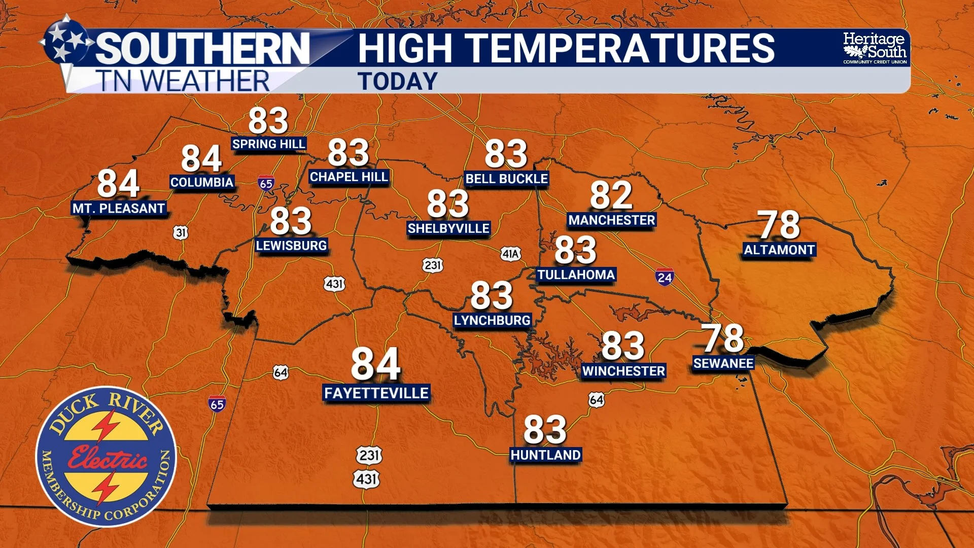
HIGH TEMPERATURES - TODAY
Rain Chances Return Thursday
Beginning Thursday, we'll start seeing the first signs of a more active weather pattern. A weak disturbance moving in from the west may generate a few isolated showers and thunderstorms during the afternoon and evening hours. Coverage should remain fairly limited, and many communities will likely stay completely dry. If you do see rain, it will likely be brief and localized.
The same general setup continues on Friday as additional weak disturbances move through the region. These aren't strong storm systems by any means, but they're enough to generate occasional showers and thunderstorms during the hottest part of the day. At this time, widespread severe weather is not expected, but a few storms could certainly be strong.
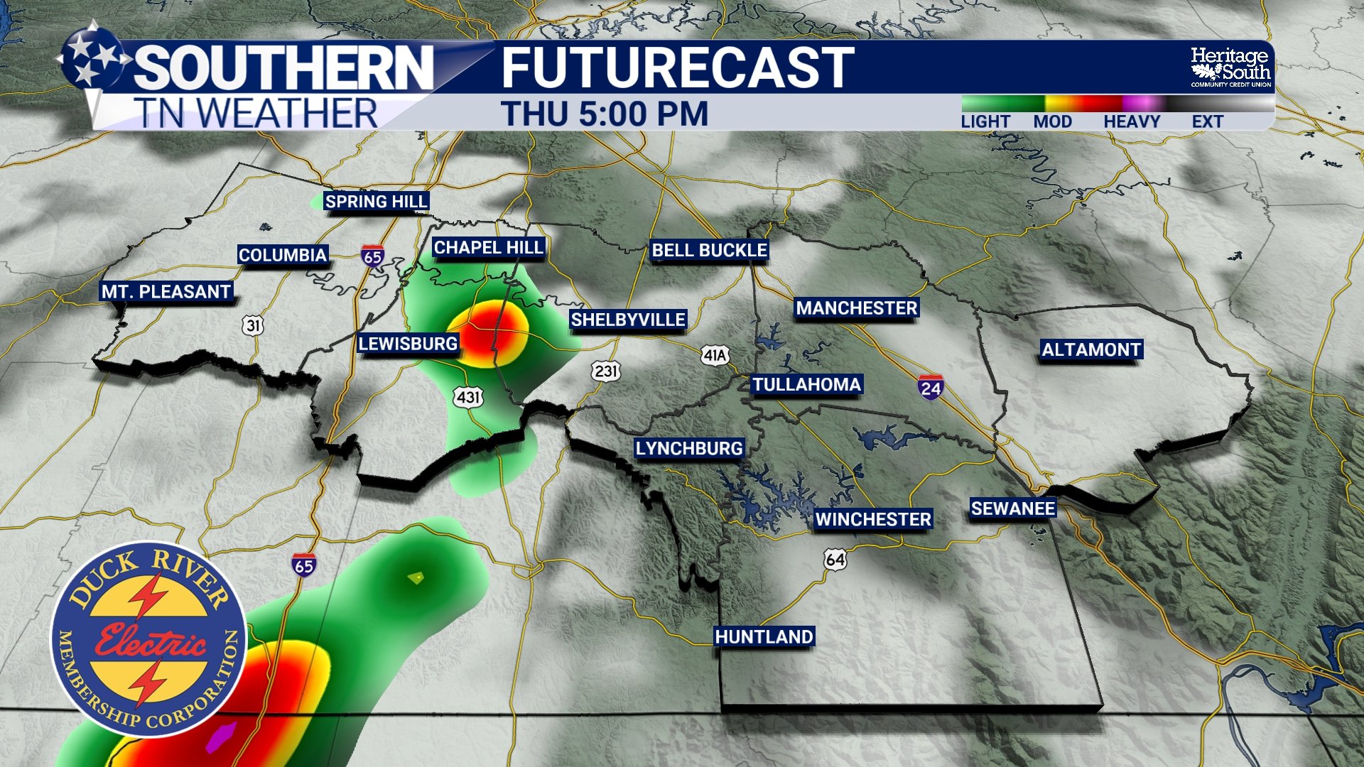
FUTURECAST - THURSDAY EVENING
The Weekend Forecast
By Saturday and Sunday, temperatures begin climbing more aggressively as a stronger upper-level ridge starts building across the southeastern United States. Highs should reach the upper 80s and lower 90s both days, while humidity levels continue increasing. We'll still carry daily chances for showers and thunderstorms, especially during the afternoon and evening hours. The highest rain chances currently appear to be on Saturday.
Forecast guidance continues hinting at plenty of instability developing this weekend. While we're not currently expecting organized severe weather, a few stronger storms capable of producing damaging wind gusts and heavy rainfall cannot be ruled out. This is something I'll continue monitoring over the next several days.
The Bigger Story Becomes The Heat
As we move into Sunday and especially next week, attention turns away from rain and toward the heat. Forecast models continue showing a strong area of high pressure building directly over the Southeast. This will allow temperatures to steadily climb while also trapping humidity across the region. By Monday through Wednesday, highs in the middle and upper 90s appear increasingly likely across Southern Middle Tennessee.
When combined with dew points in the 70s, heat index values will likely climb above 100 degrees each afternoon. Some locations could approach 105 degrees during the hottest part of the day.
The National Weather Service's HeatRisk product is already highlighting portions of the area in the Major Risk category by early next week. This level of heat can impact anyone who spends extended time outdoors, not just those typically considered vulnerable to heat-related illness. Another factor working against us will be the warm nights. Overnight lows may struggle to fall below the middle 70s, offering little relief from the daytime heat.

HEAT RISK - NEXT TUESDAY
Looking Ahead
The overall forecast remains fairly straightforward. We transition from pleasant weather today into a more typical summertime pattern beginning Thursday. That means occasional afternoon showers and thunderstorms, increasing humidity, and steadily warming temperatures. By early next week, the biggest weather headline may no longer be rain at all. It may very well be the heat.
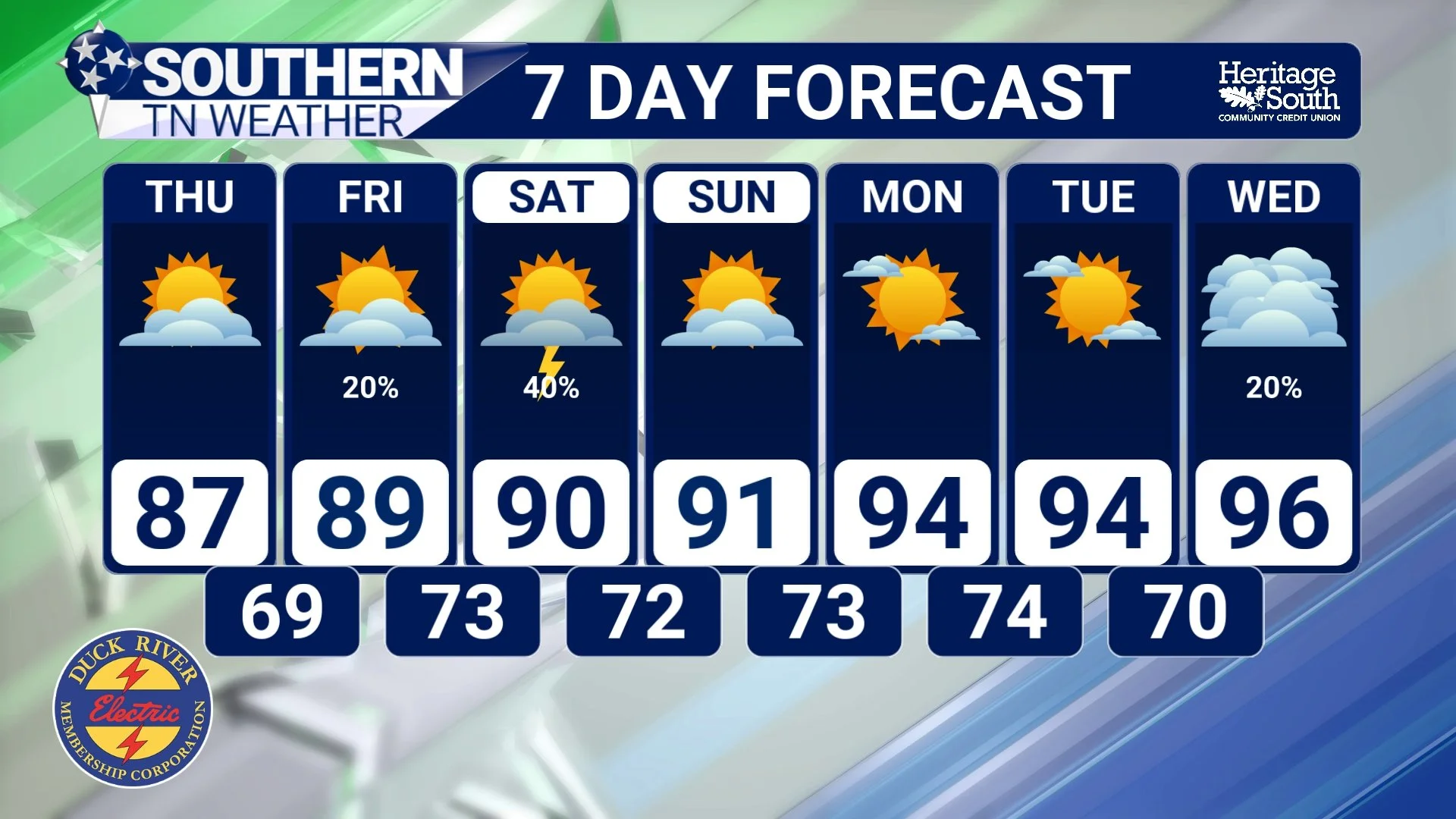
STNWX 7-DAY FORECAST
The Bottom Line 🧾
Pleasant weather continues today with highs in the low to mid 80s.
Areas of fog may develop again tonight.
Isolated showers and thunderstorms return Thursday and Friday.
Rain chances continue through the weekend.
A few stronger storms with gusty winds and heavy rainfall are possible this weekend.
Temperatures climb into the upper 80s and lower 90s by Saturday and Sunday.
Heat index values above 100° appear increasingly likely early next week.
Major heat impacts may develop Monday through Wednesday.
📰 Reminder: The Southern Tennessee Weather Blog, presented by Heritage South Community Credit Union, is updated Monday through Friday with fresh, locally tailored forecasts you can trust.