
Storm Reports from Thursday & A Look Ahead Toward Christmas

The Southern Tennessee Weather Blog is proudly presented by Heritage South Community Credit Union.
We Help When Others Won’t!
Visit https://www.heritagesouth.org/ today to see how HSCCU can help YOU!
Thursday’s cold front definitely packed a punch across Southern Middle Tennessee. While the severe weather threat going into the event was fairly low, we still ended up with numerous damage reports, mainly due to strong winds interacting with saturated ground conditions.
Let’s recap what happened Thursday, then look ahead to a much calmer and warmer stretch of weather as we approach Christmas.
Thursday Recap: Wind Was the Main Story
Thursday’s cold front largely behaved as expected, but in a few important ways it overperformed. While widespread severe thunderstorms were not anticipated, the system produced heavier rainfall than forecast along with strong wind gusts that were more than enough to cause problems. Most communities picked up between 1.0 and 1.5 inches of rainfall, which exceeded earlier projections. That rain fell efficiently during the morning and early afternoon hours, saturating soils just ahead of the strongest winds later in the day. Once the front arrived, wind gusts increased rapidly, and in a few spots, gusts reached near 60 mph within stronger storms.
That combination (wet ground and strong winds) created a perfect setup for trees to come down more easily than they otherwise would have. This is an important distinction. While atmospheric “storm fuel” remained limited, which was expected, ground conditions played a major role in the impacts we saw. Trees that might normally withstand gusts of this magnitude were much more vulnerable due to softened soils.
Many of the reports came out of Moore County, where a Severe Thunderstorm Warning was in effect as storms moved through.
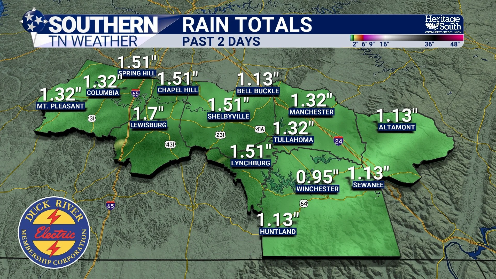
Rainfall Totals - Past 2 Days
Confirmed Storm Reports from Thursday Night
Trees down on Anderson Road, Marble Hill Road, and Lost Creek Road (Moore County)
Multiple trees down on Tanyard Hill Road and Damron Road (Moore County)
Trees blown down near County Line Road and Highway 82 (Moore County)
Reports of trees falling on vehicles and property (Spring Hill, Maury County)
A garage door blown in and fencing damaged (Chapel Hill, Marshall County)
This type of damage is consistent with a line of strong to locally severe thunderstorms, even in a setup where widespread severe weather was not expected. Of course, there are plenty of reports not listed here. These are the reports that I currently have verified, though.
Damage Reports from our area Thursday night
A Personal Note
I also want to take a moment to say thank you… This was my first severe weather event operating fully as Southern Tennessee Weather, and while I strive for excellence with every forecast, I’m always learning and refining how I serve this community. Leading up to Thursday, the data consistently pointed toward a lower-end event with strong winds as the primary concern. While that part of the forecast verified, I did underestimate the widespread nature of the wind damage, largely due to how saturated the ground became earlier in the day.
I truly appreciate the support, patience, and trust shown during the event. I was live for over an hour tracking storms, and I take this responsibility seriously. This is my business, this is my company, and I am all in on providing the most accurate and honest weather information possible.
Quiet and Cool Today, Warmer Weekend Ahead
Behind the front last night, dry high pressure has settled in, bringing sunshine and noticeably cooler temperatures today. Highs are reaching the mid 40s, with a light west breeze adding a bit of a chill. That won’t last long. As the surface high slides east, southerly winds return and temperatures rebound nicely this weekend. Saturday looks milder with highs in the 50s and gusty south winds, while Sunday will be slightly cooler but still near seasonal normals.
A weak front passes Saturday night, but guidance continues to trend drier, with little to no meaningful rainfall expected.
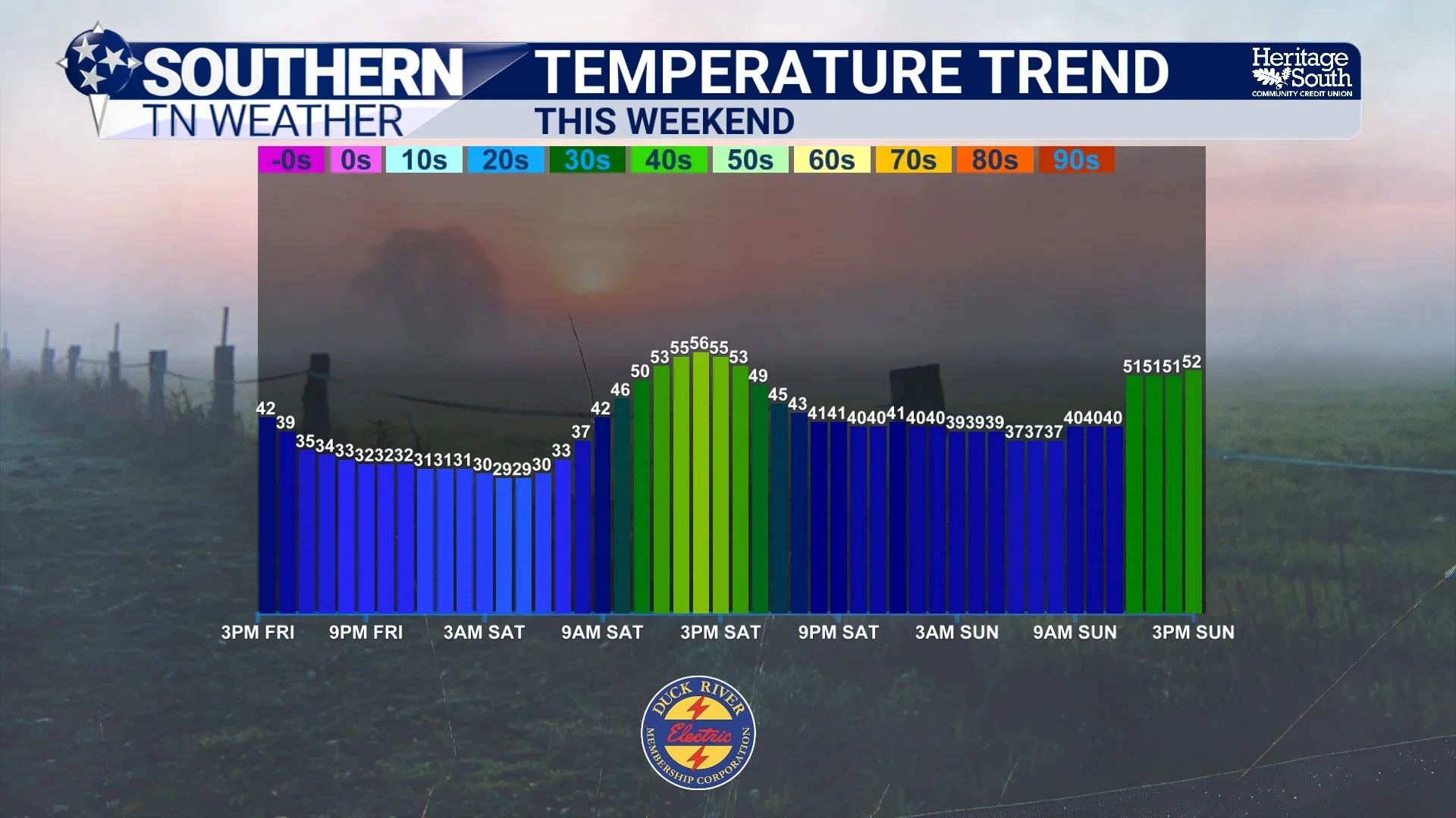
Temperature Trend - This Weekend
Next Week: Mild with Occasional Light Rain
Looking ahead to Monday and Tuesday, a passing disturbance may bring low to medium chances for light showers, but rainfall looks scattered and light with no hazardous weather expected.
After that system moves through, a ridge builds in and sets the stage for a very mild Christmas!
Christmas Forecast: Warm and Dry
Current guidance continues to support Christmas Eve and Christmas Day highs in the 60s, with a few locations possibly touching the lower 70s. Dry conditions are favored, making this one of the warmer Christmas periods we’ve seen in recent years. For reference, the record high for Christmas Day in Nashville is 76°, so while this will be well above normal, it’s not unprecedented.
Thankfully, the weather pattern is calming down nicely as we head into the holiday, and I truly appreciate each and every one of you for trusting Southern Tennessee Weather.
Climate Prediction Center Outlook for Christmas
The Bottom Line 🧾
• Thursday’s storms produced some wind damage, largely due to saturated soils and gusty winds
• Rainfall totals overperformed, with many areas receiving 1.0 to 1.5 inches
• Quiet, cooler weather settles in today behind the cold front
• Temperatures rebound into the 50s this weekend with mostly dry conditions
• Low chances for light showers Monday and Tuesday, no hazardous weather expected
• Christmas Eve and Christmas Day look warm and dry, with highs in the 60s and possibly near 70°
📰 Reminder: The Southern Tennessee Weather Blog (Presented by Heritage South Community Credit Union) is updated Monday through Friday with fresh, locally tailored forecasts you can trust.