
The Weather We Forgot Existed

The Southern Tennessee Weather Blog is proudly presented by Heritage South Community Credit Union.
We Help When Others Won’t!
Visit https://www.heritagesouth.org/ today to see how HSCCU can help YOU!
After spending much of the second half of May talking about thunderstorms, flooding concerns, humidity, and rainfall totals, today's forecast almost feels strange. Not because anything exciting is happening, but because almost nothing is happening at all. Across Southern Middle Tennessee this afternoon, temperatures have climbed into the upper 70s and lower 80s under a mix of sunshine and fair-weather clouds. A refreshing northeast breeze continues to move through the region, and for the first time in quite awhile, radar across much of Tennessee is remarkably quiet.
Honestly, it's the kind of weather that often gets overlooked. Yet these are some of the nicest days we experience all year!
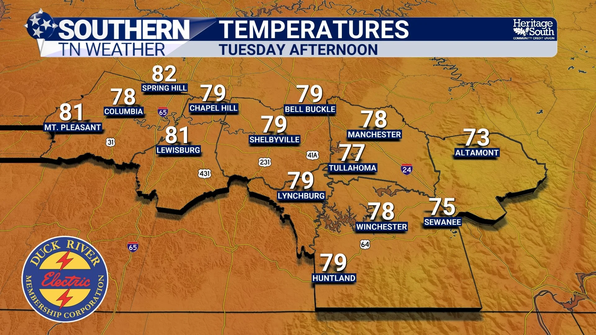
TEMPERATURES - THIS AFTERNOON
Sometimes Boring Is Beautiful
We spend a lot of time talking about storms because storms are naturally attention-grabbing. They produce dramatic radar images. They generate warnings. They create headlines. But the reality is that most people would probably choose a sunny 80-degree afternoon over a severe thunderstorm watch every single time.
That's exactly what we're experiencing right now. A large area of high pressure is gradually building into the Tennessee Valley, helping suppress cloud development and making it much more difficult for showers and thunderstorms to form. Instead of tracking storm systems, we're watching a much quieter atmosphere settle across the region. The result is several consecutive days of weather that can simply be enjoyed.
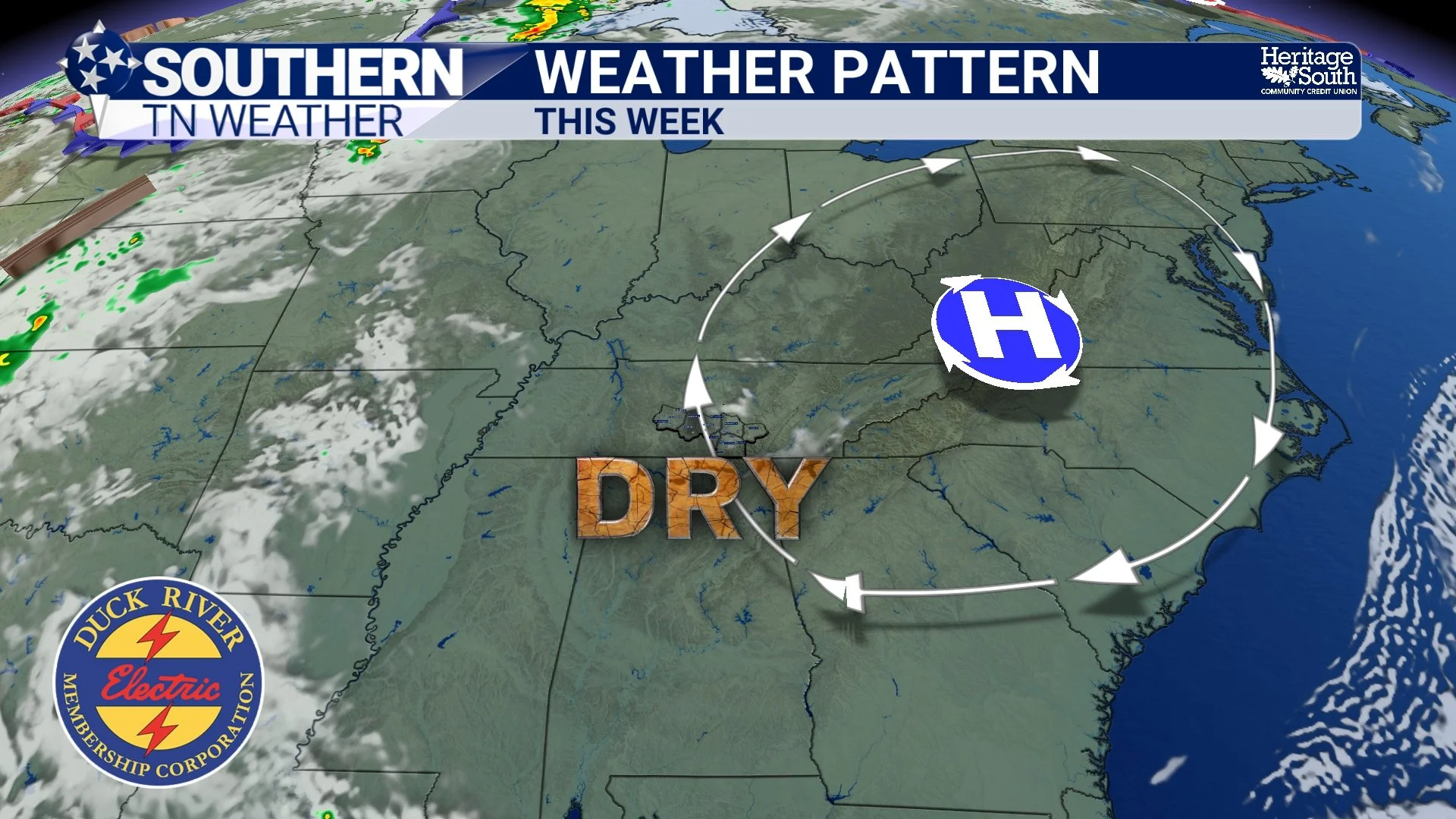
WEATHER PATTERN - THIS WEEK
The Difference Is In The Air
One of the reasons today feels so different isn't necessarily the temperature. In fact, temperatures really aren't that unusual for early June. What's different is the air itself. Over the past couple of weeks, dewpoints frequently sat in the upper 60s and lower 70s. That's the type of air that immediately feels sticky when you step outside.
Today is a different story. Drier air has filtered southward behind Monday's storm system, allowing humidity levels to drop noticeably. The result is a much more comfortable afternoon despite temperatures being fairly similar to what we've seen recently. It's a good reminder that temperature only tells part of the weather story. Sometimes a day with a high of 81° can feel dramatically different than another day with a high of 81° simply because the humidity has changed.
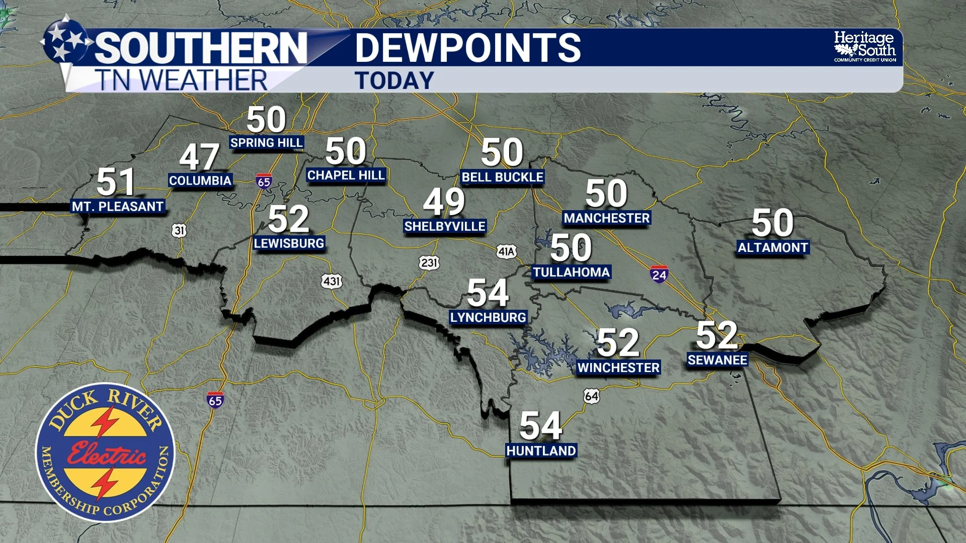
DEWPOINTS - TODAY
The Forecast Gets Repetitive For A Good Reason
Over the next several days, don't be surprised if the forecast starts sounding very similar from day to day. That's because high pressure will dominate the weather pattern through at least Friday. Wednesday, Thursday, and Friday all look remarkably similar: Plenty of sunshine, comfortable mornings, seasonable afternoons, and no meaningful rain chances.
For weather enthusiasts, that may seem boring. For everyone who has spent the past two weeks mowing around rain showers, rescheduling outdoor activities, or watching thunderstorms develop every afternoon, it's probably welcome news!
The Weekend Begins To Change The Conversation
Of course, weather patterns never stay the same forever. As we head toward the weekend, the area of high pressure responsible for our pleasant weather will gradually weaken and shift eastward. That will allow moisture from the Gulf to slowly begin working back into the region. The process looks gradual rather than dramatic. Saturday currently appears mostly dry for many locations, although an isolated shower can't be ruled out. By Sunday and early next week, scattered showers and thunderstorms will begin reappearing in the forecast.
The good news is that we're not currently seeing signs of any organized severe weather pattern developing. Instead, this looks much more like a return to typical summertime weather where isolated storms develop in a warm and increasingly humid atmosphere.
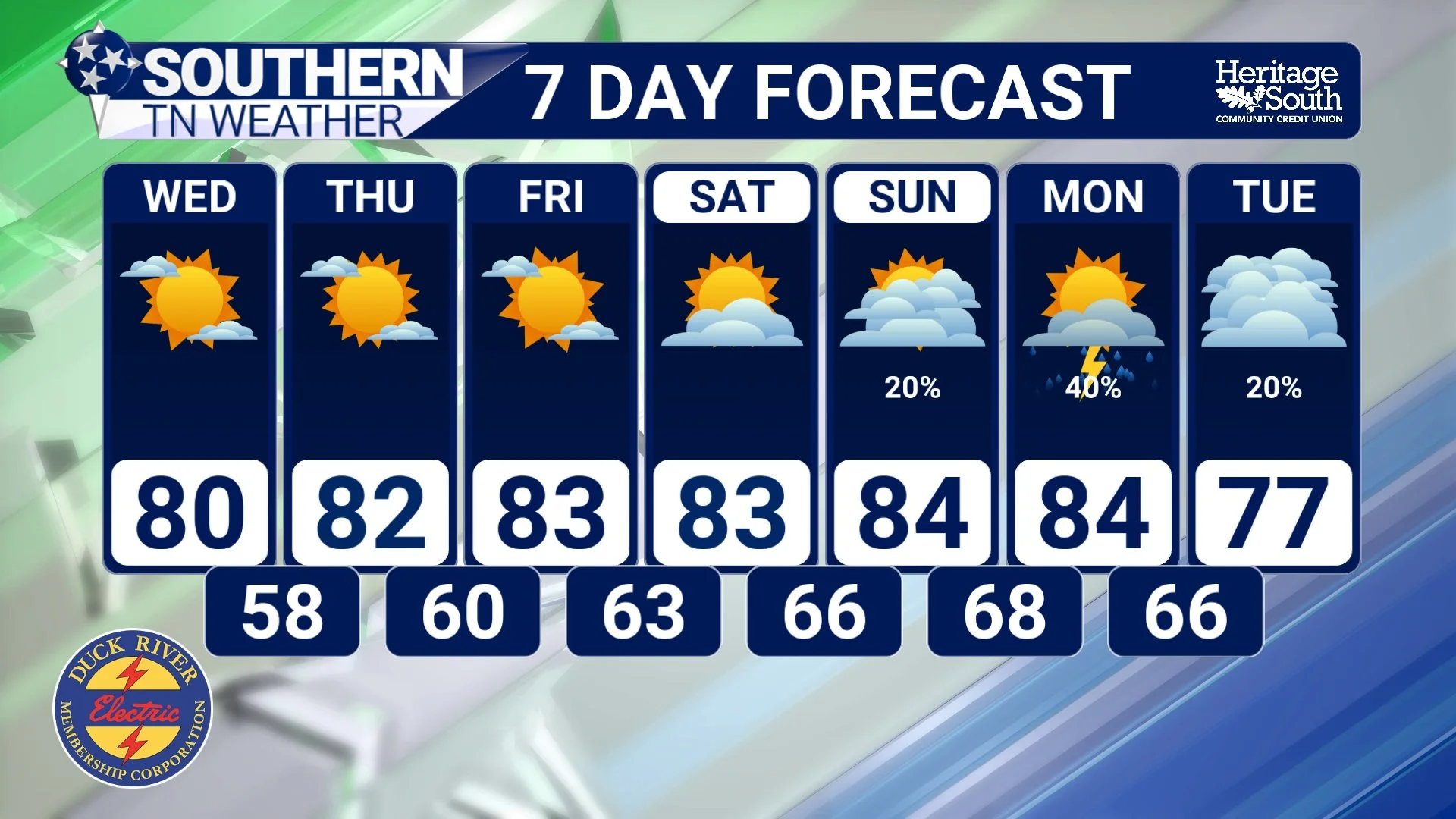
STNWX - 7 DAY FORECAST
Enjoy This Stretch While It Lasts
Forecasts like this don't usually get remembered months later. Nobody talks about "that really nice Tuesday back in June." But these are often the days that make Tennessee weather enjoyable. Open the windows in the morning. Spend some time outside after work. Take advantage of the sunshine. Because before long, we'll be talking about heat, humidity, and thunderstorms again!
The Bottom Line 🧾
Dry weather continues through Friday.
Afternoon highs remain in the upper 70s and lower 80s.
Lower humidity is making conditions feel much more comfortable.
High pressure will keep storm chances away for several days.
Temperatures gradually warm later this week.
Small rain chances return this weekend.
More typical summertime weather returns early next week.
📰 Reminder: The Southern Tennessee Weather Blog, presented by Heritage South Community Credit Union, is updated Monday through Friday with fresh, locally tailored forecasts you can trust.