
The Devil's Armpit Returns

The Southern Tennessee Weather Blog is proudly presented by Heritage South Community Credit Union.
We Help When Others Won’t!
Visit https://www.heritagesouth.org/ today to see how HSCCU can help YOU!
The weather across Southern Middle Tennessee is about to change in a big way. Today, we're still keeping an eye on a few showers and thunderstorms capable of producing heavy rainfall and gusty winds. By tomorrow, however, the conversation shifts dramatically as hotter temperatures and sticky humidity take over the forecast.
In other words… The Devil's Armpit is making a comeback.
After several days of active weather and localized flooding concerns, we're transitioning toward a much more typical June weather pattern. The atmosphere isn't completely finished with rain just yet, but by the middle of the week, heat will become the bigger story.
One Last Round Of Storms
While the widespread flooding concerns we've dealt with over the past few days have eased, we're not completely done with unsettled weather. A mesoscale convective vortex, or MCV, will move through Middle Tennessee this afternoon and evening. These leftover circulations from previous thunderstorm complexes can often provide just enough lift to spark another round of showers and storms.
The atmosphere remains very unstable thanks to daytime heating and plenty of available moisture. Wind shear isn't particularly impressive, but it doesn't need to be. A few storms could become strong enough to produce gusty winds during the afternoon and evening hours.
Localized flash flooding also remains possible. The Flood Watch has been cancelled because widespread flooding is no longer expected, but any thunderstorm that develops will still be capable of producing very heavy rainfall over a short period of time. Most of the activity should diminish by late this evening.
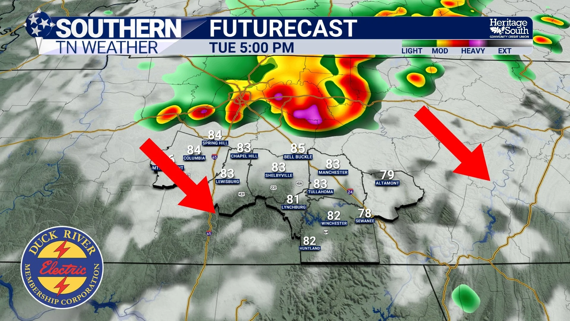
FUTURECAST - THIS EVENING
Trading Rain For Heat
Once today's storms move out, the overall weather pattern begins shifting. High pressure will gradually expand into the area from the west, reducing rain chances and allowing temperatures to climb through the middle of the week. This doesn't mean we're entering a completely dry pattern. In fact, isolated afternoon thunderstorms will remain possible. But compared to the repeated rounds of widespread showers and storms we've dealt with recently, coverage will become much more limited.
The tradeoff for fewer storms is hotter weather. Wednesday will feature highs in the upper 80s and lower 90s across much of Southern Middle Tennessee. By Thursday, many locations should reach the low 90s, making it the hottest day of the week.
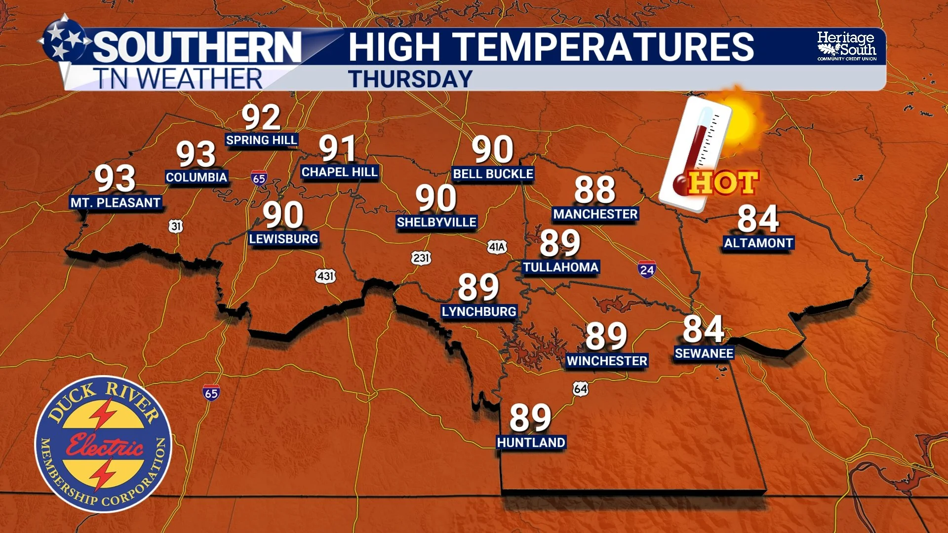
HIGH TEMPERATURES - THURSDAY
Why It'll Feel So Hot
The temperature itself is only part of the story. Humidity levels will remain elevated as Gulf moisture stays firmly in place across the region. Dewpoints in the 70s combined with afternoon temperatures in the 90s will push heat index values into the upper 90s and lower 100s, especially west of the Cumberland Plateau. For many of us, this will be our first real taste of prolonged summer heat.
The first hot stretch of the season often catches people off guard. After weeks of talking about severe weather, flooding, and cooler mornings, our bodies haven't fully adjusted to spending long periods in hot and humid conditions. If you'll be spending time outdoors Wednesday and Thursday, make sure to stay hydrated, wear lightweight clothing, and take breaks whenever possible. Check on neighbors and family members who may be more sensitive to the heat, and never leave children or pets unattended inside vehicles.
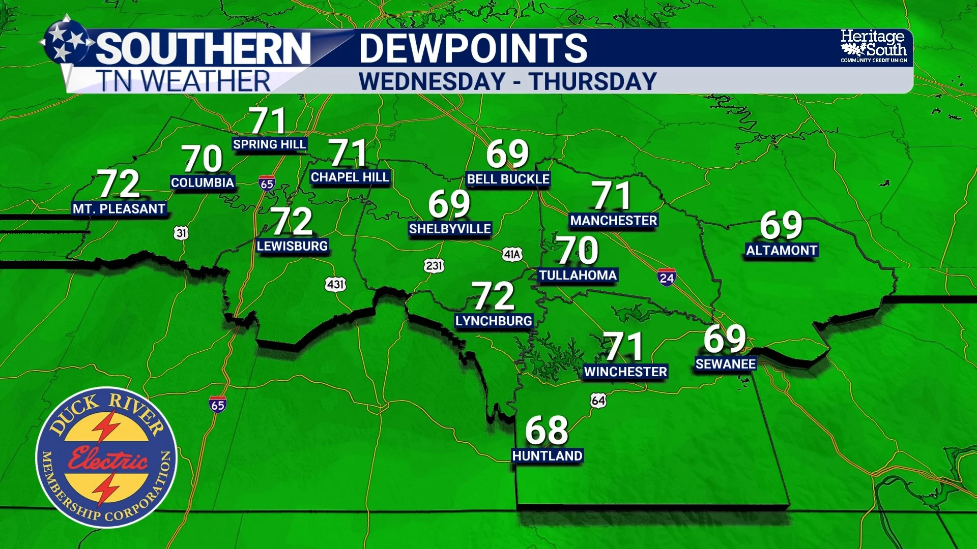
DEWPOINTS - WEDNESDAY THRU THURSDAY
RAIN WILL RETURN QUICKLY
The heat won't have complete control for long. Another cold front is expected to approach the area on Friday, bringing a better chance for showers and thunderstorms back to Southern Middle Tennessee. At this point, I'm not seeing an obvious signal for organized severe weather, although a few stronger storms can't be ruled out given the amount of daytime heating and instability available.
Beyond Friday, forecast confidence decreases somewhat, but the overall pattern favors continued warm and humid conditions with periodic chances for showers and thunderstorms through the weekend and into early next week. Some longer-range guidance even hints at a larger system developing over the Great Lakes next week that could help knock temperatures back into the lower and middle 80s. It's too early to lock that in, but it's certainly something I'll be keeping an eye on.
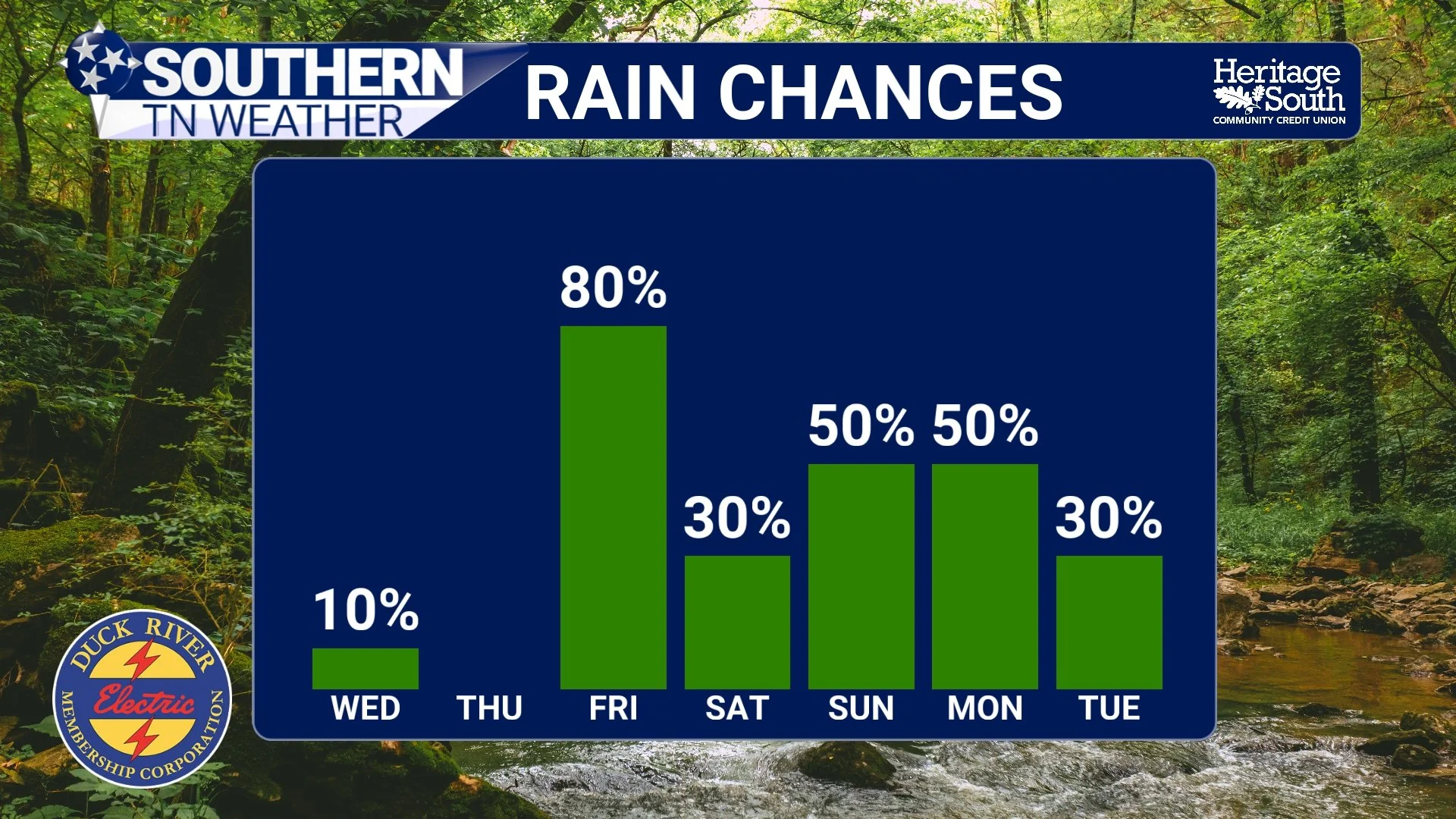
RAIN CHANCES - NEXT 7 DAYS
After a wet start to June, summer is finally beginning to settle in. And yes… The Devil's Armpit is back.
The Bottom Line 🧾
A few showers and thunderstorms remain possible through tonight.
A couple of storms could produce strong wind gusts
Localized flash flooding remains possible, but widespread flooding concerns have decreased.
Temperatures climb into the upper 80s and lower 90s Wednesday.
Thursday looks to be the hottest day of the week with highs in the mid 90s.
Heat index values around 100° are likely Wednesday and Thursday.
Better shower and thunderstorm chances return Friday with an approaching cold front.
A more typical Tennessee summer pattern is taking over.
📰 Reminder: The Southern Tennessee Weather Blog, presented by Heritage South Community Credit Union, is updated Monday through Friday with fresh, locally tailored forecasts you can trust.