
From Heavy Rain To Heat: Tennessee's Weather Is Changing Gears

The Southern Tennessee Weather Blog is proudly presented by Heritage South Community Credit Union.
We Help When Others Won’t!
Visit https://www.heritagesouth.org/ today to see how HSCCU can help YOU!
It's going to be a busy week across Southern Middle Tennessee, but perhaps not for the reasons you might expect. Over the next several days, we'll be dealing with a little bit of everything. Showers and thunderstorms will continue through at least Tuesday with localized flooding concerns, while by the middle of the week our attention will gradually shift toward building heat and humidity as summer begins tightening its grip on the region.
In many ways, this week serves as a transition between two different weather patterns.
The Rain Isn't Finished Yet
An active weather pattern remains in place across Middle Tennessee today and Tuesday, with periodic rounds of showers and thunderstorms expected to develop. The good news is that I'm not overly concerned about widespread severe weather. While an isolated strong storm capable of producing gusty winds can't be ruled out, the overall severe threat remains low.
Instead, the bigger concern continues to be heavy rainfall. The atmosphere over Tennessee is loaded with moisture, with precipitable water values exceeding two inches. That's an impressive amount of moisture for early June and means any thunderstorm that develops will have plenty of fuel to produce torrential downpours. At the same time, winds higher in the atmosphere remain fairly weak. That allows storms to move slowly or repeatedly track across the same locations, increasing the risk for localized flash flooding. A FLOOD WATCH is in effect for our entire area through Tuesday afternoon. Yes, it was just extended. Why? Because the NWS is concerned about very isolated areas seeing extreme rainfall accumulations.
Not everyone will experience flooding problems early this week. In fact, many locations may simply receive beneficial rainfall. However, a few communities could see several rounds of storms while neighboring towns receive much less. That's the nature of summertime convection across Tennessee.
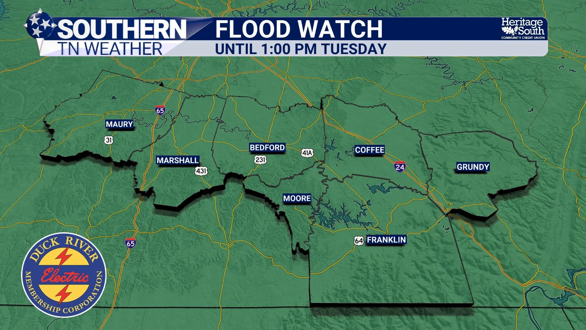
FLOOD WATCH
The Pattern Begins To Shift
By Wednesday, the atmosphere starts changing. A stronger subtropical ridge will gradually build across the southern United States, and while it won't completely eliminate rain chances, it will reduce the overall coverage of thunderstorms. We'll likely transition away from widespread clusters of rain toward the more familiar scattered afternoon and evening storms that develop during the hottest part of the day.
But that pattern change comes with a tradeoff. As rain coverage decreases, sunshine becomes more common, allowing temperatures to climb steadily through the remainder of the week.
The Heat Starts Becoming The Story
By Wednesday and especially Thursday and Friday, temperatures should reach the lower and middle 90s across much of Southern Middle Tennessee. Ordinarily, that wouldn't be too unusual for June. The bigger factor will be the humidity.
Dewpoints are expected to remain in the 70s, and when you combine that moisture with afternoon temperatures in the 90s, heat index values could approach 100 degrees by the middle of the week. It's also worth remembering that we haven't had many prolonged stretches of hot weather yet this year. Our bodies are still adjusting to the changing seasons, which can make the first significant heat events feel particularly uncomfortable.
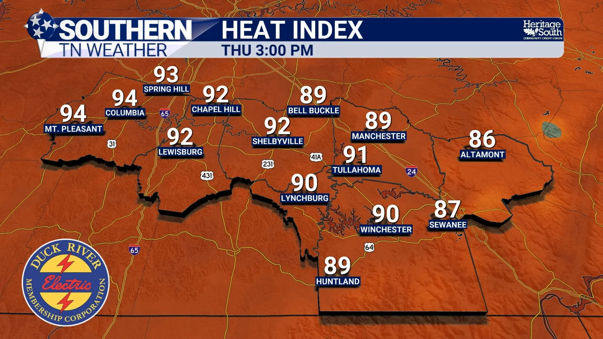
HEAT INDEX - THURSDAY PM
Looking Ahead
For now, the focus remains on showers and thunderstorms through Tuesday with localized flooding concerns continuing to be the primary hazard. As we move deeper into the week, rain coverage should gradually decrease while temperatures and humidity continue increasing. Afternoon thunderstorms won't disappear completely, but they'll become more ISOLATED and typical of what we'd expect during a Tennessee summer.
By the end of the week, many of us will be trading flood watches for heat index values approaching 100 degrees. That's June in Tennessee for you.
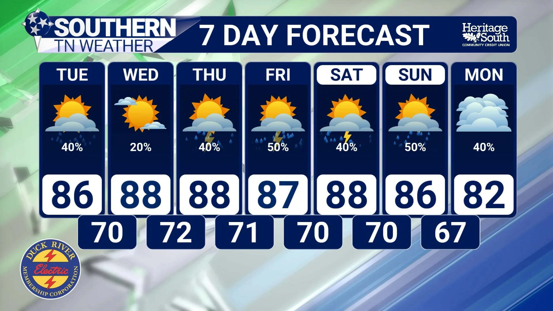
STNWX 7-DAY FORECAST
The Bottom Line 🧾
Showers and thunderstorms continue through Tuesday.
Localized flash flooding remains the primary concern.
Severe weather chances stay low.
Storm coverage gradually decreases later this week.
Temperatures climb into the lower and middle 90s.
Heat index values could approach 100 degrees by midweek.
Typical summertime afternoon thunderstorms persist.
The weather story shifts from heavy rain to heat and humidity as the week progresses.
📰 Reminder: The Southern Tennessee Weather Blog, presented by Heritage South Community Credit Union, is updated Monday through Friday with fresh, locally tailored forecasts you can trust.