
Hot, Humid, Then Stormy

The Southern Tennessee Weather Blog is proudly presented by Heritage South Community Credit Union.
We Help When Others Won’t!
Visit https://www.heritagesouth.org/ today to see how HSCCU can help YOU!
If you've stepped outside today, you've probably noticed two things. First, it's hot. Second, it's humid.
And while that may not sound particularly unusual for June in Tennessee, the weather pattern setting up over the next several days is actually laying the groundwork for our next chance of more widespread showers and thunderstorms. The good news is that today and tomorrow should be relatively quiet. The bad news? Mother Nature is simply taking a breather before another pattern change arrives on Friday.
High Pressure Is Running The Show
The main weather feature influencing Southern Middle Tennessee right now is an upper-level ridge of high pressure stretching across much of the southeastern United States. When meteorologists talk about a "ridge," we're referring to an area where the atmosphere is essentially sinking rather than rising. Sinking air tends to suppress cloud development and thunderstorm activity, which is why rain chances remain very low through Thursday.
That doesn't necessarily guarantee bright blue skies all day long. In fact, a rogue popup shower or thunderstorm can't be completely ruled out, especially near the Cumberland Plateau where the terrain itself can help spark convection. For most of us though, today and Thursday will simply be hot, humid, and largely dry.

TEMPERATURES - THIS AFTERNOON
Why It Feels So Sticky
One interesting aspect of this week's forecast is that our humidity isn't coming solely from the Gulf of Mexico. The recent rounds of heavy rainfall across Middle Tennessee have left many soils saturated. As the sun heats the ground, moisture evaporates back into the atmosphere, adding to the already humid air mass in place. We call this evapotranspiration, a combination of evaporation from the ground and water released by vegetation. The result is an atmosphere that feels even more uncomfortable than the thermometer alone might suggest.
Afternoon temperatures today and Thursday should climb into the lower and middle 90s across much of Southern Middle Tennessee. Combined with dewpoints in the lower 70s, it'll feel more like 100 degrees during the hottest part of the afternoon. If you'll be working or spending time outdoors, make sure you're staying hydrated and taking frequent breaks.
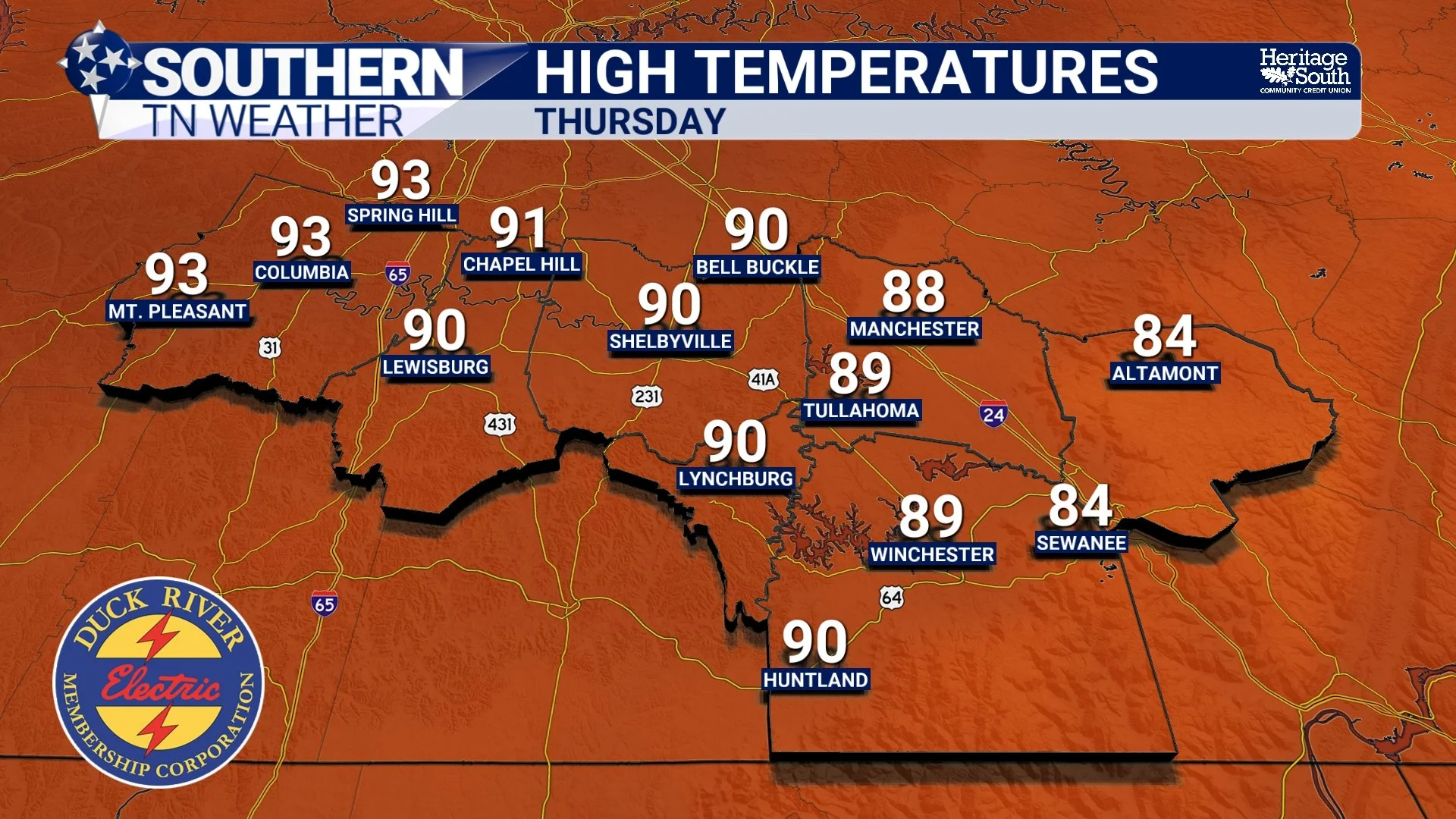
HIGH TEMPERATURES - THURSDAY
Friday Changes Things
While high pressure dominates our weather now, it won't last forever. A cold front approaching from the northwest will become the focus for shower and thunderstorm development on Friday. At this point, the front appears to arrive during the afternoon and evening hours, which is important because that's when the atmosphere is typically at its most unstable thanks to daytime heating.
There are still some uncertainties regarding exactly how widespread storm coverage becomes and how much the front weakens as it approaches Tennessee. However, the overall setup favors numerous showers and thunderstorms developing along and ahead of the boundary. Some storms could become strong, with damaging wind gusts appearing to be the primary concern at this time. Of course, with humidity remaining high and plenty of moisture available, heavy rainfall will also accompany many of the storms. It's not shaping up to be a major severe weather outbreak, but Friday is certainly a day I'll be watching closely.
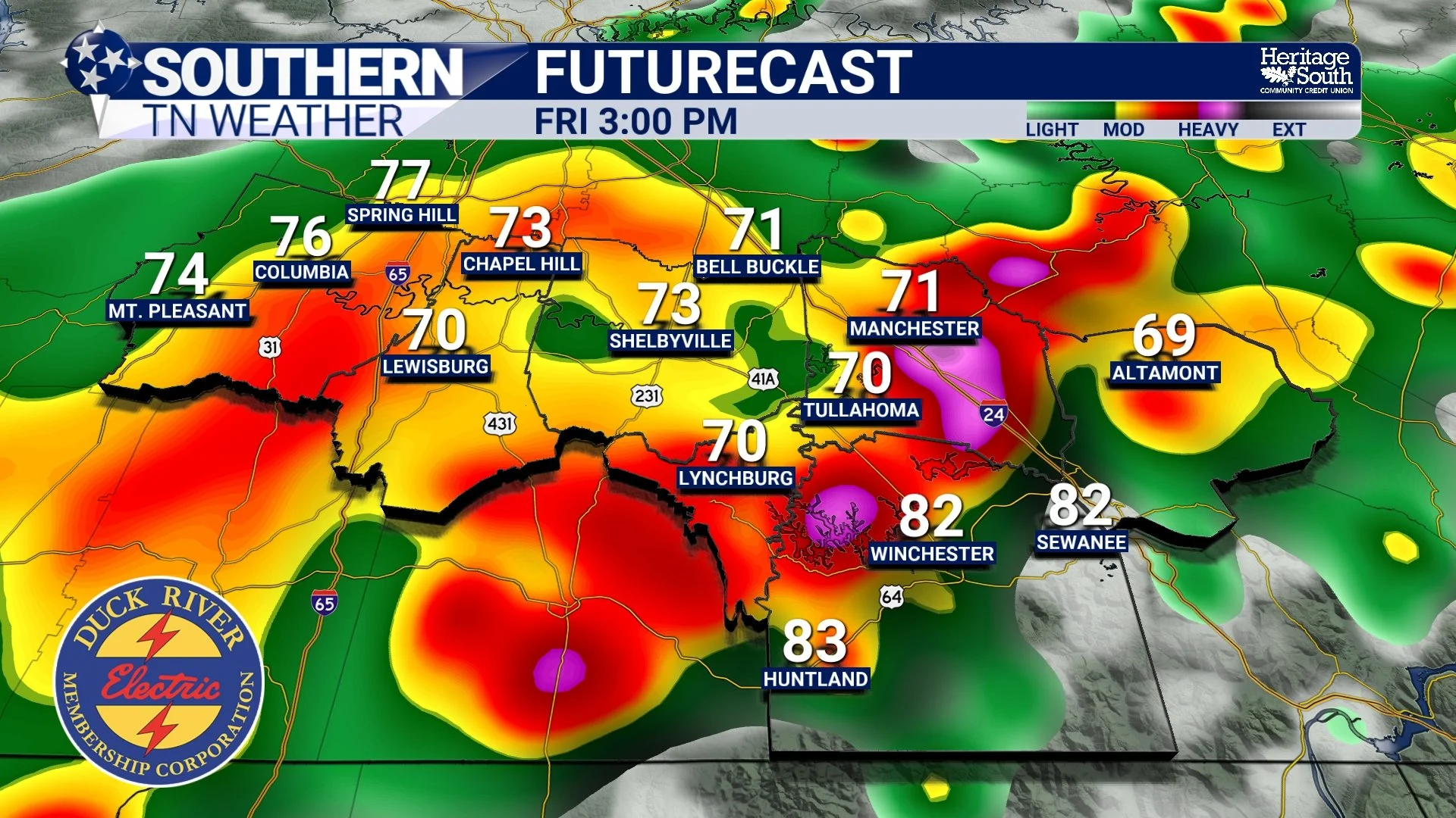
FUTURECAST - FRIDAY
The Weekend Doesn't Completely Dry Out
Once the front moves through Friday night, we'll likely catch a bit of a break on Saturday with somewhat more stable conditions. Unfortunately, that break probably won't last very long.
Humidity remains firmly in place across the southeastern United States, and additional disturbances moving through the upper-level flow should bring renewed chances for showers and thunderstorms by Sunday and into early next week. Forecast confidence decreases beyond Saturday, but the overall pattern favors periodic opportunities for rain rather than a prolonged dry stretch.
Looking Ahead
This week's forecast is a good reminder that summer weather isn't always about one extreme or another. Today and Thursday are dominated by heat and humidity under high pressure. Friday brings another opportunity for showers and thunderstorms as a cold front arrives. Then the weekend transitions back toward a more unsettled pattern. It's a classic June setup across Tennessee. The quiet weather we're enjoying now isn't the end of the story. It's simply the calm before the front.
The Bottom Line 🧾
Hot and humid weather continues today and Thursday.
Heat index values around 100° are expected across much of Southern Middle Tennessee.
Rain chances remain very low through Thursday.
A cold front brings widespread shower and thunderstorm chances Friday.
A few Friday storms could become strong with damaging wind gusts.
Saturday currently looks quieter.
Shower and thunderstorm chances increase again Sunday into early next week.
Summer heat and humidity are here to stay for the foreseeable future.
📰 Reminder: The Southern Tennessee Weather Blog, presented by Heritage South Community Credit Union, is updated Monday through Friday with fresh, locally tailored forecasts you can trust.