
Temperatures Moderate as Rain Moves Back Into the Area

The Southern Tennessee Weather Blog is proudly presented by Heritage South Community Credit Union.
We Help When Others Won’t!
Visit https://www.heritagesouth.org/ today to see how HSCCU can help YOU!
Southern Middle Tennessee is finally beginning to ease out of the harsh Arctic pattern that dominated much of late January, but winter is not finished with us just yet. While the most extreme cold has retreated for now, the overall pattern remains active enough to bring a round of widespread rain on Tuesday, followed by another cool-down midweek and a continuation of cold mornings paired with milder afternoons.
Today: Quiet Weather and a Modest Warm-Up
A shortwave ridge is building overhead today, allowing skies to clear and winds to remain light. After a cold start this morning, temperatures are responding to sunshine and climbing into the upper 40s across much of Southern Middle Tennessee, with a few lower 50s possible in our southern and western communities.
This ridge represents only a brief pause in the active pattern. High-level clouds will increase this evening as the next system approaches from the west. Overnight lows will fall into the upper 20s to lower 30s, depending on cloud cover and location, but this will feel noticeably milder compared to recent nights.
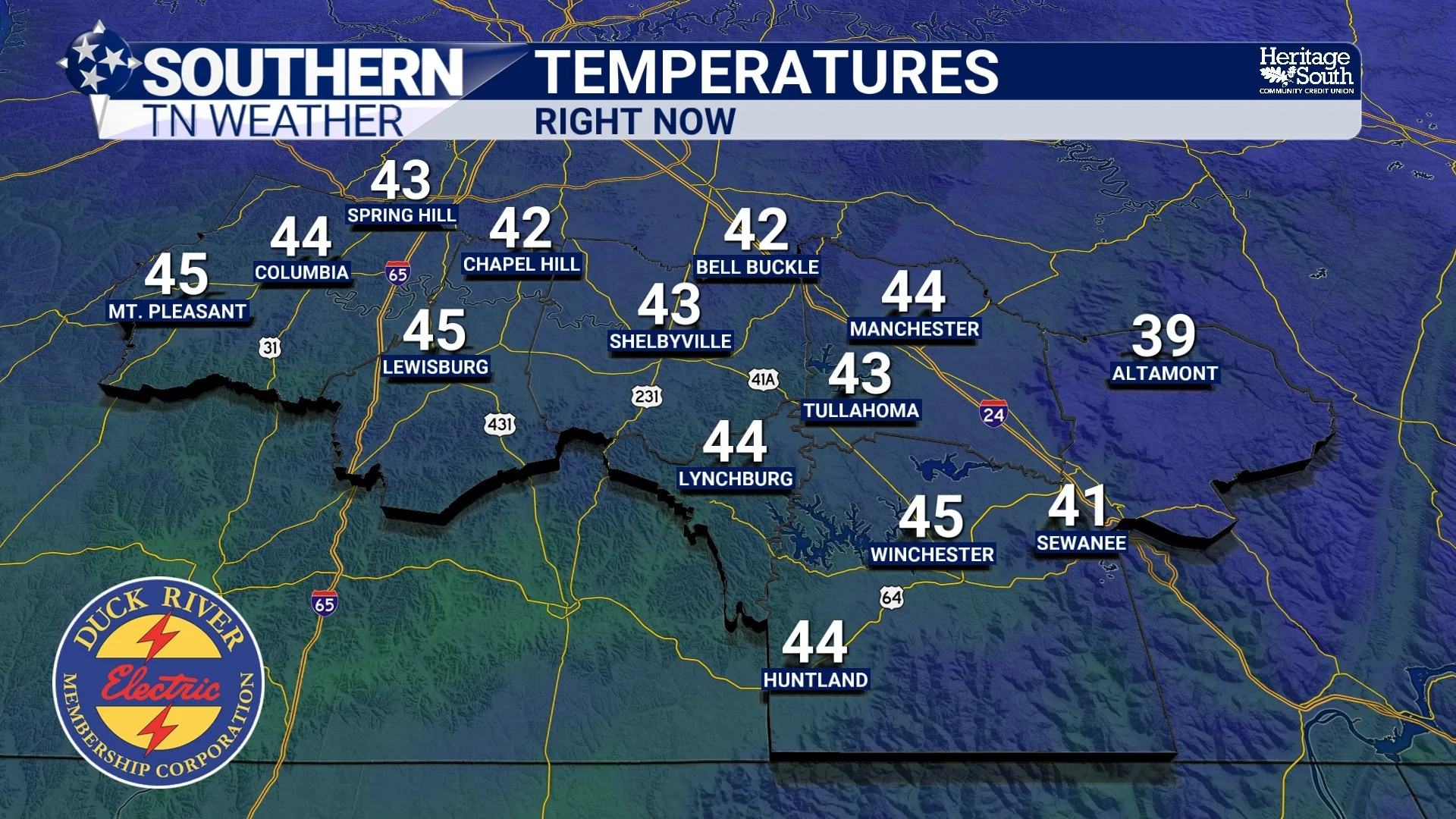
Temperatures - Right Now
Tuesday: Widespread Rain, No Winter Weather Concerns
Tuesday will be the most impactful day of the forecast, though impacts should be beneficial rather than hazardous. A shortwave trough will dig southeast out of the northern Plains, inducing surface low development over Tennessee by Tuesday afternoon. Southerly flow ahead of this system will draw moisture northward, allowing rain to develop by mid-morning in western portions of Southern Middle Tennessee and spread eastward through the afternoon. Local timing right now looks to be between noon and 9 PM. Despite the clouds and rain, temperatures will remain warm enough to support all liquid precipitation. Forecast soundings clearly show the colder air lagging well behind the precipitation shield, so there is no concern for snow or ice with this system.
Rainfall totals are expected to vary across the region, with lighter amounts (0.25 to 0.5 inches) toward the northwest and heavier totals (0.5 to 0.75 inches) toward the southeast. This rainfall is actually welcome, as it helps chip away at a longer-term dry stretch that developed prior to the recent winter storms. Showers will taper from west to east Tuesday evening as a cold front moves through. Winds will turn northwest behind the front, but the colder air arrives after precipitation has ended.
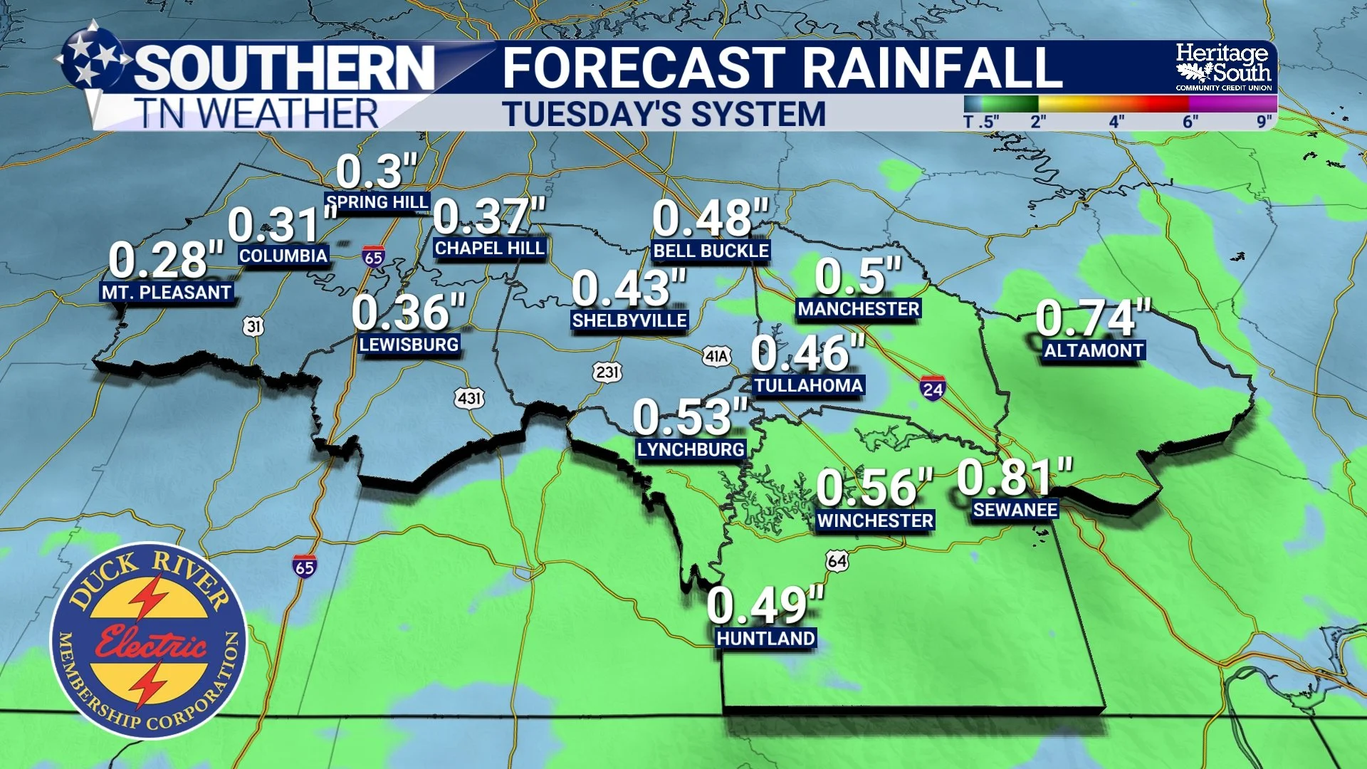
Forecast Rainfall - Tuesday’s System
Midweek: Cooler Temperatures and Winterlike Nights
Colder air filters back into Southern Middle Tennessee on Wednesday. Highs will drop into the upper 30s to lower 40s, with a noticeable chill in the northwest breeze. By Wednesday night, high pressure building in from the west, which will set the stage for another cold night, with lows falling into the teens across much of the area. This is well below normal for early February. I’m not completely ruling out a few passing flurries Wednesday night into early Thursday as the parent trough digs southward, but moisture is very limited. At this time, no accumulations or impacts are expected.
Thursday remains dry and cool, with highs again in the upper 30s to lower 40s. Clear nights and dry air will allow temperatures to dip below freezing each morning through the end of the week.
Late Week Into the Weekend: Temperature Swings, Quiet Pattern
Heading into the end of the week and the upcoming weekend, the pattern becomes more zonal but remains active enough to prevent a sustained warm-up. Upper-level ridging builds eastward late week, allowing highs to rebound into the lower to mid-50s on Friday. Another trough passing well to our northeast late Friday into Saturday will knock temperatures back into the 40s, but moisture with that system remains north and east of Southern Middle Tennessee. Dry weather continues.
High pressure quickly reasserts itself behind that trough, allowing temperatures to recover into the 50s again by Sunday and early next week. A few locations may even flirt with the lower 60s as we move into next week.
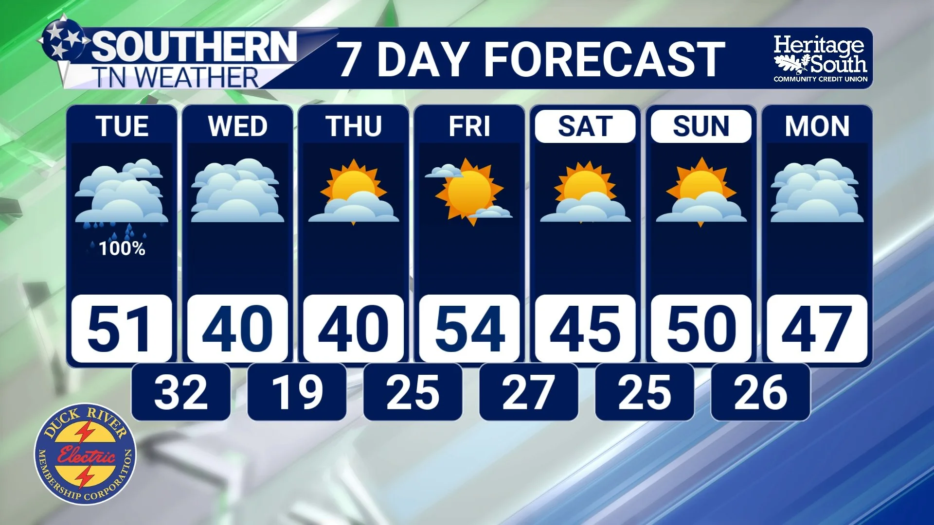
7-Day Forecast
The Bottom Line 🧾
• Temperatures warm today and Tuesday
• Widespread rain arrives Tuesday into Tuesday evening
• All precipitation remains rain with little to no winter weather concerns
• Cooler air returns midweek with highs in the 30s and 40s
• Overnight lows dip into the teens Wednesday night
• Dry weather dominates the second half of the week
• Temperatures rebound into the 50s again by late week and next weekend
📰 Reminder: The Southern Tennessee Weather Blog, presented by Heritage South Community Credit Union, is updated Monday through Friday with fresh, locally tailored forecasts you can trust.