
Snow Showers and Dangerous Cold: What to Expect Across Southern Middle Tennessee this Weekend

The Southern Tennessee Weather Blog is proudly presented by Heritage South Community Credit Union.
We Help When Others Won’t!
Visit https://www.heritagesouth.org/ today to see how HSCCU can help YOU!
Southern Middle Tennessee is now firmly entering the heart of an Arctic outbreak, and while light snow showers and flurries will remain part of the forecast through Saturday, they are not the primary concern. This is not shaping up to be a high-impact snowfall event for our region. Instead, the dominant and most dangerous hazard through the weekend will be the intensity and duration of the cold air settling in behind the snow.
This is a pattern where impacts are driven less by accumulation totals and more by exposure risk, wind chill, and how long temperatures remain below freezing.
The Big Picture: Why Snow Is Light but Cold Is Severe
A deep upper-level trough continues to dig southward out of the Great Lakes today, with an impressive closed upper low forecast to pass directly over Middle Tennessee early Saturday. Dynamically, this is a strong system — but it is moisture-starved on its western flank, which places Southern Middle Tennessee in a zone favorable for scattered snow showers rather than widespread accumulating snow. What makes this setup noteworthy is not the precipitation, but the air mass moving in behind it.
Forecast guidance shows 850-mb temperatures plunging to near –20°C by Saturday morning. The 850-mb level represents roughly 4,500–5,000 feet above sea level and is one of the most reliable ways to evaluate the true strength of an air mass. When temperatures at this level drop that low, it tells us several important things:
The cold air is deep, not shallow
Daytime warming will be extremely limited, even with sunshine
Any precipitation that occurs will fall entirely as snow
Surface temperatures will struggle to recover once they fall below freezing
For Southern Middle Tennessee, –20°C at 850 mb is an exceptionally cold value, more typical of the Upper Midwest than the Southeast. This confirms that the cold we’re dealing with is not fleeting — it is entrenched and difficult to modify. As Arctic high pressure builds south behind the system, the pressure gradient tightens, resulting in persistent northerly winds. Those winds will significantly enhance heat loss and drive wind chill values toward (and at times below) zero.
Today Through Tonight: Snow Showers Expand, Arctic Air Arrives Quickly
Light snow showers are already ongoing across parts of the region this afternoon as a convergence boundary pushes south through Middle Tennessee. Coverage will remain scattered, but any location that briefly finds itself under a more persistent snow shower could see a light dusting. As we move into this evening and overnight hours, snow showers will become more focused toward areas east of Interstate 65 and across the Cumberland Plateau, where lift is stronger and moisture is slightly deeper. These snow showers will be uneven and hit-or-miss, meaning totals will vary significantly over short distances.
While snow will get attention, the more important development tonight is the rapid arrival of Arctic air. Even with cloud cover limiting radiational cooling, temperatures will fall sharply overnight. By daybreak Saturday, most of Southern Middle Tennessee will be in the single digits to teens. With northerly winds sustained around 10–15 mph, wind chill values will drop near or just below zero, especially late tonight and early Saturday morning.
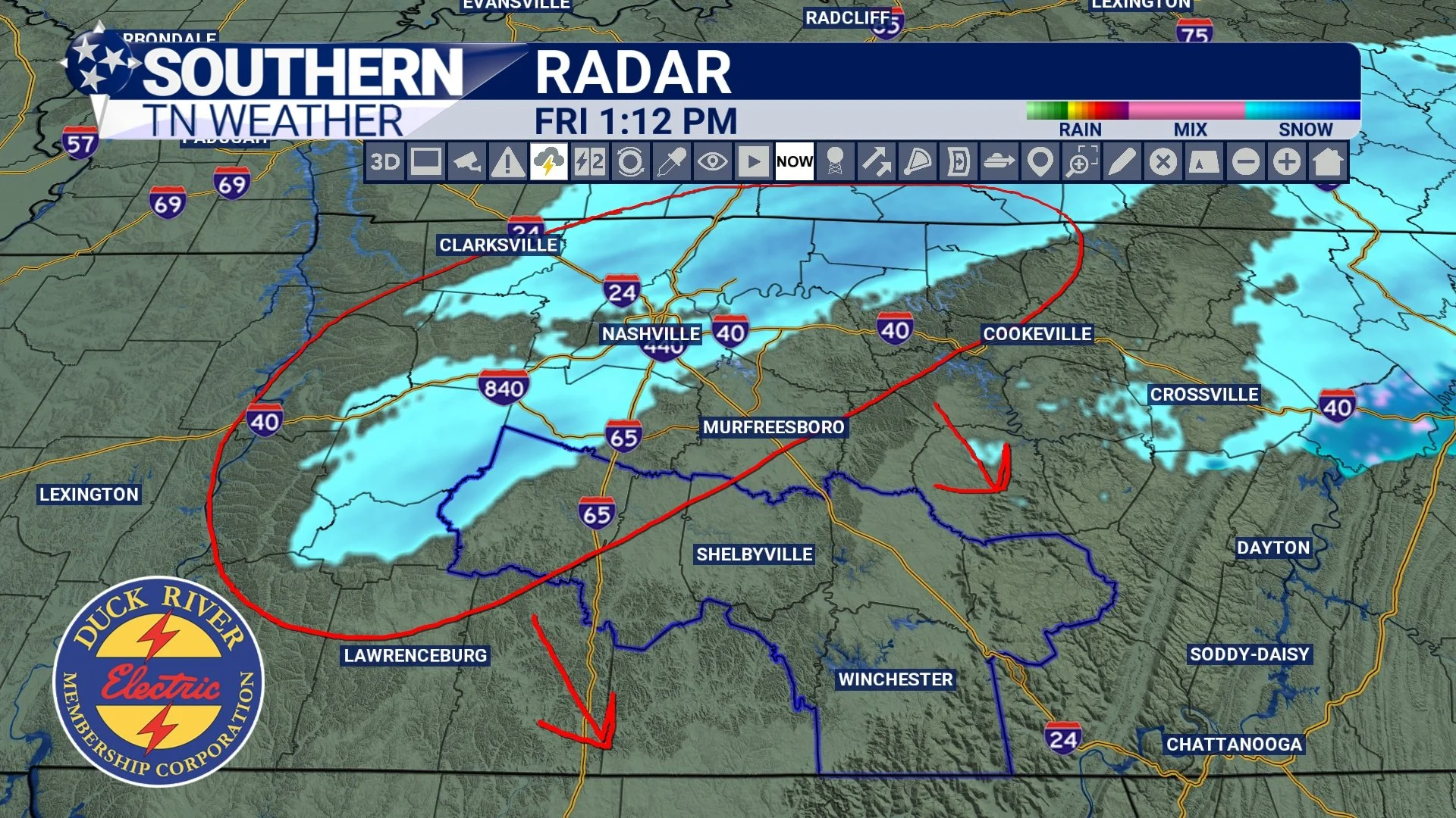
Current Radar - Friday Afternoon
Saturday: Snow Showers Linger, Cold Becomes the Primary Hazard
Saturday morning marks the passage of the upper-level low directly through the region. This will keep flurries and light snow showers going, particularly along the Plateau where lingering lift and upslope effects persist the longest. Snowfall expectations remain modest:
Most of Southern Middle Tennessee: a dusting to perhaps a half inch
Cumberland Plateau: 30–50% chance of up to one inch, with most locations closer to a half inch
Snowfall rates will be light, and travel impacts from snow alone should remain minor. However, temperatures will be far too cold for melting. Any snow that falls will stick to untreated surfaces, especially secondary roads and elevated areas. High temperatures Saturday will struggle to reach the upper teens to lower 20s, and with winds continuing, wind chill values will remain in the single digits throughout the day.
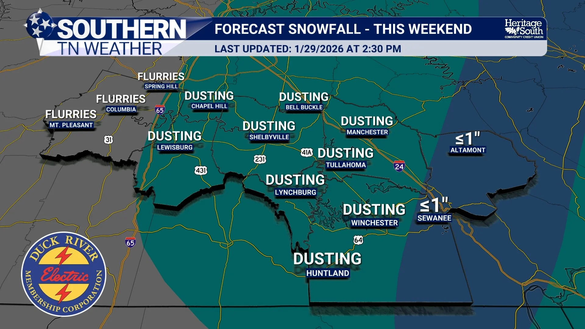
Snowfall Forecast - This Weekend
Saturday Night into Sunday: The Cold Tightens Its Grip
Saturday night into Sunday morning is shaping up to be the coldest stretch of this event. Arctic high pressure settles more firmly overhead, and while some cloud cover may linger, lows are still expected to drop into the single digits and low teens. If skies clear more than currently expected, a few locations could dip even lower. Wind chills Saturday night and early Sunday will once again hover near or below zero, though winds will gradually ease later Sunday. Even with some sunshine returning Sunday afternoon, temperatures will only recover into the mid-20s to lower 30s.
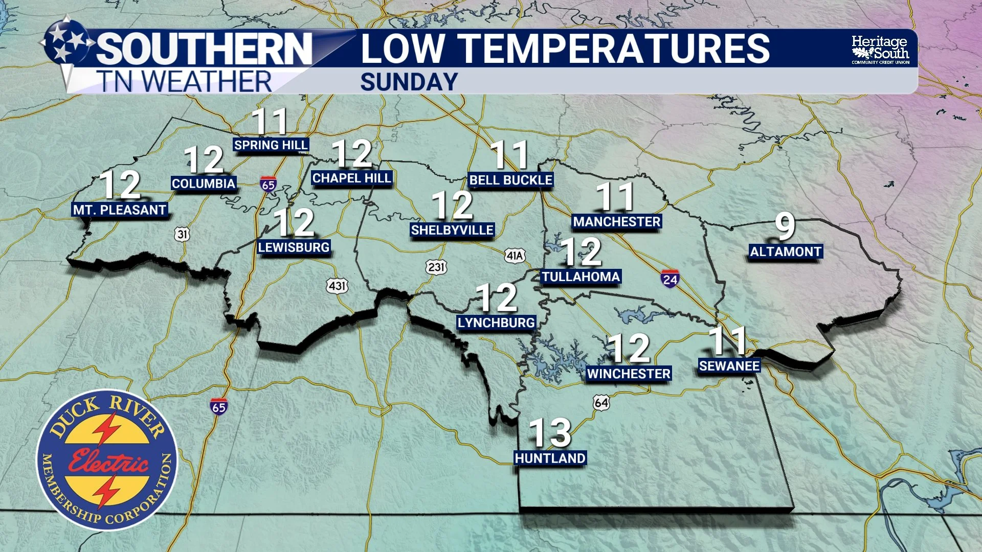
Low Temperatures - Sunday Morning
Why This Cold Is Dangerous
This is not just a brief cold snap. It is a prolonged Arctic blast, which significantly increases the risk of:
Hypothermia and frostbite with extended outdoor exposure
Frozen pipes and infrastructure issues
Persistent black ice on roads, bridges, and overpasses
Stress on pets, livestock, and vulnerable populations
Because of this, a Cold Weather Advisory remains in effect, and conditions will repeatedly approach dangerous thresholds through the weekend — especially during nighttime and early morning hours.
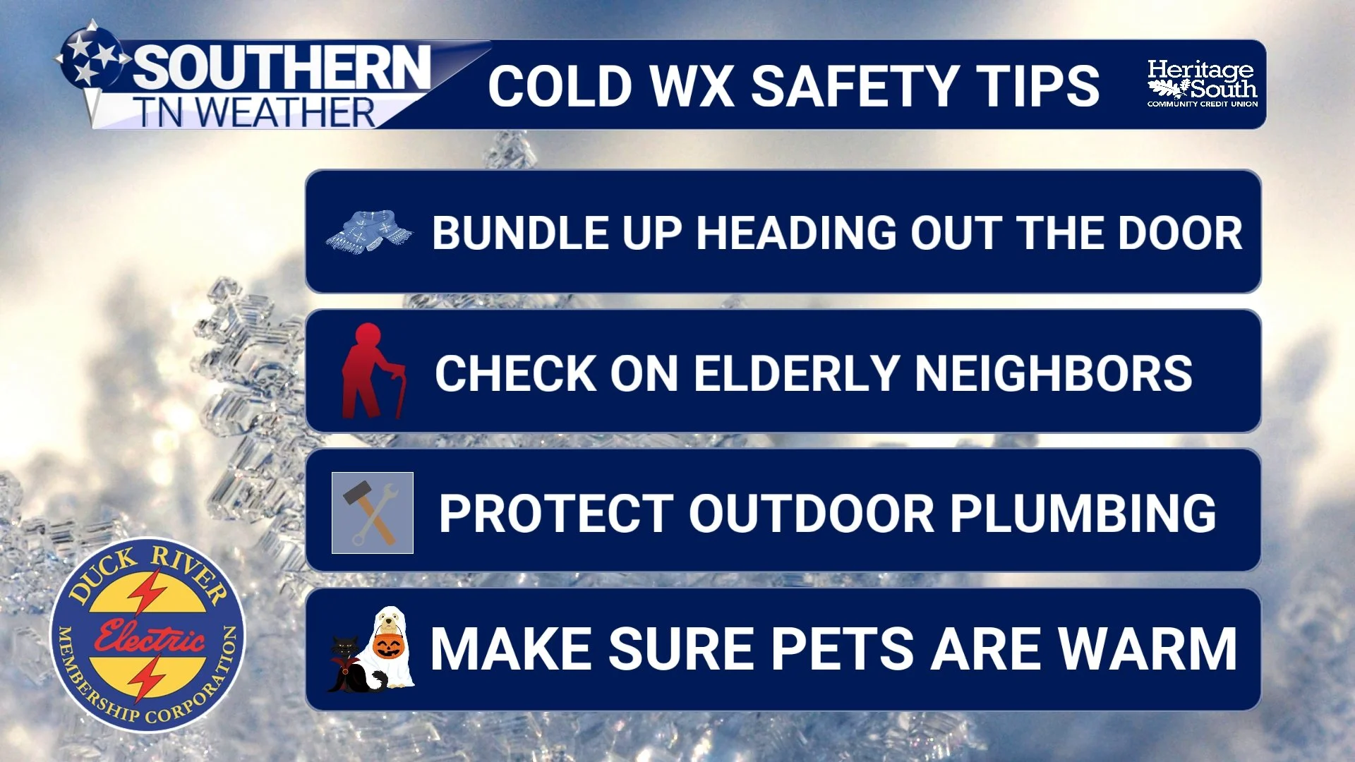
Could WX Safety Tips
Looking Ahead: A Gradual Thaw Next Week
The pattern finally begins to relax early next week. Highs climb back into the 40s on Monday and into the 50s by Tuesday, with rain chances returning midweek. That combination should finally allow for meaningful melting of remaining snow and ice. Another cold front later next week may cool things back down, but first we have to get through this weekend.
The Bottom Line 🧾
Light snow showers and flurries continue through Saturday
Most areas see a dusting to ½", up to ~1" possible on the Plateau
Snow impacts are minor, but any snow will stick
Arctic air is the dominant hazard this weekend
Single-digit lows expected, especially Saturday and Sunday mornings
Wind chills near or below zero at times
Temperatures remain below freezing for an extended period
A gradual warm-up begins early next week
📰 Reminder: The Southern Tennessee Weather Blog (Presented by Heritage South Community Credit Union) is updated Monday through Friday with fresh, locally tailored forecasts you can trust