
Strong to Severe Storms Possible Sunday into Monday

The Southern Tennessee Weather Blog is proudly presented by Heritage South Community Credit Union.
We Help When Others Won’t!
Visit https://www.heritagesouth.org/ today to see how HSCCU can help YOU!
Even though we have some beautiful weather to get through tomorrow, attention is now turning to late Sunday into early Monday, when a powerful storm system and strong cold front will move across the region. This system has the potential to bring strong to severe thunderstorms to Southern Middle Tennessee, with damaging winds appearing to be the primary concern. The Storm Prediction Center has placed our area under an ENHANCED risk (level 3/5) for severe thunderstorms.
While there are still some uncertainties with this setup, confidence is increasing that storms Sunday night could pack a punch.
Quiet and Warm Before the Storms
The next day and a half will feature very nice weather across the region. Temperatures will continue warming through Saturday with abundant sunshine and highs climbing into the 70s. By Sunday, however, the atmosphere will begin changing quickly as a deep storm system develops across the central United States and lifts toward the Great Lakes.
As this happens, strong southerly winds will increase across Tennessee, pulling moisture northward from the Gulf of Mexico. The pressure gradient ahead of the approaching cold front will likely become tight enough that a Wind Advisory may be needed Sunday, even before storms arrive.
Storms Likely Sunday Night
A strong cold front will push into Middle Tennessee late Sunday evening and overnight, bringing a line of showers and thunderstorms across the region. The timing right now looks to be late Sunday evening through the overnight hours into early Monday morning for Southern Middle Tennessee. Unlike many severe weather setups in the spring, this system will arrive after dark, which means atmospheric instability will be somewhat limited. However, what this setup lacks in instability, it makes up for with extremely strong wind fields in the atmosphere.
Forecast models show a powerful low-level jet of 70–80 mph just above the surface, along with a 100+ mph jet stream overhead. When winds this strong exist just above the surface, thunderstorms can tap into that energy and mix it downward. Because of this, damaging wind gusts of 60–70 mph (or higher) will be the primary severe weather threat. Exact timing still needs to be figured out, but this does look like an OVERNIGHT EVENT!
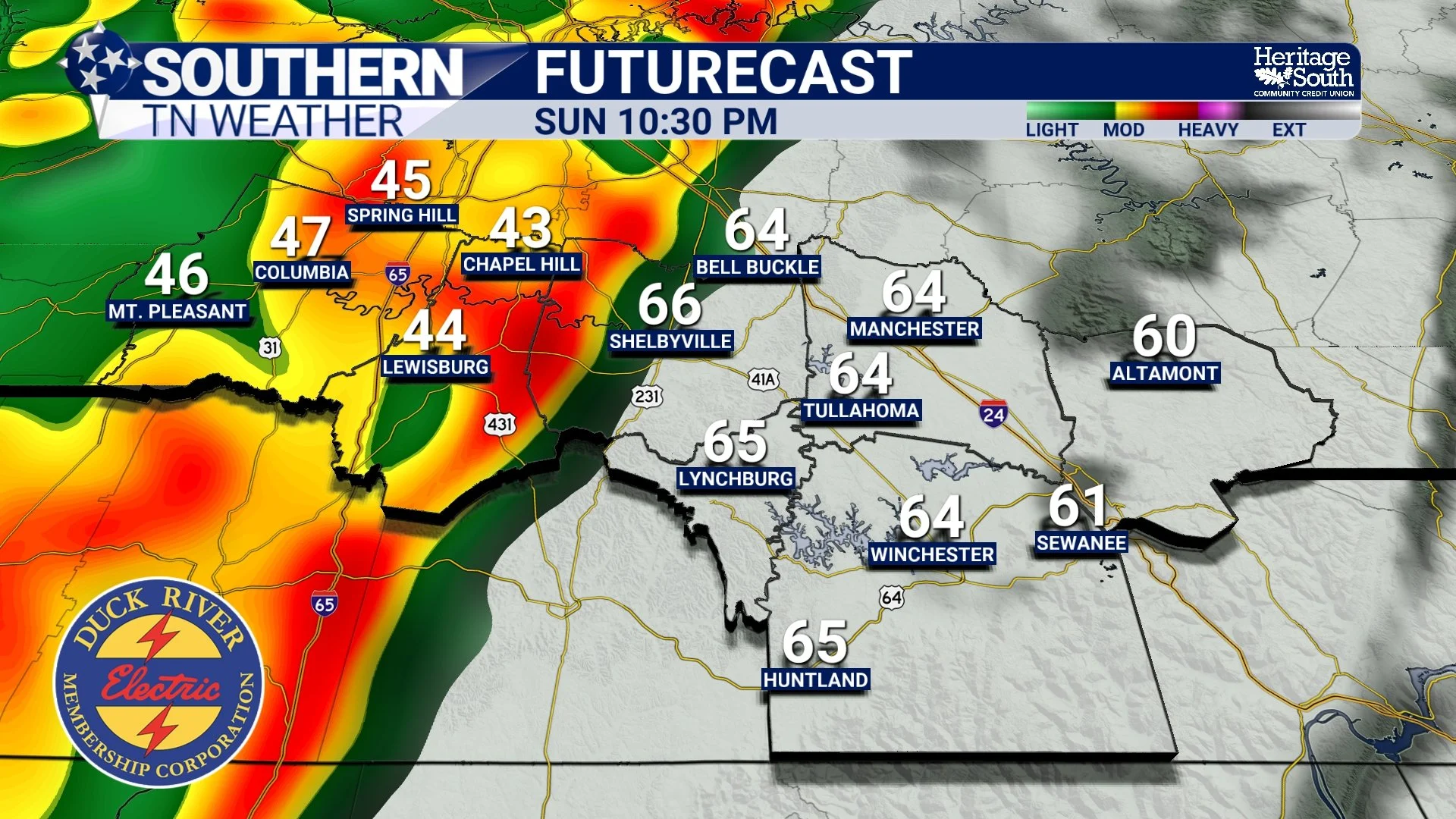
FUTURECAST - SUNDAY NIGHT
Tornado Threat Appears Low, But Not Zero
With strong wind shear in place, there will also be some tornado potential, though the overall risk currently appears low. The main reason for this is the overnight timing of the storms, which tends to limit how unstable the atmosphere becomes. Current model guidance suggests instability values may only reach around 200–300 J/kg, which is fairly modest.
However, the atmosphere will still feature very strong rotation in the lower levels, which means embedded tornadoes within the line of storms cannot be ruled out. These types of storms are often referred to as QLCS events, where a squall line produces pockets of damaging winds along with occasional brief tornadoes.
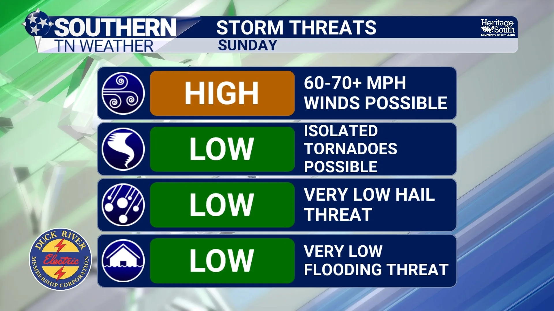
STORM THREATS - SUNDAY
Wind Could Be a Problem Even Outside of Storms
Another factor with this system will be very strong winds even before the storms arrive. Ahead of the cold front, the pressure gradient will tighten significantly, leading to very gusty south winds during the day Sunday. Wind gusts could become strong enough to meet Wind Advisory criteria in some areas.
When storms arrive later Sunday night, those strong winds aloft could easily mix down to the surface, leading to the potential for a significant high wind event in some locations. I don’t use this term lightly.
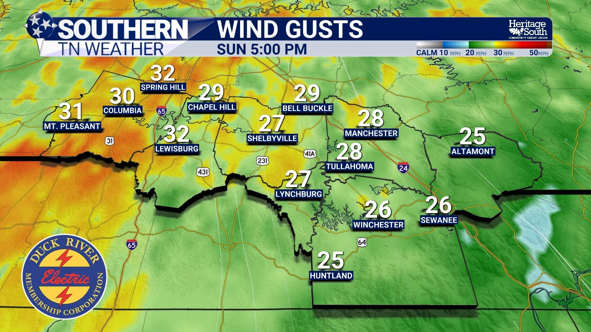
WIND GUSTS - SUNDAY AFTERNOON
Dramatic Temperature Crash After the Front
Once the cold front passes early Monday morning, the weather will change quickly. Temperatures will plummet through the day Monday, with readings struggling to reach the 40s despite it being mid-March. In fact, temperatures Sunday afternoon in the 70s will drop into the 30s by Monday morning, representing a 50-degree temperature swing in less than 24 hours.
As the colder air pours into the region, a few snow flurries may even mix in late Sunday night into Monday, though little to no accumulation is expected. Maybe a quick dusting at best for a few of us.
Hard Freeze Early Next Week
The coldest temperatures of this pattern will likely arrive Monday night into Tuesday morning. Clear skies and dry air will allow temperatures to drop into the upper teens to lower 20s across Southern Middle Tennessee, resulting in a hard freeze.
Anyone with early spring plants or sensitive vegetation should prepare to protect them!
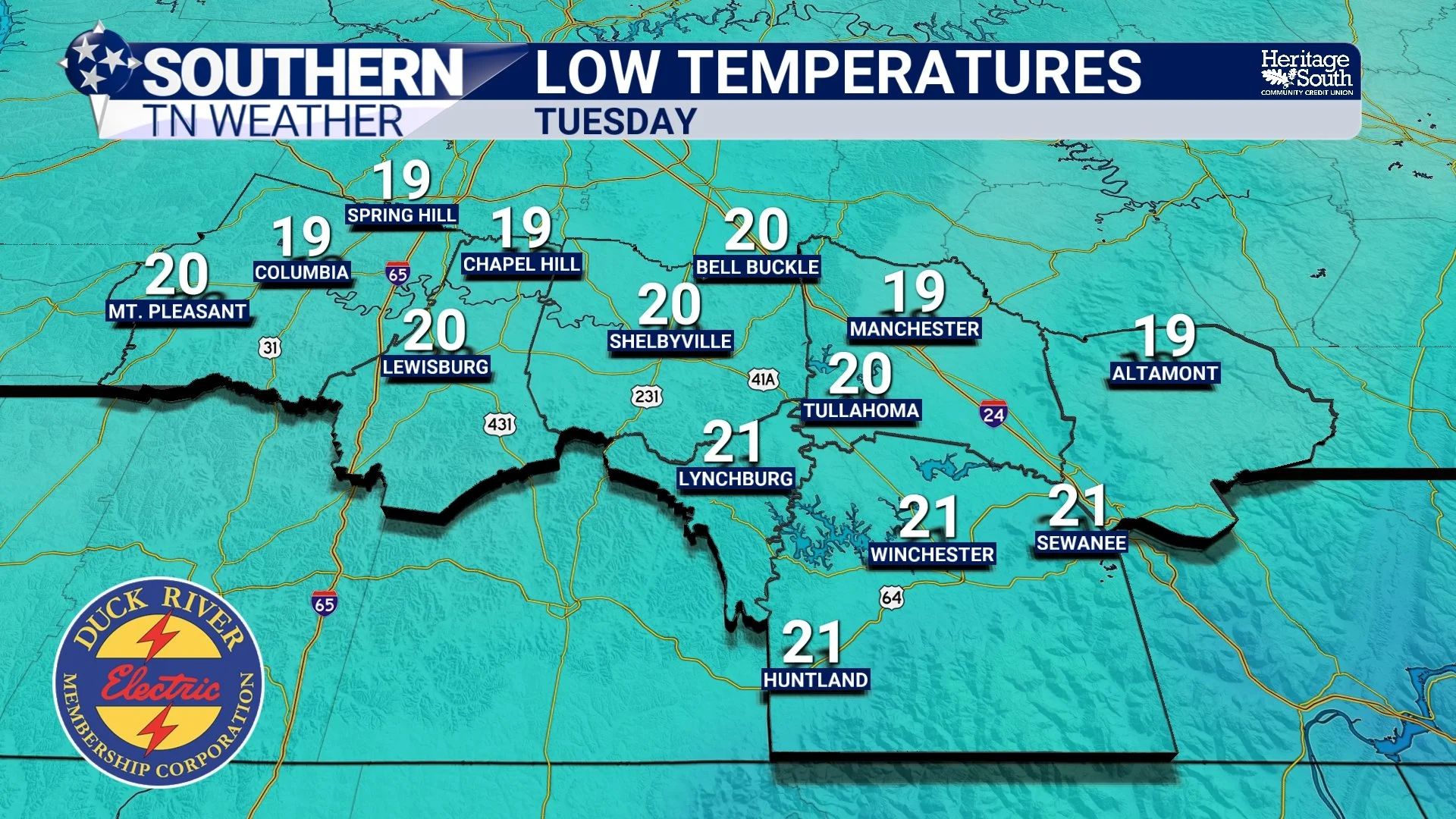
LOW TEMPS - TUESDAY MORNING
The Bottom Line 🧾
• Warm and quiet weather continues through Saturday
• Very windy conditions likely Sunday
• Strong to severe thunderstorms possible late Sunday night into early Monday
• Damaging winds of 60–70 mph are the primary threat
• Temperatures crash Monday, with highs only in the 40s
• Snow flurries possible late Sunday night or Monday
• Hard freeze likely Monday night into Tuesday morning
STAY TUNED for updates throughout the weekend on social media! NOW IS THE TIME to get your severe weather safety plan in place.
📰 Reminder: The Southern Tennessee Weather Blog, presented by Heritage South Community Credit Union, is updated Monday through Friday with fresh, locally tailored forecasts you can trust.