
Storms possible this evening: latest details here

The Southern Tennessee Weather Blog is proudly presented by Heritage South Community Credit Union.
We Help When Others Won’t!
Visit https://www.heritagesouth.org/ today to see how HSCCU can help YOU!
Round one is in the books, we've had a few hours to recharge the atmosphere, and now our attention turns to what develops through the rest of the afternoon and evening.
The complex of showers and thunderstorms that moved through parts of Southern Middle Tennessee this morning has moved out, and skies have been clearing from west to east behind it. That sunshine is important. Temperatures are rebounding, the air remains plenty humid, and leftover boundaries from this morning's storms are hanging around the region. Those boundaries can act like little "sparks" for new thunderstorm development once the atmosphere becomes unstable enough again.
That doesn't mean everybody is going to get another storm. This afternoon's activity should be scattered, so there will likely be communities that get hammered with a thunderstorm while others a county or two away stay completely dry. But the ingredients are there for additional development, and any storm that gets going will have an environment capable of supporting some stronger wind gusts.
Where Is the Greatest Severe Weather Threat?
The severe weather outlook is a little different depending on where you live in our eight-county coverage area. The Storm Prediction Center has placed most of Southern Middle Tennessee in a MARGINAL RISK (Level 1 of 5) for severe thunderstorms this afternoon and evening. However, the SLIGHT risk (level 2/5) has creeped into our area, especially Lincoln, Moore, and Franklin County.
In our coverage area, that means the greatest concern generally favors our southern counties closer to the Alabama state line, while a lower-end severe threat extends farther north. Regardless of which color you're under on the outlook map, the overall message is pretty similar: a few storms could become strong to severe, but we're not expecting everyone to see severe weather. The main concern will be damaging straight-line wind gusts, especially from storms capable of producing strong downbursts. Hail is also possible with the stronger storms, although the hail threat appears secondary to the wind threat. With plenty of moisture in the atmosphere, storms will also be capable of producing torrential rainfall and frequent lightning.
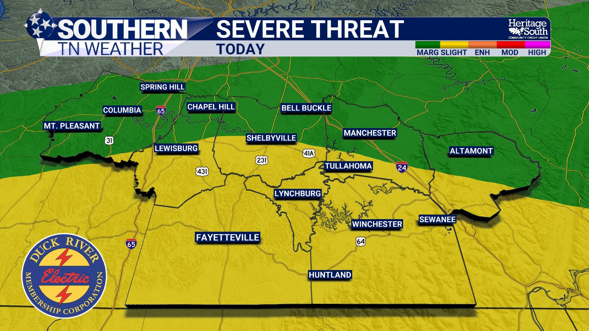
SEVERE THREAT - TODAY
What's Helping Storms Develop?
There are a few things working together this afternoon. First, the atmosphere has had time to recover behind the morning activity. Sunshine breaking through the clouds is helping temperatures climb again, which increases instability. Second, boundaries left behind by this morning's storms are still draped across portions of the region. Think of these almost like miniature fronts. Air converges along them, gets pushed upward, and sometimes that's all a humid and unstable August atmosphere needs to get a thunderstorm started.
Finally, an upper-level disturbance approaching from Missouri will provide a little extra lift as we move through the afternoon and evening. None of these ingredients by themselves scream "major severe weather event," but together they're enough to support scattered thunderstorms, including a few that could briefly become severe.
Main Timeframe: Through About 11 PM
We're already watching for development as of this 2:50 PM update, and additional showers and thunderstorms should become more common through the late afternoon and early evening. The main window we're watching is now through roughly 9:00 PM. Storms should generally move toward the southeast, although leftover outflow boundaries can make individual storm movement a little messy at times. That means a storm could develop in an area that looked perfectly fine on radar 30 or 45 minutes earlier.
Once we get past sunset, the atmosphere will begin losing the instability provided by daytime heating. A few showers or storms could linger later into the evening, but the severe weather threat should decrease considerably around or after 9 PM. If you have outdoor plans this evening (especially practices, games or other events) keep an eye on radar. Even a storm that never becomes severe can produce dangerous lightning. If you can hear thunder, you're close enough to be struck by lightning, so head indoors and wait for the storm to pass.
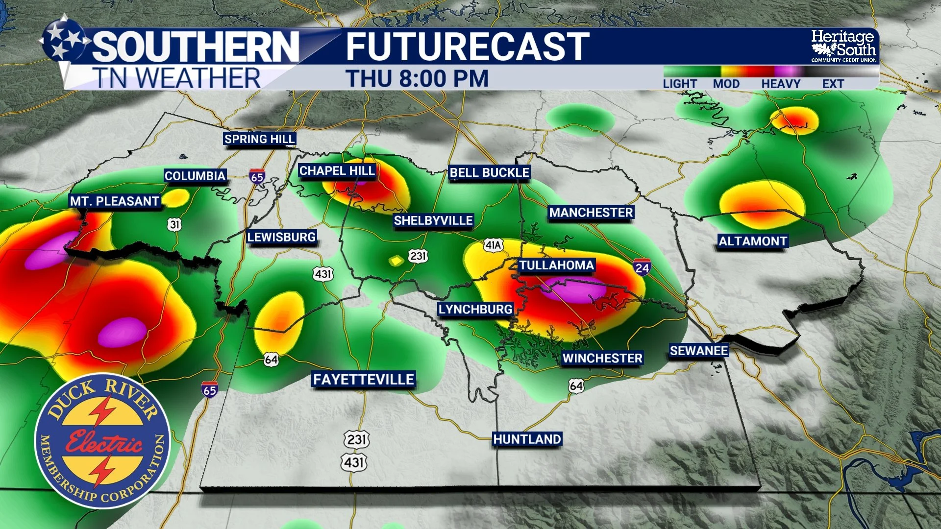
HRRR FUTURECAST
Heavy Rain Could Be a Problem in a Few Spots
One thing we've seen repeatedly this summer is just how much water these thunderstorms can dump in a short amount of time, and today is no exception. Atmospheric moisture remains very high, meaning any thunderstorm that develops will be an efficient rainfall producer. Most locations won't experience flooding, but a slow-moving or particularly intense storm could dump enough rain to cause ponding on roads or localized flash flooding. This will be especially important in communities that already picked up a decent amount of rain this morning.
As always, don't try to drive through a flooded roadway. It's impossible to know how deep the water is—or whether the road is even still underneath it.
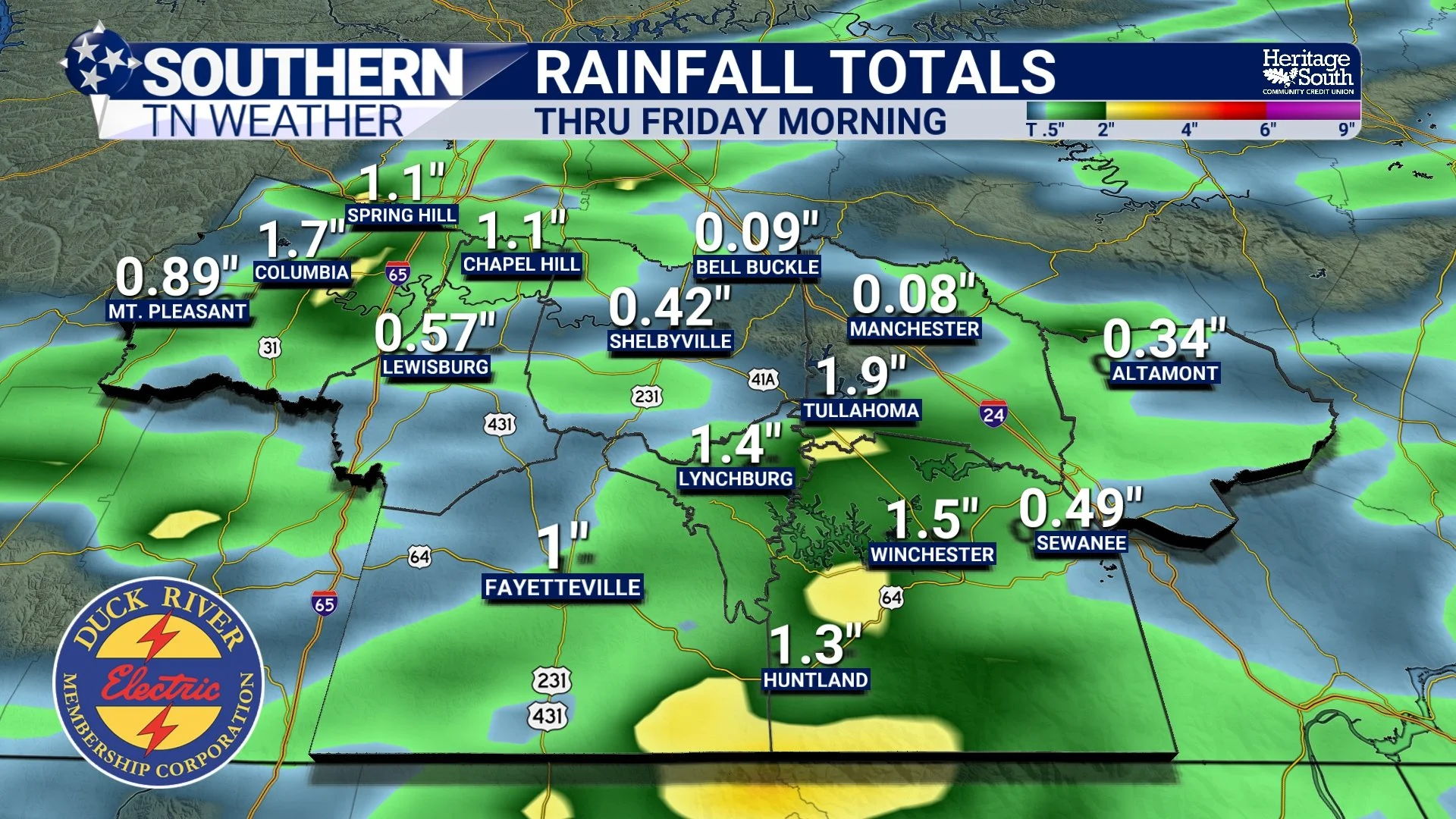
RAIN TOTALS - THRU FRIDAY MORNING
Then We Get a NICE Weekend
Once we get tonight's storms out of the way, our weather takes a much quieter turn. Friday will feature a light northwesterly breeze with highs generally in the upper 80s to lower 90s. A stray shower can't be completely ruled out, particularly across our southern counties, but severe weather isn't expected and most of us should have a much quieter day.
The weekend looks even better. Saturday should be mainly dry with highs again in the upper 80s to lower 90s, and the humidity won't be nearly as oppressive as some of the ridiculous stuff we've dealt with lately. Sunday looks primarily dry as well.
The biggest difference may actually be noticeable after sunset. Overnight temperatures should fall into the low to mid-60s for many communities this weekend, with some of the higher elevations potentially dipping into the 50s early next week. No, fall isn't here yet—but Mother Nature is at least giving the air conditioner a chance to catch its breath. 😂 Temperatures should gradually return closer to normal by the middle of next week, and a few additional shower and thunderstorm chances may eventually return as disturbances move through our northwesterly flow aloft.
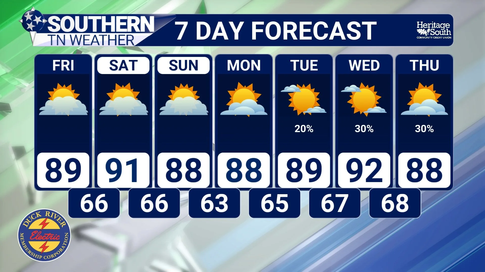
STNWX - 7 DAY FORECAST
The Bottom Line 🧾
⛈️ More storms are possible: Additional scattered thunderstorms are expected to develop this afternoon and evening. Not everyone will get rain.
⚠️ Severe weather threat: Most of the region has at least a Marginal Risk (Level 1 of 5), with the greater threat focused across our southern counties where a Slight Risk (Level 2 of 5) extends into portions of Southern Middle Tennessee.
💨 Main concern: Damaging wind gusts are the primary severe weather threat. Hail, frequent lightning and very heavy rainfall are also possible.
⏰ Timing: The main window is now through roughly 9 PM. The severe threat should decrease after sunset as instability fades.
🌧️ Localized flooding: Any storm could produce a tremendous amount of rain in a short period of time, especially where heavy rain already fell this morning.
🌤️ Weekend: Much quieter weather arrives Friday and sticks around through the weekend, with highs mainly in the upper 80s to lower 90s and more comfortable overnight temperatures.
📰 Reminder: The Southern Tennessee Weather Blog, presented by Heritage South Community Credit Union, is updated Monday through Friday with fresh, locally tailored forecasts you can trust.
