
Dew Point: What Actually Is It and Why Do We Use It?

The Southern Tennessee Weather Blog is proudly presented by Heritage South Community Credit Union.
We Help When Others Won’t!
Visit https://www.heritagesouth.org/ today to see how HSCCU can help YOU!
If you've followed my forecasts for any length of time, you've probably heard me talk about dew points—especially during the summer. I'll say dew points are in the 70s and it's miserable outside, or I'll get excited when a front knocks them down into the 50s and 60s. But what the heck is a dew point in the first place? Why do meteorologists care so much about it? And if your weather app already tells you the relative humidity is 65%, why do we need ANOTHER number to tell us how much moisture is in the air?
It turns out the dew point is one of the most useful numbers we have for describing atmospheric moisture, and once you understand it, you'll probably start paying more attention to it too.
First Things First: What Is the Dew Point?
The National Weather Service defines the dew point as the temperature to which air would have to cool, assuming its pressure and moisture content remain constant, before it becomes saturated. In simpler terms, it's the temperature at which the air becomes saturated enough for water vapor to begin condensing into liquid water.
Here's an easy example. Suppose the temperature outside is 80° and the dew point is 65°. If that same air cools overnight without its moisture content changing, once the temperature approaches 65°, the relative humidity approaches 100%. If conditions are right, that's when you can start seeing condensation in the form of dew or fog. That's also where the name comes from. When grass, cars and other surfaces cool below the dew point, water vapor can condense onto those surfaces as those little droplets we call dew.
And here's an important rule: the dew point cannot be higher than the air temperature. When the temperature and dew point are the same, the air is saturated and the relative humidity is 100%.
WEATHER WHY - DEW POINT
Where Did the Idea of Dew Point Come From?
Dew point isn't some new number meteorologists invented for your weather app. Scientists have been trying to quantify moisture in the atmosphere for centuries. One of the biggest names in its development was English scientist John Dalton—yes, the same John Dalton famous for his work on atomic theory and Dalton's law of partial pressures. Research published by the American Meteorological Society notes that Dalton introduced a reliable method of determining the condensation point around 1802. His method was wonderfully simple: cool water in a container and watch for the temperature at which condensation first appears on the outside.
At first, the measurement was referred to by names such as the “vapor point” or “point of condensation.” The term “dewpoint” came into use not long afterward, appearing in the scientific literature by the early 1800s. The basic idea behind Dalton's experiment still works today. If you've ever pulled an ice-cold drink out of the refrigerator and watched water droplets form on the outside, you've basically watched the dew-point concept in action. The cup didn't leak—the surrounding air was cooled enough that some of its invisible water vapor condensed into liquid water on the cold surface.
Why Not Just Use Relative Humidity?
This is probably the most important part of the whole discussion. Relative humidity is useful, but it is also one of the most misunderstood weather numbers. That's because relative humidity depends heavily on temperature. It tells us how close the air is to saturation at its CURRENT temperature rather than simply telling us how much moisture is present. As the temperature changes during the day, the relative humidity can change dramatically even if the actual amount of water vapor in the air changes very little.
Imagine a muggy summer morning. The temperature is 72° with a dew point near 70°. The relative humidity may be around 90%. By afternoon, the temperature climbs into the lower 90s while the dew point stays around 70°. Suddenly the relative humidity may be closer to 40 or 50%. Did half of the moisture magically disappear? Nope.
The temperature changed, which changed the air's relative humidity. The dew point, meanwhile, stayed relatively steady and continued telling us that there was plenty of moisture in the air. The National Weather Service gives another great example: 30° with a 30° dew point produces 100% relative humidity, while 80° with a 60° dew point produces only about 50% relative humidity. Yet the 80° day will feel MUCH more humid because there is considerably more water vapor in the air.
That's why, when I'm trying to tell you how muggy the air mass actually is, dew point is usually much more useful than relative humidity.
So What Do Dew Point Numbers Actually Feel Like?
There's no magical line where everyone suddenly agrees the air feels humid. Some people tolerate humidity better than others, and our perception also depends on temperature, sunshine, wind and what we're doing outside. Still, dew point gives us a pretty good summertime comfort scale:
55° or lower: Dry and comfortable
Upper 50s to lower 60s: Generally comfortable, with a little more moisture noticeable
Mid to upper 60s: Humid and increasingly muggy
70° to 74°: Very humid and uncomfortable
75° and above: Oppressive
Around 80°: Welcome to the devil's armpit
Those aren't official warning thresholds, but they're a useful way to interpret the number. The National Weather Service generally describes dew points at or below 55° as dry and comfortable, 55–65° as increasingly sticky, and 65° or higher as containing lots of moisture and becoming uncomfortable. That's why you'll sometimes hear me get excited about a summertime front even when temperatures aren't dropping very much. If we're 91° with a dew point of 75° one afternoon and 89° with a dew point of 61° the next, the thermometer barely changed—but the air can feel COMPLETELY different.
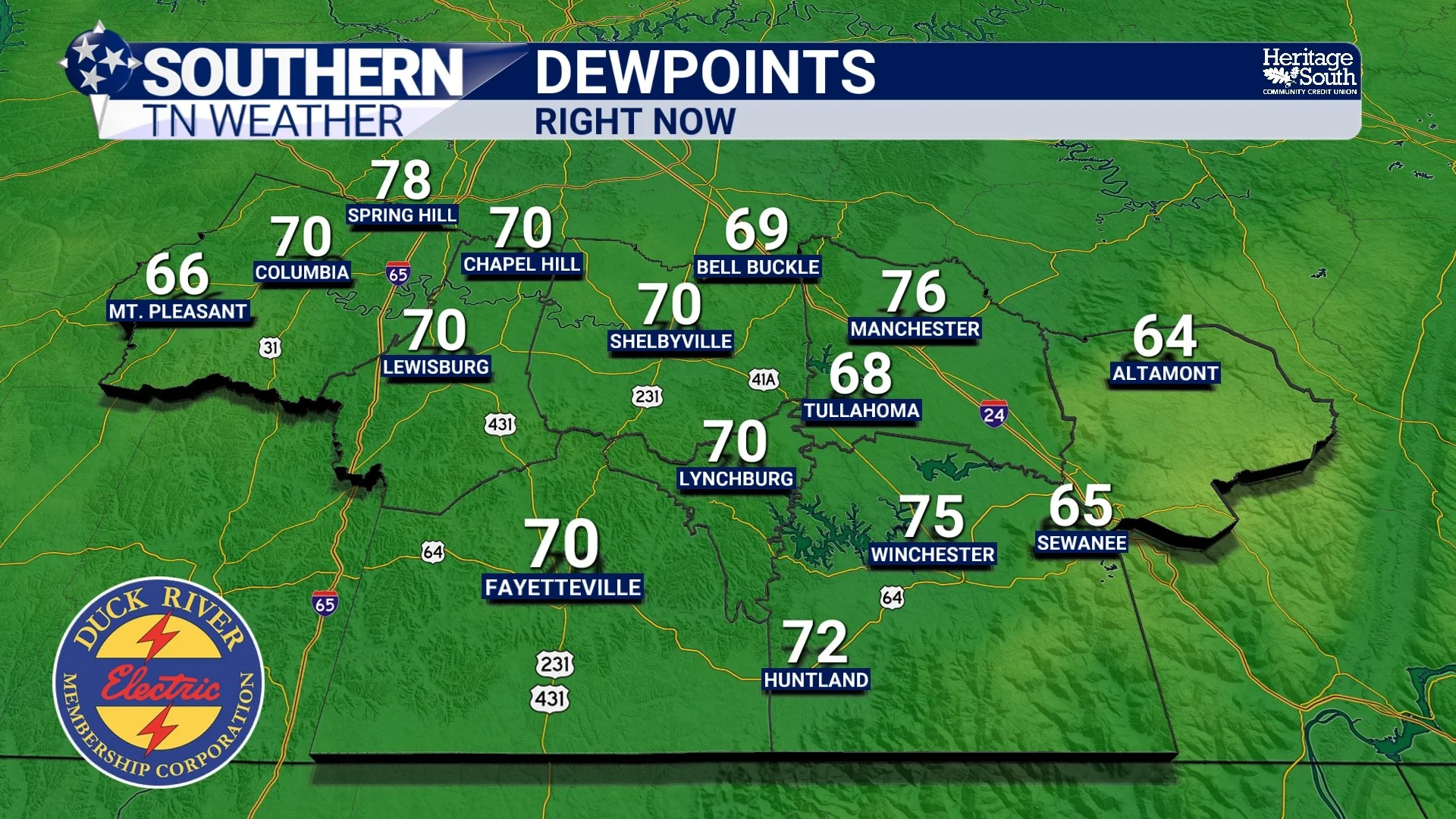
DEW POINTS - RIGHT NOW
Dew Point Is About More Than Comfort
Meteorologists aren't staring at dew-point maps just to determine whether you're going to complain about your hair when you walk outside. 😂 Atmospheric moisture is an incredibly important ingredient in weather forecasting. Dew points help us identify moist and dry air masses, and sharp changes in dew point can reveal boundaries in the atmosphere. One of the more dramatic examples is a dryline, where very moist air can sit immediately beside dramatically drier air. Those moisture boundaries can sometimes become a focus for thunderstorm development.
Dew point is also important when we're evaluating thunderstorm potential. Warm temperatures combined with rich low-level moisture can help create instability, which provides thunderstorms with fuel. A 90° afternoon with dew points in the mid-70s gives us a very different storm environment than a 90° afternoon with dew points in the 50s.
We also use the relationship between temperature and dew point when forecasting fog and low clouds. The difference between the temperature and dew point is called the dew-point depression. When that gap becomes very small (particularly overnight with clear skies and light winds) the air is approaching saturation and fog becomes more likely. That doesn't mean the overnight low will ALWAYS equal the dew point, but the dew point can also provide a useful clue about how far temperatures may be able to fall if the air mass doesn't change significantly.
How Do We Measure It Today?
Dalton didn't have an automated airport weather station, satellite network or fancy electronic humidity sensor in 1802. Thankfully, we've upgraded a little since then. Modern weather stations commonly measure temperature and humidity electronically, and dew point can then be calculated from those observations. Meteorologists can map dew points across huge areas, follow moisture surging northward from the Gulf, watch drier air move in behind a front, and see sharp moisture boundaries evolve in near real time.
That's why dew point appears everywhere in meteorology—from routine surface observations and forecasting to aviation, fire weather and severe-weather analysis. It gives us a convenient, temperature-based way to describe the moisture content of an air mass without the wild daily swings you'll see from relative humidity simply because the temperature went up or down.
Why I Talk About Dew Points So Much
This is really the practical takeaway from today's blog. If I tell you tomorrow's relative humidity will be 45%, that number doesn't tell you much by itself unless you also know the temperature. But if I tell you dew points are falling from the mid-70s into the lower 60s, you immediately know a noticeably drier air mass is moving in. It's also why I sometimes call a day “less humid” even though your phone says the morning relative humidity is 90%. A cool morning can have very high relative humidity while containing far less water vapor than a brutally muggy summer afternoon with a lower relative humidity percentage.
So the next time you see DEW POINT on your weather app, don't scroll right past it. During the summertime especially, it may tell you more about how the air is going to feel than the relative humidity does. And speaking of dew points... today's forecast gives us a pretty good real-world example.
A Quick Look at the Forecast
We're enjoying a quieter Friday after yesterday's storms, but the humidity hasn't completely packed its bags just yet. Surface dew points are still hanging around the lower 70s across portions of Middle Tennessee this afternoon, so there's still a muggy feel despite somewhat drier air beginning to work into the region. Most of Southern Middle Tennessee should remain dry today. A few showers or isolated thunderstorms remain possible, with the better chances generally east of Interstate 65 and toward the Cumberland Plateau. A light northwesterly breeze will continue as highs generally reach the upper 80s to lower 90s.
Tonight is where another dew-point lesson comes into play. Skies should become mostly clear and winds will turn light or calm, allowing temperatures to cool efficiently. As temperatures approach the dew point overnight, patchy fog may develop by Saturday morning, especially in valleys, rural areas and other sheltered locations.
Saturday looks pretty good overall. Another weak disturbance moving through our northwesterly flow could squeeze out a few showers or an isolated thunderstorm, but rain chances remain low for most of the area. Highs should once again generally stay in the upper 80s to lower 90s. By Sunday, dew points should fall farther into the 60s for more of the region, which should provide a noticeable improvement compared with some of the ridiculous humidity we've dealt with lately. Temperatures this weekend will run slightly below normal, with overnight lows generally falling into the 60s. Another round of patchy fog will be possible Sunday morning.
The pattern becomes a little more active again next week. Temperatures should return close to seasonal norms while disturbances riding through northwesterly flow bring isolated to scattered shower and thunderstorm chances Tuesday through Thursday. It's far too early to pin down exactly which communities will see rain on any particular day, but we'll fine-tune those details as we get closer.
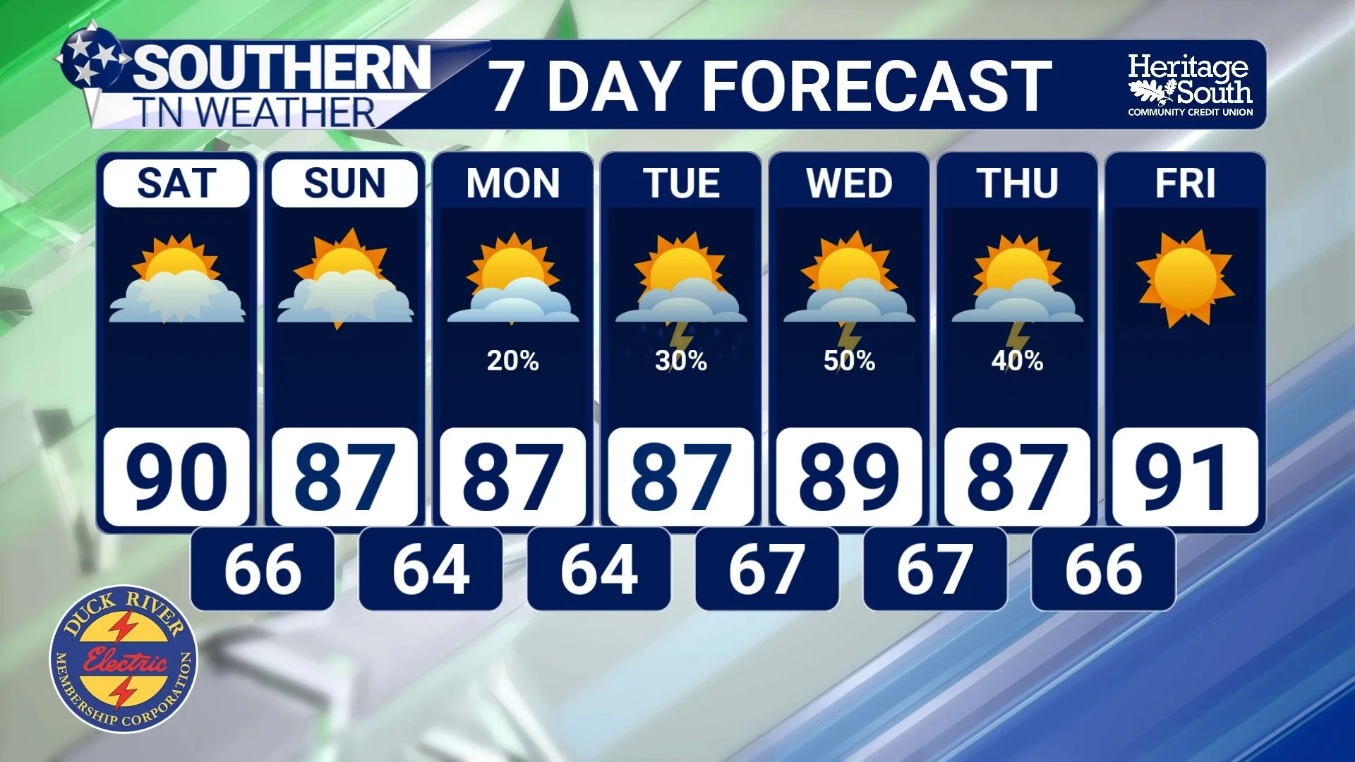
STNWX 7-DAY FORECAST
The Bottom Line 🧾
💧 Dew point measures atmospheric moisture: It's the temperature to which air must cool to become saturated.
📜 It's been around a LONG time: John Dalton developed a reliable method of determining the condensation point around 1802, and the term “dewpoint” followed in the early 1800s.
📊 Why not just relative humidity? Relative humidity changes as the temperature changes. Dew point gives us a much more useful indication of the actual moisture in the air.
🥵 Higher dew point = muggier air: Dew points in the 50s are generally comfortable, the 60s become increasingly humid, and the 70s can feel downright oppressive.
🌫️ Meteorologists use it for much more than comfort: Dew points help us analyze air masses, moisture boundaries, fog potential and thunderstorm environments.
🌤️ This weekend: Mainly dry and slightly below-normal temperatures are expected, with lower humidity gradually working in and patchy morning fog possible.
⛈️ Next week: Temperatures return closer to normal with isolated to scattered storm chances returning Tuesday through Thursday.
📰 Reminder: The Southern Tennessee Weather Blog, presented by Heritage South Community Credit Union, is updated Monday through Friday with fresh, locally tailored forecasts you can trust.
