
Fall Severe Weather Season: Are You Prepared?

The Southern Tennessee Weather Blog is proudly presented by Heritage South Community Credit Union.
We Help When Others Won’t!
Visit https://www.heritagesouth.org/ today to see how HSCCU can help YOU!
We’re still sweating through August, football season is just getting underway, and the first real taste of fall is still several weeks away. So talking about tornadoes and severe thunderstorms may seem a little premature. But here in Southern Middle Tennessee, severe weather isn’t something we only have to think about during the spring.
Once we get into October and November, our part of the country typically experiences what we often call a secondary severe weather season. It’s not usually as active as our primary spring season, but history has repeatedly shown that fall severe weather in Tennessee can pack quite a punch. In fact, National Weather Service climatology for Middle Tennessee shows a noticeable secondary peak in tornado activity centered around November.
With September right around the corner, now is a great time to talk about WHY severe weather makes a comeback during the fall, what this year's developing El Niño could potentially mean, and (most importantly) whether you're prepared before the first watches and warnings start popping up.
Why Do We Have TWO Severe Weather Seasons?
To understand our fall severe weather season, it helps to first understand why spring is so active. Severe thunderstorms need several ingredients, but two of the big ones are instability and wind shear. During the spring, increasingly warm and humid air from the Gulf can surge northward while powerful storm systems and much colder air continue moving across the country. Put those air masses together with strong winds throughout the atmosphere, and you've got the ingredients necessary for organized severe thunderstorms.
Then summer arrives. The jet stream generally retreats farther north, large areas of high pressure frequently dominate the Southeast, and although we certainly get plenty of thunderstorms, the strong wind shear necessary for widespread organized severe weather isn't around nearly as often. But eventually... fall arrives.
As the Northern Hemisphere begins cooling, the jet stream starts strengthening and migrating southward again. At the same time, the Gulf can still provide plenty of warm, humid air to Tennessee.Suddenly, some of those ingredients we lost during the summer begin coming back together.
A strong fall storm system can pull warm, humid air northward ahead of a cold front while much colder and drier air approaches from the west. Winds increase with height, wind shear strengthens, and we can once again create an environment capable of supporting organized severe thunderstorms and tornadoes. In other words, fall can occasionally give us a spring-like atmospheric setup all over again.
November Is the Month I Really Watch
Our secondary season generally runs from October through December, but November sticks out locally. An older but extensive National Weather Service climatology examining Middle Tennessee tornadoes from 1830 through 2003 found that about two-thirds occurred during March, April and May, clearly establishing spring as our primary season. But the data also showed a secondary peak centered around November. And just south of us, the National Weather Service in Huntsville sees the same thing. Its local climatology shows a second spike in tornado activity during October and November, with several significant historical events occurring during the fall season.
So when someone tells you tornado season is over once May ends, that's simply not how severe weather works around here. There really isn't a true "tornado season" where tornadoes suddenly become impossible outside a certain date range. Tornadoes have occurred during every month of the year in Tennessee. Spring is our busiest period, but fall deserves our attention too.
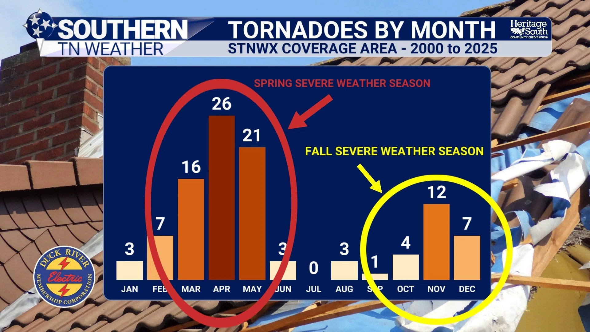
TORNADOES BY MONTH - 2000 to 2025
Fall Severe Weather Can Bring Another Problem: Darkness
There's another reason I take our secondary severe weather season seriously. By October and November, the days are getting MUCH shorter. A severe weather event occurring at 7 PM in April may still happen around daylight or sunset. By November, it's completely dark outside.
Fall systems can also move through overnight or during the early morning hours, and severe weather does not care whether you're awake to see the warning. That's why your warning setup becomes especially important heading into fall. If a Tornado Warning is issued at 2:37 AM, you need something loud enough to wake you up. And that brings us to the most important part of this entire blog.
Are You Actually Prepared?
Don't wait until we're under a Tornado Watch on some random November afternoon to figure out where you're going. Take a few minutes sometime over the next several weeks and get your severe weather plan together.
First, know where your safe place is. Ideally, that's a basement or storm shelter. If neither is available, move to the lowest floor of a sturdy building and choose a small interior room away from windows—something like a bathroom, closet or hallway. Put as many walls between yourself and the outside as possible.
Second, make sure you have multiple ways to receive warnings. Outdoor warning sirens are exactly that—OUTDOOR warning devices. They should never be your only method of receiving a warning inside your home, especially while you're sleeping. Have Wireless Emergency Alerts enabled on your phone. Keep a reliable weather app available. A NOAA Weather Radio with battery backup is another excellent option, especially for nighttime warnings. And yes, you can use the FREE Southern Tennessee Weather app for forecasts, live radar, weather alerts and our live severe weather coverage. 😉
Third, think about what you'll bring into your safe place. Shoes are incredibly important if tornado damage leaves broken glass, nails and debris scattered around your home. Helmets can provide additional protection from head injuries. Keep flashlights handy, make sure you've got fresh batteries and consider keeping portable phone chargers charged. And if you've got children or pets, include them in the plan BEFORE severe weather arrives. You don't want to be chasing Fluffy underneath the bed while a tornado is five miles down the road.
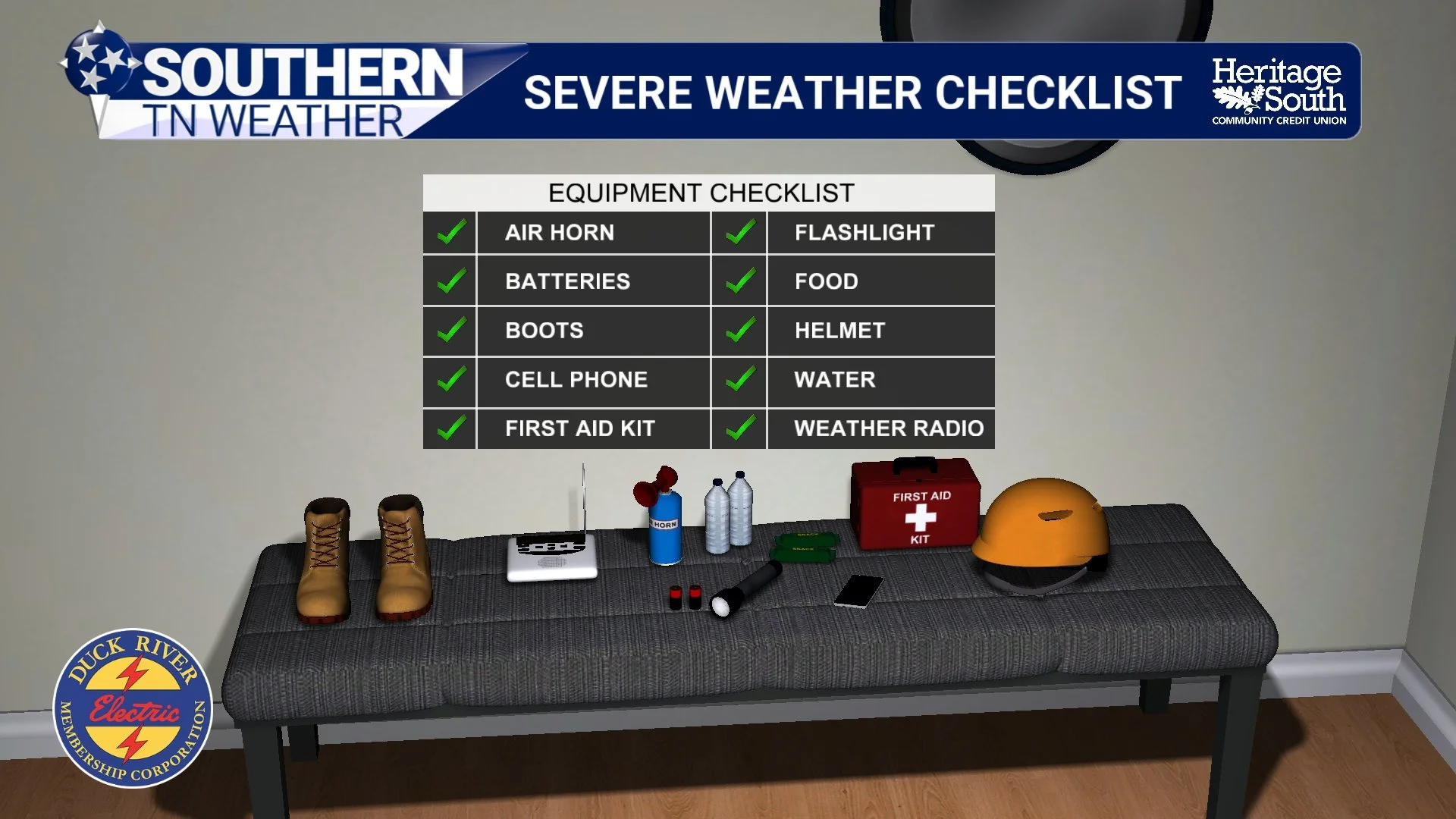
SEVERE WEATHER CHECKLIST
So... What Could El Niño Mean for Fall 2026?
This is where things get interesting—and where we need to be careful about drawing conclusions too early. We are currently in an El Niño, and NOAA's July update indicated that El Niño was expected to strengthen through the remainder of 2026, with a 97% chance of persisting through early spring 2027. El Niño refers to unusually warm ocean temperatures across portions of the equatorial Pacific. That may be thousands of miles from Tennessee, but changes in tropical Pacific temperatures can influence large-scale atmospheric circulation—including the position and behavior of the jet stream across North America.
During a typical El Niño winter, the jet stream tends to become more active across the southern United States. NOAA notes that this southern storm track can make portions of the southern U.S. more susceptible to severe weather. So does that mean we're guaranteed a huge severe weather season this fall? Absolutely not. That's an important distinction.
The relationship between ENSO (El Niño and La Niña) and tornado activity is considerably more complicated than its relationship with something like seasonal temperature or precipitation. Research has found relationships between ENSO phases and the large-scale environments favorable for tornado outbreaks, but the signal varies considerably depending on the season, strength and evolution of the ENSO event, and location. In fact, NOAA has specifically noted that severe weather is inherently "noisy" and much harder to predict seasonally than temperature or precipitation.
So I would NOT look at El Niño and say, "We're going to have a bad fall tornado season." What I would say is that the strengthening El Niño is one of several large-scale pieces we'll watch as we move deeper into fall and eventually winter. It can influence the overall storm track and jet stream, but ultimately our severe weather risk will depend on the individual weather systems that develop. And we won't know the details of those systems months in advance.
The Best Forecast Right Now? Be Prepared.
Whether Southern Middle Tennessee experiences one severe weather event this fall or several, preparation doesn't change. That's really why I'm bringing this up in August. It's MUCH easier to download an app, replace weather-radio batteries, identify your safe place and talk with your family on a quiet Tuesday afternoon than it is when I'm on Facebook saying: "TORNADO WARNING — TAKE COVER NOW!"
Hopefully our secondary severe weather season ends up being quiet. But hope isn't a severe weather plan.
Okay... What About the Weather RIGHT NOW?
We're actually enjoying a brief break from the worst of our recent heat today. Highs this afternoon should generally stay in the upper 80s and lower 90s under mostly sunny skies, and the humidity is noticeably more tolerable behind yesterday's front. Unfortunately, summer isn't finished with us yet.
Wednesday brings the heat right back, with highs climbing into the middle 90s across much of Southern Middle Tennessee. Humidity will increase as well, pushing afternoon heat indices into the upper 90s and lower 100s. Our attention then turns toward Wednesday night and Thursday, when another weather system approaches the region.
Rain and thunderstorm chances will begin increasing Wednesday night before becoming more widespread Thursday morning. There is currently a LOW, but non-zero, risk for a few strong or severe thunderstorms, with gusty to potentially damaging winds and heavy rainfall the primary concerns. The exact severe weather potential remains somewhat uncertain, so we'll watch trends closely over the next 24–36 hours. The front should move east of much of the area by Thursday afternoon, allowing drier air to begin filtering into the region. A few additional showers will remain possible Friday before the weekend turns mainly dry.
And there is some good news for those of us who are about ready to throw August in the garbage: Temperatures should return closer to normal this weekend. We're not talking about fall weather quite yet, but after the heat we've dealt with lately, we'll take our wins where we can get them.
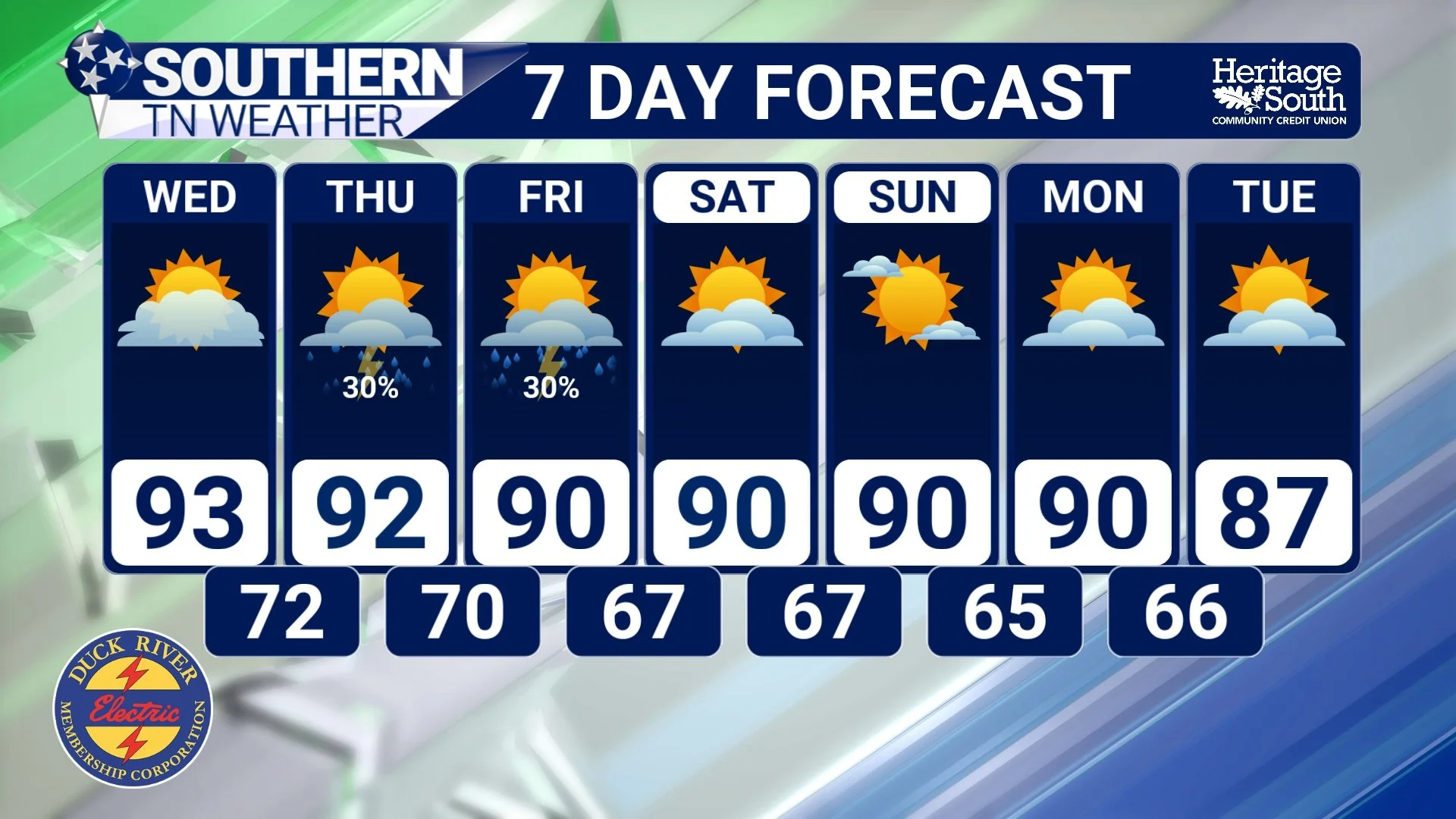
STNWX 7-DAY FORECAST
The Bottom Line 🧾
🌪️ Yes, we have a secondary severe weather season: Severe weather typically becomes more active again during October and November, with a secondary tornado peak around November locally.
🍂 Why? The jet stream strengthens and shifts south while warm, humid Gulf air can still reach Tennessee, occasionally recreating some of the ingredients we see during spring.
🌙 Nighttime weather matters: Shorter fall days mean severe storms can occur after dark, making reliable warning methods especially important.
📱 Prepare now: Know your safe place and have multiple ways to receive warnings—including something capable of waking you overnight.
🌊 El Niño: It can influence the jet stream and storm track, but it does NOT tell us whether Fall 2026 will be an active or quiet severe weather season.
🥵 Wednesday: Summer rebounds with highs in the mid-90s and heat indices approaching or exceeding 100°.
⛈️ Wednesday night–Thursday: Rain and storms return, with a low severe weather threat and gusty winds/heavy rainfall the main concerns.
🌤️ Weekend: Mainly dry weather and temperatures much closer to normal.
📰 Reminder: The Southern Tennessee Weather Blog, presented by Heritage South Community Credit Union, is updated Monday through Friday with fresh, locally tailored forecasts you can trust.
