
A Spring Reset… Cooler Days, Chilly Nights, But Storms Return Next Week

The Southern Tennessee Weather Blog is proudly presented by Heritage South Community Credit Union.
We Help When Others Won’t!
Visit https://www.heritagesouth.org/ today to see how HSCCU can help YOU!
After a stretch of active weather earlier this week, Southern Middle Tennessee has officially settled into a much quieter and noticeably cooler pattern. This is one of those classic post-storm transitions where the atmosphere essentially “resets,” trading stormy conditions for a more stable, calm setup.
And honestly… it’s going to feel really nice.
TODAY INTO TONIGHT: COOLER AIR TAKES HOLD
High pressure is building in from the northwest, and that’s the main driver behind the changes you’re feeling today. High pressure systems are associated with sinking air, which suppresses cloud development and keeps storm activity at bay. At the same time, this particular system is pulling in cooler and drier air from the north. That process is called cold air advection, and it’s the reason temperatures are running below what we’d typically expect for late April.
By tonight, skies will become partly cloudy, and with that drier air in place, temperatures will fall efficiently into the mid 40s to near 50 across much of Southern Middle Tennessee.
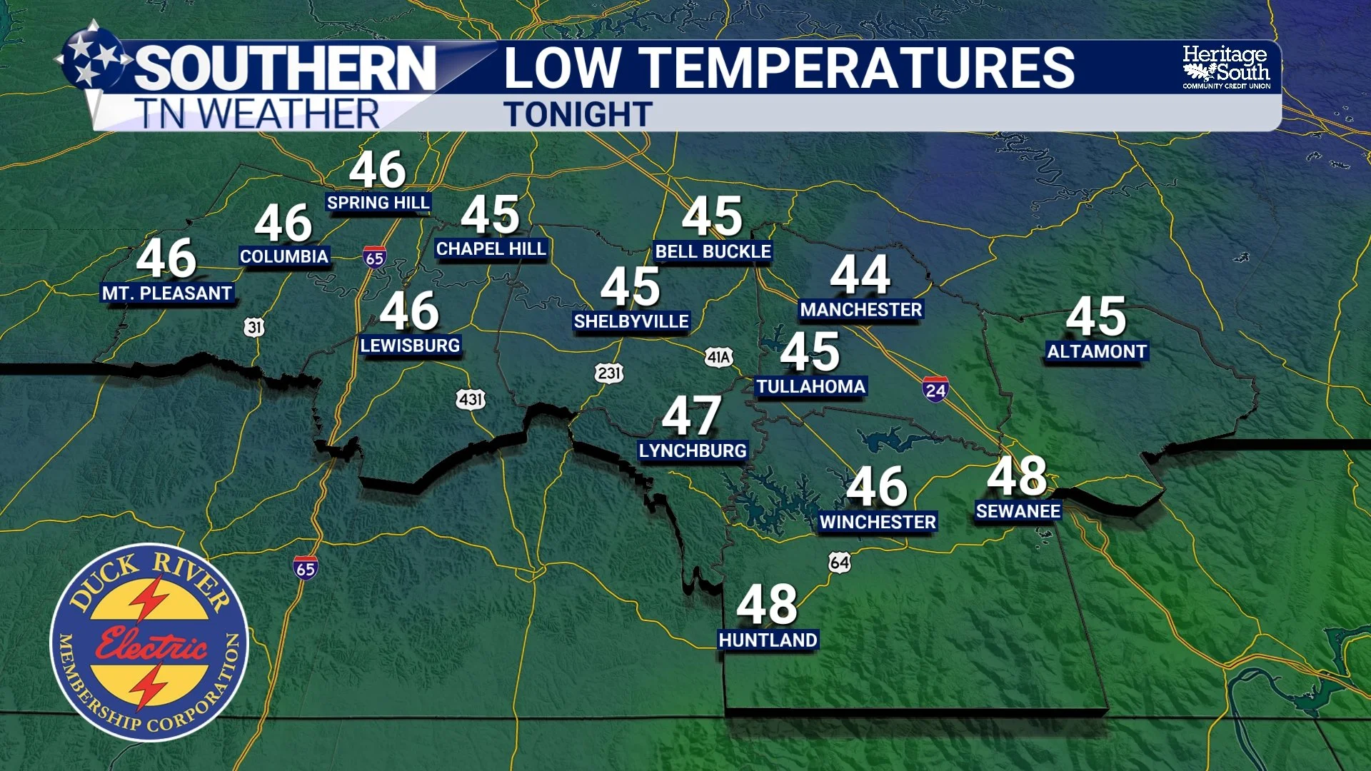
LOW TEMPS - TONIGHT
FRIDAY: QUIET, BUT WATCHING LATE
Friday continues the quiet trend for most of the day. Highs will stay on the cooler side, generally in the upper 60s to near 70 degrees, with plenty of cloud cover around. While the atmosphere remains stable locally, changes will be taking place to our south along the Gulf Coast.
A weak disturbance, tied to a small area of low pressure, will begin tracking eastward along the Gulf Coast Friday night. As that system develops, it will start to push a little moisture northward. For us, that means a low chance of light showers developing after midnight Friday night, mainly across our far southern counties bordering Alabama and up along the Cumberland Plateau.
This is not a high-impact setup. Moisture is limited, and the better forcing for rain stays well to our south. Most locations will either stay dry or see only very light rainfall, generally less than a few hundredths of an inch.
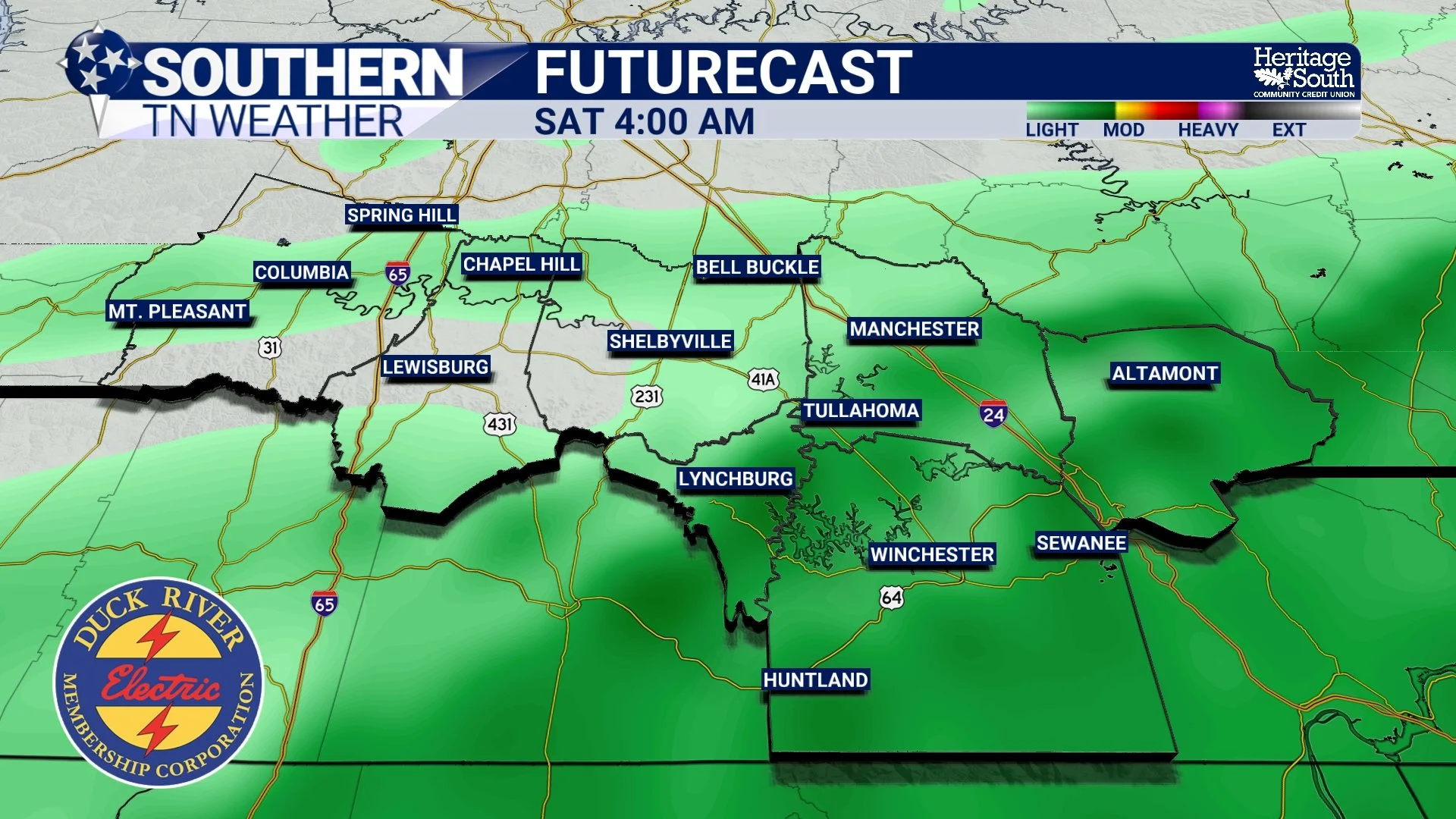
FUTURECAST - SATURDAY MORNING
SATURDAY AND SUNDAY: COOL, DRY, AND COMFORTABLE
Once that weak system slides out Saturday morning, we’re right back into a dry pattern. We should dry out by sunrise on Saturday or shortly after. In fact, this weekend may end up being one of the more comfortable stretches we’ve seen in a while.
Saturday will be the coolest day, with highs only reaching the low to mid 60s. That’s several degrees below normal for this time of year. By Saturday night into Sunday morning, clear skies and light winds will allow temperatures to drop into the upper 30s to low 40s. Some of our colder, outlying areas could even flirt with upper 30s briefly. This setup is known as radiational cooling, where heat escapes efficiently overnight under clear skies and calm winds. I can’t even rule out a few areas of patchy frost by early Sunday morning.
Sunday brings a bit of a rebound, with sunshine and highs climbing back into the upper 60s. Still below normal, but very comfortable overall.
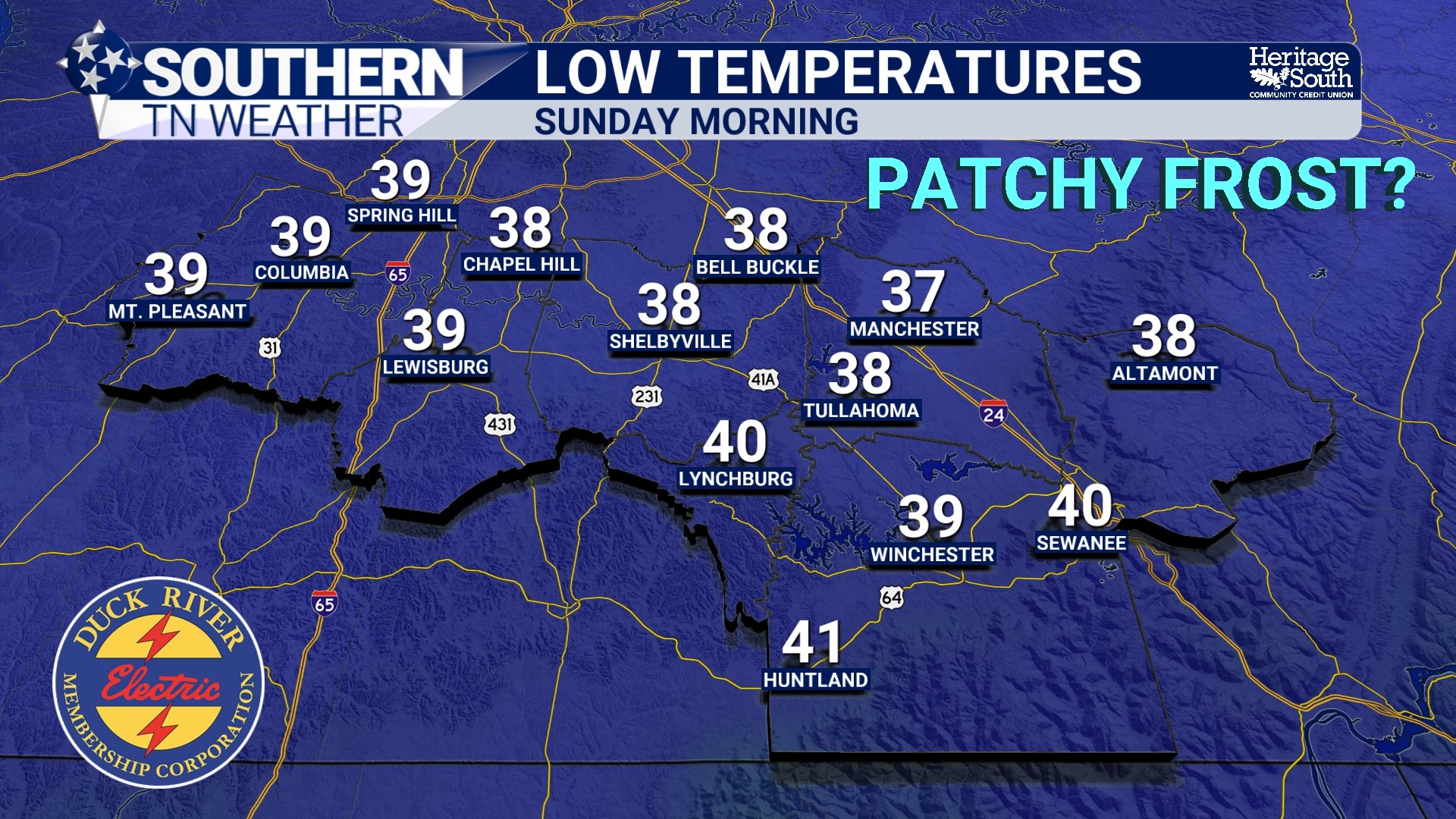
LOW TEMPERATURES - SUNDAY MORNING
EARLY NEXT WEEK: WARMING BACK UP
As we head into Monday and Tuesday, the pattern begins to shift again. High pressure slides east, allowing winds to turn more southerly. That opens the door for warmer air to return, with highs climbing back into the 70s and eventually near 80 degrees by Tuesday. Moisture will also begin to increase, setting the stage for our next weather-maker.
MIDWEEK: THE ACTIVE PATTERN RETURNS
By Tuesday afternoon into Wednesday, a more organized system is expected to develop across the Plains and move east toward the Tennessee Valley. This will bring our next meaningful chance for showers and thunderstorms. While it’s still several days out, the overall signal is clear: the quiet pattern we’re enjoying now will not last forever.
At this point, instability does not look overly impressive, but there are hints that a stronger round of storms could develop as the system moves through sometime Wednesday into Wednesday night. There is still plenty of uncertainty in timing and intensity, so this is something we’ll continue to refine over the coming days.
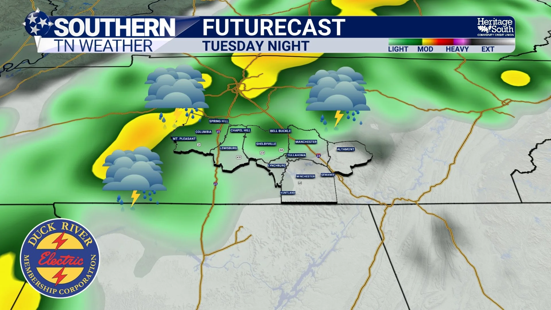
FUTURECAST - TUESDAY NIGHT
The Bottom Line 🧾
Cooler, drier air settles in tonight with lows in the 40s
Friday stays mostly quiet, with a small rain chance late at night
Weekend looks dry, cool, and very comfortable
Chilly mornings possible, especially Saturday night with patchy frost possible
Warmer weather returns early next week
Next better storm chances arrive Tuesday night into Wednesday
📰 Reminder: The Southern Tennessee Weather Blog, presented by Heritage South Community Credit Union, is updated Monday through Friday with fresh, locally tailored forecasts you can trust.