
Spring Heat Building… Records Possible This Weekend

The Southern Tennessee Weather Blog is proudly presented by Heritage South Community Credit Union.
We Help When Others Won’t!
Visit https://www.heritagesouth.org/ today to see how HSCCU can help YOU!
After a quiet return to more typical weather yesterday, the focus now shifts to something a little more interesting — a strong warming trend that could push temperatures near record levels across Southern Middle Tennessee this weekend.
We’re not just warming up… we’re talking about mid 80s in March, which is about 15–20 degrees above normal for this time of year.
Sunshine Today… But the Real Story Is the Pattern
We’re seeing plenty of sunshine across the region this afternoon, with temperatures climbing into the upper 60s to low 70s. It feels great outside, but the more important story is what’s happening in the atmosphere above us. Right now, we’re transitioning into a warm air advection (WAA) pattern, which simply means warmer air is being transported into the region. This is happening because:
High pressure is positioned to our east and south
Winds are turning out of the southwest
That flow is pulling in warmer air from the southern U.S. and Gulf region
At the same time, we still have northwesterly flow aloft, which can sometimes bring disturbances through the region. However, surface high pressure is strong enough to suppress most of that activity, keeping us dry.
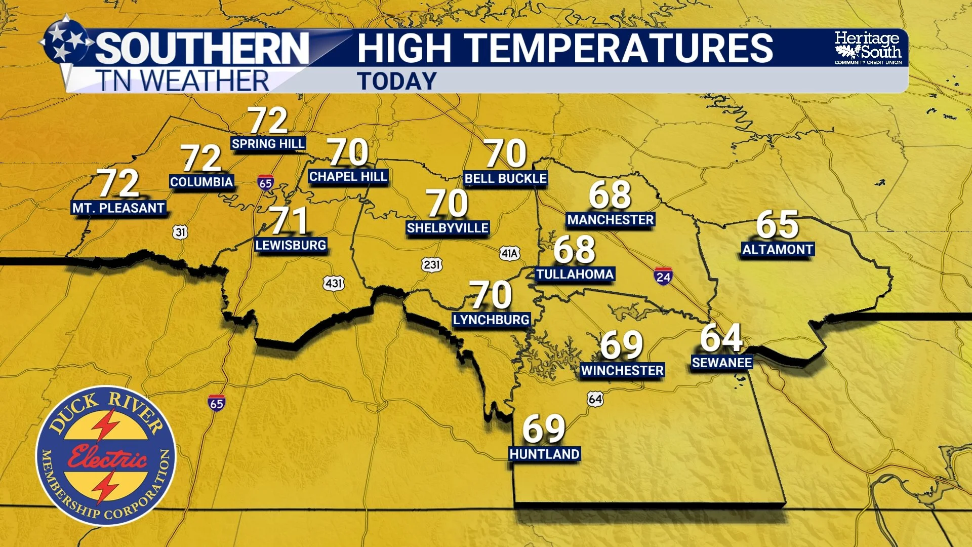
HIGH TEMPERATURES - TODAY
Why It’s Going to Get So Warm
Let’s break this down a little more scientifically… Temperatures this weekend will be boosted by a combination of:
1. Strong Warm Air Advection: Winds just above the surface (around 850mb, or roughly 5,000 feet up) will be transporting much warmer air into Tennessee. When meteorologists look at temperature forecasts, this level is a key indicator of how warm it can get at the surface.
2. Ridging in the Atmosphere: An upper-level ridge (basically a dome of warm air aloft) will build over the region. This leads to sinking air (subsidence), less cloud formation, more sunshine, and efficient warming at the surface.
3. Dry Ground + Sunshine: After our recent stretch of dry weather, there’s less energy being used for evaporation and more going directly into heating the air. Combine that with strong March sunshine, and temperatures can rise quickly.
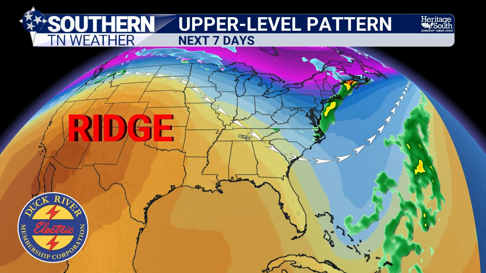
UPPER-LEVEL PATTERN - NEXT 7 DAYS
A Small Wildcard Saturday
Saturday still looks warm and mostly dry, but there is a small wrinkle in the forecast. A weak disturbance (or shortwave) may pass overhead, and with increasing moisture, there could be just enough instability for a few isolated “pop-up” showers or storms. This would be very similar to a summer-type setup, where warm air rises during the afternoon, a boundary or weak disturbance triggers a storm, but coverage remains very isolated. It is important to note that most locations will stay dry and any storms that do develop will be non-severe.
Sunday: Near-Record Heat Possible
Sunday is the day to watch temperature-wise. Forecast highs across Southern Middle Tennessee are expected to reach the mid 80s, with some spots potentially pushing even higher. That puts us 15–20 degrees above normal and well within range of record high temperatures.
There is a 60–70% chance of tying or breaking records in parts of the Tennessee Valley, and while our exact numbers may vary locally, it’s safe to say this will feel more like late May than mid-March.
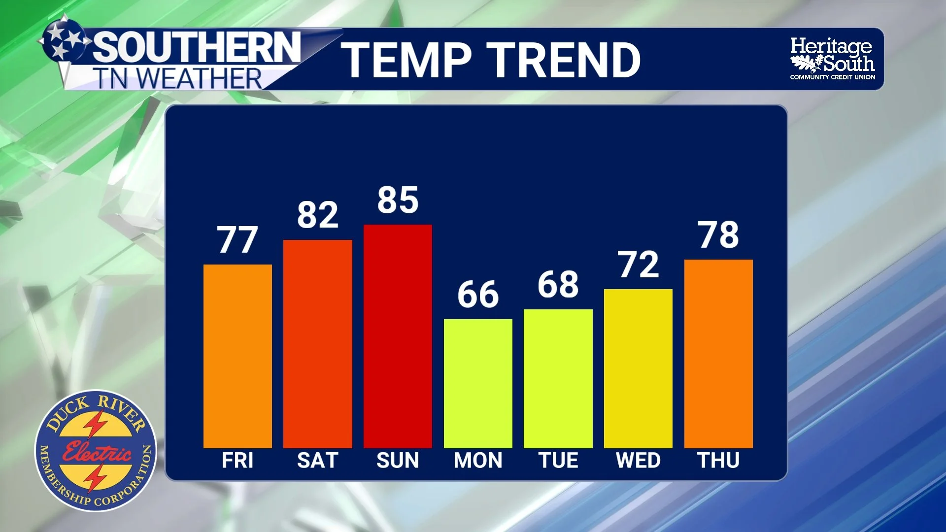
TEMPERATURE TREND - NEXT 7 DAYS
Slight Cooldown Next Week
Behind the front, temperatures will cool slightly — but nothing dramatic. Highs early next week will settle back into the upper 60s to low 70s, which is still mild, just not record-breaking. There is also some uncertainty midweek as small disturbances move through northwest flow, which could bring low-end rain chances Tuesday into Wednesday.
The Bottom Line 🧾
• Dry and warming pattern continues through the weekend
• Highs reach the upper 70s Friday, 80s this weekend
• Near-record warmth possible Sunday
• Small chance of isolated pop-up showers Saturday
• Slight cooldown early next week, but still mild overall
📰 Reminder: The Southern Tennessee Weather Blog, presented by Heritage South Community Credit Union, is updated Monday through Friday with fresh, locally tailored forecasts you can trust.