
Bitter Cold Takes Center Stage as Arctic Air Deepens Across Southern Middle Tennessee

The Southern Tennessee Weather Blog is proudly presented by Heritage South Community Credit Union.
We Help When Others Won’t!
Visit https://www.heritagesouth.org/ today to see how HSCCU can help YOU!
Southern Middle Tennessee remains entrenched in a harsh winter pattern, and as we move toward the end of the work week, the forecast focus is becoming increasingly clear: this weekend’s primary hazard will be dangerous cold, not snowfall. While some light snow or flurries remain possible Friday into Saturday, impacts from any precipitation should remain fairly minor. The cold, however, will not be.
A Cold Weather Advisory is now in effect beginning late Friday night and continuing through midday Monday, as much of Southern Middle Tennessee is expected to remain continuously below freezing for roughly 60 to 70 hours. This type of prolonged cold is uncommon for our region and brings with it a range of secondary impacts that can linger well after skies clear.
The LARGE-SCALE Setup: Why the Cold Is Intensifying
On the large scale, a deep and expanding upper-level trough is digging southward across the eastern half of the country. Embedded within this trough is a large, closed upper-level low currently taking shape over Canada. Over the next 24 to 36 hours, that system will dive southeast into the Ohio and Tennessee Valleys, reinforcing Arctic air already in place across Southern Middle Tennessee. This is not a shallow, surface-based cold event. Forecast soundings show a deep, well-mixed Arctic air mass extending through much of the troposphere, meaning temperatures will struggle to recover even during peak afternoon heating. Once temperatures drop below freezing late Friday, they are expected to remain there through the weekend and into early Monday.
At the surface, strong high pressure building south out of central Canada will tighten the pressure gradient across the region. This will lead to gusty northerly winds, which will play a critical role in driving wind chill values toward (and in some locations briefly near) zero degrees, especially during the overnight and morning hours Saturday and Sunday.
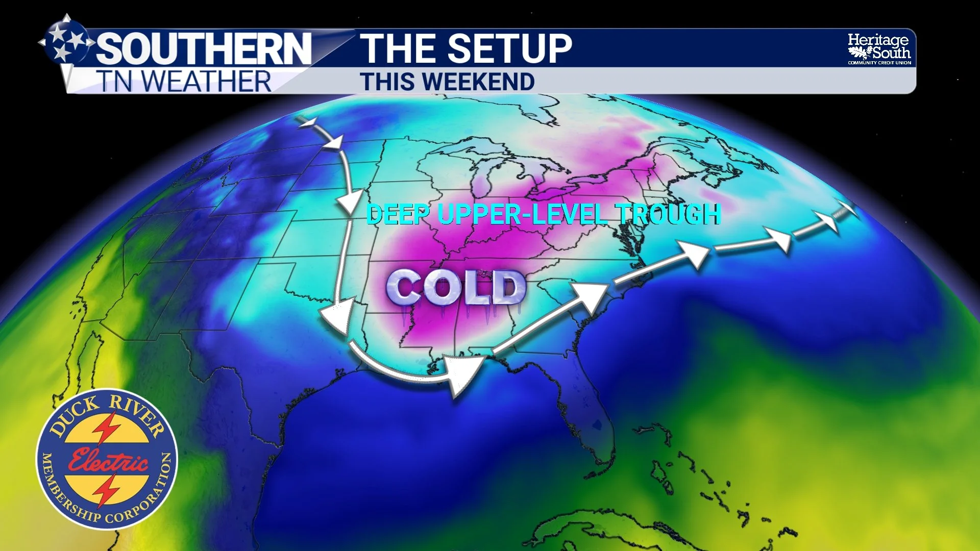
The Setup - This Weekend
Thursday Into Friday: Calm Before the Cold Tightens Its Grip
Thursday will be relatively quiet but still cold. Breaks in cloud cover have allowed temperatures to climb into the upper 30s and lower 40s this afternoon, making this the warmest day we see until early next week. That said, lingering snow and ice on the ground (especially across our northwestern counties) will limit melting, and any improvement will be temporary. By tonight, increasing clouds ahead of an approaching shortwave will overspread the area. Temperatures will again fall into the 20s, and any moisture on roadways will refreeze. Friday marks the beginning of a more impactful stretch. While daytime temperatures may reach the 30s in spots, cold air advection increases through the day, and most locations will fall below freezing by late afternoon or early evening. From that point forward, temperatures are not expected to recover until sometime Monday.
Some of the latest short-range guidance is showing the potential for a few flurries or light snow showers as early as Friday morning as the Arctic air mass continues to deepen. Nothing significant is expected at that time, but it is worth noting that a few flakes may fly. The better chance for snow showers arrives Friday evening into Saturday.
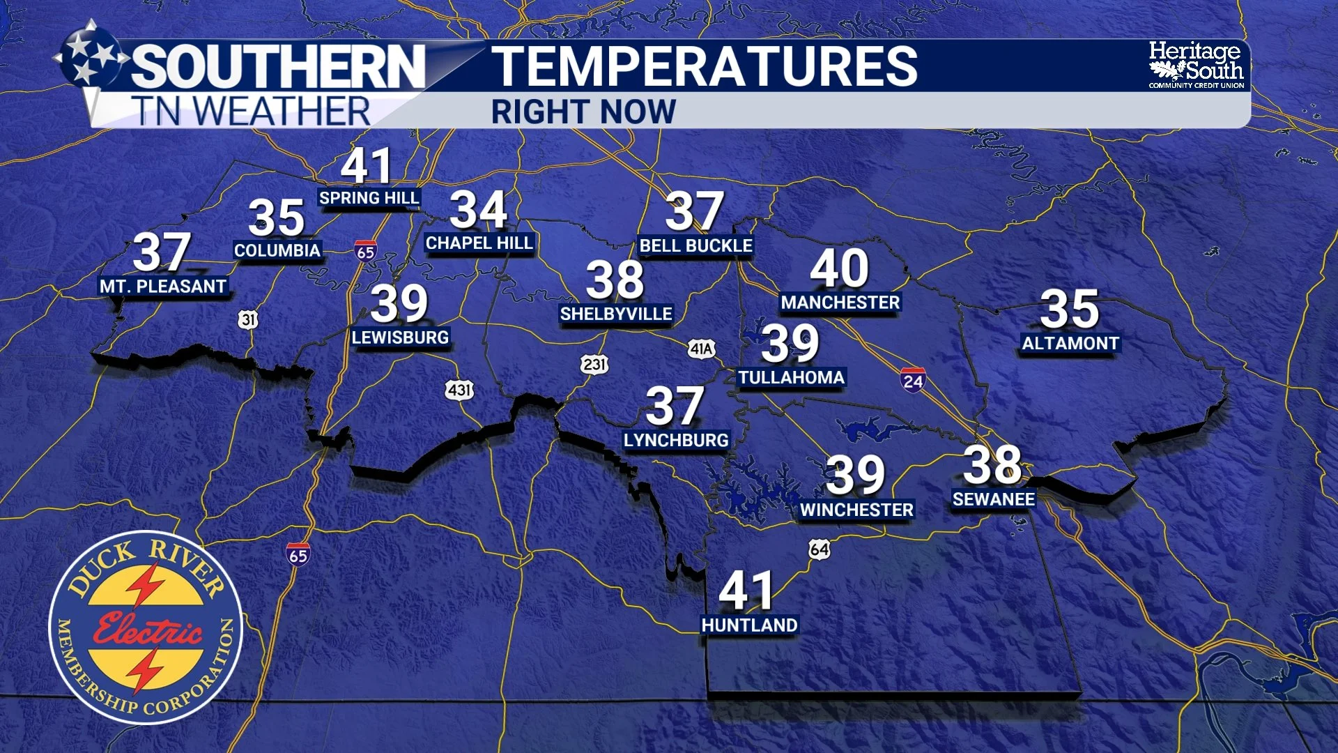
Temperatures - Thursday PM
Light Snow and Flurries: Possible, but Not the Main Story
As the upper-level low swings through the region late Friday into Saturday morning, it will provide enough lift to generate periods of flurries and light snow showers across Southern Middle Tennessee. Moisture with this system remains limited, which keeps precipitation coverage scattered and generally light. The best chance for measurable snowfall is along and east of Interstate 65 (including Bedford, Moore, western Franklin, and Coffee Counties) and across the Cumberland Plateau in Grundy and eastern Franklin Counties. Orographic lift may help squeeze out additional moisture in those areas. Even there, the most likely outcome is a dusting to one-half inch, with a 30 to 50 percent chance of approaching one inch on the Plateau. There is a 70 to 90 percent chance of at least a dusting along and east of I-65.
Importantly, this system does not pose an ice threat, and snowfall rates are expected to remain light. Travel impacts from precipitation alone should be minimal. However, any snow that does fall will occur on very cold road surfaces, and with temperatures well below freezing, nothing will melt quickly.
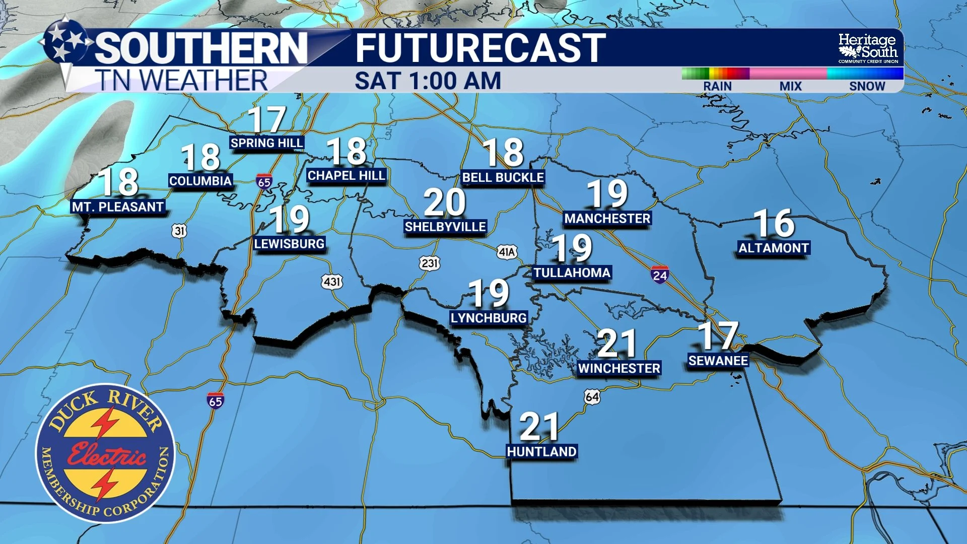
Futurecast - Early Saturday Morning
The Real Concern: Dangerous and Prolonged Cold
The most impactful aspect of this forecast is the severity and duration of the cold. Saturday and Sunday mornings are both trending toward single-digit lows across much of Southern Middle Tennessee, with some sheltered and rural locations potentially falling even lower. Daytime highs Saturday may struggle to reach the upper teens to lower 20s. Combined with persistent winds, wind chill values will hover near or slightly below zero at times.
Perhaps most concerning is how long the cold lasts. From late Friday through at least midday Monday, much of the region is expected to remain continuously below freezing. This significantly increases the risk of refreezing and prolongs winter-related impacts. Even after skies clear, radiational cooling will remain efficient due to existing snow and ice cover, meaning temperatures could locally run colder than forecast in some spots.
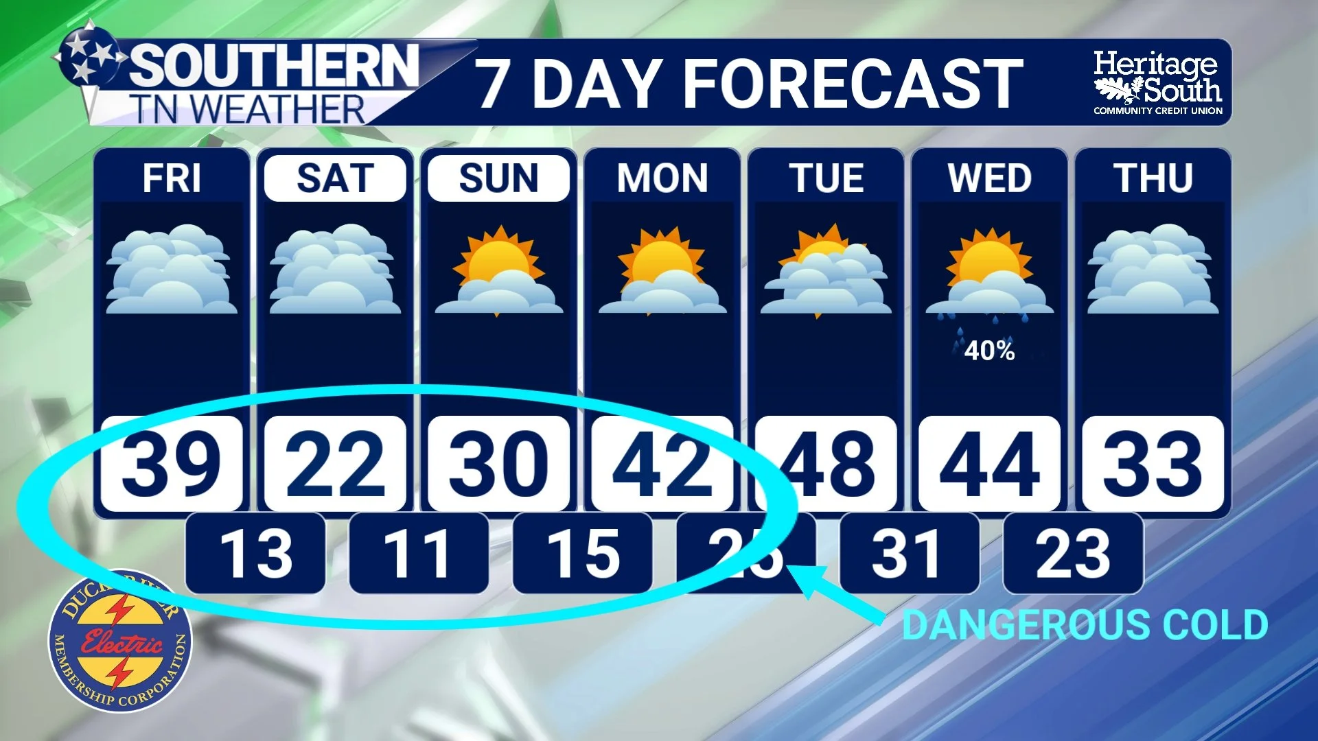
Dangerous Cold
When Do Conditions Finally Improve?
Relief is in sight… just not immediately. By Monday afternoon, temperatures should finally climb back above freezing, with highs in the 40s becoming more common Monday and Tuesday. That should allow a more meaningful and sustained melt to begin. Until then, winter remains firmly in control across Southern Middle Tennessee.
The Bottom Line 🧾
• Dangerous cold dominates the forecast this weekend
• Single-digit lows expected Saturday and Sunday mornings
• Wind chills near 0° at times, especially mornings
• Most areas remain below freezing from Friday evening through Monday
• Light snow or flurries possible Friday into Saturday
• Accumulations generally under ½", up to ~1" possible on the Plateau
• Travel impacts from snow should be minor, but cold-related hazards are significant
• A more meaningful warm-up begins early next week
This is a weekend to focus less on snowfall totals and more on cold-weather preparedness. Protect people, pets, pipes, and property — and continue to use caution on roads, especially overnight and during the morning hours.
📰 Reminder: The Southern Tennessee Weather Blog (Presented by Heritage South Community Credit Union) is updated Monday through Friday with fresh, locally tailored forecasts you can trust