
Small Severe Weather Risk Tomorrow... Latest Details Here

The Southern Tennessee Weather Blog is proudly presented by Heritage South Community Credit Union.
We Help When Others Won’t!
Visit https://www.heritagesouth.org/ today to see how HSCCU can help YOU!
Southern Middle Tennessee remains locked into a humid, unsettled late-May weather pattern, but Friday may feature a slightly more organized round of thunderstorms compared to what we’ve dealt with over the past several days. Most of this week’s activity has been dominated by slow-moving, tropical-style showers and thunderstorms producing torrential rainfall, lightning, and occasional gusty winds with very little organization. Friday, however, may briefly allow a few stronger storms to develop as winds increase aloft and another upper-level disturbance moves through the Tennessee Valley.
This is NOT expected to be a widespread severe weather event, but there is enough concern for isolated stronger storms that portions of the area remain under a Marginal Risk (Level 1 out of 5) for severe weather tomorrow.
Why Friday’s Storms Could Be Stronger
The atmosphere across Tennessee continues looking much more like midsummer than spring. Deep Gulf moisture remains in place across the region while a stalled frontal boundary lingers nearby. At the same time, several small disturbances continue ejecting northeastward through broad southwesterly flow overhead. Over the last few days, thunderstorms have struggled to organize because wind shear has remained weak. Storms have mostly pulsed up randomly during the afternoon before collapsing under their own heavy rainfall.
Friday looks a little different. Forecast guidance shows stronger low and mid-level winds developing across the Tennessee Valley Friday afternoon, especially east of Interstate 65. Combined with daytime heating and dewpoints remaining in the upper 60s and lower 70s, this may allow a few storms to sustain themselves longer and briefly organize.
Forecast instability values are expected to climb above 1000 J/kg in some areas Friday afternoon, which is enough energy for stronger thunderstorms if storms can take advantage of it. The overall setup still has several limiting factors though. Lapse rates remain fairly weak, widespread clouds may limit heating in some locations, and storms may already be ongoing during the morning hours. Because of that, the severe threat remains fairly low overall. The main concern with any stronger storms would be isolated damaging wind gusts. While not impossible, tornado potential appears very low and highly isolated.
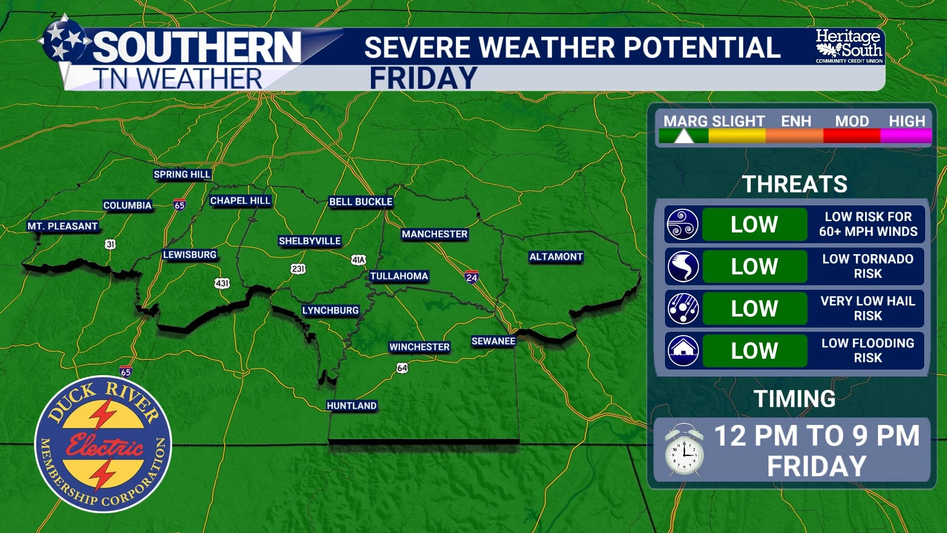
SEVERE WEATHER POTENTIAL - FRIDAY
Storm Timing May Be Complicated
Unlike classic spring severe weather setups with one clean line of storms moving through, Friday’s weather pattern looks messy and somewhat chaotic. One round of showers and thunderstorms is expected to move through Friday morning into early afternoon. Additional development may then occur later Friday evening into Friday night as another disturbance approaches from the southwest.
That means some communities could see periods of rain for several hours while others may briefly clear out and destabilize enough for stronger storms to redevelop later in the day. These smaller-scale details will heavily influence where the strongest storms ultimately occur.
The Atmosphere Remains Extremely Moist
Even with the small severe weather risk tomorrow, heavy rainfall continues being the bigger overall weather story. Atmospheric moisture levels remain extremely high for late May standards. PWAT values (or precipitable water values) continue running between 1.7 and nearly 2 inches across portions of the Tennessee Valley. That means the atmosphere is capable of producing very intense rainfall rates with almost any thunderstorm that develops. One thing that becomes important in patterns like this is something called “warm rain processes.” Dew Points are another way to look at this. Most of the area will see dew points in the 70s tomorrow, which is VERY moist.
In very humid atmospheres, cloud droplets collide and combine much more efficiently within thunderstorms, allowing storms to convert moisture into rainfall very quickly. That’s one reason why these storms can dump torrential rainfall despite not appearing especially severe on radar. This setup is much more supportive of repeated heavy downpours than widespread organized severe weather.
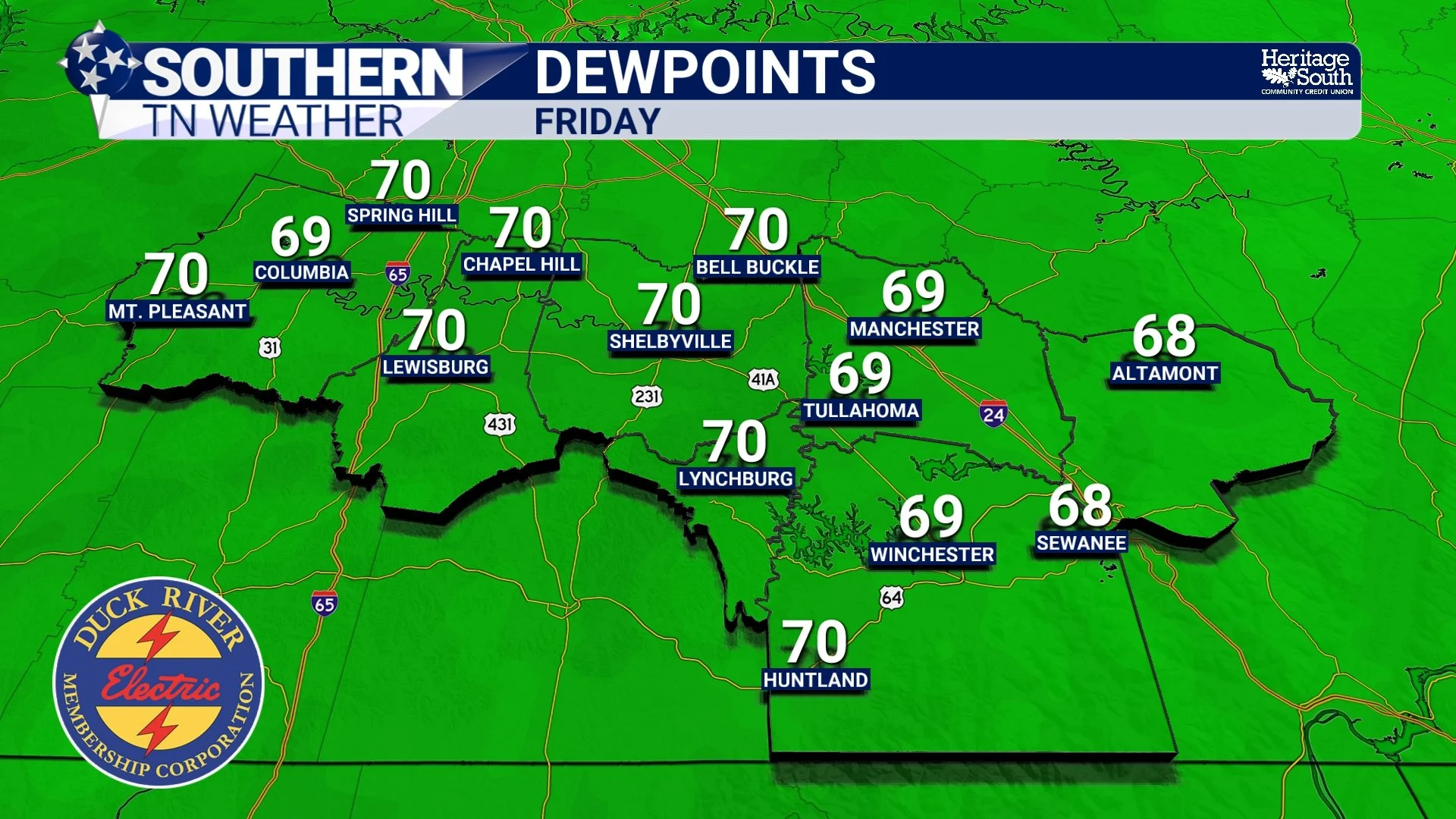
DEWPOINTS - FRIDAY
Rainfall Totals Continue Increasing
Forecast guidance continues showing widespread beneficial rainfall through the holiday weekend and into next week. Many areas across Southern Middle Tennessee are now projected to receive between 2 and 4 inches of rainfall over the next 7 days, with some isolated higher amounts possible where storms repeatedly move across the same locations.
That’s fantastic news considering how dry this spring has been across the region. However, repeated rounds of rainfall also gradually increase the risk for localized flooding issues over time. Right now, widespread river flooding is still not expected. But ponding of water on roads, water collecting in low-lying areas, and isolated flash flooding concerns become more possible if storms repeatedly track over the same locations through the weekend.
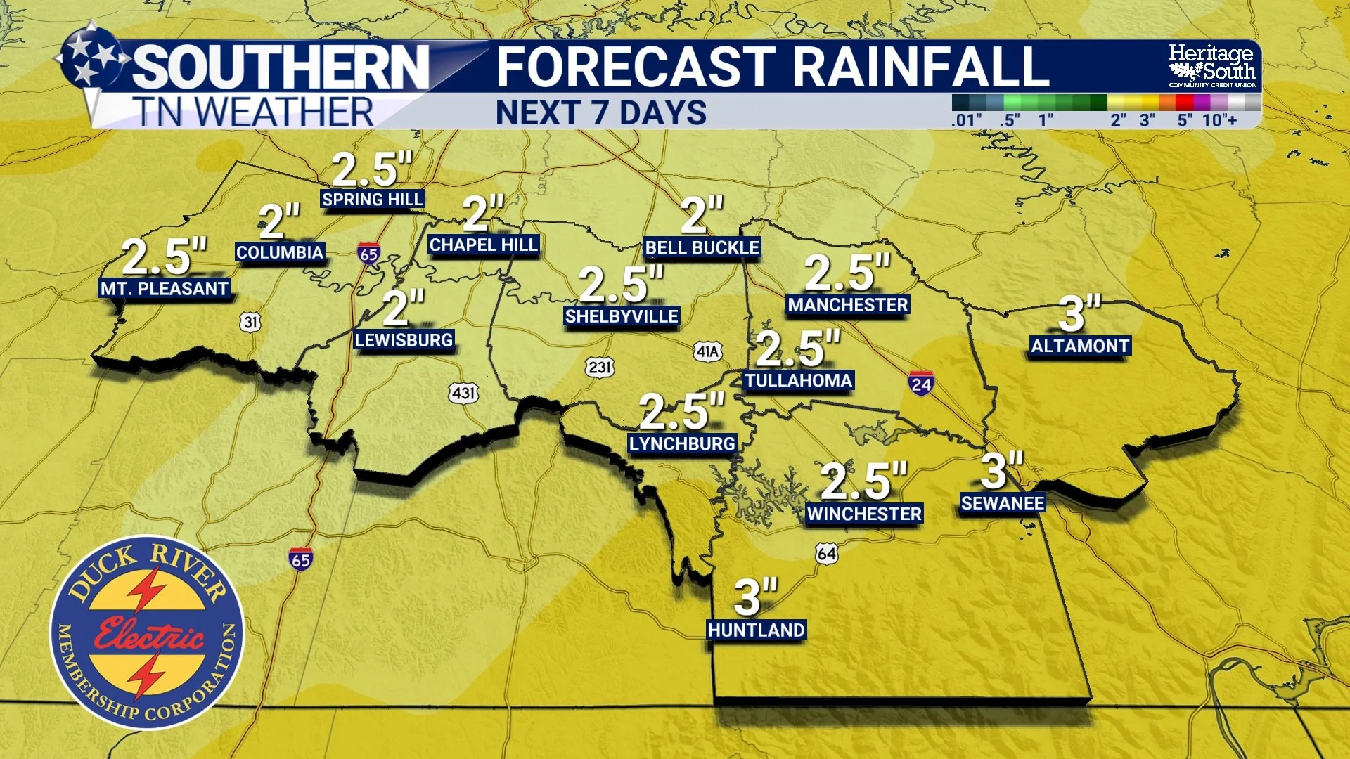
FORECAST RAINFALL - NEXT 7
The Weekend Still Looks Wet
Unfortunately for Memorial Day weekend plans, this overall pattern is not changing anytime soon. The stalled boundary near the region combined with continued southwest flow aloft will keep daily shower and thunderstorm chances in the forecast through at least the next 7 days. There may be occasional breaks in the activity, and it certainly will not rain nonstop the entire weekend, but multiple rounds of showers and storms remain likely.
Temperatures should stay relatively close to seasonal normals with highs mainly in the upper 70s and lower 80s, although humidity levels will continue making it feel fairly tropical outside.
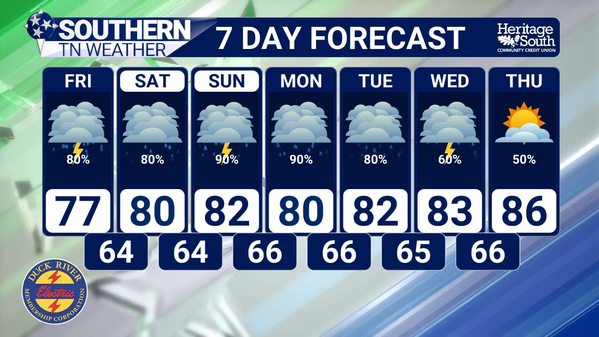
STNWX - 7 DAY FORECAST
The Bottom Line 🧾
A low-end severe weather risk exists Friday across Southern Middle Tennessee.
Isolated damaging wind gusts are the primary severe concern.
Heavy rainfall remains the bigger overall weather story.
Many areas could receive 2 to 4 inches of rainfall through next week.
Localized flooding and ponding concerns will gradually increase over time.
Rain and thunderstorm chances remain elevated through Memorial Day weekend and into next week.
📰 Reminder: The Southern Tennessee Weather Blog, presented by Heritage South Community Credit Union, is updated Monday through Friday with fresh, locally tailored forecasts you can trust.