
Memorial Day Weekend Forecast: Rainy at Times, But Not a Washout

The Southern Tennessee Weather Blog is proudly presented by Heritage South Community Credit Union.
We Help When Others Won’t!
Visit https://www.heritagesouth.org/ today to see how HSCCU can help YOU!
If you’ve got outdoor plans for Memorial Day weekend across Southern Middle Tennessee, the forecast is honestly a little frustrating… but it’s also not a complete disaster. This does NOT look like a nonstop, all-day rain event from now through Monday. At the same time, it’s definitely one of those weekends where you’ll want to keep the radar nearby, have backup indoor plans available, and expect periods of showers and thunderstorms each day.
The atmosphere across the Southeast remains extremely humid and moisture-rich, and unfortunately the overall weather pattern responsible for this week’s rain is barely moving.
Today’s Setup: Why we Are Watching A Few Stronger Storms
Friday’s weather setup is slightly more organized compared to what we’ve dealt with over the past several days. A weak area of low pressure lifting northeast through the Mid-South is helping pull a warm front north of Tennessee this afternoon. Meanwhile, stronger winds just above the surface are spreading into portions of Middle Tennessee as a 35-45 knot low-level jet develops overhead.
That sounds dramatic, but in reality this is still a fairly low-end severe setup overall. The atmosphere remains VERY saturated, cloud cover has limited heating in many spots, and lapse rates remain fairly weak. All of those factors work against widespread severe weather development. However, there is just enough wind shear and instability available for a few storms to briefly rotate or produce isolated damaging wind gusts this afternoon and evening, especially if any storms can briefly tap into pockets of sunshine and stronger instability. A MARGINAL risk (level 1 out of 5) for severe thunderstorms remains in place from the Storm Prediction Center.
Most storms today will simply produce torrential rainfall, lightning, and gusty winds.
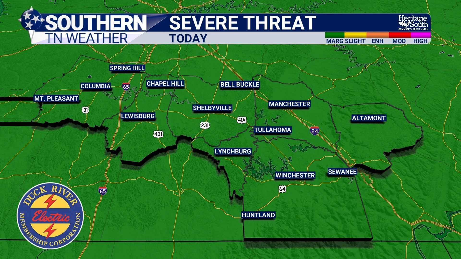
SEVERE THREAT - TODAY
Why The Weekend Forecast Feels So “Summer-Like”
One thing that really stands out about this weather pattern is how much it resembles July instead of May. The atmosphere has transitioned into a deep tropical-style southwest flow pattern, with Gulf moisture continuously streaming northward into the Tennessee Valley. Dewpoints remain in the upper 60s and lower 70s, which is why it feels sticky almost immediately after stepping outside. Overnight temperatures are also staying unusually warm, only dropping into the 60s each night because the humid air mass acts like a blanket and prevents efficient cooling.
What’s interesting is that despite all the humidity, temperatures themselves really are not excessively hot. Persistent cloud cover and scattered storms are keeping highs mostly in the upper 70s and lower 80s. That combination creates what meteorologists sometimes call a “greenhouse atmosphere.” It’s warm, humid, cloudy, and moisture-loaded nearly all day long.
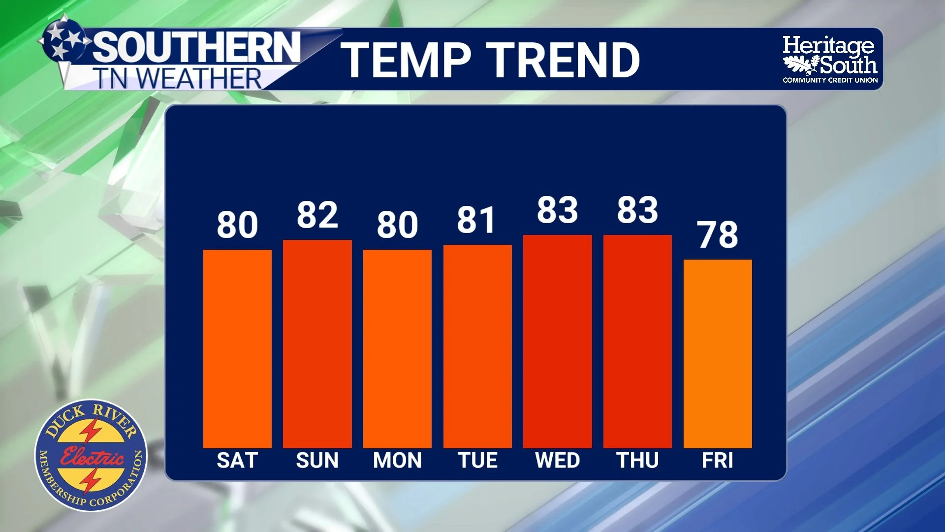
TEMP TREND - NEXT 7 DAYS
Saturday May Actually Have More Breaks Than You Think
A lot of people assume “high rain chances” automatically means constant rain all day. That’s not really how this weekend looks. Saturday may actually feature more dry time than many people expect.
Morning showers and storms remain possible, especially near lingering boundaries left over from Friday’s activity. But as one upper-level disturbance pulls away, there may be a temporary lull in more widespread storm coverage Saturday afternoon and evening. That does NOT guarantee a dry Saturday. Scattered thunderstorms can still redevelop during the heat of the afternoon, especially across the Plateau and eastern portions of Southern Middle Tennessee where instability values may climb a bit higher.
But compared to Friday and Sunday, Saturday currently appears to offer the best chance for longer dry windows.
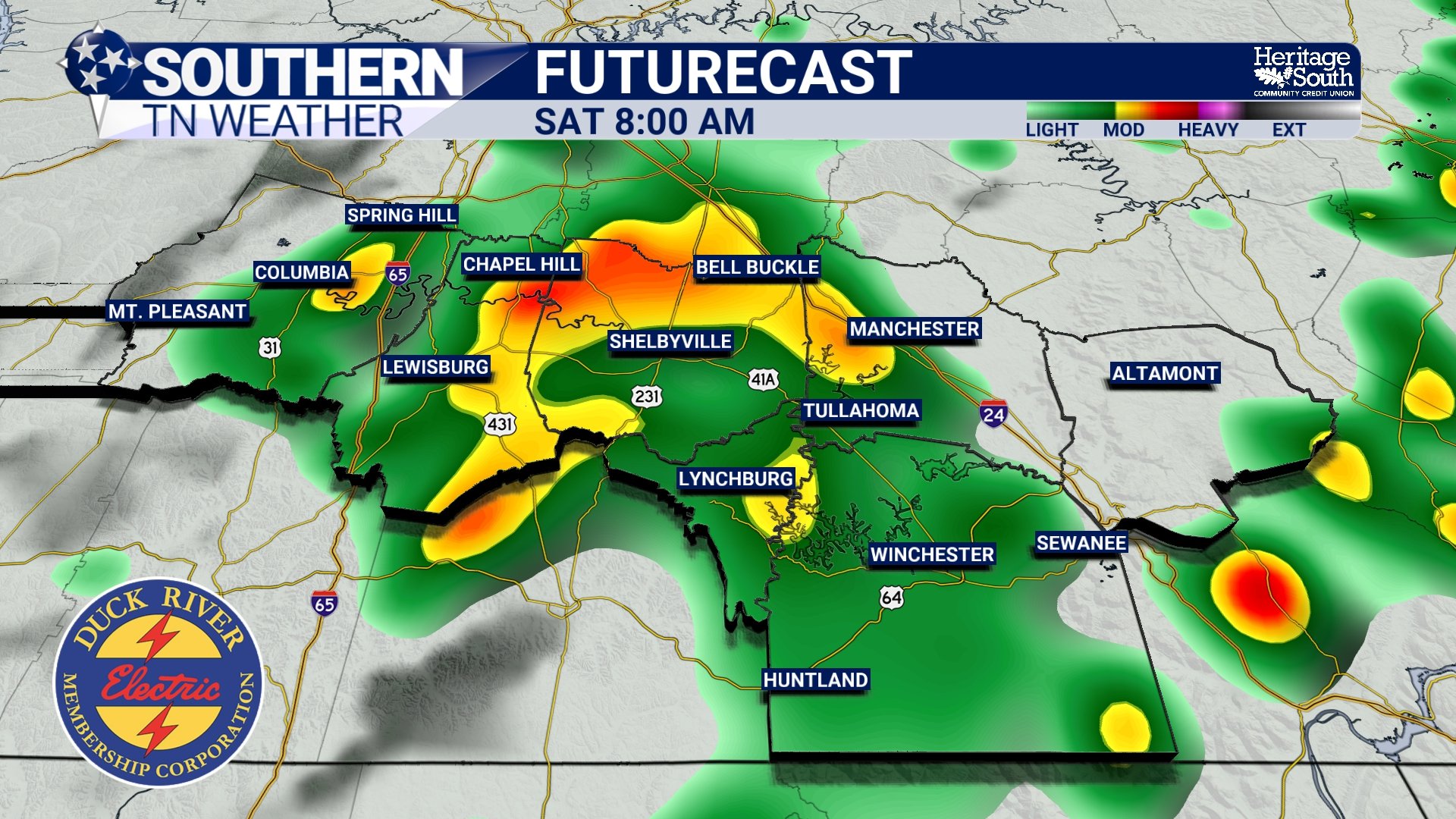
FUTURECAST - SATURDAY MORNING
Sunday and Memorial Day Continue Looking Unsettled
By Sunday, the atmosphere reloads once again. Another strengthening low-level jet develops ahead of a cutoff upper-level low organizing across Texas. That setup pumps even deeper Gulf moisture back into the Tennessee Valley and increases shower and thunderstorm coverage once again Sunday into Memorial Day.
Unlike classic severe weather outbreaks, the atmosphere still lacks strong enough upper-level winds for widespread organized severe storms. However, thunderstorms will remain very efficient rainfall producers. This becomes important because rainfall totals are really beginning to add up across parts of the region.
Why Flooding Concerns Continue Increasing
One thing that has changed over the last 48 hours is the growing concern for localized flooding. Earlier this week, drought conditions helped limit flooding potential because soils could initially absorb much of the rainfall. But after multiple rounds of storms and repeated heavy downpours, some locations are beginning to saturate. This is especially true across portions of Franklin and Grundy Counties, as 2-4 inches of rain has already fallen.
Forecast rainfall totals through next week now range between 2 and 4 inches for many areas, with isolated higher totals possible where storms repeatedly track over the same communities. The important thing to understand is that flooding in this setup will likely be VERY localized.
One town may receive several inches of rain while another only picks up an inch or less depending on where thunderstorms repeatedly develop. This is especially common in tropical-style patterns where storms become “rain efficient” and move repeatedly along leftover boundaries. For now, widespread river flooding still appears unlikely, but ponding on roads, water issues in poor drainage areas, and isolated flash flooding concerns will continue increasing through the weekend.
The Pattern Isn’t Changing Quickly
If you’re hoping for a big cold front to sweep through and completely clear things out… that unfortunately does not appear likely anytime soon. Forecast models continue showing broad southwest flow remaining locked in place across the Southeast well into next week. Multiple weak disturbances will continue riding northeastward through that flow, keeping daily rain and thunderstorm chances around through at least midweek.
The good news is that this pattern IS helping chip away at the spring drought conditions that have plagued Tennessee for weeks. The bad news? It may be awhile before we see several consecutive dry, sunny days again.
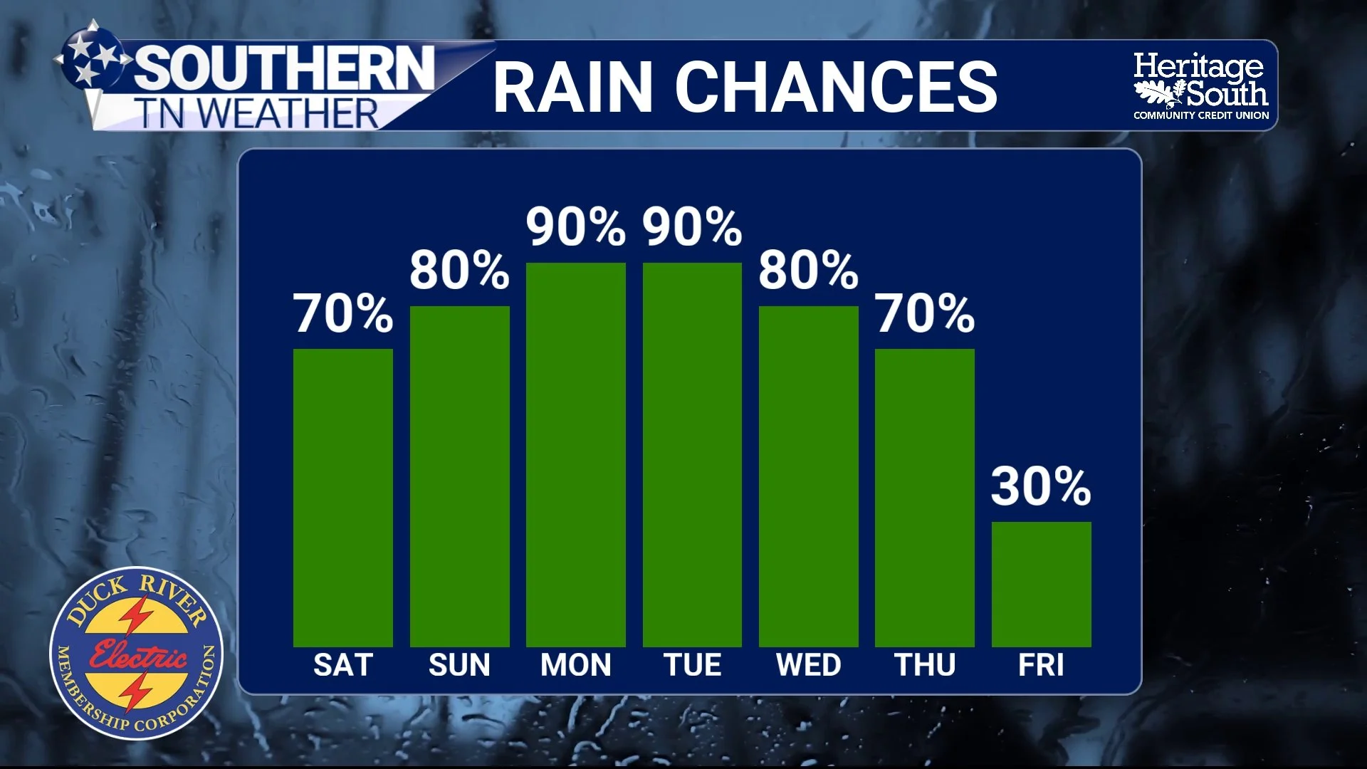
RAIN CHANCES - NEXT 7 DAYS
The Bottom Line 🧾
Memorial Day weekend will feature multiple rounds of showers and thunderstorms.
It will NOT rain nonstop all weekend, but periods of rain and storms are likely each day.
A few stronger storms remain possible Friday afternoon and evening.
Saturday may feature the greatest amount of dry time overall.
Sunday and Memorial Day look wetter with increasing storm coverage again.
Rainfall totals of 2 to 4 inches are possible through next week.
Localized flooding concerns continue gradually increasing.
Temperatures stay near seasonal levels, but humidity will remain very high.
📰 Reminder: The Southern Tennessee Weather Blog, presented by Heritage South Community Credit Union, is updated Monday through Friday with fresh, locally tailored forecasts you can trust.