
The Pattern Has Flipped… And Rain Chances May Not Leave Anytime Soon

The Southern Tennessee Weather Blog is proudly presented by Heritage South Community Credit Union.
We Help When Others Won’t!
Visit https://www.heritagesouth.org/ today to see how HSCCU can help YOU!
If you’ve been waiting for rain, Southern Middle Tennessee is finally entering the kind of weather pattern that can deliver it… and honestly, it may stick around through the end of May. After weeks of drought, stubborn ridging, and storm systems repeatedly weakening before arriving here, the atmosphere has undergone a major pattern shift across the eastern half of the country. Instead of one quick cold front moving through and leaving, we’re now entering a prolonged stretch of humid southwest flow, stalled boundaries, and repeated disturbances moving across the Tennessee Valley.
That setup favors multiple rounds of showers and thunderstorms nearly every single day through the holiday weekend — and possibly beyond.
Today’s Setup: A Front Slowly Sliding South
As of Wednesday afternoon, a weakening cold front continues sagging slowly southward across Tennessee. Showers and thunderstorms have already been ongoing across portions of the area this today especially west of US 231, with additional development expected through the remainder of the afternoon and evening as daytime heating destabilizes the atmosphere. The atmosphere remains VERY moist for May standards.
This morning’s weather sounding from Nashville measured a precipitable water value (or PWAT) of 1.61 inches, with values even higher farther northwest. PWAT measures the total amount of moisture available throughout the atmosphere above a location. Values above 1.5 inches in May are considered quite high and indicate the atmosphere is extremely efficient at producing heavy rainfall. In simple terms… storms do not need to be severe to dump a lot of rain.
The good news is that widespread severe weather still appears unlikely. Wind shear remains weak, lapse rates are only moderate, and overall storm organization should stay fairly limited. A few stronger storms this afternoon could still briefly produce gusty winds around 40-50 MPH, frequent lightning, and torrential downpours, especially along and east of Interstate 65. But overall, this is increasingly becoming a hydro-heavy pattern rather than a classic severe weather setup.
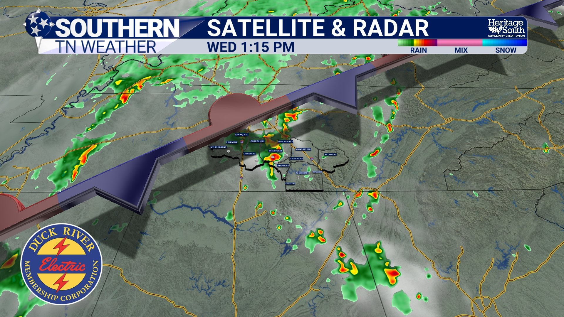
SAT RAD - WEDNESDAY AFTERNOON
The Big Story Is What Happens AFTER the Front
Normally in Tennessee, cold fronts move through, humidity drops, and drier air settles in behind them. That is NOT what’s happening here. Instead of continuing southward into the Gulf, this front is expected to stall near the Tennessee / Alabama / Mississippi border before eventually lifting back north later this week.
That stalled boundary becomes extremely important because it essentially acts as a railroad track for repeated storm systems. Meteorologists often refer to this as a “ring of fire” type pattern. In this setup, strong ridging remains positioned over parts of the Southeast and Gulf Coast while disturbances ride along the northern edge of the ridge through the Tennessee Valley and Mid-South.
The ridge itself suppresses widespread organized severe weather locally, but the edge of the ridge often becomes a breeding ground for repeated thunderstorm clusters and heavy rainfall events. That is exactly the kind of pattern forecast guidance is increasingly showing through Memorial Day weekend.
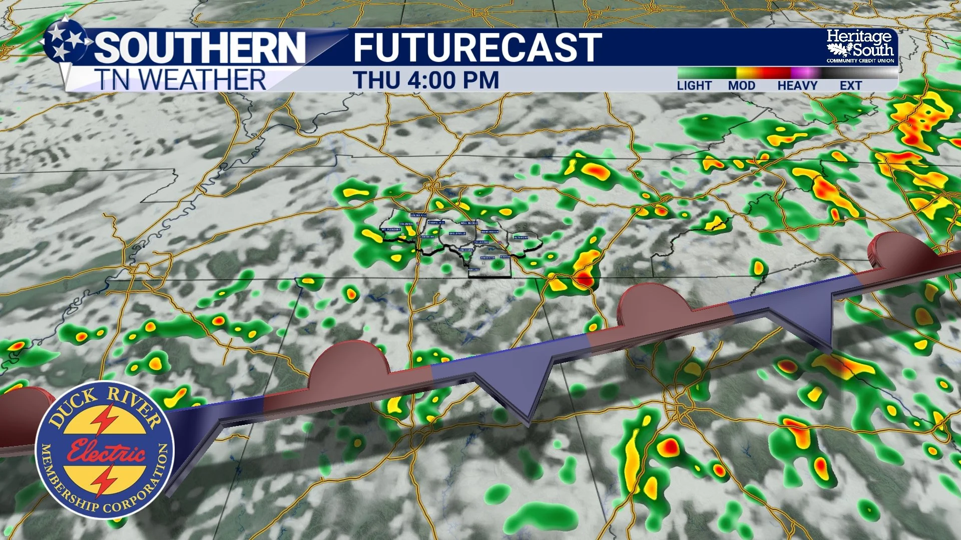
FUTURECAST - THURSDAY AFTERNOON
Why Rainfall Totals Could Vary Wildly
One thing that’s important to understand with this type of setup is that rainfall totals become VERY localized. This will not be one giant shield of steady rain falling evenly across the region. Instead, multiple rounds of thunderstorms will develop along the stalled boundary and within the humid southwest flow. Some communities may get repeated storms moving overhead while others only see occasional scattered activity.
That’s why one town may receive 4 inches of rainfall while another 20 miles away only gets 1 inch. Forecast models continue showing many areas receiving at least 2 inches of rainfall through the weekend, with locally higher amounts possible where storms repeatedly “train” over the same locations. Training occurs when thunderstorms move repeatedly over the same area like train cars following the same track. This becomes much more common when frontal boundaries stall and upper-level winds align parallel to the front. Take a look at the forecasted rainfall totals from our in-house weather model below. Don’t take these amounts as GOSPEL, but it does give a good idea of the variability expected.
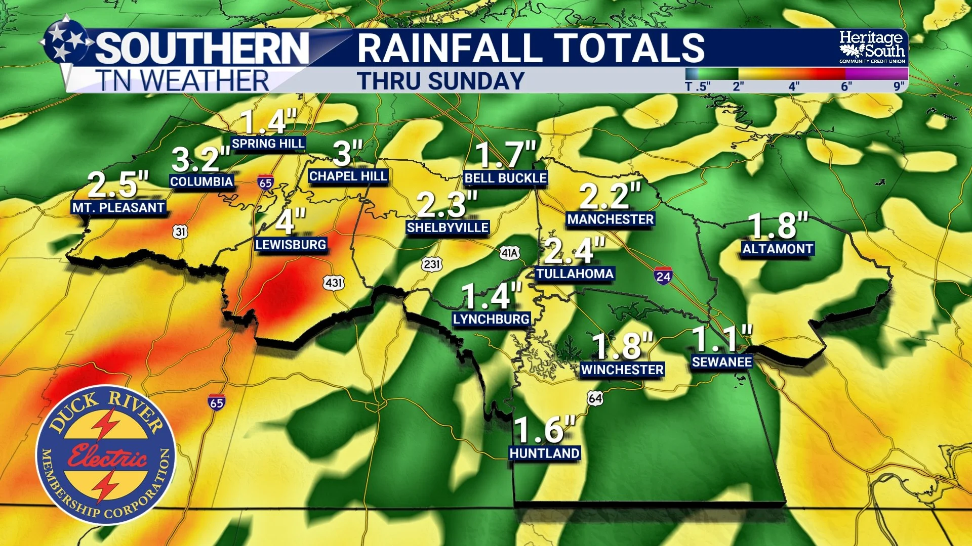
RAINFALL TOTALS - THRU SUNDAY
Flooding Is Slowly Becoming a Concern
The interesting thing about this setup is that widespread river flooding still does not appear likely RIGHT NOW. The reason is because soils across much of Middle Tennessee remain quite dry following the prolonged drought. Rivers, creeks, and reservoirs also started this event below normal. However, localized flooding concerns absolutely increase over time in patterns like this.
Initially, dry ground can absorb rainfall relatively efficiently. But after several consecutive days of repeated storms and heavy downpours, soils begin saturating. Once that happens, additional rainfall runs off much more quickly into low-lying areas, roads, creeks, and drainage systems. That’s why forecasters are increasingly mentioning ponding of water and minor flash flooding concerns later this week and into the weekend. The risk does not come from one massive storm system. It comes from repeated rounds of rain over multiple consecutive days.
Temperatures Stay More “Tropical” Than Hot
One thing many people may notice is that temperatures will actually run slightly cooler over the next several days compared to earlier this week. But don’t confuse “cooler” with comfortable.
Cloud cover and repeated rain chances should keep highs mainly in the upper 70s and lower 80s. However, humidity levels remain very elevated, with dewpoints staying in the mid 60s and lower 70s. That means the atmosphere will continue feeling muggy, sticky, and tropical despite temperatures not reaching the 90s.
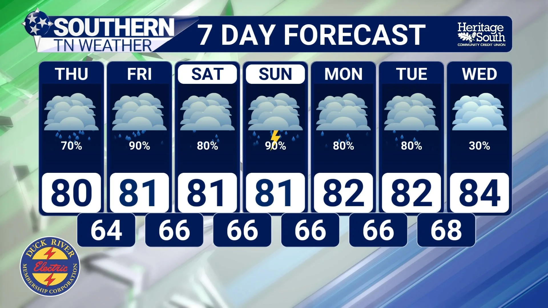
STNWX 7-DAY FORECAST
This Pattern WILL Last Through The End of May
Long-range guidance from the Climate Prediction Center and Weather Prediction Center continues favoring above-normal precipitation across much of the Southeast and Gulf Coast region through at least the end of the month. That does NOT mean it rains nonstop every day.
But it DOES mean the overall atmospheric pattern remains favorable for repeated disturbances, deep Gulf moisture, and elevated rain chances across Southern Middle Tennessee. This is a very different setup compared to the persistent ridging and suppressed rainfall pattern we dealt with for much of spring. And after the drought conditions we’ve battled recently… the atmosphere may finally be trying to make up for lost time.
The Bottom Line 🧾
Rain and thunderstorm chances remain elevated every day through the holiday weekend.
Most areas should receive at least 2 inches of rainfall through the weekend.
Some localized higher totals are possible where storms repeatedly move over the same locations.
Widespread severe weather remains unlikely overall.
Localized ponding and minor flooding concerns may gradually increase later this week.
Humidity levels will remain high despite slightly cooler temperatures.
Forecast guidance favors an active, wetter-than-normal pattern through the end of May.
📰 Reminder: The Southern Tennessee Weather Blog, presented by Heritage South Community Credit Union, is updated Monday through Friday with fresh, locally tailored forecasts you can trust.