
Small Rain Chances Through Sunday

The Southern Tennessee Weather Blog is proudly presented by Heritage South Community Credit Union.
We Help When Others Won’t!
Visit https://www.heritagesouth.org/ today to see how HSCCU can help YOU!
After several days of quiet weather, Southern Middle Tennessee is beginning the transition back into a more active summertime pattern. Fortunately, we're not looking at a washout, but you'll want to keep an eye on the forecast over the next few days as scattered showers and thunderstorms make a return. The bigger weather story, however, may not be the rain at all. Dangerous heat is beginning to take shape for early next week.
A Typical Summer Pattern Returns
Today's forecast is fairly straightforward. Temperatures have climbed into the upper 80s and lower 90s under a mix of sunshine and developing afternoon clouds. While an isolated shower or thunderstorm can't be ruled out this evening, most communities will remain dry.
Beginning Friday, weak disturbances moving across the Ohio Valley will interact with a warm, humid air mass across Tennessee. That combination will be enough to spark scattered showers and thunderstorms, although coverage will remain fairly hit-or-miss. This isn't the kind of setup where everyone gets rain. In fact, some neighborhoods could stay completely dry while others a few miles away pick up a brief downpour.
Friday's Forecast
Friday brings the first appreciable chance for showers and thunderstorms, especially during the afternoon and evening hours. The greatest coverage still appears to be across northern portions of Middle Tennessee, with rain chances gradually decreasing farther south into our coverage area. That said, everyone has at least a chance to see a shower or thunderstorm before the day is over. A few storms could be on the strong side too, especially since the Storm Prediction Center has highlighted areas JUST north of our coverage zone in a level 1 out of 5 MARGINAL risk for severe thunderstorms.
The overall severe weather threat remains fairly low, but if a few storms can become stronger during the afternoon, damaging wind gusts would be the primary concern. The tornado threat across Southern Middle Tennessee remains very low.
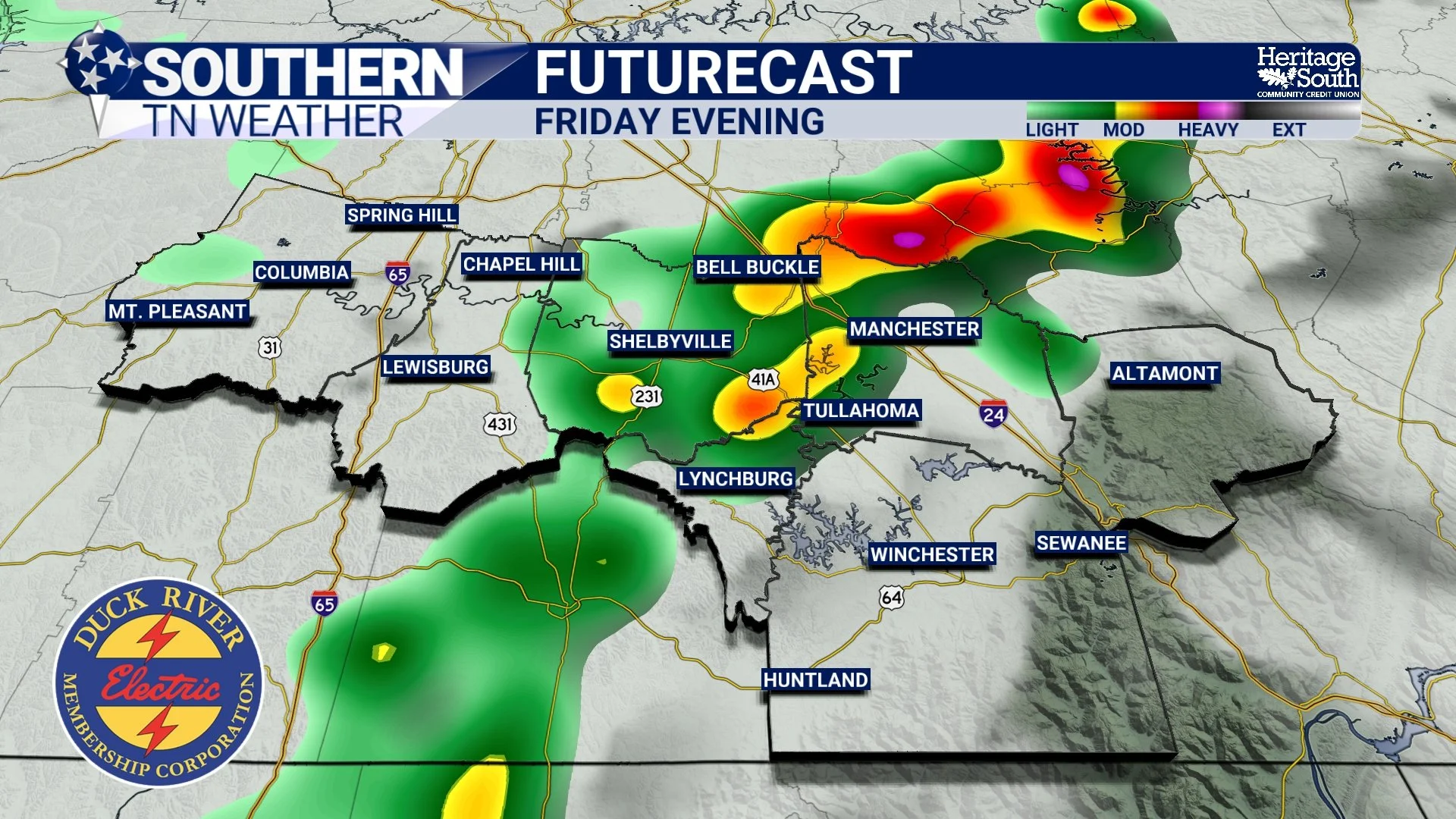
FUTURECAST - FRIDAY EVENING
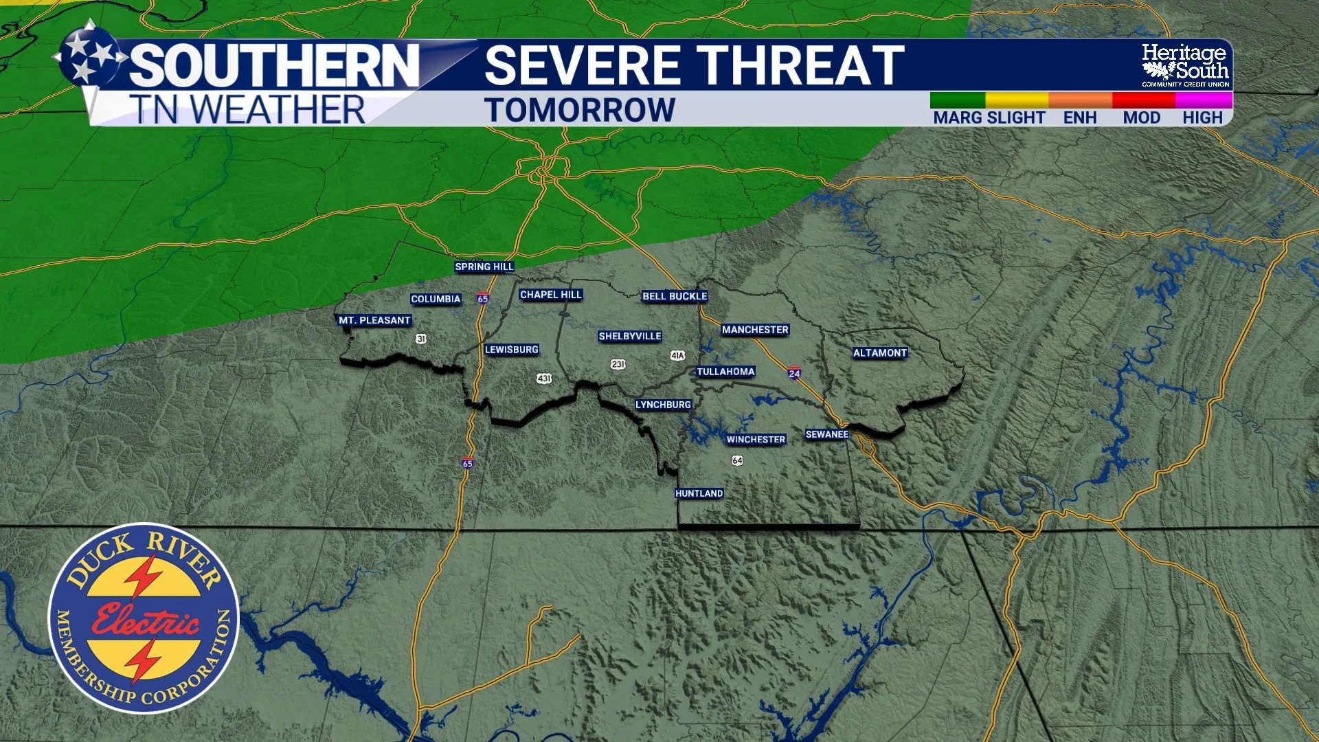
SEVERE THREAT - TOMORROW
Saturday And Sunday
Rain chances continue through the weekend as additional weak disturbances ripple across the region. Saturday currently carries the highest overall rain chances, although that certainly doesn't mean it will rain all day. Expect periods of dry weather mixed with scattered showers and thunderstorms, especially during the afternoon and evening. Once again, the Storm Prediction Center has placed much of Southern Middle Tennessee under another Marginal Risk (Level 1 of 5) for severe weather on Saturday.
The setup looks very similar to Friday. There will be plenty of heat and humidity available to fuel thunderstorms, but wind shear remains fairly weak. Without stronger upper-level support, widespread severe weather appears unlikely. However, an isolated storm could still produce damaging wind gusts.
By Sunday, rain chances begin decreasing somewhat as a strengthening ridge of high pressure starts building across the Southeast. While a few isolated afternoon thunderstorms remain possible, many locations could spend much of the day dry.
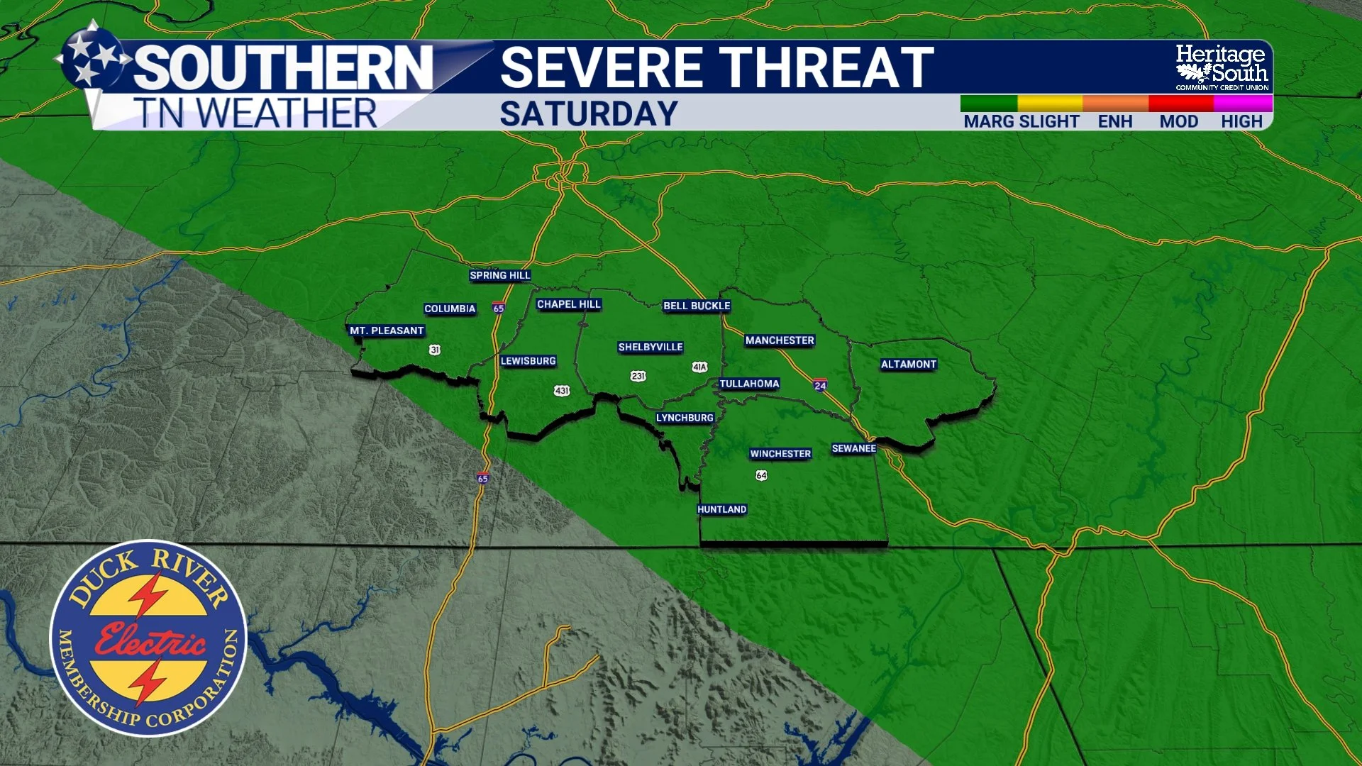
SEVERE THREAT - FRIDAY
The Bigger Story Becomes The Heat
As we move into Sunday and especially next week, attention shifts away from thunderstorms and toward what may become our hottest stretch of weather so far this year. A strong area of high pressure is forecast to strengthen across the southeastern United States. This "heat dome" will allow temperatures to climb well into the middle and upper 90s while also trapping Gulf moisture across the region. That combination of heat and humidity will push afternoon heat index values into the 100° to 109° range across much of Southern Middle Tennessee.
One forecast tool I'm paying particularly close attention to is the National Weather Service HeatRisk product. If you've never heard of it, you're not alone It's a relatively new forecasting tool designed to communicate the overall health impacts of prolonged heat events, not just the temperature or heat index on any one day. Unlike a traditional forecast that simply tells you how hot it will feel, HeatRisk also considers how unusual the heat is for this time of year, how long it lasts, overnight temperatures, and how much opportunity people have to recover between hot days. In other words, it focuses on how stressful the heat will actually be on the human body.
Right now, the National Weather Service is forecasting Major Heat Risk (Level 3 of 4) across much of our area beginning Sunday and continuing into early next week. That level means heat-related illnesses become increasingly likely for anyone spending extended time outdoors, especially those without access to air conditioning or adequate hydration. Older adults, young children, outdoor workers, and people with chronic medical conditions face an even greater risk. Some forecast guidance is even hinting at Extreme Heat Risk (Level 4 of 4) by Tuesday and Wednesday. That is the highest category on the HeatRisk scale and is reserved for dangerous, prolonged heat events capable of affecting nearly everyone if proper precautions aren't taken.
Another factor working against us is the lack of overnight relief. Lows will likely remain in the middle 70s, preventing homes, pavement, and even our bodies from cooling off very much before the next hot afternoon arrives. If forecast trends continue, next week's weather story may not be the chance for an afternoon thunderstorm—it may simply be the dangerous and prolonged heat.
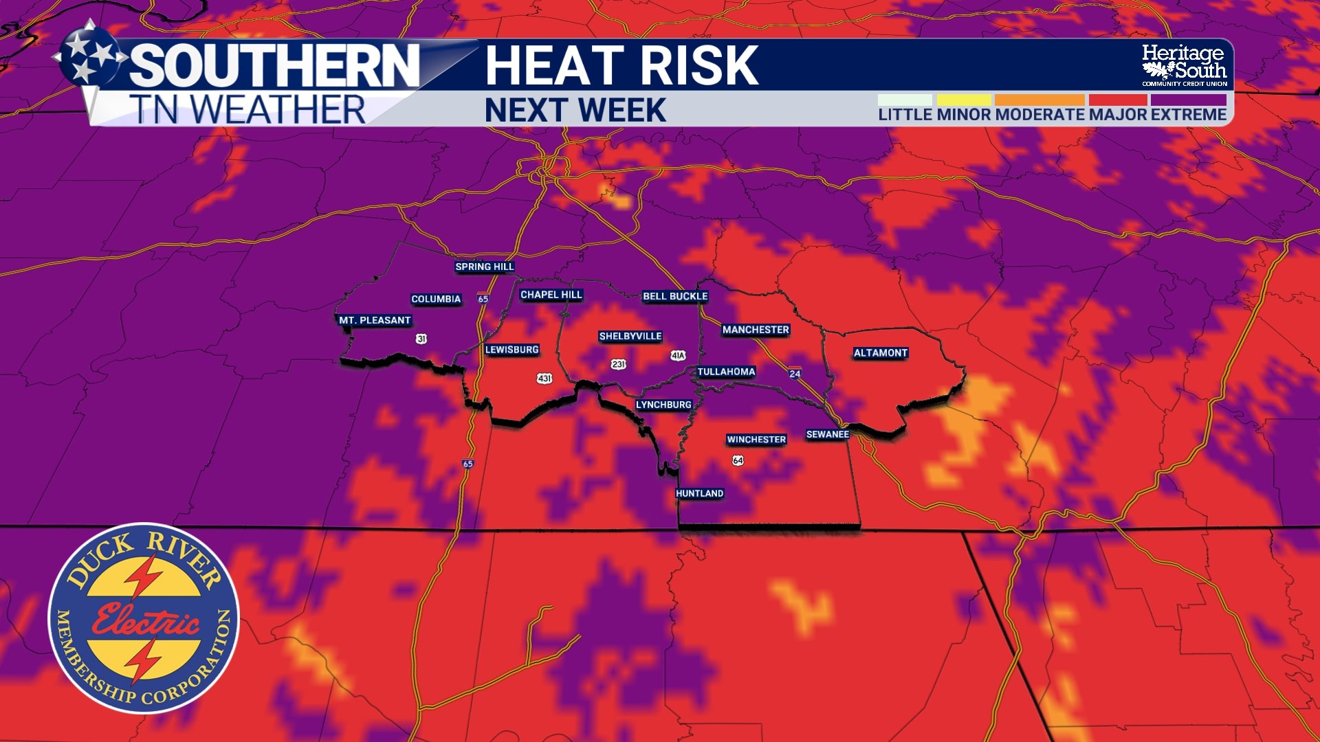
HEAT RISK - NEXT WEEK
The Bottom Line 🧾
Isolated showers and thunderstorms are possible this evening.
Scattered showers and storms return Friday through Sunday.
Not everyone will see rain, and many hours will remain dry.
A few stronger storms Friday and Saturday could produce damaging wind gusts.
The tornado threat remains very low.
Temperatures climb into the middle and upper 90s early next week.
Heat index values between 100° and 109° are becoming increasingly likely.
Dangerous heat may become the biggest weather story by Monday and beyond.
📰 Reminder: The Southern Tennessee Weather Blog, presented by Heritage South Community Credit Union, is updated Monday through Friday with fresh, locally tailored forecasts you can trust.