
Showers and Storms Over the Next 48 Hours
A Few Record Highs Yesterday
I mentioned this on social media yesterday, but I wanted to share it again here for those who follow the blog but not my other platforms. (And if you aren’t following yet, you can find all my social links right here!)
With temperatures running 15–20° above average on Wednesday, several communities broke their record highs for November 19th:
Coalmont: 76° (Old record: 74° in 2016)
Columbia: 77° (Old record: 76° in 2016)
Sewanee: 75° (Old record: 73° in 2016)
Almost every city in our region came within 1–2 degrees of record territory. It’s pretty wild that last week we were talking about record cold highs, and now we’re talking about record warm highs. Ah, the joys of transition seasons in the South!

Observed High Temperatures - WEDNESDAY
The Rest of Today (Thursday)
At the time of writing, Round 1 of our rain event is already ongoing, with showers and some embedded thunder moving across Southern Middle Tennessee. This activity will continue through sunset, gradually transitioning to lighter, scattered showers overnight. It won’t rain nonstop tonight, but there will be plenty of wet weather to get through before things taper off.
Highs today reach the upper 60s to near 70, roughly 10° warmer than a typical late-November afternoon. Clouds will stick around thick tonight, with above-average lows near 60 degrees.
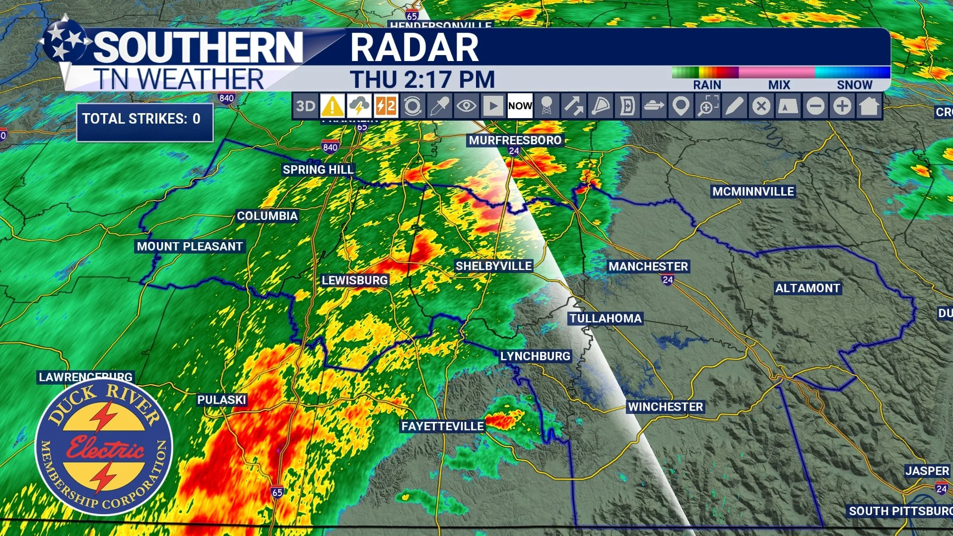
STNWX Radar - Round One this Afternoon
Friday: Rounds 2 & 3
Friday brings two more rounds of rainfall, with the higher-impact period occurring later in the day. This timing aligns well with today’s NWS discussion, which highlights periods of showers and general thunderstorms through Saturday morning.
Round 2 — Friday Afternoon (Noon to Sunset)
This round will be scattered, with showers and a few thunderstorms popping up from midday through early evening. These will be hit-or-miss, not widespread.
Round 3 — Friday Night Into Early Saturday
This will be the “grand finale” of the event as a cold front pushes through Southern Middle Tennessee. This round is expected between mid-evening Friday and sunrise Saturday, with more widespread rain and a few rumbles of thunder. There won’t be a clean “break” between Round 2 and Round 3. It will likely feel like one continuous period of showers, just with a slight uptick in coverage Friday night. It’s also important to note that this cold front will not bring a super sharp drop in temperatures. It’ll help dry us off, but I still expect above-average temperatures into the weekend.
Severe Weather? and Rain Totals
The severe threat remains very low, and this is echoed both by model data and the NWS. Instability (storm fuel) is extremely limited, and lapse rates (change in temperatures with height) remain weak. Expect general thunderstorms only — noisy at times but nothing more. For Thursday and Friday combined, the general expectation is for 0.5 to 1 inch of rainfall. A few locations could see 1.5 to 2 inches of rainfall, especially if multiple storms move over the same area Friday afternoon and evening. No flooding concerns are anticipated, though.

Futurecast - Round Two
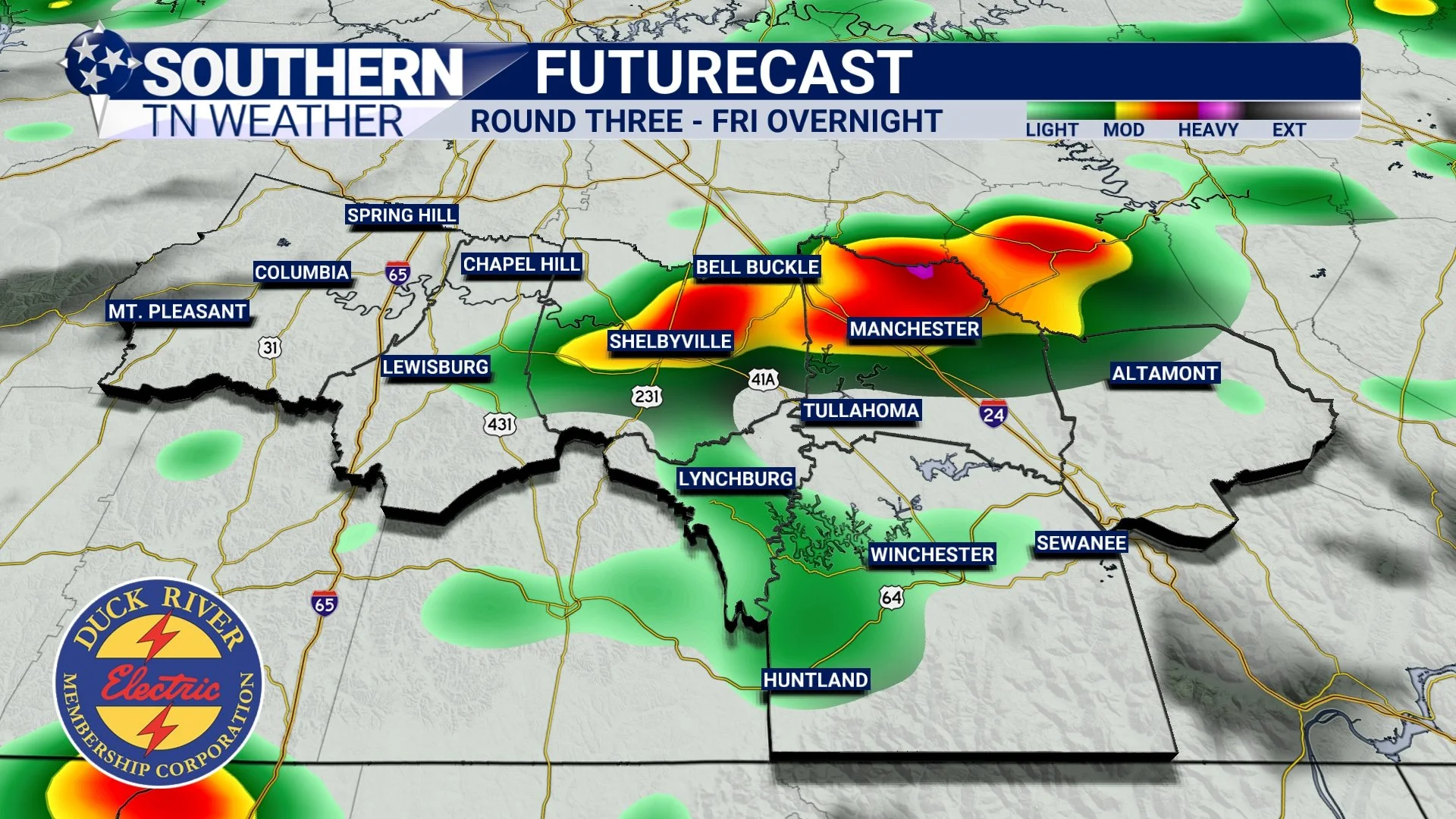
Futurecast - Round Three
Saturday and Sunday
Some showers will linger Saturday morning, but by midday we begin drying out. Saturday afternoon brings partly cloudy skies, and Sunday looks mostly sunny. Highs will remain mild in the mid-60s, with overnight lows in the 40s. A pleasant weekend is expected once Saturday morning’s showers move out.
Looking Into Next Week
Our next system arrives Monday afternoon through late Tuesday, bringing another round of showers and general thunderstorms. Severe weather concerns look low again, with better dynamics displaced to our south. Behind that system, a strong cold front will sweep through, bringing a noticeable temperature drop just in time for Thanksgiving.
The Bottom Line 🧾
• Rain and storms today, Friday afternoon, and Friday night
• Severe storm potential remains very low
• Rain totals through Friday: 0.5–1", with isolated 2" possible
• Weekend is mostly dry, especially Saturday afternoon and all day Sunday
• Another system arrives Monday–Tuesday, followed by much cooler temperatures
📰 Reminder: Our Southern Tennessee Weather Blog is updated Monday through Friday with fresh, locally tailored forecasts you can trust.
Be sure to follow along so you never miss an update!