
A Rainy End To the Work Week
The rest of today
Our first (and lighter) storm system of the week brought scattered showers and a few rumbles of thunder late last night and early this morning. Rainfall totals varied quite a bit across the area, with the heaviest amounts falling along a thin northwest-to-southeast corridor from Santa Fe → Central Marshall County → Southern Bedford County → Lynchburg → Tullahoma → Winchester → Sewanee. Some communities picked up close to an inch, while others, such as Manchester and Bell Buckle, barely saw measurable rainfall. Below is a look at radar-estimated rainfall over the past 24 hours.
The rest of Wednesday looks partly cloudy and comfortable, with temperatures remaining above average — a trend that will continue for much of the next week. Clouds will increase again tonight ahead of Weather System #2, which arrives Thursday. Patchy fog may also develop overnight into early Thursday morning.
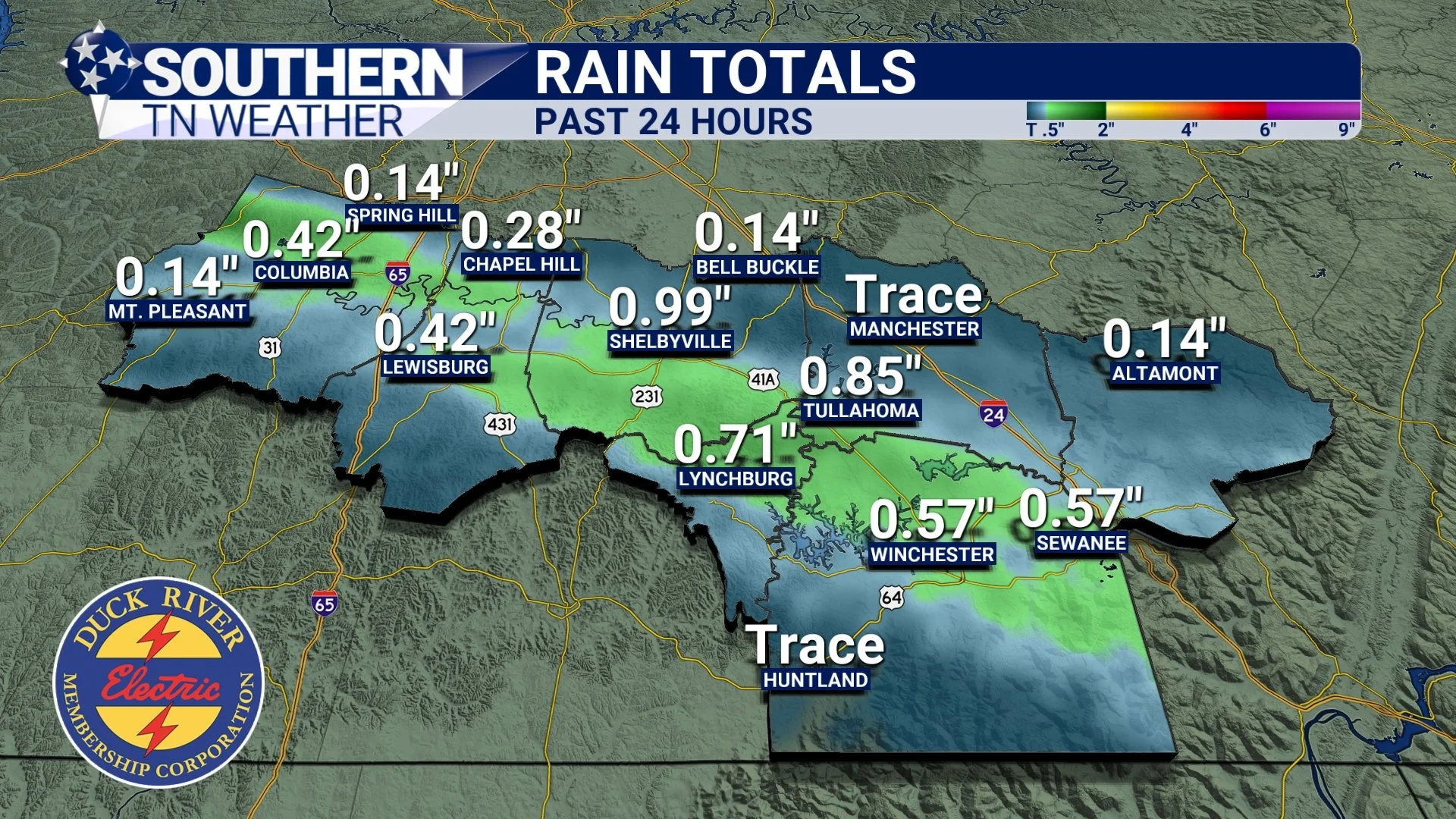
Observed rainfall totals over the past 24 hours
Thursday
As our next system approaches from the west, scattered showers and storms will begin filtering into the region on Thursday. While confidence is low that we’ll see much activity before lunchtime, I cannot rule out a stray shower or storm during the morning hours. The better chance for rain arrives near sunset and continues through midnight, with the “rain window” generally between 4 PM and 12 AM. This is a wide timeframe to account for scattered nature of the activity — it will not rain the entire time, but you’ll want an umbrella if you have Thursday evening plans.
As the National Weather Service highlighted this morning, storms are possible, but the risk of anything strong or severe is very low. Instability (storm fuel) simply isn’t impressive. Expect some noisy, occasionally heavy showers, but not much more. Early Friday morning looks to bring a brief lull before the next wave arrives.
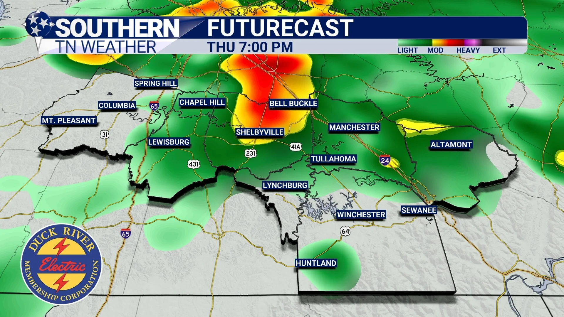
HRRR Futurecast - Tomorrow evening
Friday (and Beyond)
Friday’s timing is still a bit fuzzy since we’re outside the reliable short-range window, but the overall setup is clear. Scattered showers and some storms are expected from mid-morning Friday through Friday evening. Much like Thursday, the overall system looks robust, but instability remains modest, which greatly limits any severe weather potential. This aligns with today’s NWS forecast discussion, which states:
“Despite the unseasonable warmth, instability parameters are quite modest. Showers will be the primary mode, with only isolated storms. The risk of severe storms over the next couple of days remains very low.”
A cold front will sweep through early Saturday morning, which will finally dry the region out. The weekend looks mostly dry (minus a few passing showers Saturday Morning), with temperatures easing back into the low to mid-60s by Sunday — still above average, but cooler than the past few days.
Another system, featuring a stronger cold front, arrives Monday night into Tuesday of next week, bringing our next chance for rain and storms. Of course, I’ll have updates as this chance approaches.
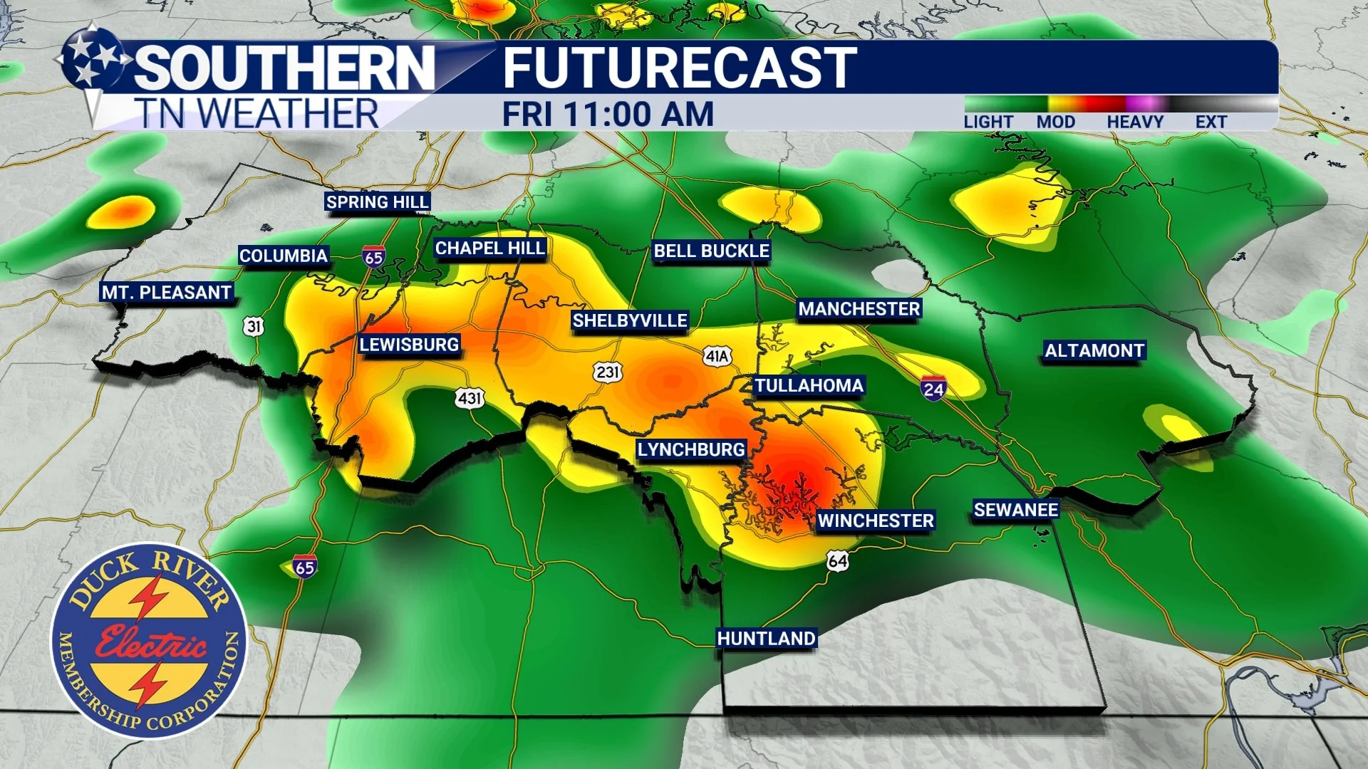
STNWX Futurecast - Friday Morning
Updated Rainfall Totals
Rainfall totals have trended upward in the latest NWS 7-day forecast … not because of Thursday or Friday alone, but because the next Tuesday system is now included in the 7-day window.
Generally:
- Around 2 inches of rainfall is expected area-wide
- Some locations could hit 2+ inches by Saturday morning, but confidence is low on pinpointing those spots
- Totals will vary due to scattered storm placement
Below is the updated NWS 7-day rainfall outlook.
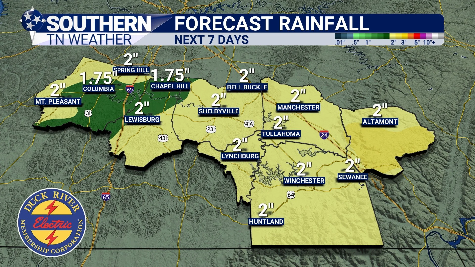
NWS Forecast Rainfall Totals - Next 7 Days
The Bottom Line 🧾
• Scattered showers/storms Thursday, and again Friday
• Severe weather risk is very low. Storms will mainly be noisy and brief
• Rain totals through the week: 1.5–2 inches, with localized higher amounts
• Weekend looks mostly dry, especially after Saturday Morning.
• Another system arrives early next week, followed by cooler temperatures
📰 Reminder: Our Southern Tennessee Weather Blog is updated Monday through Friday with fresh, locally tailored forecasts you can trust.
Be sure to follow along so you never miss an update!