
Scattered showers and storms Tuesday Night
A Warm November Day…
A warm front (the same one I mentioned in yesterday’s blog) pushed through the region late last night. Because of this, our actual “overnight low” occurred around 8 PM last night, and temperatures steadily climbed afterward as southerly winds pulled warmer air into the area. For reference, our normal overnight lows occur around sunrise.
As of this afternoon, most of Southern Middle Tennessee is sitting in the low to mid-70s, which is 10 to 15 degrees above average for mid-November. Clouds will increase through the evening ahead of our next weather-maker tonight.
Tonight: Scattered Showers and a Few Storms
We’ve spent a lot of time over the past week discussing Friday’s weather setup, but tonight deserves some attention too. In yesterday’s forecast package, I kept rain chances on the lower end — mainly because model data showed very limited moisture and weak forcing. However, rain chances have increased, and I now expect most of our area to see at least a quick-hitting shower or storm between 11 PM and 3 AM. Chances sit at around 80%.
What’s happening tonight?
Warm, humid air is lifting northward behind the warm front, while a weak frontal boundary approaches from the northwest. Ahead of this boundary, showers and thunderstorms will form across Western Kentucky between 6–10 PM and then slide southeast into Tennessee. A broken line of showers and storms is likely as this activity moves into our region late tonight.
Severe Weather Discussion
The Storm Prediction Center has placed far NW Maury County under a MARGINAL risk (level 1/5) for severe weather tonight. The main risk is focused to the northwest (between Paducah, KY and Clarksville, TN) where the best storm fuel (instability) exists. Locally, our question marks with stormage comes down to two things:
Surface-Based Convection:
For storms to become stronger and/or rotate, they must pull their air from the surface. Right now, there’s lingering uncertainty about whether storms will become truly surface-based in Southern Middle Tennessee, or anywhere for that matter.Storm Fuel (CAPE):
As I always emphasize this time of year, cool-season severe weather depends on how much instability can build before storms arrive. Tonight’s instability looks limited, which keeps our severe threat low.
This is not a “stay up all night” type of setup, but it is a good reminder to have the Southern Tennessee Weather App downloaded for warning alerts. I’ll also post updates on social media if needed. You can view an interactive radar any time at stnweather.com/radar.
Below you’ll see Futurecast, showing isolated showers/storms along a broken line early Wednesday morning, as well as the latest SPC outlook.
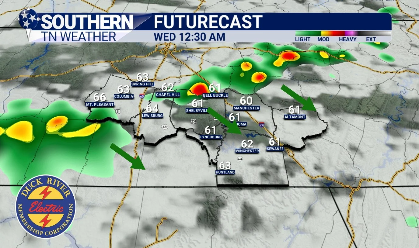
HRRR Weather Model - Tonight around Midnight
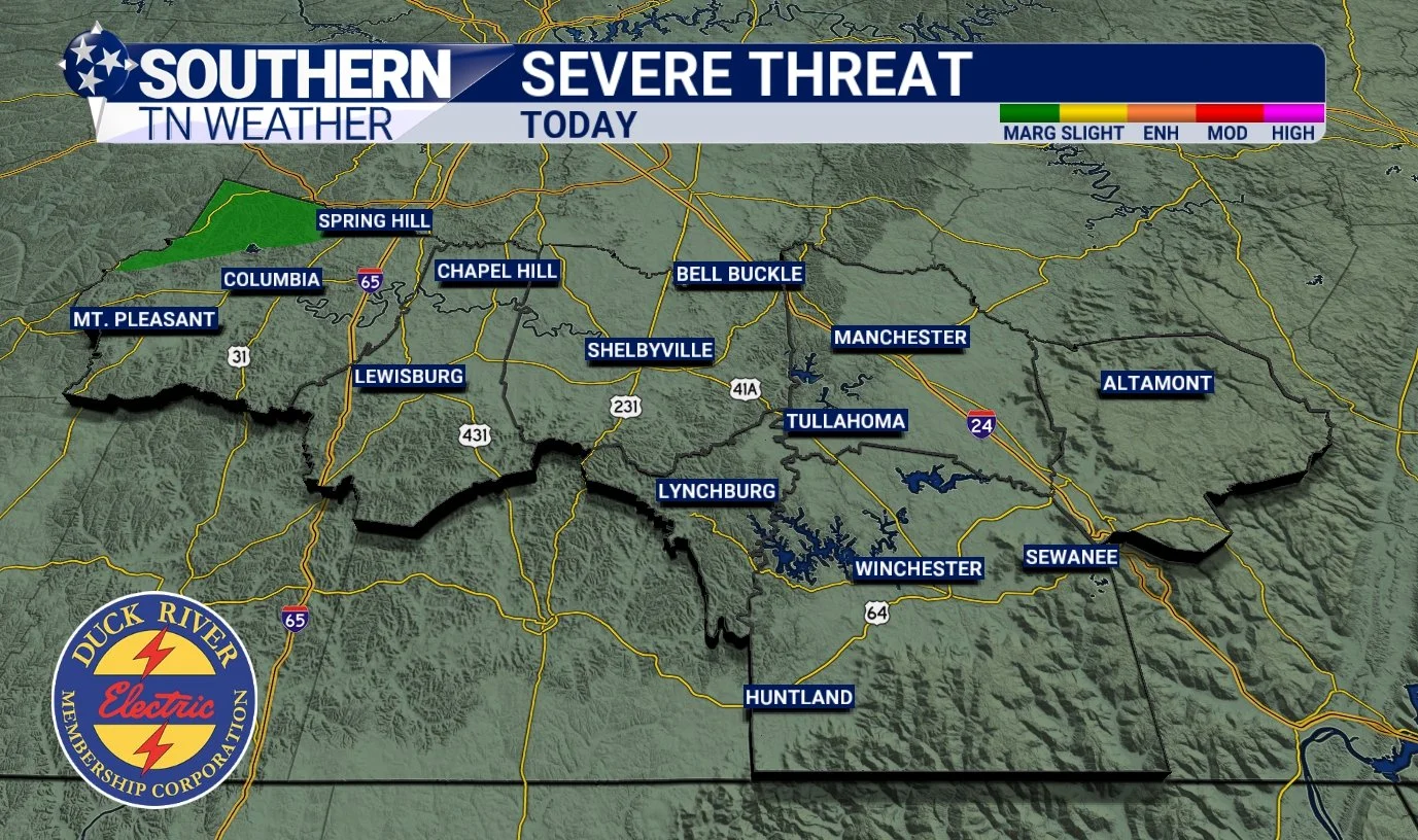
Storm Prediction Center Outlook Tonight
Wednesday
Lingering showers will be around early Wednesday morning as the front exits. By late morning and through the afternoon, we’ll transition to a mix of sun and clouds, and we should stay mostly dry the rest of the day. Don’t get used to the dry weather though, because more showers and storms arrive Thursday and Friday.
Updated Rainfall Totals (Next 7 Days)
Based on the latest NWS guidance, 1.0 to 1.5 inches of rain is expected across our area over the next 7 days. Depending on where heavier thunderstorms set up Friday afternoon and evening, localized pockets of 2+ inches are possible — but it is far too early to pinpoint where those might occur. Friday remains the most impactful weather day this week, with widespread showers and storms likely. Severe weather potential remains unclear for now. Just like tonight, it depends on instability and how much moisture we can build ahead of the front.
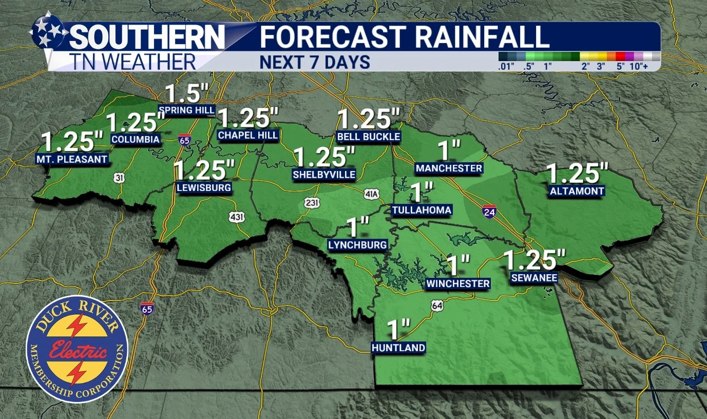
NWS Forecasted Rain Totals - Next 7 Days
Looking Ahead: Thursday Through the Weekend
• Thursday: Showers return in the afternoon and continue off and on.
• Friday: Stronger system arrives — widespread rain and storms likely. Could be worth watching for low-end severe potential (updates coming later this week).
• Saturday/Sunday: Mostly dry, cooler, and back to seasonable highs in the low to mid-60s.
• Next Week: Another system may arrive around next Tuesday, which I’m watching closely…
The Bottom Line 🧾
• Warm and breezy today with increasing clouds
• Scattered showers and storms arrive 11 PM–3 AM tonight
• Severe threat is very low, but a rogue strong storm cannot be ruled out
• Wednesday is mostly dry after morning showers
• Additional rain returns Thursday and Friday — Friday is the main day to watch
• Rainfall totals this week: 1.0–1.5 inches, with isolated 2+ possible
• Weekend looks mostly dry and seasonable, especially after Saturday morning
📰 Reminder: Our Southern Tennessee Weather Blog is updated Monday through Friday with fresh, locally tailored forecasts you can trust.
Be sure to follow along so you never miss an update!