
One More Round Of Heat And Storms… Then Summer's Best Air Arrives (For A Short Visit)

The Southern Tennessee Weather Blog is proudly presented by Heritage South Community Credit Union.
We Help When Others Won’t!
Visit https://www.heritagesouth.org/ today to see how HSCCU can help YOU!
We've made it to what will likely be the most active weather day of the week. Tuesday brings a one-two punch of dangerous heat during the afternoon followed by the potential for strong to severe thunderstorms later this evening and tonight. After that, one of the nicest air masses we've experienced all summer will settle into Southern Middle Tennessee. Let's break it down…
Dangerous Heat This Afternoon
Before we even talk about thunderstorms, we have to get through the heat. A HEAT ADVISORY remains in effect through 8:00 PM as afternoon heat index values climb between 105° and 110°, with a few isolated locations potentially feeling as hot as 115° for a brief time. Actual air temperatures will rise into the lower and middle 90s, but dew points in the upper 70s will make it feel much hotter.
If you're spending time outdoors this afternoon, stay hydrated, take frequent breaks in the shade or air conditioning, and know the signs of heat exhaustion and heat stroke.
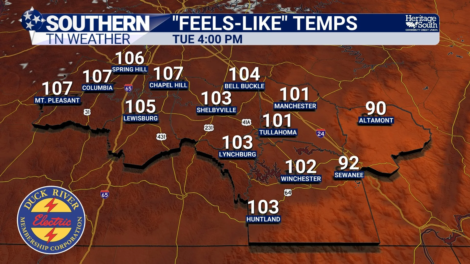
“FEELS LIKE” TEMPS - THIS AFTERNOON
Severe Storm Threat Begins This Evening
Attention then turns northward. A cold front stretching from Missouri into Illinois this afternoon will spark thunderstorms across Kentucky before those storms race south toward Tennessee later this evening. The Storm Prediction Center continues to place much of our area in a Level 1 of 5 Marginal Risk for severe weather.
The overall setup continues to favor a line of thunderstorms moving from north to south, which isn't the direction we usually see around here. The greatest window for stronger storms currently appears to be between 7:00 PM and 1:00 AM, although exact timing will vary depending on your location. The biggest concern remains damaging straight-line winds, but torrential rainfall and frequent lightning will accompany any stronger storms. While the tornado threat remains very low, it cannot be completely ruled out, particularly near the Tennessee-Kentucky state line where there is better atmospheric spin. Storms should be on a slow weakening trend on approach to our area. This is NOT looking like a very impressive system for us.
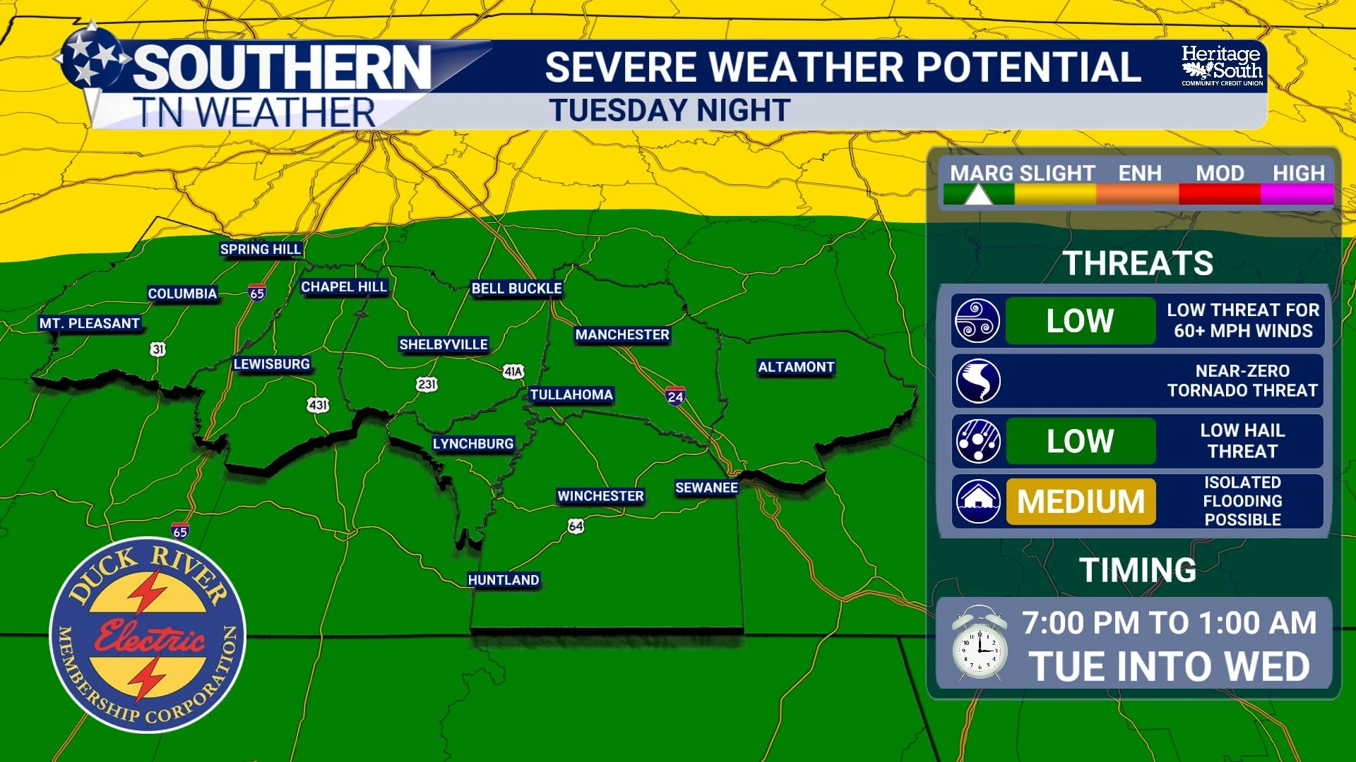
SEVERE WEATHER POTENTIAL - TUESDAY NIGHT
Flash Flooding Is Also A Concern
One aspect of tonight's forecast that deserves just as much attention is the heavy rainfall potential. The atmosphere remains exceptionally moist for late July, with enough tropical moisture in place to support rainfall rates of 1 to 2 inches per hour in the heaviest storms. Some high-resolution forecast models suggest isolated locations could receive 2 to 4 inches of rainfall if storms repeatedly move over the same area.
Considering how wet July has already been, it won't take much additional rain to produce localized flash flooding. A FLOOD WATCH has been issued for Bedford, Coffee, Marshall, and Maury County through Wednesday morning.
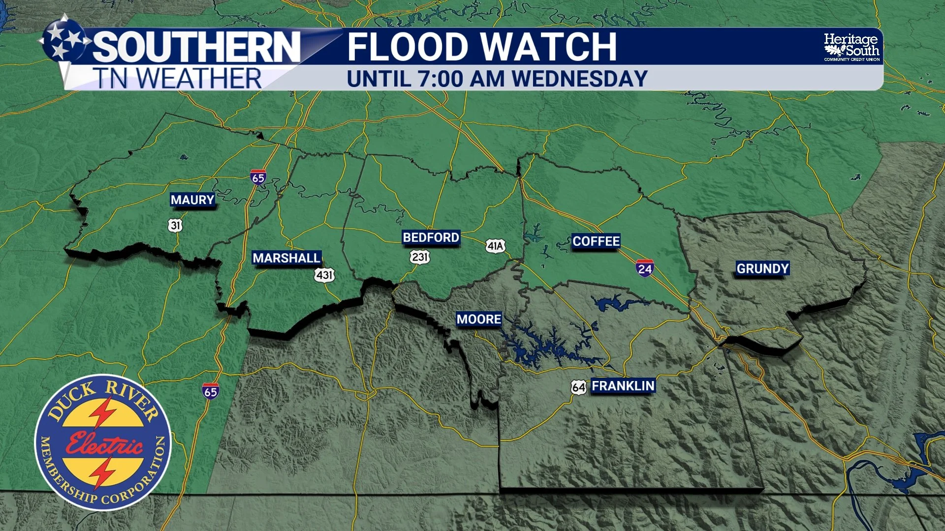
FLOOD WATCH
Finally… A Taste Of Fall?
No... not quite. But it's probably going to feel that way compared to what we've experienced recently. Behind tonight's cold front, noticeably drier air begins filtering into the region throughout Wednesday before fully settling in Wednesday night.
By Thursday morning, many communities will wake up to temperatures in the lower and middle 60s—something we haven't experienced in quite a while. Afternoon highs Thursday will only reach the lower to middle 80s, and perhaps even better, dew points will fall into the lower 60s. That means stepping outside won't immediately feel like walking into a sauna.
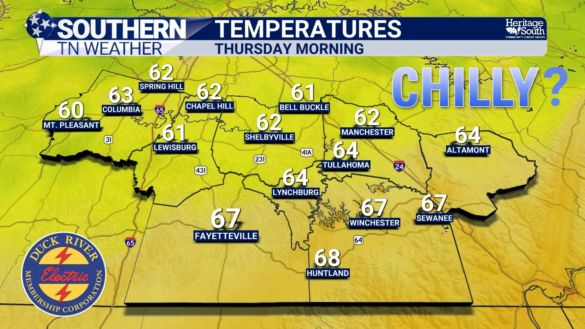
TEMPERATURES - THURSDAY MORNING
It Won't Last Forever
As refreshing as late week looks, remember this is still late July. Forecast guidance already hints at another disturbance approaching sometime Friday night into Saturday, bringing at least a chance for showers and thunderstorms back into the forecast. Even so, the second half of this week still looks substantially more comfortable than what we've endured recently, and it'll be a welcome break from both the heat and humidity.
The Bottom Line 🧾
🥵 A Heat Advisory remains in effect until 8:00 PM with heat index values between 105° and 110°, and isolated spots approaching 115°.
⛈️ Strong to severe thunderstorms are expected between 7 PM and 1 AM.
💨 Damaging winds remain the primary severe weather threat.
🌧️ Torrential rainfall could lead to localized flash flooding, especially where storms repeatedly track over the same locations.
🌤️ A much cooler and noticeably less humid air mass arrives Wednesday night.
😌 Thursday and Friday will feature some of the most comfortable weather we've seen all summer, with highs in the 80s and mornings in the 60s.
🌦️ Rain chances begin creeping back into the forecast next weekend, but nothing looks as widespread as the pattern we've experienced over the past couple of weeks.
📰 Reminder: The Southern Tennessee Weather Blog, presented by Heritage South Community Credit Union, is updated Monday through Friday with fresh, locally tailored forecasts you can trust.
