
Don't Get Used To This Weather… Weekend Rain And Next Week's Heat Are Ahead

The Southern Tennessee Weather Blog is proudly presented by Heritage South Community Credit Union.
We Help When Others Won’t!
Visit https://www.heritagesouth.org/ today to see how HSCCU can help YOU!
If you've stepped outside today, you've probably noticed it already. The oppressive humidity is gone. The air feels noticeably lighter. Temperatures are running well below where they've been for most of July, and after weeks of feeling like we were living in a sauna, Southern Middle Tennessee is finally getting a well-deserved break.
We aren't completely done with the rain just yet (showers are still lingering across parts of the area today) but many communities will enjoy much more comfortable conditions through Friday before rain chances become more widespread again this weekend.
Enjoy Today And Much Of Friday
Thursday and much of Friday will feature some of the nicest weather we've experienced all summer. Afternoon highs will generally stay in the lower to middle 80s with dew points falling into the lower and middle 60s. That's a dramatic improvement compared to the upper 70s dew points and heat index values over 105° we dealt with earlier this week.
A few scattered showers will continue to favor our southern counties and areas closer to the Alabama state line today into Friday, but many communities farther north will see extended periods of dry weather. If you've been waiting for a good opportunity to spend time outside, today and much of Friday are probably your best bet.
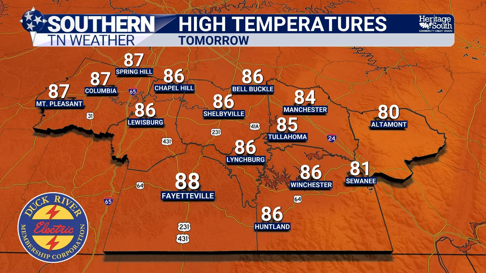
HIGH TEMPS - FRIDAY
Rain Chances Increase Friday Night And Saturday
Our next weather system arrives Friday night and sticks around through much of Saturday. An upper-level disturbance moving through the Tennessee Valley will interact with lingering tropical moisture, bringing another round of showers and thunderstorms to the region.
Unlike Tuesday night's storms, severe weather is not expected at this time. Instead, the biggest concern will be periods of moderate to heavy rainfall, especially if multiple rounds of showers move across the same locations. Most forecast guidance suggests rainfall totals between one-quarter and one-half inch across much of southern Middle Tennessee, although locally higher amounts are certainly possible underneath heavier thunderstorms. If you have outdoor plans Saturday, don't cancel them just yet—but have a backup plan and be prepared for periods of rain.
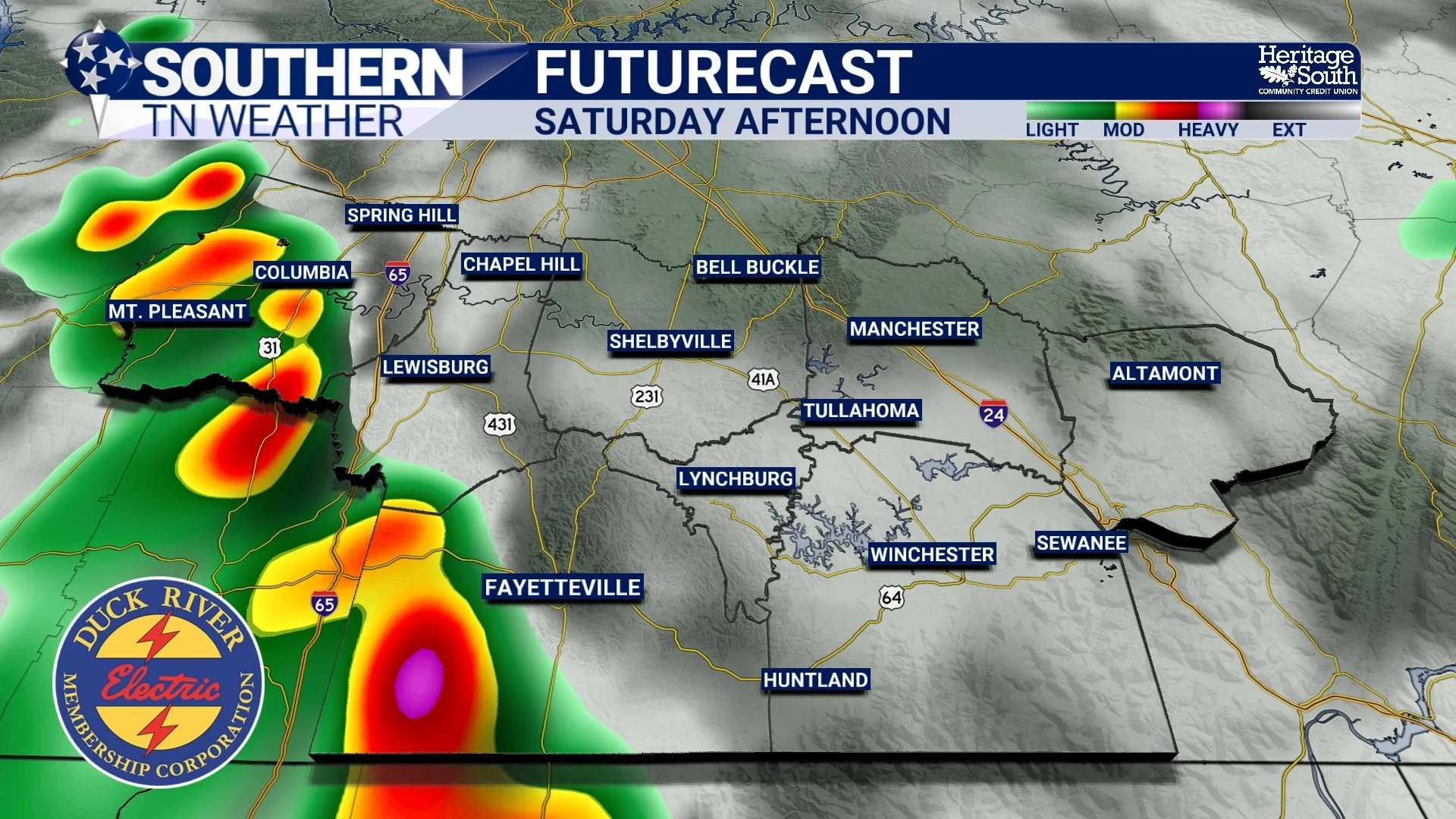
FUTURECAST - SATURDAY AFTERNOON
Sunshine Returns... Along With The Heat
By Sunday, the upper-level disturbance moves away and high pressure begins building back into the Southeast. That means rain chances quickly decrease while temperatures steadily climb. Highs return to around 90° on Sunday before climbing into the lower and middle 90s Monday and Tuesday. Humidity will also begin increasing again, pushing heat index values back toward Heat Advisory criteria early next week.
While an isolated afternoon thunderstorm can't be ruled out (this is still summertime in Tennessee) the weather pattern next week looks much quieter than what we've experienced for much of July.
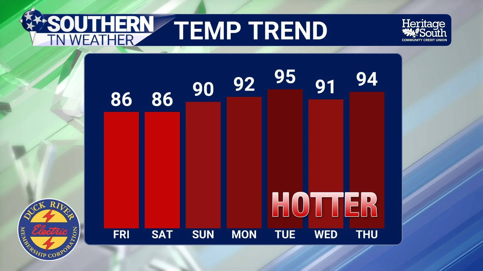
TEMPERATURE TREND - NEXT 7 DAYS
Summer Isn't Going Anywhere
As refreshing as this week's cool-down has been, it was never going to last very long. Late July is climatologically one of the hottest times of the year, so a return to hot and humid weather isn't surprising.
The encouraging news is that we don't currently see another prolonged stretch of widespread thunderstorms. Instead, next week appears to feature a much more typical late July pattern: hot afternoons, humid conditions, and only isolated pop-up storms.
The Bottom Line 🧾
😌 Thursday and much of Friday feature some of the nicest weather we've seen all summer.
🌦️ Scattered showers will linger across southern Middle Tennessee through Friday, but many communities will enjoy long dry stretches.
🌧️ Rain chances become more widespread Friday night and Saturday.
⛈️ No severe weather is expected at this time, although locally heavy rainfall will be possible.
☀️ Drier weather returns Sunday.
🥵 Heat and humidity build back into the region early next week, with heat index values once again approaching advisory levels.
🌤️ Next week's weather looks much more typical for late July, with mainly isolated afternoon thunderstorms instead of widespread daily rain.
📰 Reminder: The Southern Tennessee Weather Blog, presented by Heritage South Community Credit Union, is updated Monday through Friday with fresh, locally tailored forecasts you can trust.
