
Rain This Weekend: How Much, When, and Where?

The Southern Tennessee Weather Blog is proudly presented by Heritage South Community Credit Union.
We Help When Others Won’t!
Visit https://www.heritagesouth.org/ today to see how HSCCU can help YOU!
After weeks of talking about drought, brown grass and rain that always seemed to find somewhere ELSE to fall, we've finally reached a weekend where widespread rain is actually in the forecast across Southern Middle Tennessee. But there have been some pretty important changes over the past 24 to 48 hours.
Earlier forecasts supported the potential for a more substantial soaking rainfall across much of the region. While we are STILL expecting beneficial rain this weekend, confidence in those higher rainfall totals has decreased. The system moving toward us is weakening, atmospheric moisture isn't quite as impressive as earlier forecasts suggested in some areas, and the latest guidance has generally backed away from widespread multi-inch totals.
In other words, this is still good news for our drought, but it probably isn't going to be a drought buster. So let's answer the three questions everybody actually cares about: How much rain are we getting, when is it going to rain, and where will the most rain fall?
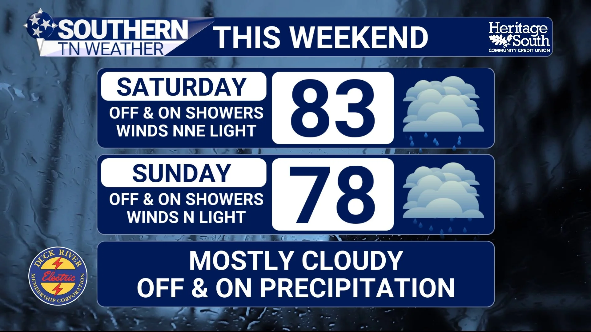
STNWX - THIS WEEKEND
How Much Rain Are We Talking About?
For most of Southern Middle Tennessee, I would set expectations somewhere around a half-inch to one inch of rain through the weekend, with some locations potentially receiving more and others receiving less. That's a pretty significant change from some of the 2–4 inch totals that appeared in guidance earlier this week, and there's a meteorological reason behind that change. The low-pressure system responsible for bringing this moisture into our region is weakening as it approaches, which means the overall forcing needed to produce widespread heavy rainfall isn't quite as strong as previously anticipated.
We've also learned something important from actual weather balloon observations Friday morning. The atmosphere is certainly moist, but moisture levels around Middle Tennessee were somewhat lower than some earlier model forecasts had projected. That combination of weaker forcing and somewhat less moisture has brought expected rainfall totals down. This is a perfect real-world example of something we've talked about before: forecasts become more specific as we get closer and receive better information. Several days ago, the larger-scale pattern strongly supported a soaking rainfall event. Now that the system is actually approaching and we're sampling the atmosphere directly, we can refine exactly how much rain is likely to fall.
That doesn't mean everybody receives exactly 0.73 inches or 0.91 inches. Rainfall will still be uneven, particularly where thunderstorms develop. A location underneath a heavier shower or repeated rounds of rain could easily finish above an inch, while another location nearby could receive considerably less. The important takeaway is that widespread multi-inch rainfall no longer appears likely across most of Southern Middle Tennessee. Any rain is GREAT news considering our rapidly worsening drought, but we're probably not going to erase weeks of rainfall deficits with this system.
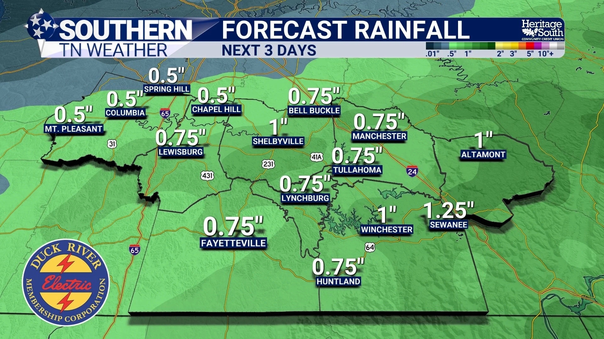
FORECAST RAINFALL - NEXT 3 DAYS
When Will It Rain?
This isn't going to be one continuous rain from Friday afternoon through Sunday night. Instead, think of the weekend as several opportunities for rain separated by occasional breaks. Our first round arrives Friday afternoon and evening. A larger area of rain moving northeast from Mississippi and western Tennessee should begin reaching portions of Southern Middle Tennessee later Friday afternoon, generally around or after 5–7 PM, but there is already some rain occurring across Maury County.
That timing is obviously important with high school football games happening across the region Friday night. Rainfall Friday evening should remain somewhat scattered and uneven, especially farther east. Some games could deal with a steady shower or even a thunderstorm, while others may only receive brief rain or potentially stay dry for a good portion of the evening. Thunderstorms are possible, but instability and wind shear are fairly limited, so severe weather is NOT expected. Rain coverage should generally decrease somewhat later Friday night as daytime heating disappears, although scattered showers may linger.
Saturday becomes a little more complicated. The front responsible for our rain should settle southward and eventually stall near or just south of Southern Middle Tennessee. Moist air will continue flowing up and over that boundary, allowing additional showers to develop even though the front itself isn't moving much. That means we'll probably have off-and-on showers Saturday, but I would NOT call the entire day a washout. There should be dry periods mixed in, and exactly when those breaks occur will vary depending on location.
Then we get to Sunday, which may ultimately become the wettest portion of the weekend for some of us. A stronger upper-level disturbance will approach late Saturday night into Sunday and provide another push of lift across the region. With plenty of moisture still hanging around, a more widespread area of rain is expected to develop. Sunday currently has the best opportunity for a longer period of widespread rainfall, especially across the southern half of our coverage area. Showers may linger into Sunday evening before the entire system finally begins moving away. By early Monday, a much drier air mass should start taking control. So if you're trying to plan the weekend, the easiest way to think about it is: Friday afternoon/evening: First round arrives, but coverage remains somewhat scattered. Saturday: Off-and-on showers with dry periods in between. Late Saturday night through Sunday: Better opportunity for more widespread rainfall. Sunday night into Monday: Rain gradually exits and MUCH nicer fall weather begins moving in.
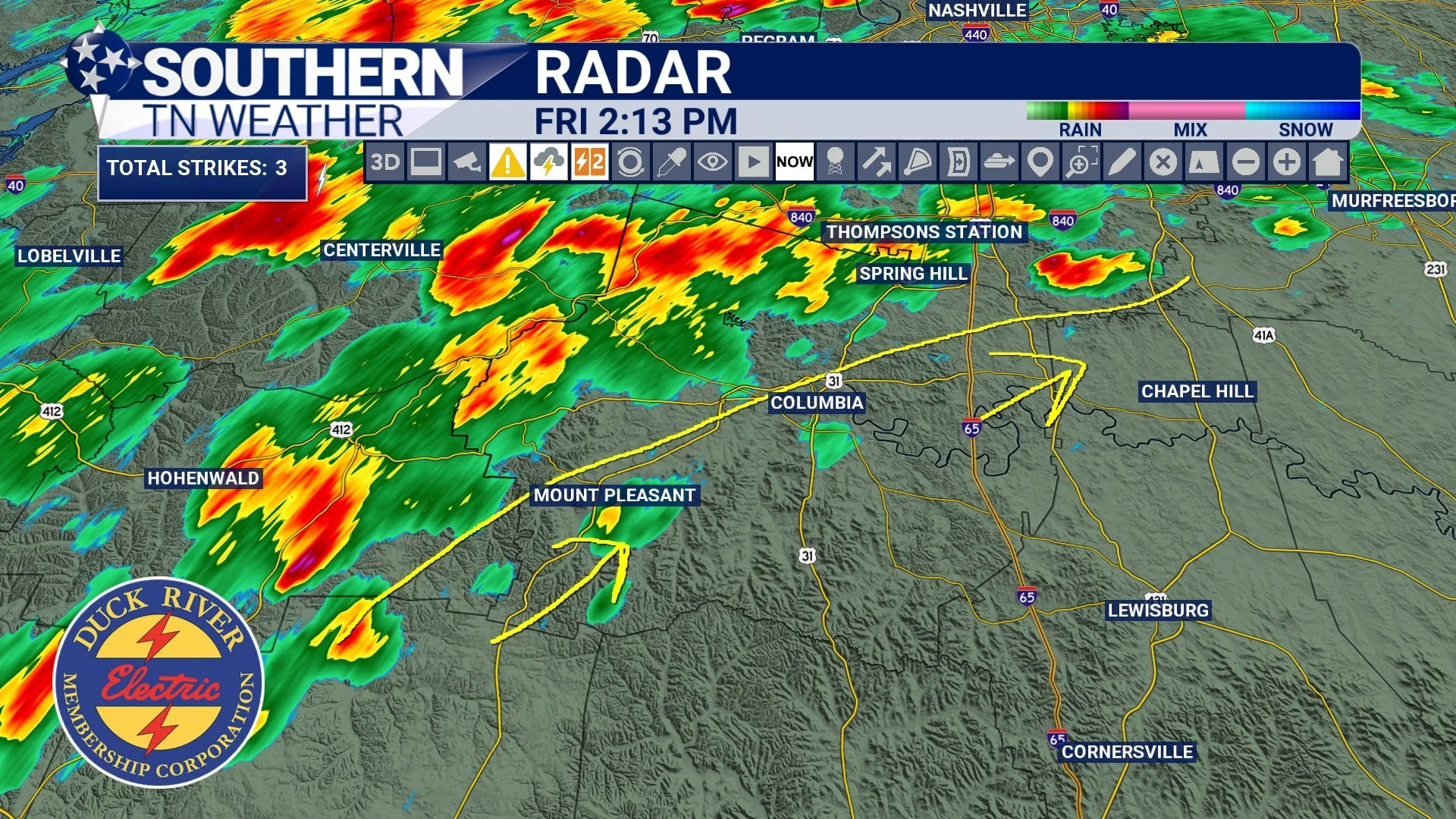
RADAR - 2:13 PM
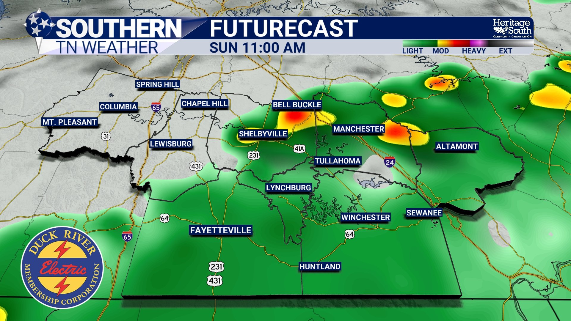
FUTURECAST - LATE SUNDAY MORNING
Where Will the Most Rain Fall?
This is probably the toughest question because rainfall totals will not be distributed evenly across Southern Middle Tennessee. Right now, the overall setup appears to favor the southern and southeastern portions of the region for the greatest rainfall coverage through the weekend. That would include areas closer to the Alabama state line and portions of the Cumberland Plateau. There are a couple of reasons for that.
First, the front should gradually settle southward Friday night and Saturday before stalling. Moisture will continue overrunning that boundary, keeping showers around, with the better chances generally favoring areas south of Interstate 40. Then, heading into Sunday, the strongest forcing associated with the next disturbance may pass even farther south. That creates some uncertainty because a relatively small shift north or south could determine whether Southern Middle Tennessee gets into a corridor of heavier rainfall or whether those higher totals remain farther south across Alabama. Our southern counties also have a better opportunity to tap into some of the deeper atmospheric moisture this weekend. By Saturday night and Sunday, precipitable water values could approach 2 inches, meaning the atmosphere will be capable of producing very efficient rainfall.
That's where we need to watch for locally heavier totals. If showers repeatedly move across the same location, something meteorologists call training, rainfall could add up quickly. Storm motions may also become fairly slow at times, increasing the possibility that a few communities receive substantially more rain than surrounding locations. So while most of us may end up somewhere around that half-inch to one-inch range, localized totals above an inch remain very possible, especially farther south and east.
MUCH Better Fall Weather Is Waiting Behind It
Once we finally get this system out of here, we're going to be rewarded with some pretty fantastic fall weather. Clouds and rainfall will already knock temperatures down this weekend, with Saturday highs generally in the upper 70s and lower 80s and Sunday potentially struggling to get much beyond the middle and upper 70s in some locations.
Then a reinforcing push of cooler and considerably drier air arrives behind the front Sunday night into Monday. High temperatures should begin next week primarily in the 70s to lower 80s, but the mornings are where you'll REALLY notice the difference. Lows should fall into the 40s and 50s across Southern Middle Tennessee through the first half of next week.
After the ridiculous heat we endured throughout September, I don't think anybody is going to complain about needing a light jacket for the morning commute. Okay... maybe somebody will. There's always one. 😂
The Bottom Line 🧾
🌧️ Widespread rain is still expected across Southern Middle Tennessee this weekend, but projected totals have decreased from earlier forecasts.
📏 Most locations should generally receive around 0.50–1.00 inch, although localized totals above one inch remain possible.
📉 This does NOT currently look like the widespread 2–4 inch drought-busting rainfall event that earlier guidance suggested.
🏈 Friday afternoon and evening: Scattered showers and a few isolated thunderstorms arrive, particularly from west to east. Some high school football games could be wet, but rainfall will remain uneven.
🌦️ Saturday: Off-and-on showers remain possible with dry periods mixed in. Rain chances increase again later in the day.
☔ Late Saturday night through Sunday: This currently appears to offer the best opportunity for more widespread and potentially heavier rainfall.
📍 Southern and southeastern portions of Southern Middle Tennessee currently have the better opportunity for higher weekend rainfall totals.
⛈️ A few thunderstorms are possible, but severe weather is NOT expected.
💦 Localized heavy rainfall remains possible, particularly Sunday, if slow-moving showers repeatedly pass over the same locations.
🌵 This rainfall should provide some beneficial short-term drought relief, but it will NOT erase our drought.
🍂 Cooler and drier air arrives Sunday night into Monday, setting us up for some BEAUTIFUL fall weather next week.
🥶 Morning lows could fall into the 40s and 50s during the first half of next week.
📰 Reminder: The Southern Tennessee Weather Blog, presented by Heritage South Community Credit Union, is updated Monday through Friday with fresh, locally tailored forecasts you can trust.
