
Rain This Weekend, Warmer Weather Next Week

The Southern Tennessee Weather Blog is proudly presented by Heritage South Community Credit Union.
We Help When Others Won’t!
Visit https://www.heritagesouth.org/ today to see how HSCCU can help YOU!
Southern Middle Tennessee is sitting in a brief lull in the active weather pattern today, but that quiet stretch is temporary. High pressure is providing dry and fairly mild conditions through Friday, before a southern-stream system brings a widespread, soaking rain to the region this weekend. After that system moves out, the overall pattern favors above-normal temperatures heading into next week.
Today: High Pressure in Control
A broad area of surface high pressure is centered from the Ohio Valley into the Deep South, keeping Southern Middle Tennessee dry today. High pressure promotes sinking air, which suppresses cloud growth and precipitation. That is why skies are mostly sunny to partly cloudy this afternoon despite an active pattern elsewhere in the country. Temperatures today are noticeably cooler than earlier this week but still comfortable, reaching the upper 50s in most locations. Winds remain light out of the northeast, and the air mass is dry and stable. Overall, it is a quiet and uneventful February day.
Tonight will be cool but not cold, with lows settling into the 30s under partly cloudy skies.
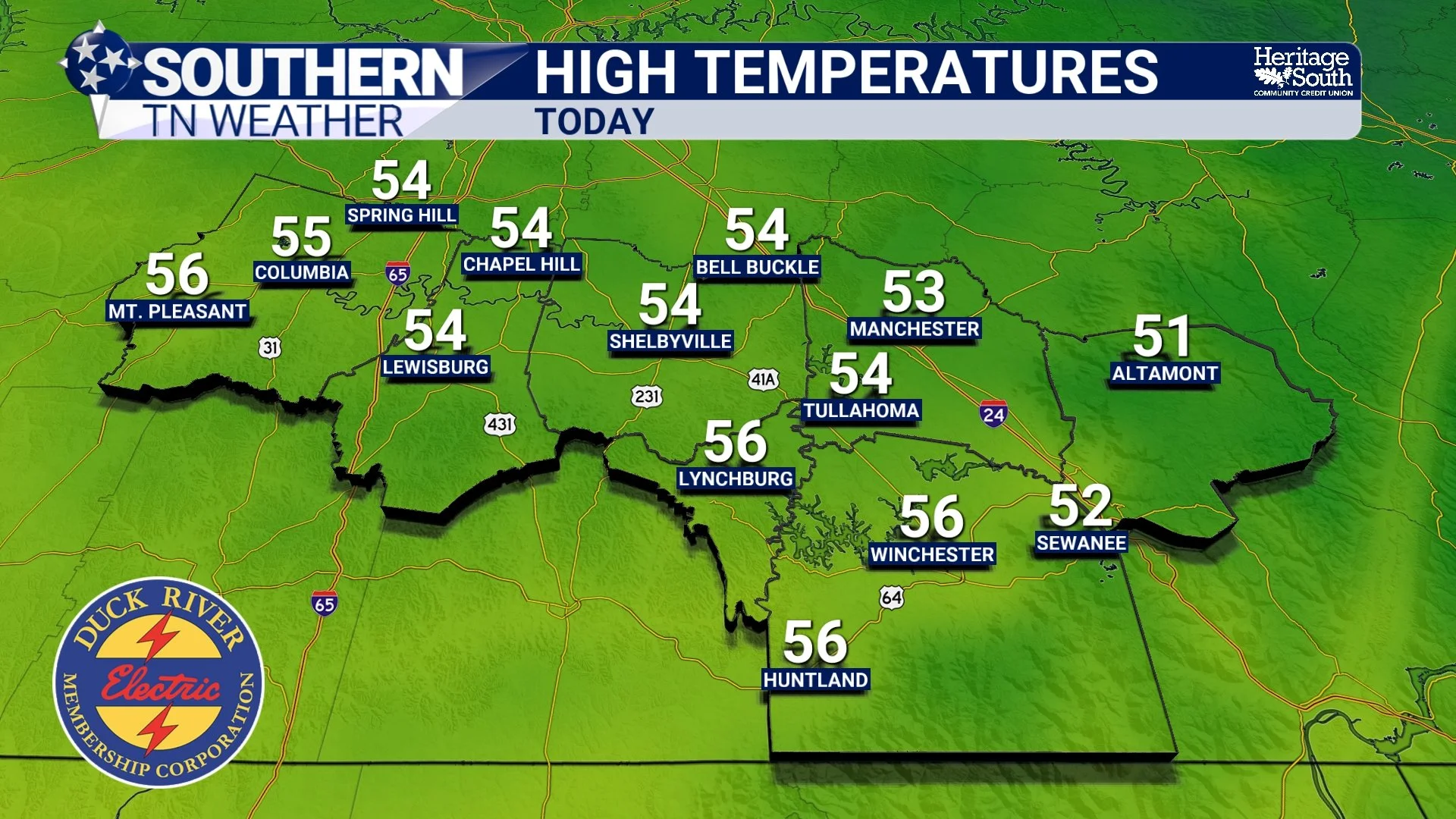
HIGH TEMPERATURES - TODAY (THURSDAY)
Friday: A Subtle Warm-Up Begins
By Friday, the surface high shifts east toward the Atlantic Coast. As it does, winds gradually turn from northeasterly to easterly and eventually southeasterly. That wind shift allows slightly warmer air to begin moving back into Southern Middle Tennessee. Highs Friday afternoon climb into the lower 60s, which is several degrees above normal for this time of year. Despite increasing high clouds later in the day, conditions remain dry through Friday night. This sets the stage for the next system without any weather-related concerns to close out the work week.
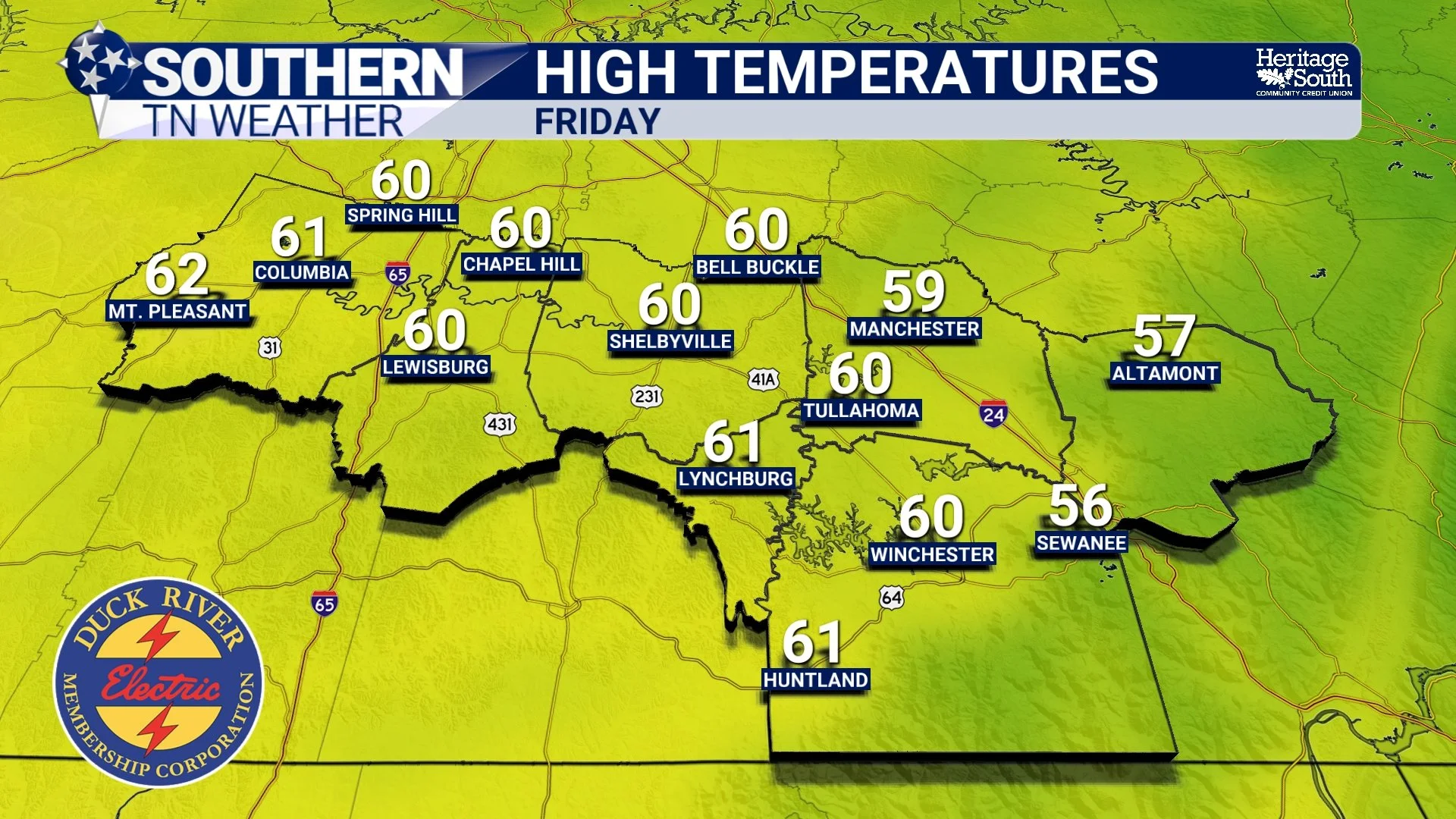
HIGH TEMPERATURES - TOMORROW (FRIDAY)
The Weekend: Widespread Rain Likely
Attention then turns to the weekend, when a southern-stream disturbance moves out of the Plains and into the Tennessee Valley. Unlike quick-moving fronts, this system taps into Gulf moisture and slows down as it approaches, allowing rain coverage to become widespread. Rain chances increase Saturday, but the most consistent and widespread rainfall is expected Saturday night into Sunday. Forecast soundings show limited instability across Southern Middle Tennessee, which is important. While a few embedded thunderstorms cannot be ruled out, the lack of strong instability keeps storms weak and rainfall rates more manageable.
Current projections continue to support 1 to 2 inches of total rainfall across the region over the course of the weekend. Shown below is the latest National Blend of Models output for this weekend, showing a widespread 1-2 inches of rain. This rain falls over many hours rather than all at once, which significantly limits flooding concerns. At this time, flooding is not expected, though brief ponding on roads is possible during heavier periods. Rain gradually tapers Sunday afternoon into Sunday night as the system exits to the east.
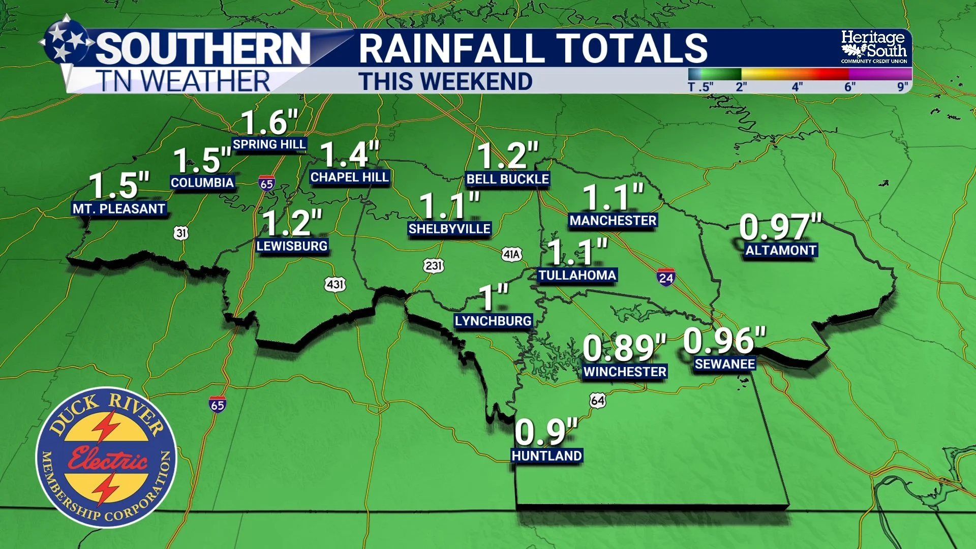
RAINFALL PROJECTIONS (NBM) - THIS WEEKEND
Early Next Week: Warm Air Returns
Behind the weekend rain, the pattern quickly turns warmer again. Upper-level ridging rebuilds across the central and eastern United States, promoting rising temperatures and more stable conditions. By early next week, highs across Southern Middle Tennessee return to the 60s, with some locations potentially approaching 70 degrees. Overnight lows also moderate into the 40s and 50s. This warmth looks more persistent than previous warm-ups, with ensemble guidance supporting above-normal temperatures for several consecutive days.
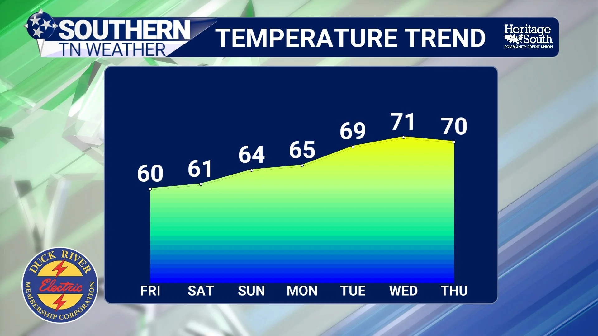
TEMPERATURE TREND - NEXT 7 DAYS
The Bottom Line 🧾
• Dry and quiet weather continues through Friday
• Highs warm into the lower 60s by Friday afternoon
• Rain chances increase Saturday, becoming widespread by Saturday night
• A soaking rain of 1–2 inches is expected this weekend
• Flooding is not expected at this time
• Above-normal temperatures return early next week
📰 Reminder: The Southern Tennessee Weather Blog, presented by Heritage South Community Credit Union, is updated Monday through Friday with fresh, locally tailored forecasts you can trust.