
Quiet start to the week… first freeze on the horizon!
Work Week Weather
A quiet stretch of weather is on tap for Southern Middle Tennessee through at least Thursday, thanks to a broad area of high pressure overhead. Temperatures will run above average for this time of year, with highs climbing into the low to mid-70s under plenty of sunshine. Tonight, a little light patchy frost or fog is possible once again, but this still doesn’t look like a freezing setup for our area.
Our next chance for rain doesn’t arrive until Friday at the earliest. Both major global weather models — the GFS and the European — are hinting at some elevated storm fuel and stronger wind energy values in our region by Friday, which could support a few thunderstorms. At this point, the severe threat remains low, but it’s something I’ll keep an eye on. As always, I’ll have updates right here in the blog as the week progresses.
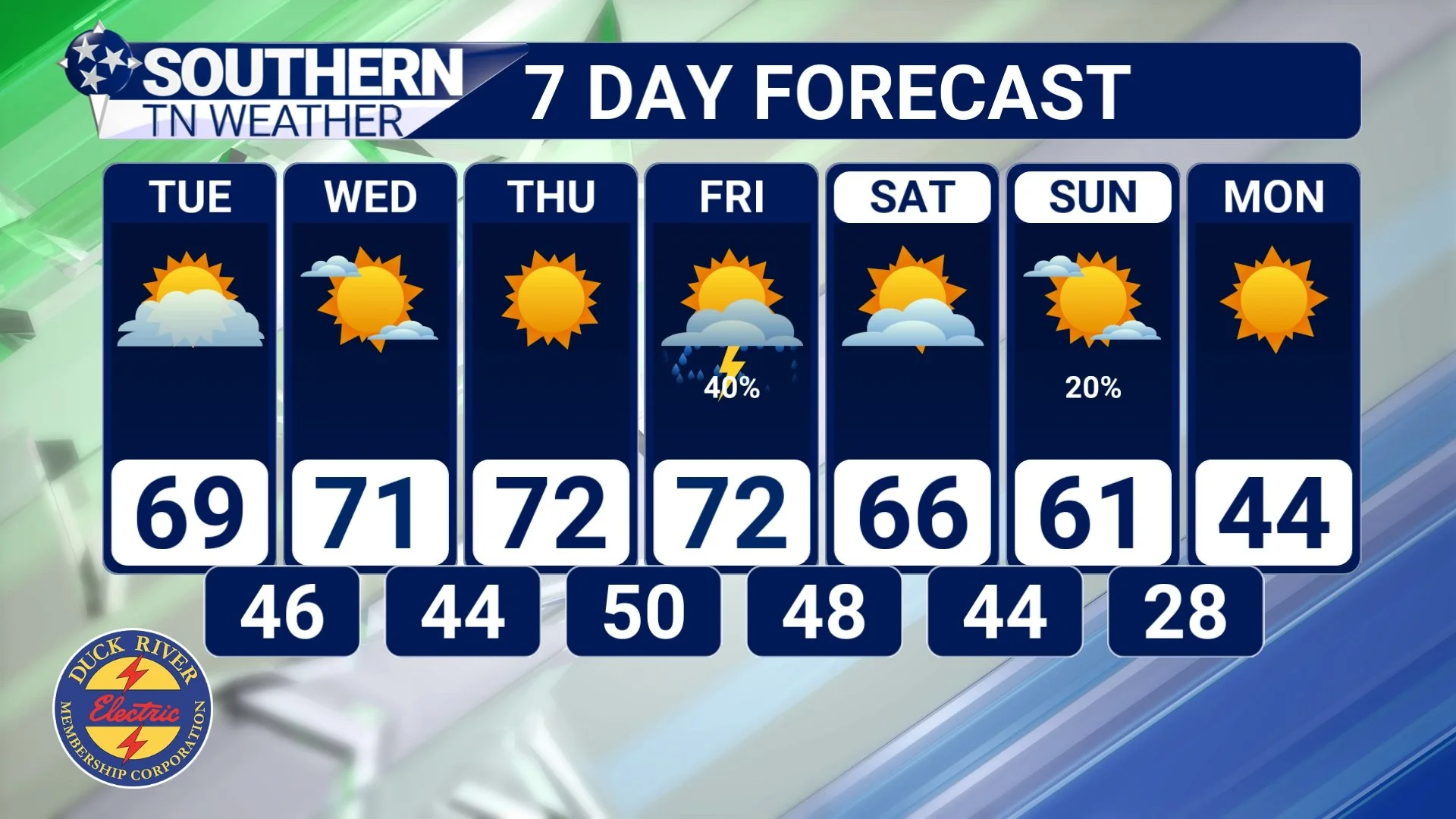
STNWX 7-Day Forecast
Barrage of cold fronts incoming
Our rain chance on Friday will actually be part one of a two-part cold front setup heading into the weekend. The first, weaker front moves through Friday night into Saturday morning. A second, much stronger front will follow on Sunday. For now, rain chances with that Sunday system don’t look overly impressive, but I do have at least a 20% chance of showers in the forecast as it moves through.
The reason this is being labeled a strong cold front is simple: it’s going to get downright chilly once it passes. You may have already noticed that I’ve got temperatures dropping to around 28 degrees next Sunday night into Monday morning. The latest run of our futurecast model is even colder, showing lows closer to 25 degrees in some spots. Monday itself will be quite brisk, with daytime highs struggling to reach the mid-40s. I’ve been saying our first freeze of the season would likely arrive in November — and now we’re staring at a very strong signal that it’s finally on the way.
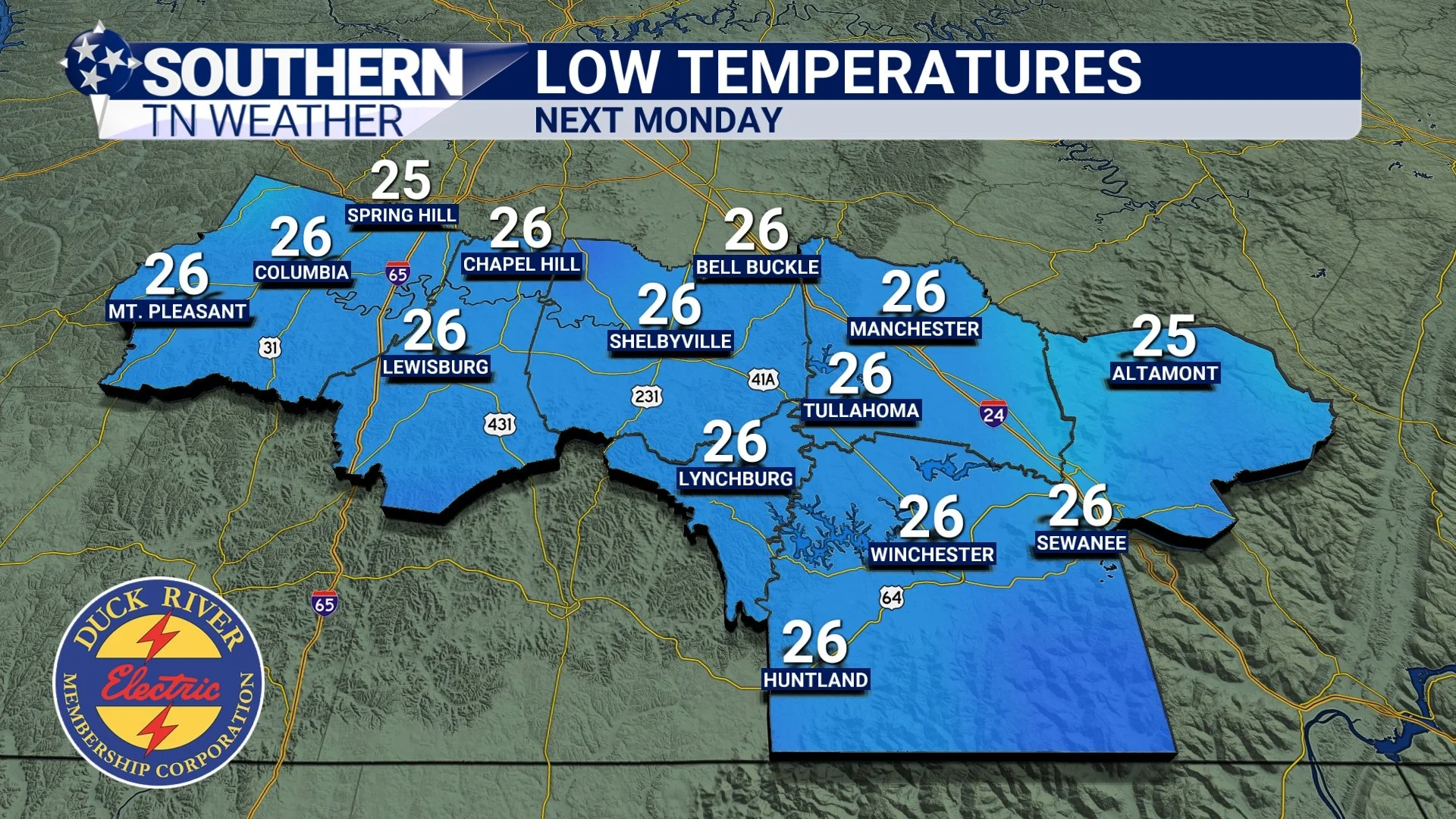
Futurecast low temperatures next Monday morning
Clipper system Monday…?
Some of you may have already seen the “buzz” on Facebook about a clipper system swinging through early next week. Before we talk impacts, I’d be doing a disservice if I didn’t briefly explain what a clipper system actually is.
A clipper system (often called an Alberta Clipper) is a fast-moving area of low pressure that forms up in western Canada (usually around Alberta) before quickly diving southeast across the northern U.S. They move fast (hence the name clipper) and because they originate in cold, dry Canadian air, they typically don’t have much moisture to work with. For our area, that usually means increased cloud cover and a quick shot of colder air behind the system. Snow? Usually not — unless you’re in the higher elevations of the Northern Plateau or the Smokies, which can occasionally squeeze out a dusting to inch. But here in Southern Middle Tennessee, clippers are more of a “clouds and cold” type of deal.
So now that we know what a clipper is, how do they usually impact us? As mentioned above, these systems rarely bring meaningful precipitation to our region. Every once in a while, we can luck into a very light dusting, but that’s about the extent of it. The last decent clipper I can recall was way back on November 29th, 2020 when we got an inch of snowfall across the area — so yeah, it’s been a minute.
A few folks have been sharing screenshots of the latest American weather model run trying to “stir the pot” about the possibility of flakes flying early next week. But right now, I just don’t see any good chance for precipitation of any kind (let alone snow). Could this change? Absolutely — we’re still a week out. But for now, let’s not get our hopes up. This is also a good reminder to be careful about what you share online. Uncle Joe’s Weather Forecast Center in Mom’s Basement might be fun to browse, but should we treat it seriously? I’ll let you decide. 😅
The Bottom Line 🧾
• Nice week ahead.
• Rain returns Friday PM.
• Double cold fronts and lower temperatures this weekend into early next week.
📰 Reminder: Our Southern Tennessee Weather Blog is updated Monday through Friday with fresh, locally tailored forecasts you can trust.
Be sure to follow along so you never miss an update!